
MAY 2019: Wednesday Storm Complex/Scattered Showers To End May
-
Andrew
- Site Admin

- Posts: 3508
- Joined: Wed Feb 03, 2010 9:46 pm
- Location: North-West Houston
- Contact:
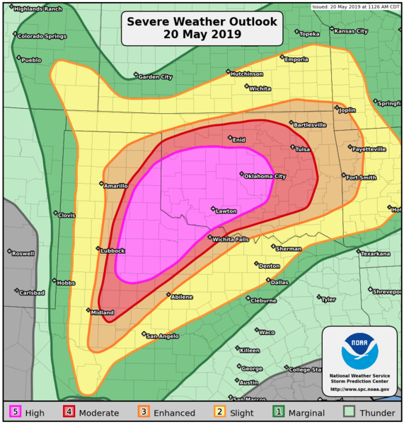
A very dangerous situation is looking more and more likely for the Texas Panhandle into Central Oklahoma, if the paramaters come together like models are currently showing, we could have a large tornado outbreak in this region. A high risk has been issued for a large portion of the region, with a 30% hatched region for tornadoes. On top of that, several rounds of storms could be possible from the early/mid-morning into the overnight hours. Anyone in this region needs to have an plan in place at a moments notice.
- Attachments
-
-
For Your Infinite Source For All Things Weather Visit Our Facebook
-
Belmer

- Global Moderator

- Posts: 745
- Joined: Thu Jan 06, 2011 7:29 pm
- Location: Dallas, TX
- Contact:
Pretty scary situation looks to be unfolding in N. Texas and into Oklahoma. SPC has expanded the 'High' Risk further east now encompassing much of Central OK... including OKC. To make matters worse, there is also a 'High' Risk for Excessive Rainfall in Central OK. A general 4-8 inches looks common, though some models have as much as 12+. Can't recall when I've seen both of these issued over the same area. Very rare...
- SPC High Risk Day 1
- WPC Day 1 Excessive Rainfall
Blake
Boomer Sooner
Boomer Sooner
-
tireman4

- Global Moderator
- Posts: 7120
- Joined: Wed Feb 03, 2010 9:24 pm
- Location: Humble, Texas
- Contact:
Katdaddy and I have a friend who is chasing this week. I ( or he) will try and post photos when she loads them..
- Attachments
-
-
tireman4
- Global Moderator
- Posts: 7120
- Joined: Wed Feb 03, 2010 9:24 pm
- Location: Humble, Texas
- Contact:
This will be an interesting day into tonight. I have never seen values this high...
- Attachments
-
-
tireman4
- Global Moderator
- Posts: 7120
- Joined: Wed Feb 03, 2010 9:24 pm
- Location: Humble, Texas
- Contact:
AFD from Norman OK..
FXUS64 KOUN 201146
AFDOUN
Area Forecast Discussion
National Weather Service Norman OK
646 AM CDT Mon May 20 2019
.DISCUSSION...
The 12Z aviation discussion follows....
&&
.AVIATION...
A warm front over Texas will move north today, probably to near
I-40 around 18Z, to somewhere between I-40 and the OK/KS border
by 00Z. Its position will be influenced significantly by the
evolution of thunderstorms this morning and afternoon, as well as
the extraordinarily strong parent storm system. Numerous
thunderstorms are expected to develop this morning through tonight
over the forecast area, and many of them are expected to be
severe. The TAFs have highlighted with TEMPOs and PROB30s the
expected hours of greatest impact from thunderstorms (though with
relatively low confidence in timing). Most terminals will have
thunderstorms nearby for most of the period after 15Z or so.
Storms should end from west to east between 06Z and about 15Z
tomorrow morning (except storms in northwest Oklahoma may persist
longer than the storms farther south).
CmS
&&
.PREV DISCUSSION... /issued 319 AM CDT Mon May 20 2019/
DISCUSSION...
Widespread and high end severe weather is still expected today
over most of Oklahoma and adjacent parts of northern Texas. The
first wave of at least two today was producing thunderstorms early
this morning in the western TX panhandle. These will continue to
develop east and interact with a diffuse warm front that will
drift north into central Oklahoma later this morning. Very high
instability and very strong vertical shear will persist across
the area today while a second round of supercells are expected
over the TX panhandle that will move east into Oklahoma later this
afternoon and overnight. Very large hail, strong tornadoes and
damaging winds are all expected aided by a strong low-level jet.
Additionally, very heavy rainfall is expected to cause flooding,
particularly from southwest into central and north central
Oklahoma with the several rounds of thunderstorms. The large-
scale wave will exit to the east Tuesday morning after which a
brief period of quiet weather returns. However, another strong
trough moves into the southwestern U.S. Wednesday while lower
layer moisture moves north over the southern plains. Rain and
thunderstorm chances begin Wednesday and last into the weekend.
The focus may be more across the northwestern half of Oklahoma as
a strong upper ridge may limit coverage farther southeast.
&&
.PRELIMINARY POINT TEMPS/POPS...
Oklahoma City OK 76 63 75 59 / 60 80 50 0
Hobart OK 77 60 75 56 / 70 80 10 0
Wichita Falls TX 83 64 78 61 / 60 80 30 0
Gage OK 65 56 74 51 / 80 80 10 0
Ponca City OK 67 64 74 59 / 90 90 60 0
Durant OK 82 65 77 62 / 60 40 80 0
&&
.OUN WATCHES/WARNINGS/ADVISORIES...
OK...Flood Watch through Tuesday afternoon for OKZ004>048-050>052.
TX...Flood Watch through Tuesday afternoon for TXZ083>090.
&&
$$
23/09/23
-
tireman4
- Global Moderator
- Posts: 7120
- Joined: Wed Feb 03, 2010 9:24 pm
- Location: Humble, Texas
- Contact:
Meanwhile, back at the Ranch...
000
FXUS64 KHGX 201128
AFDHGX
Area Forecast Discussion
National Weather Service Houston/Galveston TX
628 AM CDT Mon May 20 2019
.AVIATION...
A smattering of MVFR decks with many hubs coming into sunrise
with VFR few-sct ceilings. All hubs will be VFR by 10 or 11 AM
CDT with a strong gusty southerly wind this afternoon. This strong
lower level uni-directional southeast flow will remain amped up
through Tuesday morning. This will allow for the redevelopment of
a MVFR stratus deck and ultimately be a fog inhibitor. 31
&&
.PREV DISCUSSION... /ISSUED 347 AM CDT Mon May 20 2019/
DISCUSSION...
Southeast Texas is seeing a warm and muggy start to the work week with
3 AM temperatures in the upper 70s to around 80 across much of the area.
Some of these values are close to record high minimum values (see Climate
section below for some more details). A tightening pressure gradient
between high pressure off to our east and deepening low pressure in
the southeast Colorado area will bring increasingly breezy/gusty winds
to much of our area today and tonight. Wind advisories might be needed.
Today`s Southern/Central Plains storm system (see SPC`s Day 1 Convective
Outlook and Public Severe Weather Outlook and also WPC`s Excessive Rainfall
Outlook for details on expected severe thunderstorm/tornado outbreak
and heavy rainfall event) will help to drag a front into our area on
Tuesday. Most Southeast Texas locations will stay dry until the front`s
arrival tomorrow, and expect to see best chance of rain/storms across
our northern counties with this system. This front will also weaken
the pressure gradient resulting in a lowering of winds (especially well
inland) as we head on into Tuesday afternoon. Some lingering rains are
possible Tuesday night across some of our north and northeast counties,
and expect this to be the area`s last best chance of rain for the remainder
of the week and the upcoming weekend as high pressure begins to dominate
the region. It will become occasionally breezy again from the middle
to around the end of the week when surface high pressure builds into
the area from the east. Aloft, mid/upper level ridging also works its
way westward toward the state and helps to bring a rise in high temperatures
along with near zero rain chances. Our primary weather hazard will be
the heat, and precautions should be taken (especially remembering to
never leaving children or pets unattended in vehicles) even though heat
advisories are not anticipated/expected. 42
MARINE...
Lowering northern Mexico and Big Bend region pressure through the
day will re-tighten the regional onshore pressure gradient enough to
produce moderate to strong southeasterlies through a good majority
of the week. The strongest winds will occur over the next 48 hours
with sustained winds in the 20-25 knot range tomorrow night into
early Tuesday morning. Frequent gusts to gale force during this
period has prompted a Gale Watch for all of the Gulf waters. These
strong winds will allow seas to build to a peak Tuesday morning...
average 6 to 8 feet nearshore to near 10 or 11 feet offshore sea
heights with longer periods of 8 or 9 seconds.
Coastal water levels will remain high and, with an early week return
to a strengthened long duration onshore fetch, periodic coastal
flooding will become a concern. 3.5 to 4.0 feet water levels above
MLLW will likely occur during Monday through Thursday`s high tides.
These levels will put water along the low lying streets of the west
end of Galveston Island and may impact the ferry service between
Galveston Island and the west end of the Bolivar Peninsula. Levels
near 4 feet will also push Galveston Bay water onto such eastern
Harris County roads as Toddville Road in Seabrook, and lower
sections of Red Bluff Road between Bay Area Blvd and Highway 146. At
4.0 feet above MLLW, roads along the west shore of Chambers County
will also be impacted. Beaches from San Luis to Surfside can expect
significant wave run up with sections of Beach Drive and the Blue
Water Highway going under water during high tide times. Swimming
conditions will also remain dangerous as rip currents stay strong.
31
CLIMATE...
Some record high minimum temperatures were set again yesterday.
-CLL`s low of 77 degrees tied the record set in 1960
-IAH`s low of 78 degrees tied the record set in 2017
-HOU`s low of 79 degrees set a new record (previous was 78 in 2017)
-GLS`s low of 79 degrees was one degree off the record (80 in 2017)
The area could be dealing with near record high minimum temperatures
for the next several days. Here are the records for today and Tuesday.
CLL - For today, 76 degrees (1990) and for Tuesday, 76 degrees (1990)
IAH - For today, 79 degrees (2011) and for Tuesday, 77 degrees (2013)
HOU - For today, 79 degrees (2011) and for Tuesday, 77 degrees (2011)
GLS - For today, 80 degrees (2017) and for Tuesday, 79 degrees (1990)
42
&&
.PRELIMINARY POINT TEMPS/POPS...
College Station (CLL) 91 75 84 74 92 / 10 10 50 20 10
Houston (IAH) 90 77 89 77 90 / 10 0 30 10 10
Galveston (GLS) 85 78 84 79 85 / 10 10 20 10 10
&&
.HGX WATCHES/WARNINGS/ADVISORIES...
TX...Coastal Flood Advisory until 1 PM CDT Thursday for the following
zones: Brazoria Islands...Galveston Island and Bolivar
Peninsula...Matagorda Islands.
GM...Small Craft Advisory from 7 PM this evening to 1 PM CDT Thursday
for the following zones: Matagorda Bay.
SMALL CRAFT SHOULD EXERCISE CAUTION through this evening for the
following zones: Coastal waters from Freeport to Matagorda
Ship Channel TX out 20 NM...Coastal waters from High Island
to Freeport TX out 20 NM...Galveston Bay...Matagorda Bay...
Waters from Freeport to Matagorda Ship Channel TX from 20
to 60 NM...Waters from High Island to Freeport TX from 20
to 60 NM.
Small Craft Advisory from 7 PM this evening to 7 PM CDT Tuesday
for the following zones: Galveston Bay.
SMALL CRAFT SHOULD EXERCISE CAUTION from Tuesday evening through
Thursday afternoon for the following zones: Galveston Bay.
Gale Watch late tonight for the following zones: Coastal waters
from Freeport to Matagorda Ship Channel TX out 20 NM...
Coastal waters from High Island to Freeport TX out 20 NM...
Waters from Freeport to Matagorda Ship Channel TX from 20
to 60 NM...Waters from High Island to Freeport TX from 20
to 60 NM.
Small Craft Advisory from 7 PM this evening to midnight CDT
tonight for the following zones: Coastal waters from
Freeport to Matagorda Ship Channel TX out 20 NM...Coastal
waters from High Island to Freeport TX out 20 NM...Waters
from Freeport to Matagorda Ship Channel TX from 20 to 60
NM...Waters from High Island to Freeport TX from 20 to 60
NM.
Small Craft Advisory from 6 AM Tuesday to 1 PM CDT Thursday for
the following zones: Coastal waters from Freeport to
Matagorda Ship Channel TX out 20 NM...Coastal waters from
High Island to Freeport TX out 20 NM...Waters from Freeport
to Matagorda Ship Channel TX from 20 to 60 NM...Waters from
High Island to Freeport TX from 20 to 60 NM.
&&
$$
Discussion...42
Aviation/Marine...31
-
javakah
- Posts: 142
- Joined: Thu Jun 02, 2016 9:20 pm
- Location: Fulshear
- Contact:
The tornado chances have been upped again for parts of OK (including OKC) and a bit of the TX panhandle to 45%. YIIIIIKES.
-
unome
- Posts: 3062
- Joined: Fri Feb 12, 2010 6:11 pm
https://twitter.com/NWSSPC/status/1130522603121127425
PUBLIC SEVERE WEATHER OUTLOOK
NWS STORM PREDICTION CENTER NORMAN OK
1214 PM CDT MON MAY 20 2019
...Outbreak of tornadoes and severe thunderstorms expected over
parts of the southern Plains today and tonight...
* LOCATIONS...
Much of Oklahoma
Northwest Texas and the eastern Texas Panhandle
* HAZARDS...
Numerous intense and long-track tornadoes
Widespread damaging winds, some hurricane force
Widespread large hail, some baseball size
* SUMMARY...
An outbreak of tornadoes, some potentially long-track and
violent, is expected today into this evening over portions of
northwest Texas into western and central Oklahoma. More isolated
but still potentially dangerous severe weather, including
tornadoes and destructive winds and hail, is possible in
surrounding parts of Texas, Oklahoma, Kansas, and Arkansas.
Preparedness actions...
Review your severe weather safety procedures for the possibility
of dangerous weather today. Stay tuned to NOAA Weather Radio,
weather.gov, or other media for watches and warnings. A tornado
watch means that conditions are favorable for tornadoes to form
during the next several hours. If a tornado warning is issued for
your area, move to a place of safety, ideally in a basement or
interior room on the lowest floor of a sturdy building.
&&
..Marsh.. 05/20/2019
$$
-
srainhoutx

- Site Admin
- Posts: 19700
- Joined: Tue Feb 02, 2010 2:32 pm
- Location: Maggie Valley, NC
- Contact:
A PDS (Particularly Dangerous Situation) Tornado Watch has been issued for portions of West Texas and the Texas Panhandle until 8 PM
- Attachments
-
Carla/Alicia/Jerry(In The Eye)/Michelle/Charley/Ivan/Dennis/Katrina/Rita/Wilma/Humberto/Ike/Harvey
Member: National Weather Association
Facebook.com/Weather Infinity
Twitter @WeatherInfinity
Member: National Weather Association
Facebook.com/Weather Infinity
Twitter @WeatherInfinity
-
tireman4
- Global Moderator
- Posts: 7120
- Joined: Wed Feb 03, 2010 9:24 pm
- Location: Humble, Texas
- Contact:
@NWSNorman — 12:39 pm - our latest weather balloon data shows the cap is pretty much gone over central Oklahoma. We are starting to see very early signs of storm development in several areas. Storms will get bad quickly. Stay alert!
-
tireman4
- Global Moderator
- Posts: 7120
- Joined: Wed Feb 03, 2010 9:24 pm
- Location: Humble, Texas
- Contact:
US National Weather Service Norman Oklahoma
6 mins ·
1:00 PM update: Severe thunderstorms are expected to rapidly develop between now and 2:00 PM across parts of southwestern Oklahoma. We have a volatile combination of warm muggy unstable air and very strong wind shear, and because of that, any storms that form this afternoon will intensify rapidly and become severe. We expect to issue tornado warnings fairly quickly for any storm that looks like it's a supercell. Storms should become more numerous as we go through the afternoon, and we could be dealing with multiple tornadic storms at the same time by mid to late afternoon. The tornado risk will increase across central Oklahoma after 3:00 PM and continue into the evening.
Stay alert and be safe!
-
tireman4
- Global Moderator
- Posts: 7120
- Joined: Wed Feb 03, 2010 9:24 pm
- Location: Humble, Texas
- Contact:
@Doc_Sanger — Worst-case scenario unfolding for SW/C OK w/many discrete supercells spaced far enough apart to not interfere w/one another later this afternoon. Thus, long-lived, violent tornadoes likely after 2-3 PM until around 8-9 PM, before a line develops.
-
tireman4
- Global Moderator
- Posts: 7120
- Joined: Wed Feb 03, 2010 9:24 pm
- Location: Humble, Texas
- Contact:
@NWSSPC — PDS Tornado Watch # 199 is coming for Oklahoma. This is only the second watch in SPC history where every category of watch probabilities (torn, wind, hail) are at greater than 95%.
The only other watch like this was issued for Alabama on 27 April 2011.
The only other watch like this was issued for Alabama on 27 April 2011.
-
tireman4
- Global Moderator
- Posts: 7120
- Joined: Wed Feb 03, 2010 9:24 pm
- Location: Humble, Texas
- Contact:
@NWSNorman — 2:34 PM - As expected, storms are developing rotation soon after they form. Conditions may change quickly so be alert for warnings and act quickly if you feel threatened.
-
unome
- Posts: 3062
- Joined: Fri Feb 12, 2010 6:11 pm
Hurricane Hunter (Kermit, I think) is flying near Childress right now, as part of TORUS project
https://twitter.com/hashtag/torus19?f=t ... t&src=hash
http://www.tropicalatlantic.com/recon/
http://tropicalatlantic.com/recon/recon ... ing=cesium
https://twitter.com/hashtag/torus19?f=t ... t&src=hash
http://www.tropicalatlantic.com/recon/
http://tropicalatlantic.com/recon/recon ... ing=cesium
-
jasons2k

- Posts: 6192
- Joined: Thu Feb 04, 2010 12:54 pm
- Location: Imperial Oaks
- Contact:
Area Forecast Discussion
National Weather Service Houston/Galveston TX
347 PM CDT Mon May 20 2019
.DISCUSSION...
- Strong southerly winds expected tonight into Tuesday resulting
in rough marine conditions, elevated tides for coastal flooding
especially along Gulf facing beaches, and rip currents. A gale
warning may be needed tonight.
- Capping will be an issue as a line of storms moves into the
area. Storms will likely be weakening and probably more likely a line of showers with a few thunderstorms. This line should slide to the north and east throughout the day.
-
Ptarmigan

- Statistical Specialist

- Posts: 4517
- Joined: Wed Feb 03, 2010 7:20 pm
- Contact:
Houston area was hit by a tornado outbreak on May 20, 1983.
http://www.tornadohistoryproject.com/tornado/1983/5/20
http://www.wxresearch.com/almanac/tornhar.htm
It happened at night as people are asleep. Night time tornadoes are more dangerous as people are asleep.
http://www.tornadohistoryproject.com/tornado/1983/5/20
http://www.wxresearch.com/almanac/tornhar.htm
It happened at night as people are asleep. Night time tornadoes are more dangerous as people are asleep.
-
Katdaddy

- Global Moderator
- Posts: 2521
- Joined: Thu Feb 04, 2010 8:18 am
- Location: League City, Tx
- Contact:
I will always remember the 1983 SE TX May tornado outbreak. I was in 8th grade at the time and ready for Summer. Little did I know the 1983 Summer would bring my first hurricane experience............CAT 3 Hurricane Alicia. To top it off we had record cold in December. 1983 was a quite a weather year for SE TX.
-
Ptarmigan
- Statistical Specialist
- Posts: 4517
- Joined: Wed Feb 03, 2010 7:20 pm
- Contact:
Tornado outbreaks are rare in Houston.Katdaddy wrote: ↑Mon May 20, 2019 7:33 pm I will always remember the 1983 SE TX May tornado outbreak. I was in 8th grade at the time and ready for Summer. Little did I know the 1983 Summer would bring my first hurricane experience............CAT 3 Hurricane Alicia. To top it off we had record cold in December. 1983 was a quite a weather year for SE TX.
1983 started as strong El Nino and ended as a moderate La Nina. The East Pacific was very active, while Atlantic and West Pacific was not as active.