
May 2023
-
Stratton20
- Posts: 5870
- Joined: Tue Feb 09, 2021 11:35 pm
- Location: College Station, Texas
- Contact:
Euro widespread 3-6 inches, absolutely lovely!
-
Iceresistance
- Posts: 580
- Joined: Fri Apr 30, 2021 11:48 pm
- Location: Tecumseh, OK/Norman, OK
- Contact:
-
jasons2k

- Posts: 6201
- Joined: Thu Feb 04, 2010 12:54 pm
- Location: Imperial Oaks
- Contact:
That weather app keeps clinging to those 70% rain chances for today, geez.
-
jasons2k
- Posts: 6201
- Joined: Thu Feb 04, 2010 12:54 pm
- Location: Imperial Oaks
- Contact:
There was an explosion at a Chemical plant near Deer Park. The smoke plume is on radar headed NNE….
-
Cpv17
- Posts: 7109
- Joined: Fri Aug 31, 2018 1:58 pm
- Location: El Campo/Wharton
- Contact:
-
DoctorMu

- Posts: 8089
- Joined: Sun Jun 28, 2015 11:58 am
- Location: College Station
- Contact:
-
Stratton20
- Posts: 5870
- Joined: Tue Feb 09, 2021 11:35 pm
- Location: College Station, Texas
- Contact:
18z GFS now brings the low in land, and has a pretty heavy rain band slowly moving through western se counties
-
dp6
- Posts: 116
- Joined: Sun May 24, 2020 5:32 pm
- Contact:
-
Cpv17
- Posts: 7109
- Joined: Fri Aug 31, 2018 1:58 pm
- Location: El Campo/Wharton
- Contact:
It’s going to be an interesting next few days of model watching.Stratton20 wrote: ↑Fri May 05, 2023 6:05 pm 18z GFS now brings the low in land, and has a pretty heavy rain band slowly moving through western se counties
-
Iceresistance
- Posts: 580
- Joined: Fri Apr 30, 2021 11:48 pm
- Location: Tecumseh, OK/Norman, OK
- Contact:
-
Cpv17
- Posts: 7109
- Joined: Fri Aug 31, 2018 1:58 pm
- Location: El Campo/Wharton
- Contact:
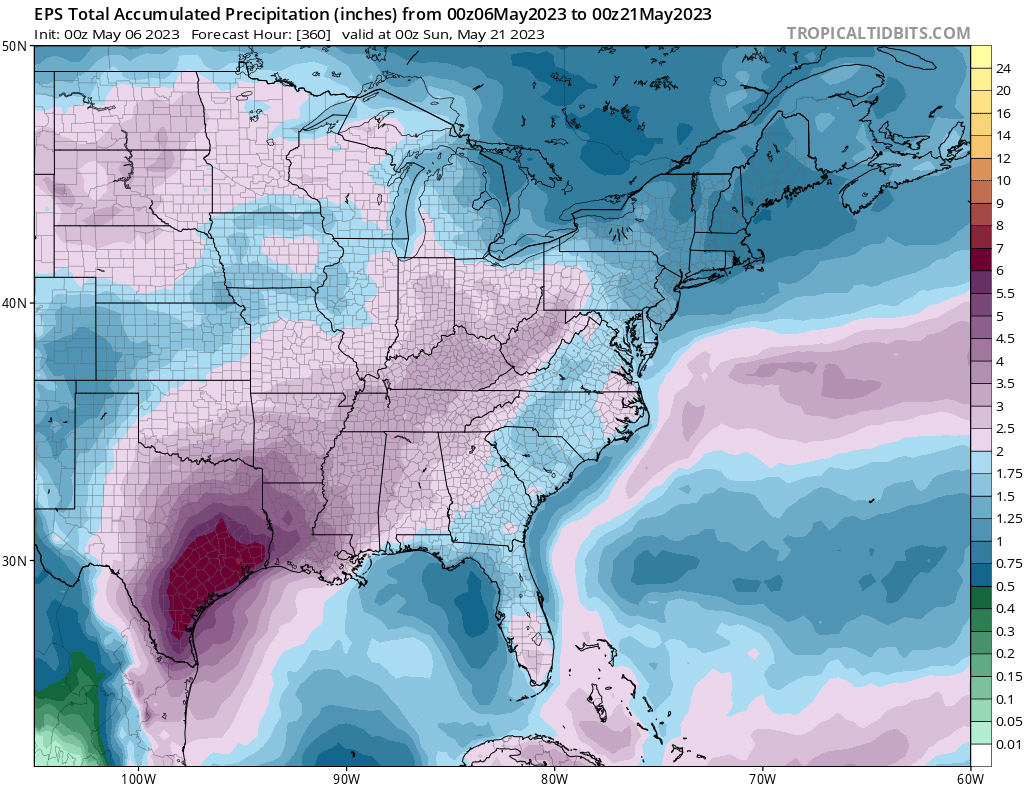
The 12z EPS is still very bullish over southeast TX. It’s now showing 4.5” to 6” over the next 2 weeks.
-
jasons2k
- Posts: 6201
- Joined: Thu Feb 04, 2010 12:54 pm
- Location: Imperial Oaks
- Contact:
-
Cromagnum
- Posts: 3076
- Joined: Thu Feb 03, 2011 10:42 pm
- Location: Georgetown
- Contact:
All mention of rain dropped for tonight.
-
Cpv17
- Posts: 7109
- Joined: Fri Aug 31, 2018 1:58 pm
- Location: El Campo/Wharton
- Contact:
-
MontgomeryCoWx

- Posts: 2753
- Joined: Wed Dec 14, 2011 4:31 pm
- Location: Weimar, TX
- Contact:
I question that daily from April to October but then I remember Houston is one of the few cities left that hasn’t been economically wrecked by Socialists, but it isn’t far away.
Then it will just be a hell hole, literally.
Team #NeverSummer
-
DoctorMu
- Posts: 8089
- Joined: Sun Jun 28, 2015 11:58 am
- Location: College Station
- Contact:
Quite an outflow boundary. Will the cell hold together?!
-
DoctorMu
- Posts: 8089
- Joined: Sun Jun 28, 2015 11:58 am
- Location: College Station
- Contact:
We're already had the wind. Let's have a little rain!
vent: Severe Thunderstorm Warning
Alert:
...A SEVERE THUNDERSTORM WARNING REMAINS IN EFFECT UNTIL 1145 PM CDT
FOR NORTHERN BRAZOS COUNTY...
At 1125 PM CDT, severe thunderstorms were located along a line
extending from 11 miles southeast of Camp Creek Lake to 6 miles
southeast of Kurten to near College Station, moving east at 35 mph.
HAZARD...60 mph wind gusts.
SOURCE...Radar indicated.
IMPACT...Expect damage to roofs, siding, and trees.
Locations impacted include...
Northern College Station, Bryan, Kurten, Wixon Valley and Bryan
Utilities Lake.
HAIL THREAT...RADAR INDICATED
MAX HAIL SIZE...<.75 IN
WIND THREAT...RADAR INDICATED
MAX WIND GUST...60 MPH
Instructions: For your protection move to an interior room on the lowest floor of a building. Wind damage with these storms will occur before any rain or lightning. Do not wait for the sound of thunder before taking cover. SEEK SHELTER IMMEDIATELY inside a sturdy structure and stay away from windows.
Target Area:
Brazos
-
Cpv17
- Posts: 7109
- Joined: Fri Aug 31, 2018 1:58 pm
- Location: El Campo/Wharton
- Contact:
0z Euro and 0z EPS are in great agreement:

-
Stratton20
- Posts: 5870
- Joined: Tue Feb 09, 2021 11:35 pm
- Location: College Station, Texas
- Contact:
Stark difference between the Latest CMC and GFS, GFS has reverted back to its dry solution for SE Texas with only 1-2 inches while the latest CMC opens up the flood gates, widespread 4-8 inches with isolated 12+, but im leaning with the EPS, euro and CMC guidance as they are all pretty much in unanimous agreement for 4-6 inches widespread
- Attachments
-
-
-
Cpv17
- Posts: 7109
- Joined: Fri Aug 31, 2018 1:58 pm
- Location: El Campo/Wharton
- Contact:
That’s an incredible discrepancy between the CMC/Euro vs GFS at this range. This is why you’re not seeing higher rain chances from the NWS or on the local news channels. Till there’s more agreement then they will split the difference between the models and air more on the conservative side. It’s pretty frustrating. Well at least for me lol. The GFS has been pretty inconsistent on location and amounts compared to the others. If I had to make a call right now I’d lean more towards the CMC/Euro.