Page 5 of 37
Re: JUNE 2018 will the rains come?
Posted: Thu Jun 07, 2018 9:19 am
by tireman4
High Temperatures...June 07
Re: JUNE 2018 will the rains come?
Posted: Thu Jun 07, 2018 2:16 pm
by Ounce
Looks like some not slow storms near Ardmore are spreading their wings to the west, as it travels SE.
Re: JUNE 2018 will the rains come?
Posted: Thu Jun 07, 2018 3:48 pm
by GBinGrimes
Been watching that cluster/line ot storms all afternoon. Would be nice if it held together as it crosses the Red River and moves southward.
Re: JUNE 2018 will the rains come?
Posted: Fri Jun 08, 2018 9:31 am
by BlueJay
It's quiet...like the weather.
Re: JUNE 2018 will the rains come?
Posted: Fri Jun 08, 2018 11:05 am
by unome

Area Forecast Discussion
National Weather Service Houston/Galveston TX
1025 AM CDT Fri Jun 8 2018
.DISCUSSION...
Cumulus fields are developing across the region with a few
showers in Jackson county and the nearshore waters. However, with
PWATs in the 1.1 to 1.2 inch range from Fort Bend county to Austin
county and eastward, the best chance for showers this morning
will be for our western counties. A gravity wave is progressing
into the northern zones from Central Texas, which may enhance any
ongoing or developing showers. With no cap in place, we will
continue our pattern of thunderstorm development this afternoon
through this evening. Increased POPs accordingly for areas along
the coast and inland. Otherwise, looks to be yet another hot and
muggy day with high temperatures in the low to mid 90s and lows
tonight in the mid 70s. 22
Re: JUNE 2018 will the rains come?
Posted: Fri Jun 08, 2018 5:21 pm
by srainhoutx
Had an unexpected Seabreeze storm pop up over the house. A couple of CG strikes close by and some brief marble size hail thrown in the boring weather pattern. Looks like a weakness along the Eastern periphery of the Mexico Heat Ridge and possibly TS Bud (currently Invest 92 E) may move that pesky ridge around next week. Fingers crossed. It's getting mighty dry out there.
Re: JUNE 2018 will the rains come?
Posted: Fri Jun 08, 2018 5:39 pm
by unome
yup, rain gods being kind here - no watering this weekend !
http://weather.cod.edu/satrad/nexrad/in ... X-N0Q-1-96
Re: JUNE 2018 will the rains come?
Posted: Fri Jun 08, 2018 5:46 pm
by Scott747
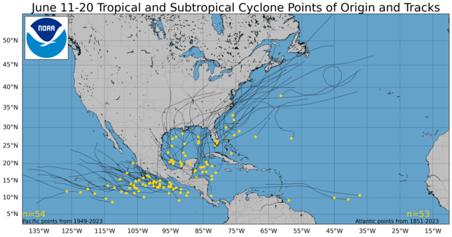
Might be time to keep an eye on the models over the weekend. Right now there is no consensus but a few are suggesting some potential tropical mischief in the central or western gom later next week.
Re: JUNE 2018 will the rains come?
Posted: Fri Jun 08, 2018 6:19 pm
by cperk
The 18Z gfs has a hurricane 961mb coming into what looks like Beaumont and moving due west after landfall.
Re: JUNE 2018 will the rains come?
Posted: Fri Jun 08, 2018 9:03 pm
by sambucol
cperk wrote:The 18Z gfs has a hurricane 961mb coming into what looks like Beaumont and moving due west after landfall.
That would bring rain.

Re: JUNE 2018 will the rains come?
Posted: Fri Jun 08, 2018 10:40 pm
by DoctorMu
cperk wrote:The 18Z gfs has a hurricane 961mb coming into what looks like Beaumont and moving due west after landfall.
Just saw that. 00z loading soon. Whoa - Canadian also has a storm in the Gulf as well...sliding more towards Louisiana.


Re: JUNE 2018 will the rains come?
Posted: Sat Jun 09, 2018 12:40 am
by Texaspirate11
ah...the good ol' gfs
Re: JUNE 2018 will the rains come?
Posted: Sat Jun 09, 2018 9:46 am
by unome
RAMMB/CIRA has had their GOES-East 4 km VIS/IR2 Floater 1 over the Yucatan/Central Am/Wesern Carrib since Thursday morning. Rick Knabb has mentioned this area as a place to watch, climo suggests it as well
http://rammb.cira.colostate.edu/ramsdis ... opical.asp


Re: JUNE 2018 will the rains come?
Posted: Sat Jun 09, 2018 11:12 am
by DoctorMu
Euro has some disturbed weather next week over the Bay of Campeche. Canadian bring a wave into Texas in 8-9 days, GFS for entertainment value right now.
We'll see what the GoM brewmasters have in store over the coming week.
Re: JUNE 2018 will the rains come?
Posted: Sat Jun 09, 2018 12:03 pm
by cperk
DoctorMu wrote:Euro has some disturbed weather next week over the Bay of Campeche. Canadian bring a wave into Texas in 8-9 days, GFS for entertainment value right now.
We'll see what the GoM brewmasters have in store over the coming week.
The 12Z GFS has a cat2 979mb storm coming ashore around Port Arthur and turns due west.
The CMC has a 999mb tropical storm coming ashore south of Corpus.
Re: JUNE 2018 will the rains come?
Posted: Sat Jun 09, 2018 12:43 pm
by srainhoutx
Lot more showers and storms around the area this afternoon. Gusty winds and lightning the biggest threat. Purhaps a bit more aerial coverage tomorrow.
Regarding the "model canes' showing up. Right now conditions are very unfavorable down across Central America with wind sheer running at least 65 kts across the Western/SW Caribbean Sea.
Tropical Weather Outlook
NWS National Hurricane Center Miami FL
200 PM EDT Sat Jun 9 2018
For the North Atlantic...Caribbean Sea and the Gulf of Mexico:
Tropical cyclone formation is not expected during the next 5 days.
$$
Forecaster Zelinsky
Re: JUNE 2018 will the rains come?
Posted: Sat Jun 09, 2018 1:07 pm
by Cromagnum
Hoping to get some rain around Rosharon from these popup storms. Somehow I have managed to be dryslotted on all sides as this crap rotates around us.
Re: JUNE 2018 will the rains come?
Posted: Sat Jun 09, 2018 3:02 pm
by Katdaddy
Not a good afternoon at the Kemah Boardwalk.
BULLETIN - IMMEDIATE BROADCAST REQUESTED
Severe Thunderstorm Warning
National Weather Service Houston/Galveston TX
256 PM CDT SAT JUN 9 2018
The National Weather Service in League City has issued a
* Severe Thunderstorm Warning for...
North central Galveston County in southeastern Texas...
Southeastern Harris County in southeastern Texas...
* Until 330 PM CDT.
* At 255 PM CDT, a severe thunderstorm was located over Kemah
Boardwalk, or over Seabrook, moving northeast at 15 mph.
HAZARD...60 mph wind gusts.
SOURCE...Radar indicated.
IMPACT...Expect damage to roofs, siding, and trees.
* Locations impacted include...
Southeastern Pasadena, northeastern League City, La Porte,
Seabrook, Kemah, Nassau Bay, Taylor Lake Village, El Lago,
Shoreacres, Clear Lake Shores, San Leon and Bacliff.
PRECAUTIONARY/PREPAREDNESS ACTIONS...
For your protection move to an interior room on the lowest floor of a
building.
Torrential rainfall is occurring with this storm, and may lead to
flash flooding. Do not drive your vehicle through flooded roadways.
Re: JUNE 2018 will the rains come?
Posted: Sat Jun 09, 2018 3:40 pm
by srainhoutx
Saturday afternoon briefing from Jeff:
Upper level ridge of high pressure which has helped keep the area generally dry since last Sunday is breaking down and will allow better rain chances for the weekend.
SE TX has been near the eastern edge of the MX upper level ridge this past week and this has generally kept the area hot and dry, but this is starting to change as a weak easterly wave has moved into S TX this afternoon with a surge in higher moisture levels off the Gulf of Mexico. Showers and thunderstorms have been active today along both the inland moving seabreeze and numerous outflow boundaries.
Higher moisture will arrive into the area on Sunday with PWS increasing toward 2.0 inches which during the summer usually spells a wet day for the area. Expect scattered to numerous showers and thunderstorms along the inland moving seabreeze front with main threats being very heavy rainfall and gusty winds.
May see a surge of drier air off the western Gulf of Mexico early next week, but the upper level ridge never builds back overhead and in fact SE TX looks to become situated in a weakness between high pressure cells to our E and our WNW for the next week. Expect daily isolated to scattered showers and thunderstorms along the seabreeze front.
Extended:
A tropical wave looks to move into the Caribbean Sea around the middle of next week and ends up in the western Caribbean Sea by the end of the week. There are various model solutions at the moment as to what may then happen as this feature moves into the Gulf of Mexico next weekend. For now will not favor any one solution over the other as there has been little to no model to model nor run to run consistency when dealing with this feature. Will probably need to start increasing rain chances as early as next Friday as moisture begins to increase as most of the global guidance does agree on that and await better model agreement on what may eventually transpire over the Gulf.
As a reminder…be careful of drawing conclusions from single model runs
Re: JUNE 2018 will the rains come?
Posted: Sat Jun 09, 2018 4:40 pm
by DoctorMu
Cromagnum wrote:Hoping to get some rain around Rosharon from these popup storms. Somehow I have managed to be dryslotted on all sides as this crap rotates around us.
Popcorn showers nearby, but no drops yet. Am enjoying a change of pace from the week's cow skull and tumbleweed-like weather with severe heat and blistering sun!


