
February Weather Discussion. Wild Winter Storms?
-
srainhoutx

- Site Admin

- Posts: 19700
- Joined: Tue Feb 02, 2010 2:32 pm
- Location: Maggie Valley, NC
- Contact:
Good Morning. I see there was a little excitement overnight.  I would not surprised if Advisories/Watches are hoisted into at least Harris County later today.
Carla/Alicia/Jerry(In The Eye)/Michelle/Charley/Ivan/Dennis/Katrina/Rita/Wilma/Humberto/Ike/Harvey
Member: National Weather Association
Facebook.com/Weather Infinity
Twitter @WeatherInfinity
Member: National Weather Association
Facebook.com/Weather Infinity
Twitter @WeatherInfinity
-
srainhoutx
- Site Admin
- Posts: 19700
- Joined: Tue Feb 02, 2010 2:32 pm
- Location: Maggie Valley, NC
- Contact:
Just like the good old days...wxdata wrote:Also, I'm pretty sure Steve and Dan would just wish I'd shut up already, but what would be the fun in that?
Now Tyler, we love you sooooo much!
Carla/Alicia/Jerry(In The Eye)/Michelle/Charley/Ivan/Dennis/Katrina/Rita/Wilma/Humberto/Ike/Harvey
Member: National Weather Association
Facebook.com/Weather Infinity
Twitter @WeatherInfinity
Member: National Weather Association
Facebook.com/Weather Infinity
Twitter @WeatherInfinity
-
hlewis
- Posts: 81
- Joined: Fri Feb 05, 2010 6:29 am
- Location: Wharton County
- Contact:
-
srainhoutx
- Site Admin
- Posts: 19700
- Joined: Tue Feb 02, 2010 2:32 pm
- Location: Maggie Valley, NC
- Contact:
Let's see what the 12Z runs bring. Further shifts in the Watches and any Advisories would come at that point. This will remain a rather fluid situation ALL day IMHO.
Carla/Alicia/Jerry(In The Eye)/Michelle/Charley/Ivan/Dennis/Katrina/Rita/Wilma/Humberto/Ike/Harvey
Member: National Weather Association
Facebook.com/Weather Infinity
Twitter @WeatherInfinity
Member: National Weather Association
Facebook.com/Weather Infinity
Twitter @WeatherInfinity
-
snowman65

- Posts: 1415
- Joined: Thu Feb 04, 2010 6:39 am
- Location: Orange, Tx
- Contact:
Can anyone tell me what to expect around Orange from this system? I am N of I-10 a few miles right on the La border...Thanks!
-
srainhoutx
- Site Admin
- Posts: 19700
- Joined: Tue Feb 02, 2010 2:32 pm
- Location: Maggie Valley, NC
- Contact:
Going to be close for you folks in far SE TX/SW LA. LCH also had a great discussion this morning explaining the same type issues for areas S of I-10 in the Houston Area. Stay Tuned as they say.
Carla/Alicia/Jerry(In The Eye)/Michelle/Charley/Ivan/Dennis/Katrina/Rita/Wilma/Humberto/Ike/Harvey
Member: National Weather Association
Facebook.com/Weather Infinity
Twitter @WeatherInfinity
Member: National Weather Association
Facebook.com/Weather Infinity
Twitter @WeatherInfinity
-
Portastorm

- Posts: 800
- Joined: Wed Feb 03, 2010 3:04 pm
- Location: Southwest Austin/Oak Hill, TX
- Contact:
NWSFO Austin/San Antonio has hoisted a Winter Storm Watch for the AUS area for possible 2-4 inches accumulation of snow!!
I guess they're officially "on board" now with the event.
I guess they're officially "on board" now with the event.
-
hlewis
- Posts: 81
- Joined: Fri Feb 05, 2010 6:29 am
- Location: Wharton County
- Contact:
I will just cry if we don't get 1 flake!! lol The warning is all over the place, except for Wharton County! (oh and a few others)  Would be a great way to cap off the winter!
-
snowman65
- Posts: 1415
- Joined: Thu Feb 04, 2010 6:39 am
- Location: Orange, Tx
- Contact:
Yesterday our local mets mentioned possibility od ra/sn mix Tuesday night. Now they have removed that threat to rain only even though it appears this system may be pushing farther south and may be a little more robust now.........go figure.......
-
brazoria_county22
- Posts: 61
- Joined: Thu Feb 04, 2010 6:39 am
- Location: angleton,tx
- Contact:
good morning khou peeps..just got off of work from working 16 hrs so ive been out of the loop..is there any chance of snow in brazoria county?
-
biggerbyte
- Posts: 1437
- Joined: Thu Feb 04, 2010 12:15 am
- Location: Porter, Texas. (Montgomery County)
- Contact:
Good morning, folks.
Well, we are entering an exciting time in S. E. Texas where we have great potential for some impressive accumulations of snowfall across the area. Impressive, meaning for our area of Texas. Even this morning, it is still a developing situation, however, so no one should expect anything, one way, or the other. That is just the way it is down here.
This is my current thinking. Northern Harris and points north. 2 to 4 inches, with areas surrounding Livingston getting the most. Scattered banding will bring greater totals for some in all of these areas. Areas south of the above mentioned could see 1 to 2 inches. Not sure yet how far south this potential will reach.
Now folks, as with every snow event in this area, we don't know yet how widespread this could be. Don't be surprised if at your house you see a dusting, a flake, or nothing at all, while 50 miles from you they get dumped on. Remember the December event. It could be late tonight, or Tuesday morning even before anyone will know exactly what to expect.
Lastly, this event is a prime example of why many of us in this forum never say never. It is what it is.
Whatever it ends up being, just enjoy the excitement that we rarely see in this area of Texas. This has truly been a wacky winter for so many across the nation even. Pay close attention to the forecast for your county.
Enjoy!
BB
-
wxman57

- Global Moderator

- Posts: 2621
- Joined: Thu Feb 04, 2010 5:34 am
- Location: Southwest Houston (Westbury)
- Contact:
Can you edit your profile to add in your location (city)? It's hard to tell where you are to reference snow possibilities in your area.hlewis wrote:I will just cry if we don't get 1 flake!! lol The warning is all over the place, except for Wharton County! (oh and a few others)
-
hlewis
- Posts: 81
- Joined: Fri Feb 05, 2010 6:29 am
- Location: Wharton County
- Contact:
I'm in the El Campo area, WXMan57.wxman57 wrote:Can you edit your profile to add in your location (city)? It's hard to tell where you are to reference snow possibilities in your area.hlewis wrote:I will just cry if we don't get 1 flake!! lol The warning is all over the place, except for Wharton County! (oh and a few others)
-
srainhoutx
- Site Admin
- Posts: 19700
- Joined: Tue Feb 02, 2010 2:32 pm
- Location: Maggie Valley, NC
- Contact:
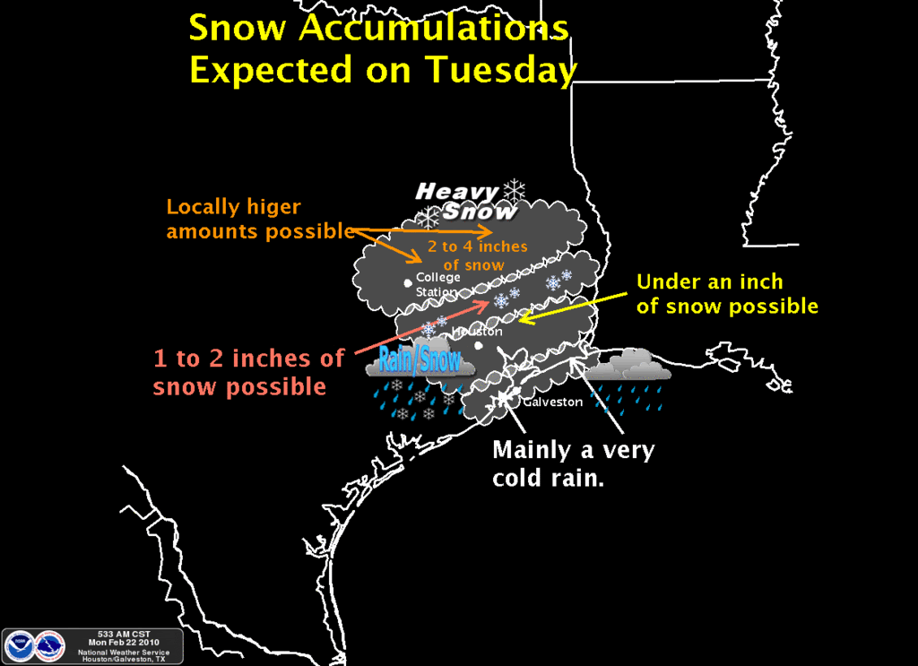
Here is what HGX was thinking this morning...
Carla/Alicia/Jerry(In The Eye)/Michelle/Charley/Ivan/Dennis/Katrina/Rita/Wilma/Humberto/Ike/Harvey
Member: National Weather Association
Facebook.com/Weather Infinity
Twitter @WeatherInfinity
Member: National Weather Association
Facebook.com/Weather Infinity
Twitter @WeatherInfinity
-
ticka1
- Posts: 1265
- Joined: Wed Feb 03, 2010 3:02 pm
- Location: Baytown/Mont Belvieu
- Contact:
Steve is your post a link to a picture? Work blocks pics....just curious what you posted.
-
wxman57
- Global Moderator
- Posts: 2621
- Joined: Thu Feb 04, 2010 5:34 am
- Location: Southwest Houston (Westbury)
- Contact:
The "event" across SE TX will begin in just over 30 hours, and there are still many uncertainties. It still looks like there is an excellent chance that Harris and surrounding counties will see some snow tomorrow late afternoon/evening. That's not really the issue. The issue is whether or not any snow will accumulate on the ground for any length of time. My biggest concern as far as any lasting (more than an hour) accumulations is the relatively high dew points behind the front. Dew points are near 30 around Dallas and mid to upper 30s to our northwest.
The 06Z GFS, the same one that is predicting some accumulating snow here, is forecasting that dew points at IAH when the precip starts tomorrow will be 42F. Now that could be wrong, they could be in the upper 30s, maybe even 36-37. But with dew points that high, there's no room for temperatures to fall (below freezing) by evaporative cooling once the precip starts. That means we'll be completely reliant on advective cooling to get surface temps below freezing so that the snow will not melt shortly after reaching the ground. I just don't think advective cooling is going to cut it. Back on Dec. 4th, our dew points started out in the upper 20s, by the way.
So the current 6z GFS forecasts that the dew point will drop to only 34F by the time the precip ends Tuesday night. That's too warm for any fallen snow to hang around long. But what are the other possibilities, and what might we expect across Houston?
1. The 6Z GFS is quite likely "wrong" as far as our temps and dew points tomorrow afternoon/evening. The odds of it hitting the temp/dew point right exactly on are not high. The model could be wrong on the warm side. That is, the temps near the surface could be colder, allowing snow to stick for longer.
2. Even if the GFS is correct with its forecast of temps/dew points, surfaces like cars and even grass will be colder than the 2m air temperature. This should allow the snow to stick for a while on these surfaces.
Bottom line is I think we will see snow falling all around Harris and surrounding counties. I'm just not sure if the surface temps will be able to drop low enough for it to hang around for more than an hour or two. But we should be happy with that. Let's see what future model runs say. We need to look for a trend (colder or warmer), as we're right on the edge of being cold enough for the snow to hang around until Wednesday morning.
-
brazoria_county22
- Posts: 61
- Joined: Thu Feb 04, 2010 6:39 am
- Location: angleton,tx
- Contact:
wxman57 wrote:The "event" across SE TX will begin in just over 30 hours, and there are still many uncertainties. It still looks like there is an excellent chance that Harris and surrounding counties will see some snow tomorrow late afternoon/evening. That's not really the issue. The issue is whether or not any snow will accumulate on the ground for any length of time. My biggest concern as far as any lasting (more than an hour) accumulations is the relatively high dew points behind the front. Dew points are near 30 around Dallas and mid to upper 30s to our northwest.
The 06Z GFS, the same one that is predicting some accumulating snow here, is forecasting that dew points at IAH when the precip starts tomorrow will be 42F. Now that could be wrong, they could be in the upper 30s, maybe even 36-37. But with dew points that high, there's no room for temperatures to fall (below freezing) by evaporative cooling once the precip starts. That means we'll be completely reliant on advective cooling to get surface temps below freezing so that the snow will not melt shortly after reaching the ground. I just don't think advective cooling is going to cut it. Back on Dec. 4th, our dew points started out in the upper 20s, by the way.
So the current 6z GFS forecasts that the dew point will drop to only 34F by the time the precip ends Tuesday night. That's too warm for any fallen snow to hang around long. But what are the other possibilities, and what might we expect across Houston?
1. The 6Z GFS is quite likely "wrong" as far as our temps and dew points tomorrow afternoon/evening. The odds of it hitting the temp/dew point right exactly on are not high. The model could be wrong on the warm side. That is, the temps near the surface could be colder, allowing snow to stick for longer.
2. Even if the GFS is correct with its forecast of temps/dew points, surfaces like cars and even grass will be colder than the 2m air temperature. This should allow the snow to stick for a while on these surfaces.
Bottom line is I think we will see snow falling all around Harris and surrounding counties. I'm just not sure if the surface temps will be able to drop low enough for it to hang around for more than an hour or two. But we should be happy with that. Let's see what future model runs say. We need to look for a trend (colder or warmer), as we're right on the edge of being cold enough for the snow to hang around until Wednesday morning.
dose that mean brazoria county as well?
-
wxman57
- Global Moderator
- Posts: 2621
- Joined: Thu Feb 04, 2010 5:34 am
- Location: Southwest Houston (Westbury)
- Contact:
That looks reasonable. The snow should hang around long enough to be measured. But if the temps are above freezing, then it'll melt soon after the precip ends.srainhoutx wrote:Here is what HGX was thinking this morning...
http://i228.photobucket.com/albums/ee29 ... nimage.gif
-
srainhoutx
- Site Admin
- Posts: 19700
- Joined: Tue Feb 02, 2010 2:32 pm
- Location: Maggie Valley, NC
- Contact:
Go to the HGX site and click on Tuesday on the Upper Tab Pat.ticka1 wrote:Steve is your post a link to a picture? Work blocks pics....just curious what you posted.
http://www.srh.noaa.gov/hgx/
Carla/Alicia/Jerry(In The Eye)/Michelle/Charley/Ivan/Dennis/Katrina/Rita/Wilma/Humberto/Ike/Harvey
Member: National Weather Association
Facebook.com/Weather Infinity
Twitter @WeatherInfinity
Member: National Weather Association
Facebook.com/Weather Infinity
Twitter @WeatherInfinity
-
wxman57
- Global Moderator
- Posts: 2621
- Joined: Thu Feb 04, 2010 5:34 am
- Location: Southwest Houston (Westbury)
- Contact:
It'll be more of a challenge getting any snow to stick around very long after it touches the ground, but I think you have a good chance of at least seeing it falling.brazoria_county22 wrote:
dose that mean brazoria county as well?