
December Weather Discussion. Will We See Rain?
-
TexasMetBlake
- Pro Met

- Posts: 839
- Joined: Wed Feb 03, 2010 7:03 pm
- Location: Spring/Woodlands
- Contact:
00z shows no wintry weather at all now. Complete reversal. Typical.
-
srainhoutx

- Site Admin

- Posts: 19700
- Joined: Tue Feb 02, 2010 2:32 pm
- Location: Maggie Valley, NC
- Contact:
Good morning. Looking out 240 hours, there are some major model differences...
Carla/Alicia/Jerry(In The Eye)/Michelle/Charley/Ivan/Dennis/Katrina/Rita/Wilma/Humberto/Ike/Harvey
Member: National Weather Association
Facebook.com/Weather Infinity
Twitter @WeatherInfinity
Member: National Weather Association
Facebook.com/Weather Infinity
Twitter @WeatherInfinity
-
wxman57

- Global Moderator

- Posts: 2621
- Joined: Thu Feb 04, 2010 5:34 am
- Location: Southwest Houston (Westbury)
- Contact:
Euro does predict colder air over Texas at 240 hrs than the GFS. Neither indicates anything but cold air, though. Oh, and I don't care about cold air on the 4th now, as our first freeze contest ended this morning. The same guy that appears to have won the hurricane contest with a pick of 19/12/5 picked the 27th as the date of first freeze with a time of 1053Z (it froze at 1153Z). So he wins $200 now.
-
srainhoutx
- Site Admin
- Posts: 19700
- Joined: Tue Feb 02, 2010 2:32 pm
- Location: Maggie Valley, NC
- Contact:
HPC Prelim discussion gives some hints of will likely occur beyond day 5, but even that is a low confidence forecast...
PRELIMINARY EXTENDED FORECAST DISCUSSION
NWS HYDROMETEOROLOGICAL PREDICTION CENTER CAMP SPRINGS MD
812 AM EST SAT NOV 27 2010
VALID 12Z WED DEC 01 2010 - 12Z SAT DEC 04 2010
MEDIUM RANGE MODELS ARE IN GOOD AGREEMENT EARLY IN THE PERIOD THRU
DAY 5 THURS OVER CONUS BUT BEGIN TO DIFFER OVER THE COASTAL EPAC
WITH PAC SHORTWAVE TIMING WITH THE ECMWF HAVING THE FASTEST FLOW
WITH A SHORTWAVE REACHING THE SRN PLAINS DAY 6 FRI WITH CMC IN THE
GREAT BASIN AND GFS JUST COMING INTO THE CA COAST. THESE
DIFFERENCES ALSO SEEN BY ENSEMBLES. 00Z ECMWF ALSO BRINGS THE NEXT
EPAC SHORTWAVE TO THE CA COAST DAY 7 SAT WHILE GFS AND CMS REMAIN
WELL AT SEA. MASSIVE MODEL DIFFERENCES OCCUR INTO DAYS 7 AND 8 AND
9. USING A LAGGED AVERAGE OF THE LAST 4 RUNS OF ECMWF YIELDS A
SOLUTION REASONABLY CLOSE TO A BLEND OF THE 00Z ECMWF ENS MEAN AND
00Z GFS ENS MEAN. LOW CONFIDENCE FORECAST AFTER DAY 5 THURSDAY.
HEAVY FRONTAL RAINS ALONG THE APPLCHNS TUES INTO EASTERN COASTAL
REGIONS WED WITH HEAVIEST RAINFALL INTO THE NORTHEAST WITH LIGHT
SNOW ACROSS THE CENTRAL AND WRN GREAT LAKES REGIONS FOLLOWED BY
THE FIRST DEEP PENETRATION OF COLD AIR INTO THE SOUTH AND MID ATLC
REGIONS WITH FIRST WIDESPREAD FREEZING TEMP POTENTIAL. NEXT PLAINS
STORM MORE UNCERTAIN ON TRACK AND TIMING BUT A LIGHT TO MODERATE
SNOW EVENT POSSIBLE ACROSS THE NRN AND CENTRAL PLAINS DAYS 6 AND 7
FRI/SAT.
Carla/Alicia/Jerry(In The Eye)/Michelle/Charley/Ivan/Dennis/Katrina/Rita/Wilma/Humberto/Ike/Harvey
Member: National Weather Association
Facebook.com/Weather Infinity
Twitter @WeatherInfinity
Member: National Weather Association
Facebook.com/Weather Infinity
Twitter @WeatherInfinity
-
wxman57
- Global Moderator
- Posts: 2621
- Joined: Thu Feb 04, 2010 5:34 am
- Location: Southwest Houston (Westbury)
- Contact:
Last 2-3 runs of the GFS show nothing special in the 10-15 day range. Just a few more cold fronts - one Monday night and probably another a week later.
-
TexasMetBlake
- Pro Met
- Posts: 839
- Joined: Wed Feb 03, 2010 7:03 pm
- Location: Spring/Woodlands
- Contact:
You can't completely rule out the Day 10-15 time range. Back in 2004 at hour 384 on the GFS, showed a snowstorm in Houston for Christmas. NOBODY believed it. 16 days later, it was snowing in Houston (more so Galveston and Victoria). While I have been known to hug models that favor the solution I want to pan out, in this case, the Euro, I have to admit that I think I trust the Euro more during the winter because it seems to have a better handle on the upper-levels than the GFS does. How many AFD's have we read from HGX or DFW that have said, "the gfs shows a massive 30" blizzard for Houston but the Euro only shows cold rain. For now, we're gonna side with the Euro and watch for developing trends. We went with a blend and are calling for a rain snow mix for the area." The wx service seems to ALWAYS side with the Euro on winter events. So keep an eye to the ECMWF and lets hope the solutions only become better and 'wetter' as we move forward into December!
-
srainhoutx
- Site Admin
- Posts: 19700
- Joined: Tue Feb 02, 2010 2:32 pm
- Location: Maggie Valley, NC
- Contact:
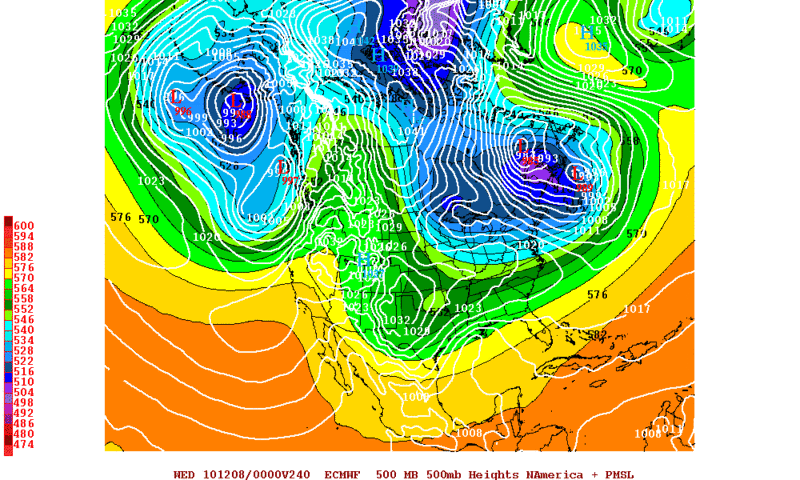
The 12z differences continue with the 12Z run for the GFS and Euro @ 240 hours...
GFS 500mb
Euro 500mb (PSU)
Euro 500mb Operational
GFS 500mb
Euro 500mb (PSU)
Euro 500mb Operational
Carla/Alicia/Jerry(In The Eye)/Michelle/Charley/Ivan/Dennis/Katrina/Rita/Wilma/Humberto/Ike/Harvey
Member: National Weather Association
Facebook.com/Weather Infinity
Twitter @WeatherInfinity
Member: National Weather Association
Facebook.com/Weather Infinity
Twitter @WeatherInfinity
-
Ptarmigan

- Statistical Specialist

- Posts: 4519
- Joined: Wed Feb 03, 2010 7:20 pm
- Contact:
I read that Christmas Eve snow event of 2004 was seen for weeks. Now if the GFS forecast did really panned out and 30 inches snow fell, it would make the 1895 blizzard pale in comparison. I would imagine the 1895 snow event setup was similar to 2004 snow event. Also, it would shut down Houston for weeks.Candy Cane wrote:You can't completely rule out the Day 10-15 time range. Back in 2004 at hour 384 on the GFS, showed a snowstorm in Houston for Christmas. NOBODY believed it. 16 days later, it was snowing in Houston (more so Galveston and Victoria). While I have been known to hug models that favor the solution I want to pan out, in this case, the Euro, I have to admit that I think I trust the Euro more during the winter because it seems to have a better handle on the upper-levels than the GFS does. How many AFD's have we read from HGX or DFW that have said, "the gfs shows a massive 30" blizzard for Houston but the Euro only shows cold rain. For now, we're gonna side with the Euro and watch for developing trends. We went with a blend and are calling for a rain snow mix for the area." The wx service seems to ALWAYS side with the Euro on winter events. So keep an eye to the ECMWF and lets hope the solutions only become better and 'wetter' as we move forward into December!
http://en.wikipedia.org/wiki/2004_Chris ... _snowstorm
http://bayoucityhistory.blogspot.com/20 ... wfall.html
I saw the weather for 1895 and there was a strong high pressure over the Rockies at the time, likely pushing deep cold air from Canada.
February 14, 1895

February 15, 1895

The map does not show a low pressure system, which is likely in the Gulf of Mexico.
Source
http://docs.lib.noaa.gov/rescue/dwm/dat ... _maps.html
Last edited by Ptarmigan on Sat Nov 27, 2010 1:47 pm, edited 1 time in total.
-
TexasMetBlake
- Pro Met
- Posts: 839
- Joined: Wed Feb 03, 2010 7:03 pm
- Location: Spring/Woodlands
- Contact:
Clearly I was exaggerating, Ptarmigan.Ptarmigan wrote:I read that Christmas Eve snow event of 2004 was seen for weeks. Now if the GFS forecast did really panned out and 30 inches snow fell, it would make the 1895 blizzard pale in comparison. I would imagine the 1895 snow event setup was similar to 2004 snow event. Also, it would shut down Houston for weeks.Candy Cane wrote:You can't completely rule out the Day 10-15 time range. Back in 2004 at hour 384 on the GFS, showed a snowstorm in Houston for Christmas. NOBODY believed it. 16 days later, it was snowing in Houston (more so Galveston and Victoria). While I have been known to hug models that favor the solution I want to pan out, in this case, the Euro, I have to admit that I think I trust the Euro more during the winter because it seems to have a better handle on the upper-levels than the GFS does. How many AFD's have we read from HGX or DFW that have said, "the gfs shows a massive 30" blizzard for Houston but the Euro only shows cold rain. For now, we're gonna side with the Euro and watch for developing trends. We went with a blend and are calling for a rain snow mix for the area." The wx service seems to ALWAYS side with the Euro on winter events. So keep an eye to the ECMWF and lets hope the solutions only become better and 'wetter' as we move forward into December!

http://en.wikipedia.org/wiki/2004_Chris ... _snowstorm
http://bayoucityhistory.blogspot.com/20 ... wfall.html
I saw the weather for 1895 and there was a strong high pressure over the Rockies at the time, likely pushing deep cold air from Canada.
http://docs.lib.noaa.gov/rescue/dwm/dat ... _maps.html
-
Ptarmigan
- Statistical Specialist
- Posts: 4519
- Joined: Wed Feb 03, 2010 7:20 pm
- Contact:
It would've been cool to see it.Candy Cane wrote:
Clearly I was exaggerating, Ptarmigan.

-
wxman57
- Global Moderator
- Posts: 2621
- Joined: Thu Feb 04, 2010 5:34 am
- Location: Southwest Houston (Westbury)
- Contact:
Actually, I won a bet on the 2004 snow event. I bet a client that we'd see measurable snow in Houston around Christmas from 2 weeks out. I got a steak dinner out of it. But, of course, we cannot rule out anything 15 days out at this point. However, one single run of the GFS showing possible snow from 2 weeks out isn't enough to convince me it's more than a bad model run. In 2004, the GFS was consistently forecasting snow from 2 weeks out, run after run. And there was support from the Euro as far as the evolving pattern.Candy Cane wrote:You can't completely rule out the Day 10-15 time range. Back in 2004 at hour 384 on the GFS, showed a snowstorm in Houston for Christmas. NOBODY believed it. 16 days later, it was snowing in Houston (more so Galveston and Victoria). While I have been known to hug models that favor the solution I want to pan out, in this case, the Euro, I have to admit that I think I trust the Euro more during the winter because it seems to have a better handle on the upper-levels than the GFS does. How many AFD's have we read from HGX or DFW that have said, "the gfs shows a massive 30" blizzard for Houston but the Euro only shows cold rain. For now, we're gonna side with the Euro and watch for developing trends. We went with a blend and are calling for a rain snow mix for the area." The wx service seems to ALWAYS side with the Euro on winter events. So keep an eye to the ECMWF and lets hope the solutions only become better and 'wetter' as we move forward into December!
The 12Z Euro does show some fairly cold air moving south into Texas on the 7th, along with a strong hint that there may be post-frontal precip on the 8th. But now the GFS is forecasting a much weaker front and no post-frontal precip. The general negative NAO and AO would point to significant cold air intrusions into the U.S. over the next few weeks, so there could be some freezing/frozen precip in Texas the 2nd week of December. I'd just say that chances of anything here appear remote at this point.
-
srainhoutx
- Site Admin
- Posts: 19700
- Joined: Tue Feb 02, 2010 2:32 pm
- Location: Maggie Valley, NC
- Contact:
Another thing that is 'working in our favor' is the blocking pattern across the N Atlantic (Greenland Block). The -NAO continues to be a plus as well and the models keep extending that regime as time has gone on while 'trying' to weaken it. A +PNA would be ideal, but is generally not a La Nina pattern, so more 'help' from the Atlantic would be needed as the Pacific will more than likely not be a friend to those looking for a favorable pattern to bring wintry weather into TX. We will see and the Euro persistence does raise an eyebrow. Also the winter of 1894 was a La Nina winter and records show that snowfall did occur in and near our area in that pattern. 
12Z Euro Ensemble 850mb Temp Anomalies 240 hours...

12Z Euro Ensemble 850mb Temp Anomalies 240 hours...
Carla/Alicia/Jerry(In The Eye)/Michelle/Charley/Ivan/Dennis/Katrina/Rita/Wilma/Humberto/Ike/Harvey
Member: National Weather Association
Facebook.com/Weather Infinity
Twitter @WeatherInfinity
Member: National Weather Association
Facebook.com/Weather Infinity
Twitter @WeatherInfinity
-
Ptarmigan
- Statistical Specialist
- Posts: 4519
- Joined: Wed Feb 03, 2010 7:20 pm
- Contact:
I happen to look at the ENSO data from this link.srainhoutx wrote:Another thing that is 'working in our favor' is the blocking pattern across the N Atlantic (Greenland Block). The -NAO continues to be a plus as well and the models keep extending that regime as time has gone on while 'trying' to weaken it. A +PNA would be ideal, but is generally not a La Nina pattern, so more 'help' from the Atlantic would be needed as the Pacific will more than likely not be a friend to those looking for a favorable pattern to bring wintry weather into TX. We will see and the Euro persistence does raise an eyebrow. Also the winter of 1894 was a La Nina winter and records show that snowfall did occur in and near our area in that pattern.
12Z Euro Ensemble 850mb Temp Anomalies 240 hours...
http://raleighwx.americanwx.com/models/ ... yNA240.gif
ftp://www.coaps.fsu.edu/pub/JMA_SST_Ind ... y.filter-5
1894 -7 -6 -7 -4 -2 -2 -2 -2 -3 -4 -3 -4
1895 -3 -3 -2 -3 -2 1 3 4 7 8 8 6
It shows a Neutral ENSO from 1894-95 winter. The NOAA ENSO data only goes back to 1950 if I recall.
The SOI from 1894-95 shows
http://www.bom.gov.au/climate/current/soihtm1.shtml
1894 17.5 10.0 5.6 -3.0 -5.1 -1.5 -2.3 -5.7 -1.6 1.8 7.2 0.1
1895 5.6 3.0 -0.3 -7.1 -8.2 -4.7 -0.4 -6.3 -4.0 -5.6 -8.6 -3.5
I looked at Cold Tongue Index (CTI), which is Eastern Equatorial Pacific Sea Surface Temperature Anomalies and tied to El Nino.
http://jisao.washington.edu/data_sets/cti/
1894 -44 29 -46 -39 18 -14 64 -8 -1 -50 9 -46
1895 -7 -58 17 26 48 76 33 48 96 87 119 85
Negative Value=La Nina
Positive Value=El Nino
I imagine that the cold snap that gave Houston the blizzard was a very deep freeze like February 1899, December 1983, and December 1989.
-
Mr. T

- Posts: 992
- Joined: Wed Feb 03, 2010 4:22 pm
- Location: Kingwood
- Contact:
The GFS, Euro, and CMC all giving the signal for some Texas snow fun, but unfortunately, the snow is currently forecasted north of Houston
The 0z GFS was very close to giving Houston a chance of a few flakes of snow around the 7th, with any snow to our north and east (snow in Florida ftw). The upper air feature forms a little too far to the east for us...
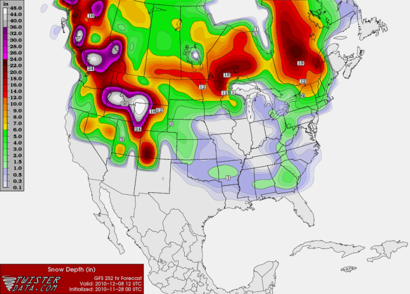
The 0z Euro is fairly interesting. With a 1032 high over N Texas and a coastal low developing, it's probably giving someone some snow in Texas. I wish we had access to Euro QPF maps
And finally, the 0z CMC also has a snowstorm for Oklahoma and North Texas around the 7th of December.
The signal is definitely there for an early December southern snowstorm. No clue who sees what, but it looks like the start of December should be fairly interesting (yet again)
The 0z GFS was very close to giving Houston a chance of a few flakes of snow around the 7th, with any snow to our north and east (snow in Florida ftw). The upper air feature forms a little too far to the east for us...
The 0z Euro is fairly interesting. With a 1032 high over N Texas and a coastal low developing, it's probably giving someone some snow in Texas. I wish we had access to Euro QPF maps
And finally, the 0z CMC also has a snowstorm for Oklahoma and North Texas around the 7th of December.
The signal is definitely there for an early December southern snowstorm. No clue who sees what, but it looks like the start of December should be fairly interesting (yet again)
-
wxman57
- Global Moderator
- Posts: 2621
- Joined: Thu Feb 04, 2010 5:34 am
- Location: Southwest Houston (Westbury)
- Contact:
Note that on that "Twister" snow accumulation graphic above that the area to consider as possible snowfall is typically above 1 inch. Basically, the green contours. The gray contours should be ignored.
-
srainhoutx
- Site Admin
- Posts: 19700
- Joined: Tue Feb 02, 2010 2:32 pm
- Location: Maggie Valley, NC
- Contact:
Taking a look at the overnight Euro Ensemble Mean at 500mb and 850mb temps suggests that we are moving into an interesting period and I suspect some wild swings in the operational runs as well. The HPC does mention the ensembles as the solution they are using at this timeframe due to uncertainties of the Operational models until a sensible solution becomes a bit more clear. With that said, we are beginning to get into a range where the models a seeing a pattern that could bring some wintry weather into the Southern Plains, Deep South as well as the SE CONUS. This pattern certainly bears watching and I suspect activity will only increase as we near the events now being shown via medium and long range guidance.
Norman, OK...
THE COLD AIR LATER IN THE WEEK WILL NEED TO BE MONITORED THOUGH...
AS THERE ARE SIGNS OF A PATTERN CHANGE THAT COULD BRING WINTER
PRECIP TO THE AREA EARLY THE FOLLOWING WEEK. BOTH THE GFS AND THE
ECMWF AMPLIFY AN UPPER RIDGE OVER FAR WESTERN N AMERICA AND
ESTABLISH A LOW OVER NEW ENGLAND. BOTH ALSO HAVE SOME SORT OF
SYSTEM WORKING THROUGH THE SW STATES INTO THE S PLAINS AROUND
NEXT MON-TUE... BY WHICH TIME THEY BOTH ALSO HAVE A SIZEABLE
CANADIAN SFC HIGH SUPPLYING COLD AIR TO MUCH OF THE CONUS E OF THE
ROCKIES. BOTH MODELS SHOW ACCUMULATING SNOW INTO OK MON-TUE - 4-9
INCHES OF IT IN THE CASE OF THE ECMWF. THERE WILL LIKELY BE
SEVERAL SIGNIFICANT SWINGS IN THE MODELS BETWEEN NOW AND THEN...
SO IT IS WAY WAY TOO EARLY TO EVEN TRY TO NAIL DOWN ANY OF
THIS. BUT IT WILL BE WORTH WATCHING IN LATER MODEL RUNS AS WE ARE
ABOUT DUE FOR SOME SORT OF WINTER WEATHER.
Dallas/Ft Worth...
BEYOND NEXT WEEKEND WE WILL HAVE TO WATCH FOR A PERIOD OF COLDER
THAN NORMAL TEMPERATURES. A BLOCKING HIGH IS FORECAST TO DEVELOP
SOUTH OF GREENLAND AND LONGWAVE TROUGHS SHOULD BECOME STATIONARY
ROUGHLY ALONG/OFF EACH COAST OF NORTH AMERICA. THIS SHOULD CREATE
A FAVORABLE ENVIRONMENT FOR A SURFACE HIGH ACROSS CANADA AND THE
US TO GROW IN SIZE/STRENGTH EARLY NEXT WEEK AND SPRAWL SOUTHWARD
INTO THE US. WHILE THIS PATTERN IS NOT LIKELY TO PRODUCE ANY
BITTER OR RECORD COLD HERE...IT IS FAVORABLE FOR A QUIET AND
GRADUAL INFILTRATION OF POLAR AIR FROM THE NORTH AND NORTHEAST
OVER THE COURSE OF A FEW DAYS. THE ECMWF FORECASTS THIS DECLINE IN
TEMPS TO BEGIN WITH A FRONT ON SATURDAY...WHILE THE GFS WAITS
UNTIL MONDAY. EVEN THOUGH THE BROADER UPPER LONGWAVE PATTERN
REMAINS STATIONARY...MODELS DO SHOW AN ACTIVE WEST-EAST JET
ACROSS THE CONUS AND ARE STRUGGLING WITH HOW TO RESOLVE SHORTWAVE
ENERGY COMING IN FROM THE PACIFIC. GFS/ECMWF/GEM AND VARIOUS
ENSEMBLES ARE DISPLAYING ENORMOUS SPREAD BY EARLY NEXT WEEK...AND
THUS TOO EARLY TO DETERMINE WHETHER ANY PRECIPITATION WILL RESULT.
Carla/Alicia/Jerry(In The Eye)/Michelle/Charley/Ivan/Dennis/Katrina/Rita/Wilma/Humberto/Ike/Harvey
Member: National Weather Association
Facebook.com/Weather Infinity
Twitter @WeatherInfinity
Member: National Weather Association
Facebook.com/Weather Infinity
Twitter @WeatherInfinity
-
wxman57
- Global Moderator
- Posts: 2621
- Joined: Thu Feb 04, 2010 5:34 am
- Location: Southwest Houston (Westbury)
- Contact:
Yeah, "interesting", all right. I'd find it more interesting if the Euro was forecasting highs in the mid 90s for early December. It was quite a chilly bike ride yesterday.
Models do indicate some relatively cold air coming south over the next few weeks. Euro remains colder than the GFS. Could even be some frozen stuff across NE TX and OK. There would always be a chance of sleet in SE TX in such airmasses. I don't see anything that would make me want to forecast snow in our area yet. It's just too far out.
Models do indicate some relatively cold air coming south over the next few weeks. Euro remains colder than the GFS. Could even be some frozen stuff across NE TX and OK. There would always be a chance of sleet in SE TX in such airmasses. I don't see anything that would make me want to forecast snow in our area yet. It's just too far out.
-
don

- Posts: 3148
- Joined: Wed Feb 03, 2010 3:33 pm
- Location: Wichita Falls
- Contact:
Yeah I agree, the 0z Euro shows a gulf low with plenty of moisture developing between hours 228 and 240 the problem though is by the time the air gets cold enough down here all the moisture is leaving which seems to often be the case down here, so basically the euro does show a good setup for wintry precip in Texas but only for the panhandle region and Oklahoma. What we want is to see is a system to come through once the cold air is already established and not at the same time the cold air is filtering in.
-
srainhoutx
- Site Admin
- Posts: 19700
- Joined: Tue Feb 02, 2010 2:32 pm
- Location: Maggie Valley, NC
- Contact:
Some interesting developments via the 12Z Operational Euro.
Carla/Alicia/Jerry(In The Eye)/Michelle/Charley/Ivan/Dennis/Katrina/Rita/Wilma/Humberto/Ike/Harvey
Member: National Weather Association
Facebook.com/Weather Infinity
Twitter @WeatherInfinity
Member: National Weather Association
Facebook.com/Weather Infinity
Twitter @WeatherInfinity