
September 2015: Pleasant Weather To End The Month
-
Andrew
- Site Admin

- Posts: 3508
- Joined: Wed Feb 03, 2010 9:46 pm
- Location: North-West Houston
- Contact:
Zoomed in of the ecmwf shows a ~970mb system moving into central and western parts of Louisiana. Still not seeing much from the gfs and even the ecmwf is rather inconsistent on a run by run basis.
- Attachments
-
For Your Infinite Source For All Things Weather Visit Our Facebook
-
wxman57

- Global Moderator

- Posts: 2621
- Joined: Thu Feb 04, 2010 5:34 am
- Location: Southwest Houston (Westbury)
- Contact:
The 12Z Euro as a sub-964mb hurricane moving ashore between Lafayette & Lake Charles around 22Z (5pm) next Friday afternoon. Highly unlikely. Major flip from the 00Z run. GFS indicates 30-40 kts of wind shear across the NW Gulf at that time.
-
srainhoutx

- Site Admin
- Posts: 19700
- Joined: Tue Feb 02, 2010 2:32 pm
- Location: Maggie Valley, NC
- Contact:
The HPC/WPC depicts a surface low along a trough next Tuesday night/early Wednesday SE of Brownsville. The last time we witnessed a cross over from the Gulf of Tehuantepec to the Western Gulf was back in 2010 with TD 11 in the EPAC inpacted the Gulf of Tehuantepec made landfall and brought its mid level energy into the Southwestern Gulf and became TS Hermine.
Carla/Alicia/Jerry(In The Eye)/Michelle/Charley/Ivan/Dennis/Katrina/Rita/Wilma/Humberto/Ike/Harvey
Member: National Weather Association
Facebook.com/Weather Infinity
Twitter @WeatherInfinity
Member: National Weather Association
Facebook.com/Weather Infinity
Twitter @WeatherInfinity
-
wxman57
- Global Moderator
- Posts: 2621
- Joined: Thu Feb 04, 2010 5:34 am
- Location: Southwest Houston (Westbury)
- Contact:
Of course, only 2 of the 50 ECMWF ensemble members indicate a storm in the NW Gulf late next week. The other 48 say "nothing", similar to the GFS. ECMWF control run also says "nothing" next week. I would tend to disregard the 12Z ECMWF deterministic run.
-
Paul Robison
wxman57 wrote:Of course, only 2 of the 50 ECMWF ensemble members indicate a storm in the NW Gulf late next week. The other 48 say "nothing", similar to the GFS. ECMWF control run also says "nothing" next week. I would tend to disregard the 12Z ECMWF deterministic run.
When you say "storm," do you mean a minimal tropical storm or a major wind event like Alicia and Ike were? Why would you disregard the 12Z ECMWF deterministic run?
-
Katdaddy

- Global Moderator
- Posts: 2521
- Joined: Thu Feb 04, 2010 8:18 am
- Location: League City, Tx
- Contact:
Wxman57 just stated why Paul. The other 48 say "nothing", similar to the GFS. Yes with the upcoming pattern there could be slow tropical development in the WGOM. Not every potential results in the worst case scenario and thats why we take it day by day. If a threat becomes serious you will know it. We are family on the KHOU Weather Forum and will work together to keep everyone informed.
-
Paul Robison
BTW, I couldn't help but notice that most of the models showing the low have it hugging the TX coastline before making its final approach to SW LA. I would assume that proximity to land would preclude any development of a serious wind threat, yes?Katdaddy wrote:Wxman57 just stated why Paul. The other 48 say "nothing", similar to the GFS. Yes with the upcoming pattern there could be slow tropical development in the WGOM. Not every potential results in the worst case scenario and thats why we take it day by day. If a threat becomes serious you will know it. We are family on the KHOU Weather Forum and will work together to keep everyone informed.
-
Texaspirate11

- Posts: 1278
- Joined: Tue Dec 31, 2013 12:24 am
- Contact:
Tonights disco HGX NWS
THE 12Z ECMWF IS BACK TRENDING TOWARDS SOME TYPE OF TROPICAL
CYCLONE DEVELOPMENT MONDAY INTO TUESDAY WHERE THE GFS HAS A WEAK
SURFACE LOW IF ANYTHING. THIS SYSTEM THEN TRACKS NORTHWARD INTO
THE NW GULF BY THE MIDDLE OF NEXT WEEK RATHER SLOWLY. THE GFS
SHOWS QUITE A BIT MORE SW SHEAR OVER THE NW GULF DURING THIS TIME
WHERE THE ECMWF HAS WEAKER WSW SHEAR. THE ECMWF HAS BEEN CHANGING
ITS TIMING OF WHEN DEVELOPMENT OCCURS BE IT ON DAY 5 ONE RUN OR
DAY 6-7 ON THE NEXT. THE TRENDS WITH THE ECMWF HAVE BEEN
INCONSISTENT FROM RUN TO RUN BUT HAVE A TROPICAL SIGNAL
NONETHELESS THAT WARRANTS AT LEAST MONITORING. AT THIS POINT ALL
WE CAN REALLY SAY IS THAT THERE ARE A LOT OF QUESTION MARKS FOR
THE DAY 6/7 FORECAST. WE HAVE TO REMEMBER THAT THIS IS JUST ONE
DETERMINISTIC MODEL RUN WITH LITTLE ENSEMBLE SUPPORT. IT DOES LOOK
LIKE A GOOD CHANCE FOR THUNDERSTORMS WITH LOCALLY HEAVY RAINFALL
TUESDAY INTO WEDNESDAY. HIGHEST RAINFALL TOTALS WILL BE ALONG THE
COAST. STRONG WINDS WITH THE SYSTEM OVER THE GULF WILL ELEVATE
TIDE LEVELS AND SURF ALONG THE COAST. OUTSIDE OF THIS IT IS TOO
EARLY IN THE FORECAST PROCESS TO DISCUSS ANY DETAILS IN THE
FORECAST OR IMPACTS. 39
Just because you're disabled, you don't have to be a victim
Be Weather Aware & Prepared!
Barbara Jordan Winner in Media
Disability Integration Consultant
Be Weather Aware & Prepared!
Barbara Jordan Winner in Media
Disability Integration Consultant
-
jeff
- Pro Met

- Posts: 328
- Joined: Wed Feb 10, 2010 5:19 pm
- Contact:
I think we will see something...at least a TD and maybe a TS. It is mid September and a little bit more of an unusual possible track up from the SSW...but has happened before.
Coastal winds will start increasing due to PGF this weekend post front and thus the tides will start to respond. Very low Td air mass moving into the northern Gulf could entrain into the system which I also think will delay the onset of northward moving rainfall early next week. Pattern setup reminds me a lot of TS Frances (98). Differences between the GFS and ECMWF intensities seem to be a result of forecasted wind shear over the NW Gulf.
Track up from the SSW/S could mean a ton of rain or not much at all...a lot of uncertainty.
-
Paul Robison
jeff wrote:I think we will see something...at least a TD and maybe a TS. It is mid September and a little bit more of an unusual possible track up from the SSW...but has happened before.
Coastal winds will start increasing due to PGF this weekend post front and thus the tides will start to respond. Very low Td air mass moving into the northern Gulf could entrain into the system which I also think will delay the onset of northward moving rainfall early next week. Pattern setup reminds me a lot of TS Frances (98). Differences between the GFS and ECMWF intensities seem to be a result of forecasted wind shear over the NW Gulf.
Track up from the SSW/S could mean a ton of rain or not much at all...a lot of uncertainty.
I'd say the solution lies between the two extremes.
-
unome
- Posts: 3062
- Joined: Fri Feb 12, 2010 6:11 pm
from WPC's extended discussion
for the western gulf---
would like to see the canadian take the lead with any 'tropical'
spin---but its actually the ecmwf that likes the bay of campeche
and rio grande delta on day 5 into day 6. and since it's always
been the stronger/faster solution in the southern plains with the
displacement of the upper-level ridge---in the first place---why
not have it be the first with developing some weak cyclonic flow
along the decaying surface boundary. the canadian picks up on the
pattern east of vera cruz after 16/06z and the ecmwf is already
east of brownsville. low level flow (our wpc gridded data)
suggests the south texas coast and hill country are 'open' --- so
at the very least from a sub-synoptic-scale or generic (ensemble
mean) perspective--- should be a nice inverted trough and moisture
plume moving through southeast texas. the day shift/nhc
coordinated a spot low near 23n96w at 15/12z and 25n96w at 16/12z.
that'll work rather nicely with the day6-7 precipitation
projections. and i think the 9/12z gfs/ecmwf and a nnewd track
fits the synoptic pattern upstream/downstream with a moisture
drift towards louisiana day7+ and points northward between 90w-95w
longitude along the western flanks of the downstream surface ridge
invof 35n85w.
vojtesak
7-day WPC loops
http://www.wpc.ncep.noaa.gov/basicwx/day0-7loop.html
http://www.wpc.ncep.noaa.gov/qpf/qpfloop_6hr_d17.html
-
Katdaddy
- Global Moderator
- Posts: 2521
- Joined: Thu Feb 04, 2010 8:18 am
- Location: League City, Tx
- Contact:
Increasing thunderstorm chances this afternoon across SE TX with some locally heavy rains possible as a disturbance approaches from the NW. Additional thunderstorms will develop ahead of cold front tomorrow bringing a taste of Fall for the weekend. Perhaps by Sunday afternoon we will have a slightly better idea regarding any tropical development in the W GOM.
-
BlueJay
- Posts: 938
- Joined: Tue Mar 04, 2014 10:47 am
- Location: Alden Bridge-The Woodlands, Texas
- Contact:
I'm in the "careful what you wish for" mode because we need the rain now. We got about 2.15 inches in August and so far 0.00 inches in September. It's seems it is either feast or famine for us. Hopefully we will get a bit of moisture soon.
-
Kludge

- Posts: 280
- Joined: Wed Feb 03, 2010 11:53 pm
- Location: Montgomery (Walden) TX
- Contact:
AREA FORECAST DISCUSSION
NATIONAL WEATHER SERVICE HOUSTON/GALVESTON TX
951 AM CDT THU SEP 10 2015
MAIN CHANGES TO THE FOREACST WERE TO INCREASE POPS TO AROUND 70
WHERE SHOWER AND THUNDERSTORM ACTIVITY IS OCCURING.
Huh?

NATIONAL WEATHER SERVICE HOUSTON/GALVESTON TX
951 AM CDT THU SEP 10 2015
MAIN CHANGES TO THE FOREACST WERE TO INCREASE POPS TO AROUND 70
WHERE SHOWER AND THUNDERSTORM ACTIVITY IS OCCURING.
Huh?
-
Andrew
- Site Admin
- Posts: 3508
- Joined: Wed Feb 03, 2010 9:46 pm
- Location: North-West Houston
- Contact:
Kludge wrote:AREA FORECAST DISCUSSION
NATIONAL WEATHER SERVICE HOUSTON/GALVESTON TX
951 AM CDT THU SEP 10 2015
MAIN CHANGES TO THE FOREACST WERE TO INCREASE POPS TO AROUND 70
WHERE SHOWER AND THUNDERSTORM ACTIVITY IS OCCURING.
Huh?
Just basic "nowcasting" updates. The NWS just updated rain chances for areas where numerous thunderstorm activity was occuring to 70%.
For Your Infinite Source For All Things Weather Visit Our Facebook
-
srainhoutx
- Site Admin
- Posts: 19700
- Joined: Tue Feb 02, 2010 2:32 pm
- Location: Maggie Valley, NC
- Contact:
FLOOD ADVISORY
NATIONAL WEATHER SERVICE HOUSTON/GALVESTON TX
213 PM CDT THU SEP 10 2015
WALLER TX-MONTGOMERY TX-HARRIS TX-
213 PM CDT THU SEP 10 2015
THE NATIONAL WEATHER SERVICE IN LEAGUE CITY HAS ISSUED A
* URBAN AND SMALL STREAM FLOOD ADVISORY FOR...
NORTHEASTERN WALLER COUNTY IN SOUTHEASTERN TEXAS...
SOUTHERN MONTGOMERY COUNTY IN SOUTHEASTERN TEXAS...
NORTHERN HARRIS COUNTY IN SOUTHEASTERN TEXAS...
* UNTIL 315 PM CDT
* AT 212 PM CDT...DOPPLER RADAR INDICATED HEAVY RAIN DUE TO
THUNDERSTORMS. THIS WILL CAUSE URBAN AND SMALL STREAM FLOODING IN
THE ADVISORY AREA. GENERALLY 1 TO 2 INCHES OF RAIN HAVE FALLEN
WITHIN THE LAST HOUR. THERE ARE ISOLATED AREAS OF 2 TO 3 INCHES OF
RAINFALL IN THE LAST HOUR. STREET FLOODING MAY BE POSSIBLE IN LOW
LYING AREAS AND POOR DRAINAGE AREAS.
* SOME LOCATIONS THAT WILL EXPERIENCE FLOODING INCLUDE...
HUMBLE...TOMBALL...PINEHURST...SPRING...KINGWOOD...THE WOODLANDS...
GREATER GREENSPOINT...HOCKLEY...OAK RIDGE NORTH...SHENANDOAH...
MAGNOLIA...STAGECOACH...BUSH INTERCONTINENTAL AIRPORT...PORTER
HEIGHTS...SPLASHTOWN...HOOKS AIRPORT...THE WOODLANDS PAVILLION...
ATASCOCITA...CHATEAU WOODS AND LAKE HOUSTON.
ADDITIONAL RAINFALL OF 1 INCH IS EXPECTED OVER THE AREA. THIS
ADDITIONAL RAIN WILL MAKE MINOR FLOODING.
Carla/Alicia/Jerry(In The Eye)/Michelle/Charley/Ivan/Dennis/Katrina/Rita/Wilma/Humberto/Ike/Harvey
Member: National Weather Association
Facebook.com/Weather Infinity
Twitter @WeatherInfinity
Member: National Weather Association
Facebook.com/Weather Infinity
Twitter @WeatherInfinity
-
stormlover
- Posts: 439
- Joined: Wed Dec 04, 2013 10:21 am
- Location: Lumberton TX
- Contact:
EURO drops the hurricane idea and heads disturbance in mexico
-
srainhoutx
- Site Admin
- Posts: 19700
- Joined: Tue Feb 02, 2010 2:32 pm
- Location: Maggie Valley, NC
- Contact:
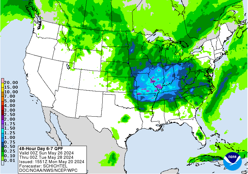
As of this afternoon, the HPC/WPC in coordination with the NHC is leaning on a broad surface low/trough developing Sunday night along the tail end of the frontal boundary.
- Attachments
-
Carla/Alicia/Jerry(In The Eye)/Michelle/Charley/Ivan/Dennis/Katrina/Rita/Wilma/Humberto/Ike/Harvey
Member: National Weather Association
Facebook.com/Weather Infinity
Twitter @WeatherInfinity
Member: National Weather Association
Facebook.com/Weather Infinity
Twitter @WeatherInfinity
-
BlueJay
- Posts: 938
- Joined: Tue Mar 04, 2014 10:47 am
- Location: Alden Bridge-The Woodlands, Texas
- Contact:
.59 inches of rain this afternoon for us.
Whoopee!
Whoopee!
-
Gator
- Posts: 14
- Joined: Mon May 31, 2010 5:05 pm
- Location: Southeast Harris County (between Friendswood & I-45)
- Contact:
We got a solid inch here in Friendswood today (Sep 10) according to my backyard gauge.