
Meaning the track could change again?tireman4 wrote: ↑Thu Jul 11, 2019 12:27 pm [#NerdTweet] Dry air punch & shear from the north doing a number on #Barry's northern half, but now southern convection is important for track.Watch for whether SW quad or SE quad convection dominates next 12 hours. Diabatic vorticity tendency absolutely could nudge the vortex. pic.twitter.com/TZycZL95EB
-- Levi Cowan (@TropicalTidbits) July 11, 2019
July 2019: Warming Trend/Slight Chances For Rain
-
Kingwood36
- Posts: 1592
- Joined: Sat Dec 29, 2018 10:29 am
- Location: Freeport
- Contact:
-
tireman4

- Global Moderator

- Posts: 7122
- Joined: Wed Feb 03, 2010 9:24 pm
- Location: Humble, Texas
- Contact:
Well, who knows. I still think everything is up in the air..there are pros that say yes and there are pros that say no. Interesting times..
-
tireman4
- Global Moderator
- Posts: 7122
- Joined: Wed Feb 03, 2010 9:24 pm
- Location: Humble, Texas
- Contact:
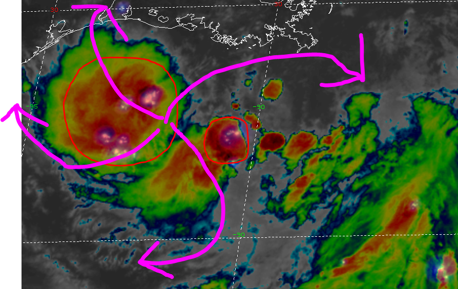
[#NerdTweet] Nowcasting this afternoon involves watching the next meso-vortex to rotate down into the southern semicircle. The last one did not get anchored to any deep convection & amplify. If the next one does, it could precede intensification and/or a SW tug on the circulation pic.twitter.com/abAVAJ9QZs
-- Levi Cowan (@TropicalTidbits) July 11, 2019
-- Levi Cowan (@TropicalTidbits) July 11, 2019
-
djmike

- Posts: 1875
- Joined: Fri Jan 07, 2011 12:19 pm
- Location: BEAUMONT, TX
- Contact:
Cameron Parish issues a "Voluntary order of evacuation" for all areas south of the Intercoastal Waterway as of 12pm 7/11/19.
Mike
Beaumont, TX
(IH-10 & College Street)
Beaumont, TX
(IH-10 & College Street)
-
tireman4
- Global Moderator
- Posts: 7122
- Joined: Wed Feb 03, 2010 9:24 pm
- Location: Humble, Texas
- Contact:
Opinion from a pro at S2K ..we all respect...maybe..just maybe the UKMET was onto something as South Texas Storms ( another pro met..on here and at S2K) states..
Unread postby Aric Dunn » Thu Jul 11, 2019 1:49 pm
Recon flew threw previous center fixes and se to east winds.. so new center is somewhere to the west.. or maybe the larger vort will rotate down and take all the rotational every with it and take hold farther south into convection. If it does add in the fact the trough is no longer digging and barry is in a classic CoL situation would start leading to the ukmet solution.
-
djmike
- Posts: 1875
- Joined: Fri Jan 07, 2011 12:19 pm
- Location: BEAUMONT, TX
- Contact:
If this happens, I will have a LOT of respect for the UK! I have stuck with it from day 1...well, Monday. 
Mike
Beaumont, TX
(IH-10 & College Street)
Beaumont, TX
(IH-10 & College Street)
-
srainhoutx

- Site Admin

- Posts: 19700
- Joined: Tue Feb 02, 2010 2:32 pm
- Location: Maggie Valley, NC
- Contact:
Pretty decent flare up of convection along the West and SW quadrant of the broad surface low. You can see one of the meso vorts being tugged WSW fairly well on visible imagery.
Carla/Alicia/Jerry(In The Eye)/Michelle/Charley/Ivan/Dennis/Katrina/Rita/Wilma/Humberto/Ike/Harvey
Member: National Weather Association
Facebook.com/Weather Infinity
Twitter @WeatherInfinity
Member: National Weather Association
Facebook.com/Weather Infinity
Twitter @WeatherInfinity
-
Rip76

- Posts: 2125
- Joined: Mon Feb 15, 2010 12:38 am
- Location: The Woodlands
- Contact:
srainhoutx wrote: ↑Thu Jul 11, 2019 1:41 pm Pretty decent flare up of convection along the West and SW quadrant of the broad surface low. You can see one of the meso vorts being tugged WSW fairly well on visible imagery.
Can you post the link to this?
-
srainhoutx
- Site Admin
- Posts: 19700
- Joined: Tue Feb 02, 2010 2:32 pm
- Location: Maggie Valley, NC
- Contact:
https://www.tropicaltidbits.com/sat/sat ... roduct=visRip76 wrote: ↑Thu Jul 11, 2019 1:44 pmsrainhoutx wrote: ↑Thu Jul 11, 2019 1:41 pm Pretty decent flare up of convection along the West and SW quadrant of the broad surface low. You can see one of the meso vorts being tugged WSW fairly well on visible imagery.
Can you post the link to this?
Carla/Alicia/Jerry(In The Eye)/Michelle/Charley/Ivan/Dennis/Katrina/Rita/Wilma/Humberto/Ike/Harvey
Member: National Weather Association
Facebook.com/Weather Infinity
Twitter @WeatherInfinity
Member: National Weather Association
Facebook.com/Weather Infinity
Twitter @WeatherInfinity
-
tireman4
- Global Moderator
- Posts: 7122
- Joined: Wed Feb 03, 2010 9:24 pm
- Location: Humble, Texas
- Contact:
And as we speak...the models are still trying to figure this out...again..for entertainment purposes only
https://www.tropicaltidbits.com/stormin ... latest.png
https://www.tropicaltidbits.com/stormin ... latest.png
-
davidiowx
- Posts: 1197
- Joined: Thu Jan 23, 2014 2:39 pm
- Location: Richmond, TX
- Contact:
Looks like that initialized a decent distance east of where the center currently is.. Perhaps that would have a little further west landfall?tireman4 wrote: ↑Thu Jul 11, 2019 1:50 pm And as we speak...the models are still trying to figure this out...again..for entertainment purposes only
https://www.tropicaltidbits.com/stormin ... latest.png
-
tireman4
- Global Moderator
- Posts: 7122
- Joined: Wed Feb 03, 2010 9:24 pm
- Location: Humble, Texas
- Contact:
Boy at this point, who knows David. Maybe Steve and Andrew can answer that better than I can....
-
Pas_Bon
- Posts: 948
- Joined: Tue Sep 11, 2018 7:58 am
- Location: League City, TX
- Contact:
Will Saskatchewan see any effects on its current forecasted track??
-
tireman4
- Global Moderator
- Posts: 7122
- Joined: Wed Feb 03, 2010 9:24 pm
- Location: Humble, Texas
- Contact:
-
tireman4
- Global Moderator
- Posts: 7122
- Joined: Wed Feb 03, 2010 9:24 pm
- Location: Humble, Texas
- Contact:
000
FXUS64 KHGX 111734
AFDHGX
Area Forecast Discussion
National Weather Service Houston/Galveston TX
1234 PM CDT Thu Jul 11 2019
.AVIATION...
Near-term models are still indicating the development of isolated
to widely scattered showers/thunderstorms across parts of the CWA
later this afternoon. Best lift/convergence should be near/closer
to the coast, but did leave the mention of VCTS in for sites from
IAH southward. Any activity that does form should be brief and is
expected to die down around sunset. While not ruling out any more
surprises from the north, did keep with VFR conditions tonight as
the mostly light N/NW flow prevails. 41
&&
-
Rip76
- Posts: 2125
- Joined: Mon Feb 15, 2010 12:38 am
- Location: The Woodlands
- Contact:
Awesome, Thank you.srainhoutx wrote: ↑Thu Jul 11, 2019 1:45 pmhttps://www.tropicaltidbits.com/sat/sat ... roduct=visRip76 wrote: ↑Thu Jul 11, 2019 1:44 pmsrainhoutx wrote: ↑Thu Jul 11, 2019 1:41 pm Pretty decent flare up of convection along the West and SW quadrant of the broad surface low. You can see one of the meso vorts being tugged WSW fairly well on visible imagery.
Can you post the link to this?
-
sau27
- Posts: 415
- Joined: Sat Apr 24, 2010 12:04 am
- Location: Bellaire
- Contact:
Noticing that the center swirl just interected with outflow from the MCS blob off to the west and just blew up some new towers. Don't know what it means for the system (if it will help it grow or choke it). But fun to watch
-
Texaspirate11

- Posts: 1278
- Joined: Tue Dec 31, 2013 12:24 am
- Contact:
UKMET still hellbent on our area...
Just because you're disabled, you don't have to be a victim
Be Weather Aware & Prepared!
Barbara Jordan Winner in Media
Disability Integration Consultant
Be Weather Aware & Prepared!
Barbara Jordan Winner in Media
Disability Integration Consultant
-
Andrew
- Site Admin
- Posts: 3508
- Joined: Wed Feb 03, 2010 9:46 pm
- Location: North-West Houston
- Contact:
What is so interesting to me about the GFS ensembles is the majority of them no longer rotate north and instead continue on a NW path. A very interesting trend that we will have to watch for later this afternoon.
For Your Infinite Source For All Things Weather Visit Our Facebook
-
tireman4
- Global Moderator
- Posts: 7122
- Joined: Wed Feb 03, 2010 9:24 pm
- Location: Humble, Texas
- Contact:
It is either onto something or it is on something..