February 1-5, 2011 Arctic Blast/Winter Storm Discussion

General Weather Discussions and Analysis
Andrew
Site Admin
Site Admin
Posts: 3446
Joined: Wed Feb 03, 2010 9:46 pm
Location: North-West Houston
Contact:

Mr. T wrote:The 0z gfs took a step towards the cmc and euro by taking the Pacific system quicker and further to the south... The gfs misses a full phase by a hair

The bad thing is as far as 850mb heights and surface levels go, even if the GFS makes a full cycle it won't translate to down here. The cold air should be pushing a lot farther south than being shown by the gfs. I hope it jumps on board soon.


Euro text output is running I will update accordingly.
For Your Infinite Source For All Things Weather Visit Our Facebook
User avatar
wxman666
Posts: 519
Joined: Thu Jul 22, 2010 9:02 pm
Location: Cypress, TX
Contact:

Andrew wrote:
Mr. T wrote:The 0z gfs took a step towards the cmc and euro by taking the Pacific system quicker and further to the south... The gfs misses a full phase by a hair

The bad thing is as far as 850mb heights and surface levels go, even if the GFS makes a full cycle it won't translate to down here. The cold air should be pushing a lot farther south than being shown by the gfs. I hope it jumps on board soon.


Euro text output is running I will update accordingly.
It will be interesting to see what the next updates have to offer.
Ready for severe weather season!!
Andrew
Site Admin
Site Admin
Posts: 3446
Joined: Wed Feb 03, 2010 9:46 pm
Location: North-West Houston
Contact:

Euro 00z:

Wed 12z 2m temps: -3C

THU 12Z 03-FEB -5.5C

Very shallow airmass portrayed too.

No snow for IAH or DFW. Looks like a warmer run too.


No wonder I am so confused on the text outputs. This run is crazy. I don't see this verifying at all. If it does that would just suck:

http://www.meteo.psu.edu/~gadomski/ECMW ... floop.html
For Your Infinite Source For All Things Weather Visit Our Facebook
User avatar
Mr. T
Posts: 992
Joined: Wed Feb 03, 2010 4:22 pm
Location: Kingwood
Contact:

Yea. The Euro actually takes the disturbance and pushes it back westward after having a high of 1052+ over Eastern Montana

Really weird run
Andrew
Site Admin
Site Admin
Posts: 3446
Joined: Wed Feb 03, 2010 9:46 pm
Location: North-West Houston
Contact:

Mr. T wrote:Yea. The Euro actually takes the disturbance and pushes it back westward after having a high of 1052+ over Eastern Montana

Really weird run

Omaha gets so much snow houses will disappear :lol:
For Your Infinite Source For All Things Weather Visit Our Facebook
Baseballdude2915
Posts: 192
Joined: Wed Feb 03, 2010 5:21 pm
Location: Dickinson, Tx
Contact:

Hopefully we can all breathe a sigh of relief when the Euro snaps back to its senses at 12z tomorrow.
*Please let this last one be just a bad run*
Andrew
Site Admin
Site Admin
Posts: 3446
Joined: Wed Feb 03, 2010 9:46 pm
Location: North-West Houston
Contact:

Baseballdude2915 wrote:Hopefully we can all breathe a sigh of relief when the Euro snaps back to its senses at 12z tomorrow.
*Please let this last one be just a bad run*

Well as mentioned on other boards this is literally the day after tomorrow run for the North and Northeast.
For Your Infinite Source For All Things Weather Visit Our Facebook
User avatar
srainhoutx
Site Admin
Site Admin
Posts: 19623
Joined: Tue Feb 02, 2010 2:32 pm
Location: Maggie Valley, NC
Contact:

I wouldn't worry too much regarding the Operational runs overnight. Often we see some extreme shifts in the 5-6 day time frame, only to have guidance calm down and return to a sensible solution. The HPC has noted the extreme swings seen overnight and stresses the uncertainties at this time. The Pacific systems (short waves) are causing some havoc and a lot of uncertainty. So far the cold air doesn't seem to be the issue, but timing and strength of those upper air disturbances and how far N or S, elongated or progressive are the big issues, IMO. We will see how all this plays out over the weekend in model world and when we 'see' the cold air mass developing in Canada...


PRELIMINARY EXTENDED FORECAST DISCUSSION
NWS HYDROMETEOROLOGICAL PREDICTION CENTER CAMP SPRINGS MD
359 AM EST FRI JAN 28 2011

VALID 12Z TUE FEB 01 2011 - 12Z FRI FEB 04 2011

MEDIUM RANGE GUIDANCE IS AGREEABLE WITH THE LARGE SCALE SCENARIO
OF AN ELONGATED MEAN TROF EXTENDING FROM NERN CANADA SWWD INTO THE
SWRN CONUS... LIKELY WITH SOME SEPARATION BETWEEN SRN CANADA/NRN
TIER CONUS FLOW AND WRN/SRN CONUS FLOW
.
THIS TROF WILL BE
SUPPORTED BY A MEAN RIDGE THAT SHOULD PERSIST OVER THE ERN PAC/WRN
CANADA ALBEIT WITH SOME CHANGE IN SHAPE OVER TIME.
WHILE A GOOD
CONSENSUS EXISTS WITH THE LARGE SCALE MEAN EVOLUTION... THERE IS
LOWER THAN AVERAGE CONFIDENCE IN DETAILS DUE TO THE SPLIT FLOW
NATURE OF THE NOAM PATTERN AND ADDITIONAL UNCERTAINTIES PRESENTED
BY ERN PAC ENERGY THAT MAY TRY TO PASS THRU THE MEAN RIDGE BY
MID-LATE WEEK.


THE MOST PROMINENT SFC SYSTEM FOR WHICH SHRTWV UNCERTAINTIES COME
INTO PLAY IS FCST TO TRACK NEWD FROM THE SRN PLAINS TUE ONWARD.

TO VARYING DEGREES THE 00Z GFS AND ECMWF HAVE MADE MEANINGFUL NWWD
ADJUSTMENTS FROM FAIRLY SUPPRESSED TRACKS IN MULTIPLE PREVIOUS
RUNS.
THE ECMWF TREND IS MORE EXTREME AS ITS PREVIOUS TWO RUNS
WERE ON THE SERN SIDE OF THE ENVELOPE AND THE NEW 00Z RUN IS NOW
ON THE NWRN SIDE OF GUIDANCE. THE CANADIAN IS A FAST EXTREME TO
BRING SWRN CONUS ENERGY INTO THE PLAINS AND IS ALSO IN THE NWRN
PART OF THE SPREAD... WHILE THE UKMET TRACK IS NOT QUITE AS FAR
NWWD AS ITS PREVIOUS RUN.
OVERALL PREFER A GEFS MEAN/12Z ECMWF
ENSEMBLE MEAN SOLN THAT FALLS IN THE MIDDLE OF LATEST AND RECENT
GUIDANCE GIVEN THE SENSITIVITY OF SHRTWV DETAILS AND SIGNIFICANT
RUN TO RUN CONTINUITY CHANGES.


BEHIND THIS SYSTEM... BY WED NIGHT-FRI THERE IS CONSIDERABLE
SPREAD REGARDING ENERGY THAT MAY TRY TO PASS THRU THE ERN PAC MEAN
RIDGE. THE 00Z ECMWF AND SLOWER 00Z GFS BOTH SEEM A LITTLE STRONG
SO THE ENSEMBLE MEAN BLEND USED FOR THE PLAINS/ERN CONUS SYSTEM
PROVIDES A MORE TOLERABLE SOLN AT THIS TIME. THE GEFS MEAN IS A
LITTLE EXTREME WITH ITS SLOWER TIMING/WWD ELONGATION OF THE TROF
SETTLING OVER THE SWRN CONUS SO INCLUSION OF THE ECMWF MEAN TONES
DOWN THIS ASPECT OF THE FCST.


WHILE DAYS 5-7 WED-FRI FOLLOW A BLEND OF THE GEFS/12Z ECMWF
MEANS... MISSING DATA DUE TO EARLIER COMMS ISSUES PRECLUDED USE OF
THE ECMWF MEAN FOR DAYS 3-4. THUS THE EARLIER PART OF THE FCST
STARTED WITH A BLEND OF GFS/ECMWF/GEFS MEAN SOLNS TO ARRIVE AT AN
ACCEPTABLE COMPROMISE.


RAUSCH

Image
Carla/Alicia/Jerry(In The Eye)/Michelle/Charley/Ivan/Dennis/Katrina/Rita/Wilma/Humberto/Ike/Harvey

Member: National Weather Association
Facebook.com/Weather Infinity
Twitter @WeatherInfinity
jabcwb2
Posts: 181
Joined: Thu Feb 04, 2010 5:43 am
Location: Tomball, Texas
Contact:

I was just looking at "other" local stations online weather forecasts - they are showing next Tues/Wed temps as being warmer! :lol:
randybpt
Posts: 114
Joined: Thu Feb 04, 2010 11:20 am
Contact:

Well if the arctic air is suppost to be as cold as some advertise on here I don't understand why not one official forecast mentions it. BPT. Has highs in 60's and 50's next week not even close to freezing. I don't see any cold air moving into any source region that normally. Gives us. True arctic fronts
User avatar
srainhoutx
Site Admin
Site Admin
Posts: 19623
Joined: Tue Feb 02, 2010 2:32 pm
Location: Maggie Valley, NC
Contact:

And just for fun, the 06Z GFS says we'll be doing this again near February 11th...
Carla/Alicia/Jerry(In The Eye)/Michelle/Charley/Ivan/Dennis/Katrina/Rita/Wilma/Humberto/Ike/Harvey

Member: National Weather Association
Facebook.com/Weather Infinity
Twitter @WeatherInfinity
User avatar
cristina99
Posts: 125
Joined: Fri Jan 21, 2011 2:33 pm
Location: The Woodlands / Spring / Conroe
Contact:

good morning. Watching David Paul as I get ready for work and he FINALLY mentions the very cold air and a chance for sleet or snow - but like one of the other posters, the temps are a bit warmer. I am geting excited now. I can't wait. :D
MRG93415
Posts: 123
Joined: Fri Apr 23, 2010 3:36 pm
Location: Cypress, TX
Contact:

I have a question.....If the temps are going to be cold like in the 20's, when will the stations start to announce this? I know everyone on here is waiting on models and so on but shouldnt people be on alert for wrapping pipes and taking care of plants and so forth. I am in the far NW of HOuston almost on the border of Harris and Waller county and it is always colder here then in HOuston proper. Sunday might we extremly wet and not a good day to try and wrap up pipes..LOL Just wondering if we should take precaustions now or is there going to be enough of a warning to do so?
User avatar
srainhoutx
Site Admin
Site Admin
Posts: 19623
Joined: Tue Feb 02, 2010 2:32 pm
Location: Maggie Valley, NC
Contact:

HGX has finally updated an here is what they are thinking...

AREA FORECAST DISCUSSION
NATIONAL WEATHER SERVICE HOUSTON/GALVESTON TX
550 AM CST FRI JAN 28 2011

.DISCUSSION...
SOUTHERN BRANCH BRINGING CIRRUS TO THE REGION THIS MORNING AND
SHOULD MOST OF THE MORNING. A VERY PLEASANT DAY WILL BE ON TAP.
UPPER LOW WEST OF BAJA WILL START MOVING EAST AND WILL TAP INTO
RATHER RICH GULF MOISTURE SATURDAY. MODEL SOUNDINGS INDICATE A
RAPID INCREASE IN MID AND HIGH CLOUDS DURING THE MORNING SATURDAY
AND THEN LL MOISTURE RAMPS UP QUICKLY DURING THE AFTERNOON WITH
RAIN CHANCES INCREASING QUICKLY DURING THE AFTERNOON AS WELL FROM
WEST TO EAST. ISOLATED THUNDERSTORMS POSSIBLE. SATURDAY NIGHT
LOOKING WET AS 1-1.4" PW ARRIVE WITH THE S/W SWEEPING THROUGH
AROUND SUNRISE...HIGH POPS ARE IN ORDER. MODERATE WAA IN
PLACE...INSTABILITY WILL BE SLIM BUT LI OF 0 TO -2 POSSIBLE/CAPE
LESS THAN 400 J/KG. THE NAM/GFS/ECMWF ALL DISAGREE ON THE TRACK OF
THE HEAVIEST RAIN AMOUNTS...GFS HITS THE NORTHERN CWA HARD AROUND
06Z SUN...ECMWF NORTHWEST TO THE SOUTHEAST 06-15Z (AND WITH BETTER
INSTABILITY) AND THE NAM CENTRAL 8-18Z. IN THIS FORECAST HAVE
FAVORED THE HEAVIER PRECIP OVER THE CENTRAL AND SOUTHERN AFTER
MIDNIGHT. RAINS SHOULD BE TAPERING OFF IN THE MORNING AND LIKELY
BY 10 AM FOR THE HOUSTON AREA BUT AREAS TO THE EAST MAY STILL HAVE
SHRA THROUGH EARLY AFTERNOON. SOME LINGERING INSTABILITY WITH
DAYTIME HEATING BUT SUBSIDENCE IN THE WAKE OF THE LOW SHOULD
INHIBIT ANY LATE AFTERNOON DEVELOPMENT.

MONDAY SHOULD BE WARM WITH A WARM FRONT MOVING BACK NORTH INTO THE
AREA WITH CLOUDS AND POSSIBLY SOME MORE SHOWERS. AN VERY COLD
AIRMASS WILL BE PLUNGING SOUTH THROUGH THE PLAINS AND SHOULD BE
NEAR THE RED RIVER AROUND 00Z TUESDAY WITH THE FRONT COMING
THROUGH SETX TUESDAY AFTERNOON OR EARLY EVENING.


CONFIDENCE DROPS VERY QUICKLY AFTER THE FRONT GOES THROUGH. AT
PRESENT AM EXPECTING THE AIRMASS TO DRY OUT BUT WITH CLOUD COVER
LINGERING WEDNESDAY AND POSSIBLY THURSDAY. THE ECMWF IS MUCH
COOLER THAN THE GFS. WAS INITIALLY INCLINED TO FOLLOW THE ECMWF
BUT WITH THE BIG WAFFLE IN THE FORECAST TRACK OF THE LOW ON
TUESDAY HAS LOWERED CONFIDENCE HUGELY. TEMPERATURES IN THE 20S AND
30S WILL BE LIKELY BUT WILL WEDNESDAY MORNING OR THURSDAY MORNING
BE THE COLDEST--PROBABLY THURSDAY BUT IT COULD END UP BEING FRIDAY
IF THE ECMWF IS CORRECT. BROAD UPPER LOW TUESDAY NIGHT OVER
COLORADO GETS STRETCHED OUT TO THE EAST AND MODEL SOLUTIONS ARE
ALL OVER THE PLACE. A SECOND ISSUE IS HOW FAR SOUTH ANY FROZEN
PRECIP WILL GET. PREVIOUS RUNS WERE INDICATING SNOW COULD GET AS
FAR SOUTH AS I-10 BUT CURRENT SUITE OF 00Z RUNS KEEPS IT WELL
NORTH OF THE REGION. SO FOR NOW WILL NOT MENTION ANY IN THE
FORECAST BUT THIS IS MOVING TARGET.
STAY TUNED
Carla/Alicia/Jerry(In The Eye)/Michelle/Charley/Ivan/Dennis/Katrina/Rita/Wilma/Humberto/Ike/Harvey

Member: National Weather Association
Facebook.com/Weather Infinity
Twitter @WeatherInfinity
User avatar
wxman57
Global Moderator
Global Moderator
Posts: 2621
Joined: Thu Feb 04, 2010 5:34 am
Location: Southwest Houston (Westbury)
Contact:

Well, those overnight model runs really cleared things up, didn't they? Considerably warmer for the Euro in the 00Z run (about +14C at 850mb). I guess we'll have to wait until Sunday or Monday to really have a good handle on Tuesday or Wednesday.
randybpt
Posts: 114
Joined: Thu Feb 04, 2010 11:20 am
Contact:

I still don't see any bitter cold in nw canada there is some in ne canada but never seen our arctic fronts come from there. Im willing to bet steak dinner we will not get hard freeze and highs in 30' s this week seems to be just another cool dreary week.
Andrew
Site Admin
Site Admin
Posts: 3446
Joined: Wed Feb 03, 2010 9:46 pm
Location: North-West Houston
Contact:

randybpt wrote:I still don't see any bitter cold in nw canada there is some in ne canada but never seen our arctic fronts come from there. Im willing to bet steak dinner we will not get hard freeze and highs in 30' s this week seems to be just another cool dreary week.

Ill take that bet any day. 89 had the cold source from that region and it filtered west to come south. That is what is going to happen this time too. So where should I go for my steak dinner?

Oh and for hard freeze lets get specifics down do you want to go by the Houston NWS of a hard freeze? Or do you have a specific number you were thinking?
For Your Infinite Source For All Things Weather Visit Our Facebook
PaulEInHouston
Posts: 100
Joined: Sat Jan 08, 2011 6:59 am
Location: League City
Contact:

wxman57 wrote:Well, those overnight model runs really cleared things up, didn't they? Considerably warmer for the Euro in the 00Z run (about +14C at 850mb). I guess we'll have to wait until Sunday or Monday to really have a good handle on Tuesday or Wednesday.
Models flopping around like a fish out of water. :lol: For what it's worth, my "guess" is the "coldest" air arrives mid-late week. As for precip, overrunning pattern to entice us with clouds with a possible lower Texas or mid Texas coastal low and/or SW that everyone follows with cross fingers/toes from the Baja area.
User avatar
srainhoutx
Site Admin
Site Admin
Posts: 19623
Joined: Tue Feb 02, 2010 2:32 pm
Location: Maggie Valley, NC
Contact:

wxman57 wrote:Well, those overnight model runs really cleared things up, didn't they? Considerably warmer for the Euro in the 00Z run (about +14C at 850mb). I guess we'll have to wait until Sunday or Monday to really have a good handle on Tuesday or Wednesday.

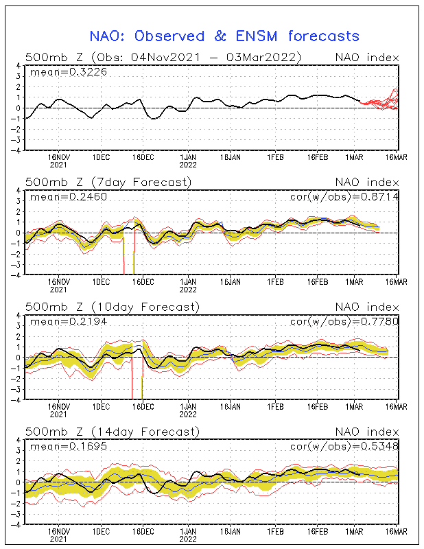
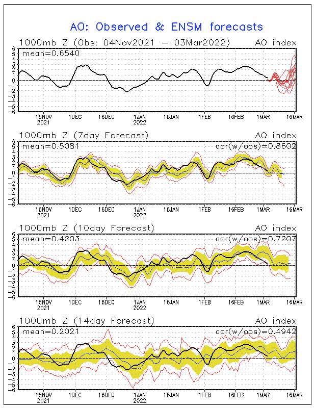
Yep. As clear as mud. This sort of reminds me of the Post Christmas EC storm where the models sent the storm out to sea to only bring that storm back closer to the EC within 48 hours. There does some seem to be a theme this season regarding guidance struggling right up to the event. You have to love these transitions with NAO/AO telecommunications. Always a challenge, it seems.

Image

Image
Carla/Alicia/Jerry(In The Eye)/Michelle/Charley/Ivan/Dennis/Katrina/Rita/Wilma/Humberto/Ike/Harvey

Member: National Weather Association
Facebook.com/Weather Infinity
Twitter @WeatherInfinity
User avatar
srainhoutx
Site Admin
Site Admin
Posts: 19623
Joined: Tue Feb 02, 2010 2:32 pm
Location: Maggie Valley, NC
Contact:

Where is that cold air mass? Here it is heading S from the N Pole...

Code: Select all

Conditions Temp (°C) Humidity (%) Dew Point (°C) Wind (km/h) Pressure (kPa) Wind Chill  
Alert Airport  28 Jan 2011 9:00 EST 
N/A -37 68 -40 E 5 101.0 -44 
Arviat Airport  28 Jan 2011 8:00 CST 
Blowing Snow -33 64 -37 N 41 102.0 -52 
Baker Lake Airport  28 Jan 2011 8:14 CST 
Blowing Snow -39 67 -43 NW 52 gust 63 100.0 -62 
Brevoort Island  28 Jan 2011 9:13 EST 
Light Snow -24 N/A N/A N/A 100.0 N/A  
Cam Four  28 Jan 2011 8:00 CST 
N/A -42 N/A N/A N/A N/A N/A  
Cambridge Bay Airport  28 Jan 2011 7:11 MST 
Blowing Snow -38 67 -42 NW 32 100.0 -57 
Cape Dorset Airport  28 Jan 2011 9:00 EST 
Light Snow -21 75 -24 W 32 gust 41 100.5 -34 
Cape Dyer  28 Jan 2011 9:13 EST 
N/A N/A N/A N/A SSW 17 N/A N/A  
Cape Hooper  28 Jan 2011 9:00 EST 
N/A -27 N/A N/A WSW 76 99.6 -48 
Cape Mercy  28 Jan 2011 9:00 EST 
N/A -25 N/A N/A WSW 54 gust 65 100.1 -43 
Cape Peel West  28 Jan 2011 7:00 MST 
N/A -38 N/A N/A N/A 103.1 N/A  
Chesterfield Inlet Airport  28 Jan 2011 8:00 CST 
Blowing Snow -35 52 -41 NW 46 gust 55 N/A -55 
Clyde Airport  28 Jan 2011 9:00 EST 
Clear -30 68 -34 calm 99.7 N/A  
Consul Lake  28 Jan 2011 7:00 CST 
N/A -37 69 -41 NNW 30 103.0 -55 
Coral Harbour Airport  28 Jan 2011 9:00 EST 
Ice Crystals -31 76 -34 NNW 39 100.5 -49 
Croker River  28 Jan 2011 7:00 MST 
N/A -34 N/A N/A SSW 8 103.6 -43 
Ennadai Lake  28 Jan 2011 7:00 MST 
N/A -30 78 -33 44 102.2 -48 
Eureka  28 Jan 2011 8:00 CST 
Ice Crystals -42 67 -46 calm 101.1 N/A  
Gjoa Haven Airport  28 Jan 2011 7:00 MST 
N/A -40 65 -44 NW 30 gust 45 101.8 -59 
Grise Fiord Airport  28 Jan 2011 9:00 EST 
Mainly Clear -35 71 -39 ESE 5 100.4 -41 
Hall Beach Airport  28 Jan 2011 9:00 EST 
Blowing Snow -38 61 -42 WNW 33 100.0 -57 
Hat Island  28 Jan 2011 7:00 MST 
N/A -38 N/A N/A N/A 102.4 N/A  
Igloolik Airport  28 Jan 2011 9:00 EST 
Blowing Snow -38 N/A N/A WNW 37 99.9 -58 
Iqaluit Airport  28 Jan 2011 9:00 EST 
Ice Crystals -28 68 -32 ENE 5 101.0 -33 
Kimmirut Airport  28 Jan 2011 9:00 EST 
Partly Cloudy -29 53 -36 NNE 11 101.1 -38 
Kugaaruk Airport  28 Jan 2011 7:00 MST 
Light Snow -40 N/A N/A W 26 gust 42 101.1 -58 
Kugluktuk Airport  28 Jan 2011 7:00 MST 
Ice Crystals -36 71 -39 SW 18 103.7 -50 
Longstaff Bluff  28 Jan 2011 9:00 EST 
N/A -31 N/A N/A SE 30 99.8 -47 
Pangnirtung Airport  28 Jan 2011 9:00 EST 
Mainly Sunny -28 57 -34 calm 100.7 N/A  
Pond Inlet Airport  28 Jan 2011 9:12 EST 
Cloudy -30 66 -34 S 8 99.7 -38 
Qikiqtarjuaq Airport  28 Jan 2011 9:00 EST 
Ice Crystals -28 70 -32 S 11 100.0 -37 
Rankin Inlet Airport  28 Jan 2011 8:00 CST 
Blowing Snow -37 68 -40 N 48 gust 58 101.7 -58 
Repulse Bay Airport  28 Jan 2011 8:00 CST 
Blowing Snow -36 70 -40 NNW 21 gust 35 100.9 -51 
Resolute Airport  28 Jan 2011 8:00 CST 
Ice Crystals -41 70 -44 NNW 37 101.0 -62 
Resolution Island  28 Jan 2011 9:00 EST 
N/A -21 N/A N/A N/A 101.0 N/A  
Rowley Island  28 Jan 2011 9:00 EST 
N/A -33 N/A N/A W 33 N/A -50 
Sanikiluaq Airport  28 Jan 2011 9:00 EST 
Ice Crystals -29 75 -32 NNW 5 102.0 -34 
Shepherd Bay Airport  28 Jan 2011 7:00 MST 
Light Snow -40 N/A N/A N/A 101.4 N/A  
Stefansson Island  28 Jan 2011 8:00 CST 
N/A -38 66 -42 W 23 102.0 -54 
Wager Bay  28 Jan 2011 7:00 CST 
N/A -35 68 -39 WNW 43 101.4 -55 
Whale Cove Airport  28 Jan 2011 8:00 CST 
Blowing Snow -36 31 -47 NW 33 101.8 -54 
Carla/Alicia/Jerry(In The Eye)/Michelle/Charley/Ivan/Dennis/Katrina/Rita/Wilma/Humberto/Ike/Harvey

Member: National Weather Association
Facebook.com/Weather Infinity
Twitter @WeatherInfinity
Post Reply
  • Information
  • Who is online

    Users browsing this forum: Ahrefs [Bot] and 14 guests