September 2020:
-
Scott747
- Posts: 1647
- Joined: Tue Feb 23, 2010 9:56 am
- Location: Freeport/Surfside Beach
- Contact:
Ejecting quickly out to the NE along the coast into sw la Thursday afternoon.
-
Scott747
- Posts: 1647
- Joined: Tue Feb 23, 2010 9:56 am
- Location: Freeport/Surfside Beach
- Contact:
12z Ukie is further west compared to the 0z run. Nears Baffin Bay before stalling and quickly lifting out to the NE.
-
Scott747
- Posts: 1647
- Joined: Tue Feb 23, 2010 9:56 am
- Location: Freeport/Surfside Beach
- Contact:
Bookmark that 12z GFS run. Doubt you will ever see something that perfectly traverses the entire and immediate Texas coast as a hurricane like that.
Last edited by Scott747 on Fri Sep 18, 2020 11:44 am, edited 1 time in total.
-
davidiowx
- Posts: 1190
- Joined: Thu Jan 23, 2014 2:39 pm
- Location: Richmond, TX
- Contact:
Welp whatever this becomes, it will be named Beta now that Alpha was just designated wayyyyy out there in the Atlantic near Portugal.
-
TexasBreeze
- Posts: 1024
- Joined: Sun Sep 26, 2010 4:46 pm
- Location: NW Houston, TX
- Contact:
Already into the Greeks, didn't take long! There was lots of back and forth on other sites about naming that little Portugal system since yesterday.
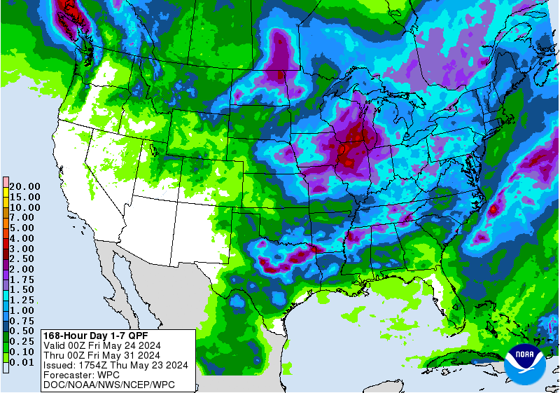
Soon to be "Beta" will be offshore TX this coming week.
Soon to be "Beta" will be offshore TX this coming week.
-
Cpv17
- Posts: 7021
- Joined: Fri Aug 31, 2018 1:58 pm
- Location: El Campo/Wharton
- Contact:
57 seems pretty confident this won’t impact us much over on storm2k lol hard to believe at this point.
-
Cpv17
- Posts: 7021
- Joined: Fri Aug 31, 2018 1:58 pm
- Location: El Campo/Wharton
- Contact:
Yeah, but hardly any rain inland? Weird. I guess everything is sheared off to the east or something. I mean I know the east side is the dirty side but I would think you would get more rain on the north side of the system than it just showed on the GFS.
- Rip76
- Posts: 2111
- Joined: Mon Feb 15, 2010 12:38 am
- Location: The Woodlands
- Contact:
-
Cpv17
- Posts: 7021
- Joined: Fri Aug 31, 2018 1:58 pm
- Location: El Campo/Wharton
- Contact:
I think he believes there will be a lot of dry air ingested into the system from the north so the north side of the system won’t have much precip?
-
davidiowx
- Posts: 1190
- Joined: Thu Jan 23, 2014 2:39 pm
- Location: Richmond, TX
- Contact:
I do think there will be a very sharp gradient where the rain falls where it does not fall. That line could line up anywhere from offshore to further inland. Time will tell how far the trough can dig, its hard to predict how far they advance, especially this time of year.
-
Cpv17
- Posts: 7021
- Joined: Fri Aug 31, 2018 1:58 pm
- Location: El Campo/Wharton
- Contact:
I think the Euro will show more rain on the north side than the GFS.davidiowx wrote: ↑Fri Sep 18, 2020 12:39 pm I do think there will be a very sharp gradient where the rain falls where it does not fall. That line could line up anywhere from offshore to further inland. Time will tell how far the trough can dig, its hard to predict how far they advance, especially this time of year.
- DoctorMu
- Posts: 7910
- Joined: Sun Jun 28, 2015 11:58 am
- Location: College Station
- Contact:
- DoctorMu
- Posts: 7910
- Joined: Sun Jun 28, 2015 11:58 am
- Location: College Station
- Contact:
Exactly. It could be a bust up here. Or a flood. But the potential for inundating rainfall in the Galveston to Clear Lake area could be absurd. Feet of rainfall.TexasBreeze wrote: ↑Fri Sep 18, 2020 6:53 am Cpv17 even has plenty for your area, but Dr.Mu not as much. The widespread yellow and infamous pink color reminds me of something in the past, but at least most of that is offshore.
The Euro model takes it to the TX LA border, but still has plenty of rainfall inland. GFS does too on the coast and makes multiple landfalls.
Welcome to 2020.
-
Scott747
- Posts: 1647
- Joined: Tue Feb 23, 2010 9:56 am
- Location: Freeport/Surfside Beach
- Contact:
12z HWRF remains weak and n of the GFS.
Goes in near Port A on Monday as moderate TS moving slowly w.
Goes in near Port A on Monday as moderate TS moving slowly w.
- Rip76
- Posts: 2111
- Joined: Mon Feb 15, 2010 12:38 am
- Location: The Woodlands
- Contact:
Man I just don’t see how this doesn’t get pulled off the East right now. Weird set up.
- DoctorMu
- Posts: 7910
- Joined: Sun Jun 28, 2015 11:58 am
- Location: College Station
- Contact:
- Rip76
- Posts: 2111
- Joined: Mon Feb 15, 2010 12:38 am
- Location: The Woodlands
- Contact:
Haha yeah
- DoctorMu
- Posts: 7910
- Joined: Sun Jun 28, 2015 11:58 am
- Location: College Station
- Contact:
I will say that the models and ensemble are now in remarkable agreement.
Welp. Going to enjoy this near Chamber of Commerce weather day: Cooler, drier, a little breezy, sunny...while it lasts.
Welp. Going to enjoy this near Chamber of Commerce weather day: Cooler, drier, a little breezy, sunny...while it lasts.
-
Scott747
- Posts: 1647
- Joined: Tue Feb 23, 2010 9:56 am
- Location: Freeport/Surfside Beach
- Contact:
12z Euro thru hr 72 is further w and a little stronger. Strong TS,weak hurricane moving slowly n near Baffin Bay and Corpus.
-
Cpv17
- Posts: 7021
- Joined: Fri Aug 31, 2018 1:58 pm
- Location: El Campo/Wharton
- Contact:

