
I hear you! And look at the mess headed this way. Thanks wxman57.wxman57 wrote:I can wait until morning. Going to bed. It was darn cold on that bike ride today. Not one ray of sunshine.srainhoutx wrote:00Z's are running. Maybe some more 'hints' from the night crew...
http://www.nco.ncep.noaa.gov/pmb/nwprod/analysis/
One thing that bothers me about the snow potential here is that the airmass overhead on Tuesday morning may be a bit warmer than in December. For now, I expect to see a period of light snow mixed with rain and sleet as the precip ends Tuesday evening. Surface temps may be too warm for it to stick around.
February Weather Discussion. Wild Winter Storms?
-
srainhoutx

- Site Admin

- Posts: 19700
- Joined: Tue Feb 02, 2010 2:32 pm
- Location: Maggie Valley, NC
- Contact:
Carla/Alicia/Jerry(In The Eye)/Michelle/Charley/Ivan/Dennis/Katrina/Rita/Wilma/Humberto/Ike/Harvey
Member: National Weather Association
Facebook.com/Weather Infinity
Twitter @WeatherInfinity
Member: National Weather Association
Facebook.com/Weather Infinity
Twitter @WeatherInfinity
-
txsnowmaker
- Posts: 733
- Joined: Wed Feb 03, 2010 4:07 pm
- Location: SW Houston (Galleria area)
- Contact:
Well, the way it looks to me anyway, if you combine the precip forecast from the latest NAM run with the latest temp forecast from the 18z GFS (since the NAM can be biased on the warm side), then it looks like we could potentially get more snow than previously discussed. The NAM appears to show heavier precip and precip that stays around our area a little while longer--through Wednesday morning...
-
srainhoutx
- Site Admin
- Posts: 19700
- Joined: Tue Feb 02, 2010 2:32 pm
- Location: Maggie Valley, NC
- Contact:
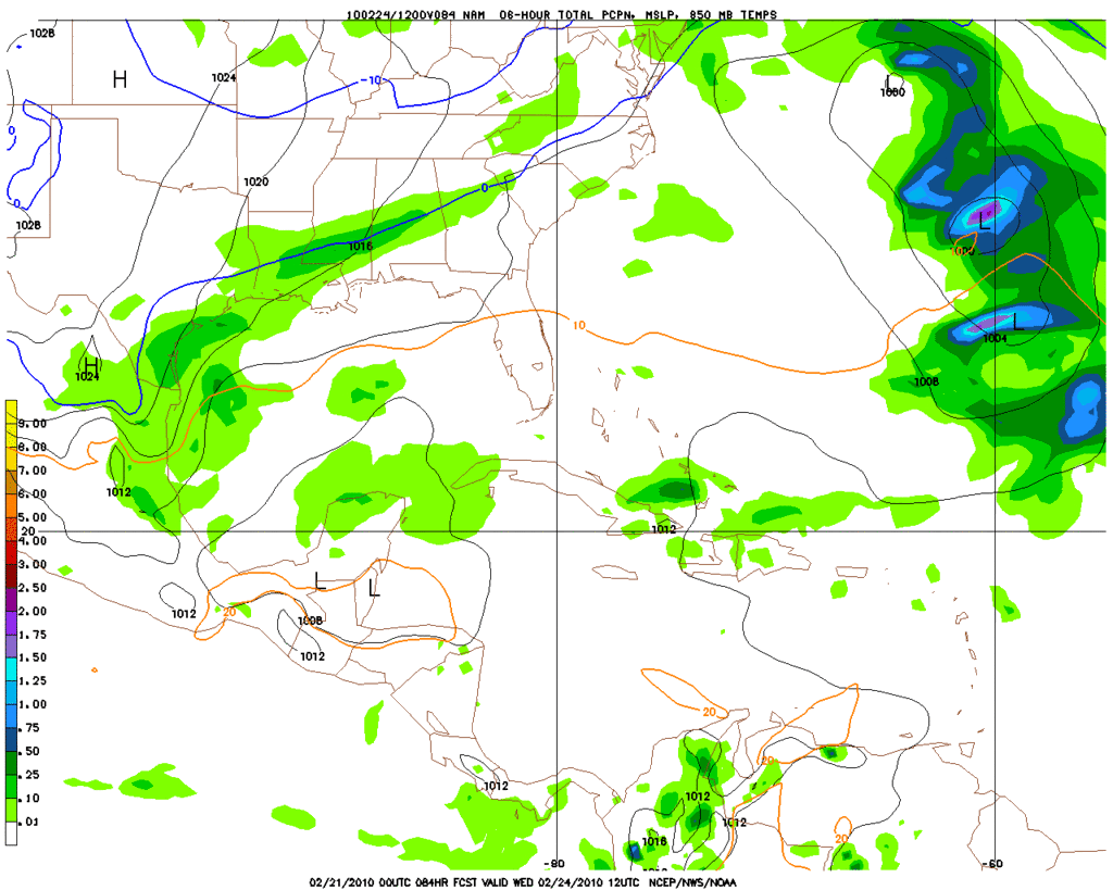
Hour 84 from a bit different view on the NAM...
Carla/Alicia/Jerry(In The Eye)/Michelle/Charley/Ivan/Dennis/Katrina/Rita/Wilma/Humberto/Ike/Harvey
Member: National Weather Association
Facebook.com/Weather Infinity
Twitter @WeatherInfinity
Member: National Weather Association
Facebook.com/Weather Infinity
Twitter @WeatherInfinity
-
rnmm
- Posts: 352
- Joined: Fri Feb 05, 2010 12:16 am
- Location: Santa Fe, Texas
- Contact:
I just looked at NOAA website and they are not calling for snow for my area (Santa Fe), so if anyone does get snow, will you throw a snowball for me? I know if the snow was close enough we could drive to see it, but I am too scared to drive in it and I am sure my husband's job won't let him off.............SIGH!!
My name is Nicole and I love weather!!
~~~~~~~~~~~~~~~~~~~~~~~~~~~~~~~~~~~~~~~~~~~~~~~~~~~~~~~~~~~~~~~~~~~~~~~~~~~~~~~~~~~~~~~~~~~~~~~~
Alicia, Allison, Rita, Ike
~~~~~~~~~~~~~~~~~~~~~~~~~~~~~~~~~~~~~~~~~~~~~~~~~~~~~~~~~~~~~~~~~~~~~~~~~~~~~~~~~~~~~~~~~~~~~~~~
Alicia, Allison, Rita, Ike
-
sleetstorm
- Posts: 651
- Joined: Thu Feb 04, 2010 12:33 pm
- Contact:
While none of us in this weather forum really knows what the day on Tuesday to Wednesday morning will bring weatherwise as far as how cold that southeast Texas will get and what type of precip. that we will receive, we are getting a better and better notion of what we could get during the day on Tuesday into Wednesday morning of this coming work week. I, for one, think that the high for this coming Tuesday is, in my opinion, ten to perhaps fifteen degrees too warm & it certainly could turn out that way if these two weather systems do happen to prove stronger than what some meteologists are showing or forecasting them to be.
-
Mr. T

- Posts: 992
- Joined: Wed Feb 03, 2010 4:22 pm
- Location: Kingwood
- Contact:
Everything is still looking good for some snow on tuesday here in Houston. The 0z CMC is even slightly colder and more moist than the GFS now!
-
Mr. T
- Posts: 992
- Joined: Wed Feb 03, 2010 4:22 pm
- Location: Kingwood
- Contact:
Temperatures were in the mid 30s and never reached freezing when the snow fell in December. Do you really think it will be warmer than that? I was thinking surface temperatures would be about the same...wxman57 wrote: One thing that bothers me about the snow potential here is that the airmass overhead on Tuesday morning may be a bit warmer than in December. For now, I expect to see a period of light snow mixed with rain and sleet as the precip ends Tuesday evening. Surface temps may be too warm for it to stick around.
-
don

- Posts: 3148
- Joined: Wed Feb 03, 2010 3:33 pm
- Location: Wichita Falls
- Contact:
-
Mr. T
- Posts: 992
- Joined: Wed Feb 03, 2010 4:22 pm
- Location: Kingwood
- Contact:
Both the Euro and CMC are slightly colder and definitely more moist than the GFS. The disturbance at hour 72 on the 0z Euro looks stronger than the more sheared look of the GFS, which obviously corealates to better lift over the area
I think we are beginning to arrive to the point where we know we'll likely see some snow tuesday evening. The question is obviously how much? We still have a while to figure that out...
-
srainhoutx
- Site Admin
- Posts: 19700
- Joined: Tue Feb 02, 2010 2:32 pm
- Location: Maggie Valley, NC
- Contact:
Overnight guidance continues to paint an interesting and very close scenario for us in SE TX. It appears timing of the coldest air as well as best lifting will be a factor as always in this part of the world. Areas from Del Rio to San Antonio, College Station, Brenham, Conroe and point N and E look like the best shot of seeing some mixing of rain, sleet and snow during the day on Tuesday as the mixing line moves slowly S in the afternoon on Tuesday into the evening hours before ending early Wednesday morning. There still remains a lot of uncertainty on how things will eventually play out, but the best chance for some accumulation look to be from Kerrville to just N of Austin to Lake Livingston and points N. The area just S of Dallas (near Waco/Centerville) would likely see all snow at this time. Things are still unfolding, so expect further refinement. Today will likely be the warmest day we have seen since late January so enjoy it will it lasts. All in all it's still a bit early and the event is still 2 days away, so things will continue to be refined as addintional guidance comes in. Stay Tuned as they say and I suspect there will be a lot of good information shared in the hours ahead.
Carla/Alicia/Jerry(In The Eye)/Michelle/Charley/Ivan/Dennis/Katrina/Rita/Wilma/Humberto/Ike/Harvey
Member: National Weather Association
Facebook.com/Weather Infinity
Twitter @WeatherInfinity
Member: National Weather Association
Facebook.com/Weather Infinity
Twitter @WeatherInfinity
-
Portastorm

- Posts: 800
- Joined: Wed Feb 03, 2010 3:04 pm
- Location: Southwest Austin/Oak Hill, TX
- Contact:
Well, FWIW this Sunday morning, the UKMET, the Japanese model (JMA), the Euro, and the Canadian all show the heaviest precip for this coming storm more into central and south central Texas. All are further south with the swath of highest QPF as compared to the GFS which hammers the San Angelo to Brownwood to Waco area.
Also notice that some of them don't appear to be as cold as yesterday so there could be more of a rain-snow mix in south central Texas. Let's see how the 12z runs shape up.
Also notice that some of them don't appear to be as cold as yesterday so there could be more of a rain-snow mix in south central Texas. Let's see how the 12z runs shape up.
-
wxman57

- Global Moderator

- Posts: 2621
- Joined: Thu Feb 04, 2010 5:34 am
- Location: Southwest Houston (Westbury)
- Contact:
Models are trending a little warmer for southeast Texas for Tuesday, as I had suspected they would last night. I looked at the 00Z and 06Z runs of the GFS and NAM and neither shows any significant snow in SE TX Tuesday. Remember that 24 hours ago, the GFS forecast a brief period that the air column overhead would be cold enough for snow as the precip was about to end here? Now it forecasts that column to be 3-5 degrees warmer overhead - too warm for snow to develop.
I was directed to a new (to me) web site that does an excellent job plotting projected snow accumulations (http://www.twisterdata.com/). I didn't realize that the snow map is actually clickable. For whatever time you're viewing, you can click on an area and generate a sounding. So I went to sounding mode and zoomed in on central Houston. Note the warm air aloft now. Then I went back to the map and captured a section of the snow accumulation map and pasted it to the sounding (see below).
I think we'll see some cold rain for the most part on Tuesday. Definitely no sleet to start out with like last time, as the air aloft will most certainly be too warm for sleet at the start. Could be some sleet toward the end of the precip (around 6pm-9pm Tuesday) and I wouldn't rule out any snowflakes. Just be happy with that, because nothing points to any accumulations here.
-
srainhoutx
- Site Admin
- Posts: 19700
- Joined: Tue Feb 02, 2010 2:32 pm
- Location: Maggie Valley, NC
- Contact:
The 12Z NAM is a touch colder...maybe folks N and W of DT Houston can squeeze out some big flakes mixed with some sleet before all is said and done. Another note is that temps are colder to the N in the Panhandle and the S Plains. We'll see what the 12Z GFS spits out. It is actually fairly amazing that we are even talking about any chances of wintry precip this late into February. 
http://www.nco.ncep.noaa.gov/pmb/nwprod ... _054.shtml
http://www.nco.ncep.noaa.gov/pmb/nwprod ... _060.shtml
http://www.nco.ncep.noaa.gov/pmb/nwprod ... _066.shtml
Also it is mighty chilly to our N...
http://www.nco.ncep.noaa.gov/pmb/nwprod ... _054.shtml
http://www.nco.ncep.noaa.gov/pmb/nwprod ... _060.shtml
http://www.nco.ncep.noaa.gov/pmb/nwprod ... _066.shtml
Also it is mighty chilly to our N...
Carla/Alicia/Jerry(In The Eye)/Michelle/Charley/Ivan/Dennis/Katrina/Rita/Wilma/Humberto/Ike/Harvey
Member: National Weather Association
Facebook.com/Weather Infinity
Twitter @WeatherInfinity
Member: National Weather Association
Facebook.com/Weather Infinity
Twitter @WeatherInfinity
-
wxman57
- Global Moderator
- Posts: 2621
- Joined: Thu Feb 04, 2010 5:34 am
- Location: Southwest Houston (Westbury)
- Contact:
One thing about those temps to our north. We have to consider that to get them south into Houston, they descend in altitude. When air descends it heats up. For example, look at the 27 in Amarillo this morning. To get that air to Houston, it would descend enough to warm up 20F, making it 47F in Houston. The conversion is about 13-15F for OKC. I used to have a map of all the conversions (back in the late 1970s at school).
What I'm seeing with this event is we'll be way too warm at the start. I've seen a lot of snow events on the Gulf Coast, and most start with dew points in the teens or low 20s. That allows the temp to drop below freezing during the precip so it can accumulate. I don't see that for this event.
What I'm seeing with this event is we'll be way too warm at the start. I've seen a lot of snow events on the Gulf Coast, and most start with dew points in the teens or low 20s. That allows the temp to drop below freezing during the precip so it can accumulate. I don't see that for this event.
-
don
- Posts: 3148
- Joined: Wed Feb 03, 2010 3:33 pm
- Location: Wichita Falls
- Contact:
The 12z GFS seems too have the cold air pushing in a bit faster before the main core of the pecip moves through the area...which is a good sign (seems more in line in what the CMC and European show)

Also shows snow accumulations of around an inch north of I-10! FWIW ofcourse

Also shows snow accumulations of around an inch north of I-10! FWIW ofcourse
Last edited by don on Sun Feb 21, 2010 10:10 am, edited 1 time in total.
-
sleetstorm
- Posts: 651
- Joined: Thu Feb 04, 2010 12:33 pm
- Contact:
I am going to laugh in a positive way if the temperature drops faster & becomes icier during the day on Tuesday than what is currently being depicted. Could we still get silver dollar size to grapefruit size snowflakes with this winter weather event, Mr. T, srainhoutx, and wxdata?
-
srainhoutx
- Site Admin
- Posts: 19700
- Joined: Tue Feb 02, 2010 2:32 pm
- Location: Maggie Valley, NC
- Contact:
Going to be mighty close sleet so hang in there. Grapefruit size? I highly doubt that.
Carla/Alicia/Jerry(In The Eye)/Michelle/Charley/Ivan/Dennis/Katrina/Rita/Wilma/Humberto/Ike/Harvey
Member: National Weather Association
Facebook.com/Weather Infinity
Twitter @WeatherInfinity
Member: National Weather Association
Facebook.com/Weather Infinity
Twitter @WeatherInfinity
-
sleetstorm
- Posts: 651
- Joined: Thu Feb 04, 2010 12:33 pm
- Contact:
That is good, right, don? I pray that model keeps moving in that direction too.don wrote:The 12z GFS seems too have the cold air pushing in a bit faster before the main core of the pecip moves through the area...which is a good sign (seems more in line in what the CMC and European show)
Also shows snow accumulations of around an inch north of I-10
-
don
- Posts: 3148
- Joined: Wed Feb 03, 2010 3:33 pm
- Location: Wichita Falls
- Contact:
Yep it is good if the 12z GFS verified there would be accumulating snow as far south as the northern half of Harris CountyThat is good, right, don? I pray that model keeps moving in that direction too.
heres the soundings for north Harris county
http://www.twisterdata.com/data/tmp/scr ... .5000W.png
http://www.twisterdata.com/data/tmp/scr ... .5000W.png
Last edited by don on Sun Feb 21, 2010 10:26 am, edited 1 time in total.
-
srainhoutx
- Site Admin
- Posts: 19700
- Joined: Tue Feb 02, 2010 2:32 pm
- Location: Maggie Valley, NC
- Contact:
Just a word of caution concerning what we have seen ALL winter season. The closer to the event the more it does seem that everything shifts a bit further S than progged at 48 hours. I'm pulling for you Portastorm and all of us that seen nothing so far this winter season.
Carla/Alicia/Jerry(In The Eye)/Michelle/Charley/Ivan/Dennis/Katrina/Rita/Wilma/Humberto/Ike/Harvey
Member: National Weather Association
Facebook.com/Weather Infinity
Twitter @WeatherInfinity
Member: National Weather Association
Facebook.com/Weather Infinity
Twitter @WeatherInfinity