Page 20 of 24
Re: 2011 ATL Hurricane Season: Watching The Cape Verde Waves
Posted: Fri Aug 12, 2011 7:15 am
by srainhoutx
Looks like an active weekend ahead...two new invests...94L: NE of the Leewards & 95L: E of the East Coast
TROPICAL WEATHER OUTLOOK
NWS NATIONAL HURRICANE CENTER MIAMI FL
800 AM EDT FRI AUG 12 2011
FOR THE NORTH ATLANTIC...CARIBBEAN SEA AND THE GULF OF MEXICO...
1. AN AREA OF LOW PRESSURE CENTERED ABOUT 1175 MILES EAST OF THE
NORTHERN LEEWARD ISLANDS IS MOVING WEST-NORTHWESTWARD AT NEAR 20
MPH. SHOWERS AND THUNDERSTORMS HAVE BECOME A LITTLE BETTER
ORGANIZED...AND ENVIRONMENTAL CONDITIONS ARE GRADUALLY BECOMING
MORE CONDUCIVE FOR DEVELOPMENT. THIS SYSTEM HAS A MEDIUM
CHANCE...40 PERCENT...OF BECOMING A TROPICAL CYCLONE DURING THE
NEXT 48 HOURS.
2. A BROAD LOW PRESSURE SYSTEM LOCATED ABOUT 450 MILES SOUTHWEST OF THE
SOUTHERN CAPE VERDE ISLANDS IS PRODUCING A LARGE AREA OF CLOUDINESS
AND SCATTERED SHOWERS. ENVIRONMENTAL CONDITIONS ARE EXPECTED
TO GRADUALLY BECOME MORE CONDUCIVE FOR DEVELOPMENT OVER THE NEXT
SEVERAL DAYS AS IT MOVES WESTWARD AT 15 TO 20 MPH. THIS SYSTEM HAS
A MEDIUM CHANCE...40 PERCENT...OF BECOMING A TROPICAL CYCLONE
DURING THE NEXT 48 HOURS.
3. SHOWER ACTIVITY ASSOCIATED WITH A WEAK LOW PRESSURE SYSTEM LOCATED
ABOUT 160 MILES WEST-NORTHWEST OF BERMUDA HAS CONTINUED TO BECOME A
LITTLE BETTER ORGANIZED. SOME ADDITIONAL DEVELOPMENT IS POSSIBLE
DURING THE NEXT DAY OR SO BEFORE THIS DISTURBANCE MERGES WITH A
FRONTAL SYSTEM. THIS SYSTEM HAS A MEDIUM CHANCE...30 PERCENT...OF
BECOMING A TROPICAL CYCLONE DURING THE NEXT 48 HOURS AS IT MOVES
NORTHEASTWARD AT 15 TO 20 MPH.
4. AN AREA OF DISTURBED WEATHER HAS FORMED IN ASSOCIATION WITH A BROAD
LOW PRESSURE AREA ABOUT 700 MILES NORTHEAST OF THE NORTHERN LEEWARD
ISLANDS. SLOW DEVELOPMENT IS POSSIBLE DURING THE NEXT COUPLE OF
DAYS AS THE LOW MOVES WEST-SOUTHWESTWARD AT ABOUT 10 MPH. THIS
SYSTEM HAS A LOW CHANCE...20 PERCENT...OF BECOMING A TROPICAL
CYCLONE DURING THE NEXT 48 HOURS.
ELSEWHERE...TROPICAL CYCLONE FORMATION IS NOT EXPECTED DURING THE
NEXT 48 HOURS.
$$
FORECASTER STEWART
The attachment 08122011 8 AM atl_overview.gif is no longer available
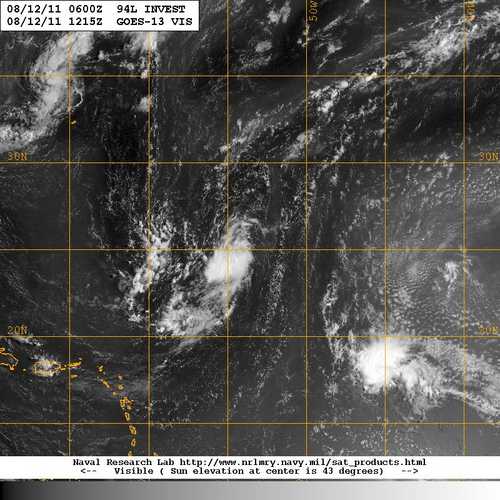
- 08122011_1215_goes13_x_vis2km_94LINVEST_25kts-1013mb-250N-536W_100pc.jpg (39.99 KiB) Viewed 6703 times
TCFP
Posted: Fri Aug 12, 2011 8:30 am
by unome
Re: 2011 ATL Hurricane Season: Watching The Cape Verde Waves
Posted: Fri Aug 12, 2011 9:35 am
by texoz
I don't recall ever seeing four invests lined up the way they are this morning. I'm sure it's happened in the recent past, but can't remember when. Should be a busy & interesting week ahead in the tropics.
Re: 2011 ATL Hurricane Season: Watching The Cape Verde Waves
Posted: Fri Aug 12, 2011 4:17 pm
by srainhoutx
The 12Z Euro Ensembles suggest a bit of a pattern change as we head toward the end of August. Ridging is looking more likely across the Western Atlantic and some weakness is showing up across Gulf Coastal regions. Oh, and a +NAO has a foothold as well. We will see...
Re: TCFP
Posted: Sun Aug 14, 2011 7:18 am
by unome
better tcfp in the gulf today
Re: 2011 ATL Hurricane Season: Watching The Cape Verde Waves
Posted: Sun Aug 14, 2011 11:09 am
by srainhoutx
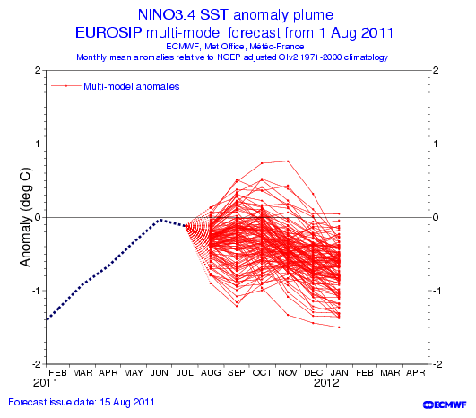
The new Eurosip seasonal forecast is out for September, October and November. The much lower pressures across the Atlantic, Caribbean and Gulf certainly do raise an eyebrow...
Re: 2011 ATL Hurricane Season: Watching The Cape Verde Waves
Posted: Mon Aug 15, 2011 7:20 am
by srainhoutx
TROPICAL WEATHER OUTLOOK
NWS NATIONAL HURRICANE CENTER MIAMI FL
800 AM EDT MON AUG 15 2011
FOR THE NORTH ATLANTIC...CARIBBEAN SEA AND THE GULF OF MEXICO...
THE NATIONAL HURRICANE CENTER IS ISSUING ADVISORIES ON TROPICAL
STORM GERT...LOCATED ABOUT 100 MILES SOUTHEAST OF BERMUDA.
1. A TROPICAL WAVE LOCATED ABOUT 325 MILES EAST OF THE LESSER ANTILLES
IS PRODUCING A LARGE AREA OF CLOUDINESS AND THUNDERSTORMS.
DEVELOPMENT OF THIS DISTURBANCE...IF ANY...SHOULD BE SLOW TO OCCUR
DURING THE NEXT COUPLE OF DAYS. HOWEVER...THIS DISTURBANCE WILL
PRODUCE BRIEF PERIODS OF LOCALLY HEAVY RAINFALL AND STRONG GUSTY
WINDS OVER PORTIONS OF THE CENTRAL AND NORTHERN LESSER ANTILLES
TODAY THROUGH TUESDAY. THIS SYSTEM HAS A LOW CHANCE...10 PERCENT...
OF BECOMING A TROPICAL CYCLONE DURING THE NEXT 48 HOURS AS IT MOVES
WESTWARD AT 15 TO 20 MPH.
2. SHOWER AND THUNDERSTORM ACTIVITY HAS CONTINUED TO DIMINISH IN
ASSOCIATION WITH A BROAD AREA OF LOW PRESSURE LOCATED ABOUT 650
MILES NORTH OF THE NORTHERN LEEWARD ISLANDS. ENVIRONMENTAL
CONDITIONS ARE BECOMING LESS CONDUCIVE FOR DEVELOPMENT OF
THIS SYSTEM OVER THE NEXT COUPLE OF DAYS DUE TO PROXIMITY TO
TROPICAL STORM GERT. THIS SYSTEM HAS A LOW CHANCE...NEAR 0
PERCENT...OF BECOMING A TROPICAL CYCLONE DURING THE NEXT 48 HOURS
AS IT MOVES TOWARD THE NORTH-NORTHWEST OR NORTH AT 15 TO 20 MPH.
ELSEWHERE...TROPICAL CYCLONE FORMATION IS NOT EXPECTED DURING THE
NEXT 48 HOURS.
$$
FORECASTER STEWART
Re: 2011 ATL Hurricane Season: Watching The Cape Verde Waves
Posted: Mon Aug 15, 2011 9:01 am
by srainhoutx
The 00Z Euro Ensembles continue to suggest lowering pressures across the Caribbean and Gulf as we head toward the end of August...
Re: 2011 ATL Hurricane Season: Watching The Cape Verde Waves
Posted: Mon Aug 15, 2011 10:53 am
by srainhoutx
Updated Roundy TC genesis probs for late August suggest and uptick in the Gulf. We will see...
Re: 2011 ATL Hurricane Season: Watching The Cape Verde Waves
Posted: Mon Aug 15, 2011 11:44 am
by srainhoutx
Another disturbance to watch is P17L currently just off the African Coast. The 12Z GFS suggests a W track across the Atlantic and strengthening as it enters the Caribbean.
SYNOPSIS 2011081500
P17L
13N, 16W
700 hPa
The vertical aligning of the 850-hPa from the northeast and the 700-hPa pouch from the east occurs within the first 24-48 hours of the forecast.
ECMWF: Large, easily-tracked pouch with only a little uncertainty in the analysis on the African coast. However, intensifies only slightly and temporarily as multiple small OW maxima never do coalesce upon the center.
GFS: Smooth track to the west, but with little to no intensification. Unlike ECMWF's singular pouch, GFS depicts a secondary, monsoonal pouch that forms in P17L's wake near the African coast. That secondary pouch gradually dissipates. Then at 84 hours, GFS temporarily elongates P17L NE-SW, with some uncertainty in the exact pouch position.
UKMET: (Not available)
NOGAPS: (Not examined)
HWRF-GEN: (Data only to 84 hours) Similar to GFS, with the development of a secondary pouch in P17L's wake to the east. Large pouch, but unchanging weak intensity throughout forecast.
ECMWF -7.1 v700 120h
GFS -7.1 v700 120h
UKMET ---- ---- ---h
NOGAPS ---- ---- ---h
HWGEN -7.5 v700 84h+
Re: 2011 ATL Hurricane Season: Watching The Cape Verde Waves
Posted: Mon Aug 15, 2011 12:58 pm
by wxman57
Long range GFS is interesting with respect to the wave near Africa:

Re: 2011 ATL Hurricane Season: Watching The Cape Verde Waves
Posted: Mon Aug 15, 2011 5:56 pm
by Ptarmigan
Interesting GFS model. That's weeks from now!
Not liking La Nina's return.
Climate Prediction Center 8/15/11 Update
Nino 3.4 is down from -0.4C of last week to -0.5C this week. Is now in the borderline between Neutral and La Nina.
Niño 4= -0.1ºC
Niño 3.4= -0.5ºC
Niño 3= -0.5ºC
Niño1+2= -0.1ºC

Many models suggest La Nina's return.

Re: 2011 ATL Hurricane Season: Watching The Cape Verde Waves
Posted: Mon Aug 15, 2011 6:35 pm
by tireman4
[quote="wxman57"]Long range GFS is interesting with respect to the wave near Africa:
[
Is this one given you pause? You worry, I get concerned...
Re: 2011 ATL Hurricane Season: Watching The Cape Verde Waves
Posted: Mon Aug 15, 2011 7:03 pm
by Rip76
That's a long way out to be concerned just yet, I would think.
Re: 2011 ATL Hurricane Season: Watching The Cape Verde Waves
Posted: Mon Aug 15, 2011 7:07 pm
by tireman4
Rip76 wrote:That's a long way out to be concerned just yet, I would think.
One of many in the long train coming. I am just saying....
Re: 2011 ATL Hurricane Season: Watching The Cape Verde Waves
Posted: Mon Aug 15, 2011 9:30 pm
by Ptarmigan
Joe Bastardi's take on the season.
A sample of his Tweets today:
Hurricane Frenzy may develop Aug 25-Sep 5. MJO shuts Sw pac, and leaves atlantic to carry load
Reminds of set up of burst in 2008 that lead to several landfalls in a row. coming right at the height of the season
4 of the 7 tropical storms so far are not of tropical origin but now the cap is about to come off and we will see the real deal come to life
GFS looks too far WEST given overall pattern with its hurricane into central gulf coast in 11-15 days. Model sways on every run
Euro in line with my ideas, more threat to fla in about 10 days, not gulf
Re: 2011 ATL Hurricane Season: Watching The Cape Verde Waves
Posted: Wed Aug 17, 2011 4:29 pm
by srainhoutx
I've had some inquiries as to some of the ensemble charts that may provide some different views of our pattern and what the future may hold. Here is one of those charts that
some might find helpful...
http://www.esrl.noaa.gov/psd/forecasts/gfsenkf/control/
http://www.weatheronline.co.uk/cgi-bin/ ... s&VAR=prec
Re: 2011 ATL Hurricane Season: Watching The Cape Verde Waves
Posted: Wed Aug 17, 2011 6:52 pm
by srainhoutx
TROPICAL WEATHER OUTLOOK
NWS NATIONAL HURRICANE CENTER MIAMI FL
800 PM EDT WED AUG 17 2011
FOR THE NORTH ATLANTIC...CARIBBEAN SEA AND THE GULF OF MEXICO...
1. AN AREA OF CLOUDINESS AND SHOWERS JUST TO THE SOUTH OF JAMAICA IS
ASSOCIATED WITH A TROPICAL WAVE. AN AIR FORCE HURRICANE HUNTER
AIRCRAFT INVESTIGATING THE AREA THIS AFTERNOON DID NOT FIND A
CLOSED CIRCULATION. HOWEVER...THE SYSTEM CONTINUES TO SHOW SIGNS
OF ORGANIZATION AND ENVIRONMENTAL CONDITIONS APPEAR CONDUCIVE FOR A
TROPICAL DEPRESSION TO FORM DURING THE NEXT DAY OR TWO. INTERESTS
ALONG THE COAST OF THE WESTERN CARIBBEAN SEA SHOULD MONITOR THE
PROGRESS OF THIS DISTURBANCE. THIS SYSTEM HAS A HIGH CHANCE...60
PERCENT...OF BECOMING A TROPICAL CYCLONE DURING THE NEXT 48 HOURS
AS IT MOVES GENERALLY WESTWARD AT 15 TO 20 MPH.
2. SHOWER ACTIVITY IS BEGINNING TO INCREASE IN ASSOCIATION WITH A
TROPICAL WAVE OVER THE EASTERN ATLANTIC ABOUT 750 MILES WEST OF THE
CAPE VERDE ISLANDS. ALTHOUGH SIGNIFICANT DEVELOPMENT IS NOT LIKELY
DURING THE NEXT COUPLE OF DAYS...CONDITIONS COULD BECOME MORE
CONDUCIVE FOR DEVELOPMENT THEREAFTER. THIS SYSTEM HAS A LOW
CHANCE...10 PERCENT...OF BECOMING A TROPICAL CYCLONE DURING THE
NEXT 48 HOURS AS IT MOVES WESTWARD NEAR 15 MPH.
ELSEWHERE...TROPICAL CYCLONE FORMATION IS NOT EXPECTED DURING THE
NEXT 48 HOURS.
$$
FORECASTER PASCH
Re: 2011 ATL Hurricane Season: Watching The Cape Verde Waves
Posted: Wed Aug 17, 2011 9:15 pm
by unome
Re: 2011 ATL Hurricane Season: Watching The Cape Verde Waves
Posted: Thu Aug 18, 2011 7:20 am
by srainhoutx
The GFS, Euro and GEM (Canadian) ensembles suggests a solution bringing the Atlantic disturbance
(P17L or some vortisity associated with it) near the Florida Keys and on into the Gulf in the medium/long range (6-10 day). While any development appears about 3-5 days away once it past 50-55W, the consensus among the operation and ensembles does raise an eyebrow and suggests this feature will need to be watched in the days ahead. And yet another wave appears to be leaving Africa as we enter an active pattern of African waves making thr trek W.

HPC morning prelim disco:
FINALLY THERE IS BETTER THAN
AVERAGE CLUSTERING FOR A DAY 7 FCST WITH THE POTENTIAL TROPICAL
SYSTEM FCST TO REACH CUBA OR THE BAHAMAS AT THAT TIME. THE
VARIOUS DETAIL ISSUES MENTIONED ABOVE LEAD TO FAVORING A BLEND OF
THE 00Z GEFS/12Z ECMWF ENSEMBLE MEANS THRU THE PERIOD. THIS SOLN
IS ADJUSTED SLIGHTLY TO ACCOMMODATE EXTRAPOLATION OF YDAYS
COORDINATED FCST WITH THE TROPICAL SYSTEM REACHING THE
BAHAMAS/CUBA... WITH MODEST ADJUSTMENT TO YIELD A TRACK A LITTLE
CLOSER TO THE MIDDLE OF THE CURRENT SPREAD.


