
July 2022
-
jasons2k

- Posts: 6201
- Joined: Thu Feb 04, 2010 12:54 pm
- Location: Imperial Oaks
- Contact:
Wow look at far West Texas.
- Attachments
-
-
Cpv17
- Posts: 7109
- Joined: Fri Aug 31, 2018 1:58 pm
- Location: El Campo/Wharton
- Contact:
-
Cpv17
- Posts: 7109
- Joined: Fri Aug 31, 2018 1:58 pm
- Location: El Campo/Wharton
- Contact:
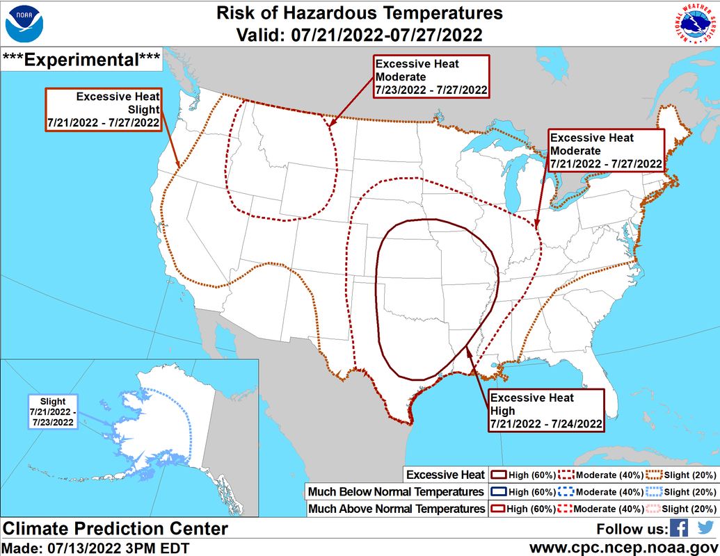
If this verifies we might be challenging some all time records in places..
-
Stratton20
- Posts: 5870
- Joined: Tue Feb 09, 2021 11:35 pm
- Location: College Station, Texas
- Contact:
Cpv17 its going to verify , I dont see how it doesnt lol
-
Cpv17
- Posts: 7109
- Joined: Fri Aug 31, 2018 1:58 pm
- Location: El Campo/Wharton
- Contact:
I’m honestly thinking a good part of the state will be seeing 105-115° unfortunately.Stratton20 wrote: ↑Wed Jul 13, 2022 6:04 pm Cpv17 its going to verify , I dont see how it doesnt lol
Well at least it wouldn’t surprise me with the way this summer has been.
-
Stratton20
- Posts: 5870
- Joined: Tue Feb 09, 2021 11:35 pm
- Location: College Station, Texas
- Contact:
Cpv17 we already broke a record high yesterday (111) wish a fast forward button existed for summer haha
-
Cpv17
- Posts: 7109
- Joined: Fri Aug 31, 2018 1:58 pm
- Location: El Campo/Wharton
- Contact:
Must be a really strange climate up there.. I mean I could understand BCS being 3-4 degrees warmer but it’s literally 5 to 10 degrees warmer there lately compared to the rest of southeast Texas.. that’s wack af.Stratton20 wrote: ↑Wed Jul 13, 2022 6:11 pm Cpv17 we already broke a record high yesterday (111) wish a fast forward button existed for summer haha
-
jasons2k
- Posts: 6201
- Joined: Thu Feb 04, 2010 12:54 pm
- Location: Imperial Oaks
- Contact:
My high yesterday was 105°F but I hit 110°F a few days ago.Cpv17 wrote: ↑Wed Jul 13, 2022 6:24 pmMust be a really strange climate up there.. I mean I could understand BCS being 3-4 degrees warmer but it’s literally 5 to 10 degrees warmer there lately compared to the rest of southeast Texas.. that’s wack af.Stratton20 wrote: ↑Wed Jul 13, 2022 6:11 pm Cpv17 we already broke a record high yesterday (111) wish a fast forward button existed for summer haha
-
Ptarmigan

- Statistical Specialist

- Posts: 4536
- Joined: Wed Feb 03, 2010 7:20 pm
- Contact:
-
jasons2k
- Posts: 6201
- Joined: Thu Feb 04, 2010 12:54 pm
- Location: Imperial Oaks
- Contact:
Today was mostly weak sauce across SE Texas.
Tomorrow was supposed to be the money day and now NWS chances are down to 30%. TWC app still shows 60% then nothing after tomorrow with temps back above 100 next week.
Tomorrow was supposed to be the money day and now NWS chances are down to 30%. TWC app still shows 60% then nothing after tomorrow with temps back above 100 next week.
-
Cpv17
- Posts: 7109
- Joined: Fri Aug 31, 2018 1:58 pm
- Location: El Campo/Wharton
- Contact:
I didn’t think we got this much but I just measured .45” in our gauge. Sweet!
-
captainbarbossa19

- Pro Met

- Posts: 460
- Joined: Mon Jun 28, 2021 2:50 pm
- Location: Conroe, TX
- Contact:
I'm starting to think that this will be another year where rainfall is below 40 inches and might be below 30 for the year. Normally by this time, I've had 35 inches. I'm not even to 15 yet. 2011 I had about 30 inches and 1917 had about 28. The good news was that 2012 was a lot wetter.
-
Cromagnum
- Posts: 3076
- Joined: Thu Feb 03, 2011 10:42 pm
- Location: Georgetown
- Contact:
Yeah, with the forecasted highs coming and nws dropping rain chances, I would say nothing of note is happening Thursday.
-
Cpv17
- Posts: 7109
- Joined: Fri Aug 31, 2018 1:58 pm
- Location: El Campo/Wharton
- Contact:
I beg to differ. I think we’ll see some widespread rains around here tomorrow. Looks pretty promising from what I can see. I think most of us will probably stay dry but a good amount of us will see something.
-
DoctorMu

- Posts: 8091
- Joined: Sun Jun 28, 2015 11:58 am
- Location: College Station
- Contact:
-
DoctorMu
- Posts: 8091
- Joined: Sun Jun 28, 2015 11:58 am
- Location: College Station
- Contact:
We've had 15 inches so far. Nothing since May.captainbarbossa19 wrote: ↑Wed Jul 13, 2022 9:10 pm I'm starting to think that this will be another year where rainfall is below 40 inches and might be below 30 for the year. Normally by this time, I've had 35 inches. I'm not even to 15 yet. 2011 I had about 30 inches and 1917 had about 28. The good news was that 2012 was a lot wetter.
-
jasons2k
- Posts: 6201
- Joined: Thu Feb 04, 2010 12:54 pm
- Location: Imperial Oaks
- Contact:
Rain chances at 40% today. That’s still less than 50/50. We’ll see….lots of radar and satellite watching today…
-
tireman4

- Global Moderator

- Posts: 7161
- Joined: Wed Feb 03, 2010 9:24 pm
- Location: Humble, Texas
- Contact:
000
FXUS64 KHGX 140928
AFDHGX
Area Forecast Discussion
National Weather Service Houston/Galveston TX
428 AM CDT Thu Jul 14 2022
.SHORT TERM [Tonight Through Tomorrow/Friday Night]...
The Heat Advisory will remain in place today for our NW counties as
very warm daytime temperatures and elevated heat indicies are expec-
ted...even with increased rain chances/clouds (via an overnight MCS
from the NE). Lingering effects of the mid/upper ridge (85h temps of
20-23C) along with increased low-level moisture/dewpoints will help
heat index values climb to near/just above criteria of 108F through
this afternoon. Highs for the NW counties to range from 100-104F...
mid to upper 90s for other inland areas.
Elsewhere, from the aforementioned MCS, its remnants along with any
lingering outflows, progged PWs up to 2" and low convective temperat-
ures should support scattered activity for much of today. Currently
not expecting any severe weather with development today, but models
are suggesting favorable conditions for strong gusty winds and some
locally heavy rains in and near the stronger storms.
We should get a little bit of a break later this evening but another
surge of very deep moisture (~2.2") from the Gulf will keep elevated
POPs in for generally the southern half of the CWA tomorrow/Fri. The
increase of POPs/clouds along with the retreating mid/upper ridge is
going help lower temps tomorrow...but mainly for locations south and
east of the I-10/US59 corridors where highs are forecast to range in
lower to mid 90s. Unfortunately, areas to the north and west of this
line could still highs around 100F. 41
&&
.LONG TERM [Saturday Through Thursday]...
Still expecting mid/upper level high pressure to gradually build/
strengthen back into our area over the weekend and especially on
into much of next week. There could be enough weakness in the
ridging to allow for mainly afternoon through early evening shower
and thunderstorm development, but will keep chances on the very
low side and mostly in/around our southeast areas. Lots of sun
unfortunately means more summer heat, and we`ll generally have
high temperatures ranging from the low to mid 90s near the coast
to the upper 90s to lower 100s inland. Once again, we will need to
monitor area heat index values for possible heat advisories.
42
&&
.MARINE...
Light to moderate onshore winds will persist through the remainder of
the week and into the weekend. Rain chances increase today and Friday
as disturbances move through the area. Winds and seas will be higher
in and near the storms. Increasing onshore winds and seas are anticipated
around the start of next week.
42
&&
.AVIATION [12Z TAF Issuance]...
Initial TAF issues will be dealing with the remnants of the MCS from
LA as it moves across the FA. As we head into the late morning/early
afternoon hours, lingering boundaries/outflows from the system along
with increased low-level moisture and daytime heating will support a
mention of VCTS for most sites this afternoon. A bit of a break late
this evening, but another surge of deeper moisture from the Gulf may
keep the mention of VCSH(for now) in for terminals from IAH south to
coast tonight/overnight as rain chances persist. 41
&&
.CLIMATE...
Yesterday, the City of Houston (IAH) recorded it`s 6th straight day
with a high temperature at or above 101 degrees. This ties for the
6th longest streak of 101+ degree highs in history and is the 2nd
longest streak in July (1st place is 12 days in July 1980).
Records date back to 5/1/1889.
Houston Hobby (HOU) had a high temperature yesterday of 99 degrees.
This ended their streak of four straight days with a high temperature
at or above 101 degrees, and this streak is the 2nd longest in Hobby`s
history (dating back to 8/1/1930). Their longest streak is seven days
in Aug/Sep of 2000. Before this year, Hobby had never had a July with
more than three consecutive days with a high temperature at or above
101 degrees (that was back in 1980).
Galveston tied another high minimum temperature record yesterday
when their low temperature only dropped to 84 degrees, and this made
it their 11th consecutive days that they have either tied or broken
their daily record high minimum temperature.
College Station`s high temperature yesterday was 106 degrees which
broke their old record of 105 degrees set in 1901. They have now
gone 12 consecutive days with a high temperature of 101 degrees or
more and 5 straight days with a high of 106 degrees or more. Their
previous July record with highs of 106 or more was three days back
in 1917. Their longest streak with highs of 106 or more is seven
days back in Aug/Sep 1980. Records date back to 10/01/1888.
42
&&
.PRELIMINARY POINT TEMPS/POPS...
College Station (CLL) 103 77 102 77 101 / 40 10 10 10 10
Houston (IAH) 99 76 97 77 98 / 30 20 30 20 20
Galveston (GLS) 93 81 95 82 96 / 30 40 30 20 20
&&
.HGX WATCHES/WARNINGS/ADVISORIES...
TX...Heat Advisory until 8 PM CDT this evening for the following
zones:
Austin...Brazos...Burleson...Colorado...Grimes...Houston...
Madison...Walker...Waller...Washington.
GM...None.
&&
$$
-
DoctorMu
- Posts: 8091
- Joined: Sun Jun 28, 2015 11:58 am
- Location: College Station
- Contact:
There's a line of showers moving SW from Tyler. Will they hold together?
A. Probably not.
A. Probably not.
-
Cromagnum
- Posts: 3076
- Joined: Thu Feb 03, 2011 10:42 pm
- Location: Georgetown
- Contact: