Page 19 of 79
Re: January 2024
Posted: Mon Jan 08, 2024 11:13 am
by Pas_Bon
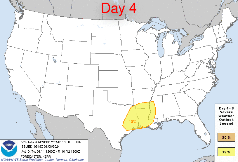
By the way, SPC has also included the HOU metro area (along with SETX/E TX/Most of Louisiana) in the "slight" risk for severe weather again on Friday.....
Re: January 2024
Posted: Mon Jan 08, 2024 11:18 am
by don
tireman4 wrote: ↑Mon Jan 08, 2024 11:07 am
don wrote: ↑Mon Jan 08, 2024 10:56 am
GFS getting close to showing an "Ana Front" winter storm setup fwiw.

Don, if you could, please show us how you are able to load images.

Of course, I use
https://imgbb.com to upload the pic. Then copy the image URL address, then click the insert image button when making a post, and paste the image URL in between the "[img]".
Re: January 2024
Posted: Mon Jan 08, 2024 11:38 am
by tireman4
don wrote: ↑Mon Jan 08, 2024 11:18 am
tireman4 wrote: ↑Mon Jan 08, 2024 11:07 am
don wrote: ↑Mon Jan 08, 2024 10:56 am
GFS getting close to showing an "Ana Front" winter storm setup fwiw.
Don, if you could, please show us how you are able to load images.
Of course, I use
https://imgbb.com to upload the pic. Then copy the image URL address, then click the insert image button when making a post, and paste the image URL in between the "[img]".
Thank you so much.
Re: January 2024
Posted: Mon Jan 08, 2024 11:41 am
by brazoriatx
Pardon my ignorance but what is a "ana front"?
Re: January 2024
Posted: Mon Jan 08, 2024 11:41 am
by tireman4
ERCOT is closely monitoring the weather conditions moving across Texas this week. Grid conditions are expected to be normal, and ERCOT expects to have sufficient supply to meet demand. Any outages are local in nature. Please contact your local electric provider for information if you are experiencing an outage:
http://bit.ly/3TQXHSA. You can monitor grid conditions on
http://ercot.com and the app.
@PUCTX
@TDEM
Re: January 2024
Posted: Mon Jan 08, 2024 11:48 am
by tireman4
An ana front is a frontal boundary in which the main shield of clouds and precipitation is located behind the actual frontal boundary.
This is because cold air located behind the front moves rapidly, pushing against the warm air out ahead of the front. Because cold air is more dense than warm air, the surging cold air causes the warm air to lift upward along the front. Therefore, clouds and precipitation that form end up inclined rearward with height due to the advancing cold air at the surface.
Re: January 2024
Posted: Mon Jan 08, 2024 11:52 am
by jasons2k
Areas around Navasota and then NE of there have been pounded today.
Re: January 2024
Posted: Mon Jan 08, 2024 12:03 pm
by djmike
We have a local met who is now saying the dynamics of todays threat are now more towards Louisiana than Setx now. If that is true, nothing really happened. Is this true?
Re: January 2024
Posted: Mon Jan 08, 2024 12:11 pm
by djmike
Also, why has no one issued a tornado watch for today with the threat of tornados?
Re: January 2024
Posted: Mon Jan 08, 2024 12:12 pm
by jasons2k
djmike wrote: ↑Mon Jan 08, 2024 12:11 pm
Also, why has no one issued a tornado watch for today with the threat of tornados?
Later today
Re: January 2024
Posted: Mon Jan 08, 2024 12:15 pm
by Cromagnum
Everything so far today is opening act stuff. I would expect things to start cranking this afternoon if anything is gonna get going ahead of the squall line.
Re: January 2024
Posted: Mon Jan 08, 2024 12:34 pm
by jasons2k
My dew point was 46 this morning, now it’s 68…
Re: January 2024
Posted: Mon Jan 08, 2024 12:38 pm
by Pas_Bon
Cromagnum wrote: ↑Mon Jan 08, 2024 12:15 pm
Everything so far today is opening act stuff. I would expect things to start cranking this afternoon if anything is gonna get going ahead of the squall line.
I’m by no means a professional meteorologist, but this afternoon/evening has me concerned.
Re: January 2024
Posted: Mon Jan 08, 2024 12:40 pm
by Pas_Bon
tireman4 wrote: ↑Mon Jan 08, 2024 11:41 am
ERCOT is closely monitoring the weather conditions moving across Texas this week. Grid conditions are expected to be normal, and ERCOT expects to have sufficient supply to meet demand. Any outages are local in nature. Please contact your local electric provider for information if you are experiencing an outage:
http://bit.ly/3TQXHSA. You can monitor grid conditions on
http://ercot.com and the app.
@PUCTX
@TDEM
I’ll believe it when I see it.

This is what happens when your abysmal handling of the icemageddon 3yrs ago remains front and center
Re: January 2024
Posted: Mon Jan 08, 2024 12:42 pm
by Cpv17
Pas_Bon wrote: ↑Mon Jan 08, 2024 11:13 am
By the way, SPC has also included the HOU metro area (along with SETX/E TX/Most of Louisiana) in the "slight" risk for severe weather again on Friday.....
This is why I never really worry about severe thunderstorms where I live. It’s almost always north of me, especially NE of me.
Re: January 2024
Posted: Mon Jan 08, 2024 12:50 pm
by MontgomeryCoWx
Pas_Bon wrote: ↑Mon Jan 08, 2024 12:40 pm
tireman4 wrote: ↑Mon Jan 08, 2024 11:41 am
ERCOT is closely monitoring the weather conditions moving across Texas this week. Grid conditions are expected to be normal, and ERCOT expects to have sufficient supply to meet demand. Any outages are local in nature. Please contact your local electric provider for information if you are experiencing an outage:
http://bit.ly/3TQXHSA. You can monitor grid conditions on
http://ercot.com and the app.
@PUCTX
@TDEM
I’ll believe it when I see it.
This is what happens when your abysmal handling of the icemageddon 3yrs ago remains front and center
I’ve stated it on here many times, but the average individual who wants to be told by social media what to think doesn’t understand what the true cause was in 2021 because social media buries the simple answer.
I’m not worried about the grid, not one iota, because I know why it happened and what has happened since then regarding the offline Nat Gas substations in 2021.
If you want cheap electricity and a fortified grid, don’t vote for people pushing the Green Feudalism BS on a local, state or federal level.
The average human in first world countries really doesn’t understand scale anymore, especially utility scale. I have more off grid, environmentally friendly contraptions at the farm that help us survive no matter what. It’s great. I’m a survivalist and use your earthly resources guy at heart. With that said, You can’t take that idea and scale it to a municipality or large city without severe arbitrage. I won’t even get into supply chains and National Security around the grid.
If the grid explanation sounds too simple from either political divide, then it’s most likely there to divide and not educate.
Re: January 2024
Posted: Mon Jan 08, 2024 1:05 pm
by Stratton20
Big winter storm on the Euro, bringing snow/ ice down into the houston metro
Re: January 2024
Posted: Mon Jan 08, 2024 1:10 pm
by MontgomeryCoWx
Stratton20 wrote: ↑Mon Jan 08, 2024 1:05 pm
Big winter storm on the Euro, bringing snow/ ice down into the houston metro
Post it. On my phone right now trying to winterize our AWG and cattle troughs.
Re: January 2024
Posted: Mon Jan 08, 2024 1:19 pm
by Harp1
Stratton20 wrote: ↑Mon Jan 08, 2024 1:05 pm
Big winter storm on the Euro, bringing snow/ ice down into the houston metro
Thanks for the update. Watching all of this over here in Louisiana. What Houston gets, many times we get the next day.
Re: January 2024
Posted: Mon Jan 08, 2024 1:22 pm
by jasons2k
Getting closer….
Special Weather Statement
National Weather Service Fort Worth TX
1248 PM CST Mon Jan 8 2024
Robertson TX-Falls TX-Limestone TX-Anderson TX-Leon TX-Freestone TX-
...Strong thunderstorms will impact portions of Freestone, Robertson, northeastern Milam, western Leon, southeastern Henderson, central Limestone, southeastern Falls, northwestern Anderson and southeastern Navarro Counties through 145 PM CST...
At 1248 PM CST, Doppler radar was tracking strong thunderstorms along a line extending from near Richland-Chambers Reservoir to 6 miles southeast of Cameron. Movement was east at 35 mph.
HAZARD...Winds in excess of 30 mph.
SOURCE...Radar indicated.
IMPACT...Gusty winds could knock down tree limbs and blow around unsecured objects.
Strong thunderstorms will be near... Teague, Fairfield, Calvert, Bremond, Richland-Chambers Reservoir, and Lake Limestone around 1255 PM CST. Twin Oak Reservoir around 100 PM CST. Hearne and Fairfield Lake around 105 PM CST. Franklin and Fairfield Lake State Park around 110 PM CST. Coon Creek Lake around 115 PM CST. Buffalo and Camp Creek Lake around 130 PM CST.
Other locations impacted by these storms include Bradford, Hoyte, Streetman, Donie, New Baden, Cayuga, Cross Roads, Oletha, Bethel, and Kirvin.
This includes Interstate 45 between mile markers 173 and 217.
PRECAUTIONARY/PREPAREDNESS ACTIONS...
If outdoors, consider seeking shelter inside a building.
&&
TIME...MOT...LOC 1848Z 256DEG 32KT 3200 9620 3078 9691
MAX HAIL SIZE...0.00 IN
MAX WIND GUST...30 MPH
$$
Hernandez