Page 17 of 70
Re: TD 1 Forms. 255 Miles ESE of Belize City
Posted: Sat Jun 26, 2010 12:19 am
by Paul
Re: TD 1 Forms. 255 Miles ESE of Belize City
Posted: Sat Jun 26, 2010 12:40 am
by Scott747
0z HWRF is a bit N, near Brownsville.
0z GFDL is left and near the mid Texas coast.
T
Re: TD 1 Forms. 255 Miles ESE of Belize City
Posted: Sat Jun 26, 2010 12:46 am
by Mr. T
Scott747 wrote:0z HWRF is a bit N, near Brownsville.
a lot slower, too
0z GFDL is left and near the mid Texas coast.
Between Houston and Corpus, lol
Re: TD 1 Forms. 255 Miles ESE of Belize City
Posted: Sat Jun 26, 2010 12:50 am
by Paul
Mr. T wrote:Scott747 wrote:0z HWRF is a bit N, near Brownsville.
a lot slower, too
0z GFDL is left and near the mid Texas coast.
Between Houston and Corpus, lol
actually the GFDL is right into Freeport / surfside as a stout CAT 2 storm....put the west side of Brazoria County in the right front quad.....
highly doubt it will verify...I think it is taking small steps to catch up to the rest of the models...
EDIT to add that it makes it up to 96knots right before landfall....that is IKE intensity...high end Cat 2 at 110.4 MPH
Re: TD 1 Forms. 255 Miles ESE of Belize City
Posted: Sat Jun 26, 2010 12:55 am
by Andrew
Paul wrote:Mr. T wrote:Scott747 wrote:0z HWRF is a bit N, near Brownsville.
a lot slower, too
0z GFDL is left and near the mid Texas coast.
Between Houston and Corpus, lol
actually the GFDL is right into Freeport / surfside as a stout CAT 2 storm....put the west side of Brazoria County in the right front quad.....
highly doubt it will verify...I think it is taking small steps to catch up to the rest of the models...

I think it is possible I mean I believe the trough will impact the storm and if the storms really intensifies more than originally thought then it could take that northern route. My person belief is that Alex is actually going to go into Corpus.
Re: TD 1 Forms. 255 Miles ESE of Belize City
Posted: Sat Jun 26, 2010 12:55 am
by tgal
This year there is less excitement as the storms begin to swirl because all I can think about is the oil covered Gulf and its people being hit while they are down.
I would appreciate it if some of the pros would add comments about how you believe the oil issue will play into the storm paths.
I look forward to another interesting year and thanks to all of you in advance. I know how helpful you will be this season
Re: TD 1 Forms. 255 Miles ESE of Belize City
Posted: Sat Jun 26, 2010 12:58 am
by Paul
I dont know how much that trof is going to dig...but I do know behind it will be a high building in...going to be interesting....EURO comes out in 45 minutes.....wanna make a bet it stick to its guns?

Re: TD 1 Forms. 255 Miles ESE of Belize City
Posted: Sat Jun 26, 2010 1:00 am
by Ptarmigan
Paul wrote:
actually the GFDL is right into Freeport / surfside as a stout CAT 2 storm....put the west side of Brazoria County in the right front quad.....
highly doubt it will verify...I think it is taking small steps to catch up to the rest of the models...
EDIT to add that it makes it up to 96knots right before landfall....that is IKE intensity...high end Cat 2 at 110.4 MPH
If Alex was a Category 2 hurricane hitting our area in June that would be on the record books as rather unusual. On the flip side, it is not as large as Ike.


I doubt Alex would be a Category 2, but can't rule that out either.
Re: TD 1 Forms. 255 Miles ESE of Belize City
Posted: Sat Jun 26, 2010 1:02 am
by Scott747
Paul wrote:Mr. T wrote:Scott747 wrote:0z HWRF is a bit N, near Brownsville.
a lot slower, too
0z GFDL is left and near the mid Texas coast.
Between Houston and Corpus, lol
actually the GFDL is right into Freeport / surfside as a stout CAT 2 storm....put the west side of Brazoria County in the right front quad.....
highly doubt it will verify...I think it is taking small steps to catch up to the rest of the models...
EDIT to add that it makes it up to 96knots right before landfall....that is IKE intensity...high end Cat 2 at 110.4 MPH
Actually it's more towards Sargent and 90 knots offshore.
Re: TD 1 Forms. 255 Miles ESE of Belize City
Posted: Sat Jun 26, 2010 1:11 am
by Paul
surfside / sargent...close enough..and its 96.5 knots off shore then drops to 87.8 knots right before landfall...
http://moe.met.fsu.edu/cgi-bin/gfdltc2. ... =Animation
http://moe.met.fsu.edu/cgi-bin/gfdltc2. ... =Animation
lets not split hairs....
Re: TD 1 Forms. 255 Miles ESE of Belize City
Posted: Sat Jun 26, 2010 1:17 am
by Paul
Ed Mahmoud wrote:Lets keep an eye on the dModel/dt, as I've seen it described in AFDs. The new GFDL is 'trending' leftward from the old one. Is that a trend, or not? The 6Z and 12Z GFDL may tell the tale. But if it is a trend, and the GFDL isn't oscillating around a SW Louisiana/Upper Texas Coast landfall, which I suspect it isn't, next run may be down towards BRO or CRP.
I think its playing catch up myself....it had to at some point the odds were against it after the HWRF did a total 180....the GFDL is just doing it increments.....

Re: TD 1 Forms. 255 Miles ESE of Belize City
Posted: Sat Jun 26, 2010 1:18 am
by Paul
Ed Mahmoud wrote:
The 87.8 knots is at 35 meters, and as the statement advises, 10 meter winds will usually be less.
your splitting hairs ED....

Re: TD 1 Forms. 255 Miles ESE of Belize City
Posted: Sat Jun 26, 2010 1:18 am
by Scott747
Paul wrote:surfside / sargent...close enough..and its 96.5 knots off shore then drops to 87.8 knots right before landfall...
lets not split hairs....
I'm not 'splitting hairs.'
Just giving a more accurate representation of what the model was showing.
No worries.
Re: TD 1 Forms. 255 Miles ESE of Belize City
Posted: Sat Jun 26, 2010 1:25 am
by Mr. T
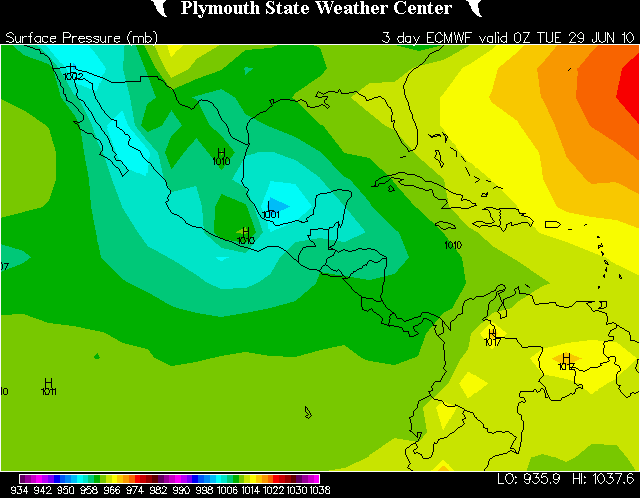
0z Euro is waaaaay south again
Re: TD 1 Forms. 255 Miles ESE of Belize City
Posted: Sat Jun 26, 2010 1:27 am
by Paul
Mr. T wrote:0z Euro is waaaaay south again
post it...my sites have not updated..got another 15minutes for me..
Re: TD 1 Forms. 255 Miles ESE of Belize City
Posted: Sat Jun 26, 2010 1:29 am
by Scott747
Mr. T wrote:0z Euro is waaaaay south again
Still can't see it going that far S.
Re: TD 1 Forms. 255 Miles ESE of Belize City
Posted: Sat Jun 26, 2010 1:29 am
by Mr. T
Paul wrote:Mr. T wrote:0z Euro is waaaaay south again
post it...my sites have not updated..got another 15minutes for me..

Re: TD 1 Forms. 255 Miles ESE of Belize City
Posted: Sat Jun 26, 2010 1:31 am
by Scott747
Although it's currently moving westward even though it's supposed to resume the wnw heading.
Re: TD 1 Forms. 255 Miles ESE of Belize City
Posted: Sat Jun 26, 2010 1:33 am
by Mr. T
Scott747 wrote:
Still can't see it going that far S.
Yeah. It would be a rather strange track... You have to admit, though, that it has been on the ball regarding the more southerly route, while other tropical models have had a northerly bias thus far. Just looking at the latest satellite presentation would suggest that TD 1 really isn't gaining much latitude at the moment. The Euro keeps a general WNW motion through the period.
Re: TD 1 Forms. 255 Miles ESE of Belize City
Posted: Sat Jun 26, 2010 1:35 am
by Paul
you would think that now it is a TS it would gain some lat....that is like way way south....that super trof is not as bad as the GFS is progging....

