
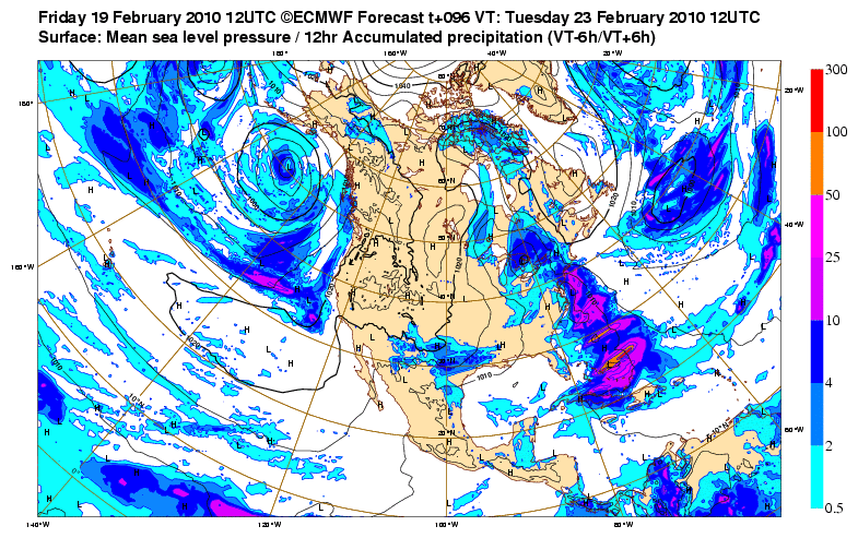
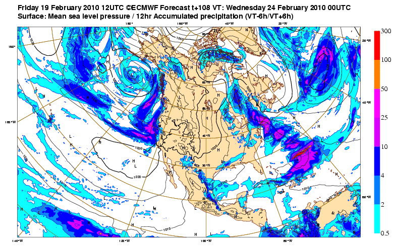
Ah, the regular ECMWF site. But I do notice they're precipitation amounts, not snowfall accumulation. I thought they were snow maps at first.srainhoutx wrote:Saved the link for you wxman57...wxman57 wrote:What's the link to that free ECMWF site, srain? Is that on the Penn State eWall or the actual ecmwf page?srainhoutx wrote:Also will add the the Free Site for the ECMWF offered a little bonus freebie today. Precip Maps...
Hour 96...
http://i228.photobucket.com/albums/ee29 ... h32Ame.gif
Hour 108...
http://i228.photobucket.com/albums/ee29 ... th32Am.gif
http://www.ecmwf.int/samples/d/inspect/ ... 2010021912!!/
February Weather Discussion. Wild Winter Storms?
-
wxman57

- Global Moderator

- Posts: 2621
- Joined: Thu Feb 04, 2010 5:34 am
- Location: Southwest Houston (Westbury)
- Contact:
-
srainhoutx

- Site Admin

- Posts: 19700
- Joined: Tue Feb 02, 2010 2:32 pm
- Location: Maggie Valley, NC
- Contact:
They offer a bonus from time to time on the ECMWF site. I'll keep an eye out in the days ahead. Longer Range shows a big Spring Storm.
Carla/Alicia/Jerry(In The Eye)/Michelle/Charley/Ivan/Dennis/Katrina/Rita/Wilma/Humberto/Ike/Harvey
Member: National Weather Association
Facebook.com/Weather Infinity
Twitter @WeatherInfinity
Member: National Weather Association
Facebook.com/Weather Infinity
Twitter @WeatherInfinity
-
don

- Posts: 3148
- Joined: Wed Feb 03, 2010 3:33 pm
- Location: Wichita Falls
- Contact:
Dont look at the 18z cause it aint pretty if you want snow around here...(o fcourse its early and its only one model run and the 18z lol)
-
Paul

- Posts: 535
- Joined: Wed Feb 03, 2010 11:46 pm
- Location: Pearland
- Contact:
is it TS season yet? ugh...this event does not excite me as much as the Dec 4th. Too many uncertainies with this one...will join the night crew for the 0z GFS though...
-
TexasMetBlake
- Pro Met

- Posts: 839
- Joined: Wed Feb 03, 2010 7:03 pm
- Location: Spring/Woodlands
- Contact:
It's a bit slower with the cold air, but no big deal. Still a ways away. Like wxman said one time, how can you pick one model over the other? There is so much variability still that one run is just as good as another. I wait with bated breath for the 0z euro and gfs.
-
don
- Posts: 3148
- Joined: Wed Feb 03, 2010 3:33 pm
- Location: Wichita Falls
- Contact:
I agree for some reason im a little less optimistic about this one,still optimistic just a little less than i was during the December event...But im still holding out hope for some accumulating snowPaul wrote:is it TS season yet? ugh...this event does not excite me as much as the Dec 4th. Too many uncertainies with this one...will join the night crew for the 0z GFS though...
-
srainhoutx
- Site Admin
- Posts: 19700
- Joined: Tue Feb 02, 2010 2:32 pm
- Location: Maggie Valley, NC
- Contact:
FYI: HPC Updated the Final Extended again for what it is worth...
EXTENDED FORECAST DISCUSSION
NWS HYDROMETEOROLOGICAL PREDICTION CENTER CAMP SPRINGS MD
251 PM EST FRI FEB 19 2010
VALID 12Z MON FEB 22 2010 - 12Z FRI FEB 26 2010
12Z DETERMINISTIC MODELS HAVE STRONGLY CONVERGED ON THEIR PATTERN
E OF THE ROCKIES DAYS 4-7 CONCERNING THE DEVELOPMENT OF ANOTHER
POSSIBLE MAJOR SNOWSTORM WED NIGHT/THU FOR THE MID ATLANTIC AND
ESPECIALLY NEW ENG. HELPING TO ACHIEVE THIS MUCH BETTER AGREEMENT
WERE MODELS FINALLY COMING INTO AGREEMENT SUN/MON...DAYS 2-3...IN
TURNING A PACIFIC SHORTWAVE N AROUND THE W SIDE OF A BLOCKING HIGH
INSTEAD OF TRYING TO UNDERCUT THE BLOCK AS SOME WERE DOING IN
YESTERDAYS RUNS.
00Z/19 ENSEMBLE SPAGHETTI PLOTS HAD SHOWN THE DETERMINISTIC 00Z/19
ECMWF/CANADIAN SOLUTIONS...WITH SIGNIFICANT UPPER ENERGY OVER THE
SWRN CONUS THU DAY 6....AS OPPOSED TO THE GFS/UKMET FAMILY OF
SOLUTIONS. THE 00Z/19 GFS/UKMET FAMILY OF S SOLUTIONS (TOWARD
WHICH 12Z/19 MODELS HAVE CONVERGED) HAD THE MAIN SRN STREAM SYS
CROSSING THE GULF COAST STATES WED NIGHT. THIS WAS MORE IN LINE
WITH YESTERDAYS ECMWF RUNS. THE 00Z/19 GFS/UKMET ALSO SHOWED
ENERGY DROPPING S OUT OF A NRN CANADIAN VORTEX BY THU.
ONE SRN STREAM SHORTWAVE MOVES RAPIDLY ENE TO THE E COAST DAYS 3-4
AND SHOULD BRING A MODERATE SNOW EVENT TO THE UPPER OH VLY ACROSS
NE PA TO SRN NEW ENG. FARTHER S...MOSTLY A RA EVENT IS EXPECTED.
HOWEVER...SLOW DEPARTURE OF A NEWFOUNDLAND LOW EARLY MON COULD
DELAY A CHANGEOVER TO RAIN WITH THIS SYS ALONG THE MASON DIXON
LINE AND POINTS S. FOR NOW THOUGH..WE ARE CONTINUING THE TREND FOR
MOSTLY RA WITH THIS SYS MON BELOW THE MD/PA BORDER. FOR
TUE...EXPECT SIGNIFICANT SNOW ACROSS SRN NEW ENG.
A BETTER THREAT FOR A MAJOR SNOWSTORM COMES FROM THE NEXT SRN
STREAM WAVE WHICH TRACKS ACROSS THE SRN STATES TUE INTO EARLY
THU...AT THE SAME TIME THAT A POTENT PIECE OF ENERGY DROPS SWD
FROM THE POLAR VORTEX IN FAR NRN CANADA. THE AMPLITUDE OF THIS
NEXT SRN STREAM SYS IS LIKELY UNDERDONE BY NEW 12Z/19 MODELS. THE
STRONG SRN STREAM SYS COULD ALSO HELP LAY DOWN A STRIPE OF HEAVY
SNOW ACROSS THE DEEP S FROM TX ACROSS THE GULF STATES ON ITS EWD
TREK TO THE SE COAST. WITH MODELS CONVERGING ON THE NERN STREAM
CLOSING OFF OVER THE UPPER OH VLY AND MID ATLANTIC BY THU DAY
6...THE STAGE IS SET FOR ANOTHER MAJOR SNOW STORM FOR THE MID
ATLANTIC/NEW ENG.
W OF THE ROCKIES...THE W COAST BECOME RATHER UNCERTAIN AS THE MEAN
RIDGE NEAR THE W COAST OF NOAM WEAKENS. FAIRLY STRONG WESTERLIES
WILL IMPINGE ALONG THE W COAST FROM CA NWD FROM DAY 5 ONWARD
GIVING HEAVY OROGRAPHIC PCPN. TIMING OF THESE W COAST SHORTWAVES
BEYOND DAY 5 IS BELOW AVERAGE CONFIDENCE.
FLOOD
Carla/Alicia/Jerry(In The Eye)/Michelle/Charley/Ivan/Dennis/Katrina/Rita/Wilma/Humberto/Ike/Harvey
Member: National Weather Association
Facebook.com/Weather Infinity
Twitter @WeatherInfinity
Member: National Weather Association
Facebook.com/Weather Infinity
Twitter @WeatherInfinity
-
srainhoutx
- Site Admin
- Posts: 19700
- Joined: Tue Feb 02, 2010 2:32 pm
- Location: Maggie Valley, NC
- Contact:
00Z's have started. I suspect the "night crew" will be active with severe and wintry in a couple of days...it IS "Trail Ride Season" you know... 
Hour 24
http://www.nco.ncep.noaa.gov/pmb/nwprod ... _024.shtml
Hour 42
http://www.nco.ncep.noaa.gov/pmb/nwprod ... _042.shtml
Hour 24
http://www.nco.ncep.noaa.gov/pmb/nwprod ... _024.shtml
Hour 42
http://www.nco.ncep.noaa.gov/pmb/nwprod ... _042.shtml
Carla/Alicia/Jerry(In The Eye)/Michelle/Charley/Ivan/Dennis/Katrina/Rita/Wilma/Humberto/Ike/Harvey
Member: National Weather Association
Facebook.com/Weather Infinity
Twitter @WeatherInfinity
Member: National Weather Association
Facebook.com/Weather Infinity
Twitter @WeatherInfinity
-
TexasMetBlake
- Pro Met
- Posts: 839
- Joined: Wed Feb 03, 2010 7:03 pm
- Location: Spring/Woodlands
- Contact:
Hour 90:

-
TexasMetBlake
- Pro Met
- Posts: 839
- Joined: Wed Feb 03, 2010 7:03 pm
- Location: Spring/Woodlands
- Contact:
96 hours:

-
TexasMetBlake
- Pro Met
- Posts: 839
- Joined: Wed Feb 03, 2010 7:03 pm
- Location: Spring/Woodlands
- Contact:
102 hours: looks a bit colder than 18z just by glancing at it.

-
TexasMetBlake
- Pro Met
- Posts: 839
- Joined: Wed Feb 03, 2010 7:03 pm
- Location: Spring/Woodlands
- Contact:
hour 108:

-
weatherguy425
- Pro Met
- Posts: 830
- Joined: Wed Feb 03, 2010 7:45 pm
- Location: Atlanta, Georgia
- Contact:
Hmmm... DFW forecasting all snow for basically thier entire CWA
-
weatherguy425
- Pro Met
- Posts: 830
- Joined: Wed Feb 03, 2010 7:45 pm
- Location: Atlanta, Georgia
- Contact:
EWX has also added a rain/snow mix for northern half of their CWA
-
Rich
- Posts: 79
- Joined: Fri Feb 19, 2010 9:38 pm
- Location: Pearland,Tx
- Contact:
Candy Cane, After looking at tonight's 00Z runs do you think chance for wintry precipitation here in the houston area is looking more likely?
-
Kludge

- Posts: 280
- Joined: Wed Feb 03, 2010 11:53 pm
- Location: Montgomery (Walden) TX
- Contact:
If a Weather Expert logs onto a Weather Forum, visited almost exclusively by those hoping to see exceptional weather, and consistently advises that there will be no exceptional weather, shouldn't that Expert anticipate that the Forum will soon cease to be visited?wxman57 wrote:Just checked 12Z GFS sounding forecasts for IAH. The model suggests cold rain changing to a mixture of rain and sleet as the precip ends Tuesday night. With that pattern, I couldn't rule out a few snowflakes but I don't see a snow "event" for Houston given the latest data.
And when the Expert's "advice" does... or does not... become reality, will anyone still be there to advise? Before long, the Expert will soon have no place onto which he can throw a wet blanket.
If i were a commercial adveriser on the forum I would probably pay Portastorm to make hourly posts....
Point is: we can all find reasons for why it won't snow in Houston everywhere we look. Most of us come to this board to find reasons why it may snow. I submit that "Expert" interjection is only welcomed when the signs are good...else this forum will be moot.
Moral: Experts..... play along. We know snow's unlikely here. Duh. Humor us. Don't piss on our cornflakes. Chime-in when happiness might become reality. Otherwise... lurk. We know your're there.... and respect your silence.
PS: Ed Mahmoud: TMI on the cholesterol check, buddy...
-
Ptarmigan

- Statistical Specialist

- Posts: 4520
- Joined: Wed Feb 03, 2010 7:20 pm
- Contact:
I heard that there could be snow on Tuesday.
-
TexasMetBlake
- Pro Met
- Posts: 839
- Joined: Wed Feb 03, 2010 7:03 pm
- Location: Spring/Woodlands
- Contact:
Just looking at it, and I'm by no means a "seasoned" weather guy, I think this is the best setup for snow in Houston since December 4th. 850 temps are going to be plenty cold enough. They will be roughly -4. I think surface temperatures will wreak havoc with the precip at the beginning, but personally believe that the liquid will change over to snow before the event closes out. Since temperatures will be just cold enough, our snow ratio will be 1:5 or 1:10 at most. It'll be very, very heavy wet snow--aka, GIANT flakes when they begin to fall. It was reported by the chief in College Station last week that the snowflakes were as large as grapefruits and made a plopping sound when they hit the ground.Rich wrote:Candy Cane, After looking at tonight's 00Z runs do you think chance for wintry precipitation here in the houston area is looking more likely?
-
Mr. T

- Posts: 992
- Joined: Wed Feb 03, 2010 4:22 pm
- Location: Kingwood
- Contact:
That is all snow for Houston tuesday night. No doubt about it.
According to the GFS, it would begin as rain tuesday evening and transition to all snow over all of SE TX by the overnight hours. It also keeps precipitation around longer because the disturbance is slower to move across.
I don't care what that stupid low res rain/snow square map has to say. It would eventually transistion to all snow based on forecasted thicknesses and upper air temps that I'm seeing from this run.
-
txsnowmaker
- Posts: 733
- Joined: Wed Feb 03, 2010 4:07 pm
- Location: SW Houston (Galleria area)
- Contact:
Candy Cane wrote:Just looking at it, and I'm by no means a "seasoned" weather guy, I think this is the best setup for snow in Houston since December 4th. 850 temps are going to be plenty cold enough. They will be roughly -4. I think surface temperatures will wreak havoc with the precip at the beginning, but personally believe that the liquid will change over to snow before the event closes out. Since temperatures will be just cold enough, our snow ratio will be 1:5 or 1:10 at most. It'll be very, very heavy wet snow--aka, GIANT flakes when they begin to fall. It was reported by the chief in College Station last week that the snowflakes were as large as grapefruits and made a plopping sound when they hit the ground.Rich wrote:Candy Cane, After looking at tonight's 00Z runs do you think chance for wintry precipitation here in the houston area is looking more likely?
Sign me up--I'll settle for that. I would love nothing more than to see a substantial accumulation (not giving up hope on that either just yet), but I will take this over cold rain/sleet any day.