
February Weather Discussion. Wild Winter Storms?
-
don

- Posts: 3148
- Joined: Wed Feb 03, 2010 3:33 pm
- Location: Wichita Falls
- Contact:
Yep it certainly is,now im hoping we can get a good 1-3 inches across the area,I guess only time will tell as we continue to fintune the details... SIDENOTE: Maybe a change in the title too include wintry precip or snow is warrant?
-
srainhoutx

- Site Admin

- Posts: 19700
- Joined: Tue Feb 02, 2010 2:32 pm
- Location: Maggie Valley, NC
- Contact:
HPC Final Extended Disco...there are changes in the wind...
EXTENDED FORECAST DISCUSSION
NWS HYDROMETEOROLOGICAL PREDICTION CENTER CAMP SPRINGS MD
230 PM EST THU FEB 18 2010
VALID 12Z SUN FEB 21 2010 - 12Z THU FEB 25 2010
THE MAIN PLAYERS IN THIS MEDIUM RANGE PERIOD WILL CONTINUE TO BE
AN ACTIVE SUBTROPICAL JET ASSOCIATED WITH EL NINO...AND A STRONGLY
NEGATIVE NAO CHARACTERIZED BY MOSTLY ABOVE NORMAL HEIGHTS AT
HIGHER LATITUDES. STRONG BLOCKING RIDGES WILL DOMINATE THE PATTERN
THRU TUE DAY 5 ALONG THE W COAST OF CANADA AND ALSO IN THE DAVIS
STRAIT. MODELS AND ENSEMBLES WEAKEN THE CANADIAN BLOCK WED/THU
DAYS 6-7 WHILE THE DAVIS STRAIT BLOCK REMAINS INTACT. THE
INTERACTION OF ENERGY FROM THE SRN PORTION OF A DEEP CANADIAN
POLAR VORTEX WITH SRN STREAM ENERGY WILL BE AN IMPORTANT FACTOR IN
DETERMINING THE TRACK OF YET ANOTHER POSSIBLE MID ATLANTIC/NEW ENG
SNOWSTORM.
CONCERNING THE 12Z MODELS...THERE ARE BIG DIFFERENCES EARLY ON IN
HANDLING ENERGY IN THE SRN STREAM UNDERCUTTING THE WRN CANADIAN
BLOCK...WHICH WILL MAKE THIS FORECAST A LOW CONFIDENCE ENDEAVOR.
THE ECMWF AND UKMET TURN PACIFIC ENERGY NW THE NWWD AROUND A
PACIFIC VORTEX ON THE W SIDE OF THE CANADIAN BLOCK SUN DAY 3
...WHILE THE GFS/CANADIAN AND NEW 12Z ENSEMBLE MEAN MOVE IT UNDER
THE CANADIAN BLOCK. VERY LOW CONFIDENCE HERE...WITH THE
ECMWF/UKMET SCENARIOS SHOWING A LOT OF SRN STREAM ENERGY REACHING
TX BY DAY 5. THIS IS IN CONTRAST TO THE GFS CANADIAN WHICH ARE
FAIRLY FLAT ACROSS THE SRN STATES AND PUT MOST OF THEIR EMPHASIS
ON THE SYS APPROACHING THE E COAST STATES ON DAY 5. MODERATE TO
HEAVT PCPN EXPECTED INTO CA BUT TIMING OF THIS PCPN IS DUBIOUS
GIVEN THE UNPREDICTABLE NATURE OF THE SRN STREAM.
CONCERNING THAT SYS...THERE IS STILL A BATTLE GOING ON BETWEEN
MODELS WHICH STILL WANT TO MOVE A SYS NEWD UP THE OH VLY...AND A
PERSISTENT VORTEX NEAR NEWFOUNDLAND THAT COULD FORCE THE
AFOREMENTIONED SYS TO TRACK FARTHER S. PREFER THE PRELIM APPROACH
OF STAYING IN THE MIDDLE OF THE ROAD GIVEN THE FLIP-FLOPPING OF
MODELS MENTIONED IN THE PRELIM DISCUSSIONS. ANY HEIGHT FALLS
LEAKING SWD INTO THE GREAT LAKES/OH VLY EARLY NEXT WEEK ARE
CRITICAL IN DETERMINING WHETHER THE SYS APPROACHING THE E COAST
MON/TUE GOES OUT FARTHER S AND FAIRLY FLAT...OR WHETHER THE
PRIMARY LOW TAKES A TRACK MORE NWD INTO THE OH VLY AS PER
YESTERDAYS 12Z MODELS. AT TRHE TIME OF THIS ISSUANCE...WE LOOK FOR
A MODERATE EVENT MON AND MON NIGHT WITH THE RA/SN LINE SOMEWHERE
NEAR DCA. ERN PA/NYC/LONG ISLAND APPEAR TO HAVE THE BEST CHANCE
FOR ANOTHER MAJOR SNOWSTORM MON NIGHT INTO TUE.
FLOOD
Carla/Alicia/Jerry(In The Eye)/Michelle/Charley/Ivan/Dennis/Katrina/Rita/Wilma/Humberto/Ike/Harvey
Member: National Weather Association
Facebook.com/Weather Infinity
Twitter @WeatherInfinity
Member: National Weather Association
Facebook.com/Weather Infinity
Twitter @WeatherInfinity
-
TexasMetBlake
- Pro Met

- Posts: 839
- Joined: Wed Feb 03, 2010 7:03 pm
- Location: Spring/Woodlands
- Contact:
GFS shows snow line as close as College Station for now.
http://68.226.77.253/text/1DegGFS/GFS_Kcll.txt
http://68.226.77.253/text/1DegGFS/GFS_Kcll.txt
-
wxman57

- Global Moderator

- Posts: 2621
- Joined: Thu Feb 04, 2010 5:34 am
- Location: Southwest Houston (Westbury)
- Contact:
So far, everything points to accumulated snow NORTH of the Houston area. More than likely, we'll see very cold rain with temps in the upper 30s Tuesday morning and throughout the day, occasionally mixed with sleet. By evening, the air column aloft cools as the upper trof passes, possibly allowing for a few snowflakes as the precip ends. Nothing to suggest any significant accumulations at this time, but I can't completely rule that out yet, either.don wrote:Yep it certainly is,now im hoping we can get a good 1-3 inches across the area,I guess only time will tell as we continue to fintune the details... SIDENOTE: Maybe a change in the title too include wintry precip or snow is warrant?
-
kayci

- Posts: 358
- Joined: Thu Feb 04, 2010 10:30 am
- Location: Alvin
- Contact:
Ok, lemme get this straight. There's a cold front on the way but storms are not expected to hit H-town until LATER Sunday... correct?
I'm headed out to the ranch in Splendora, TX today and will be leaving to come back to Texas City early Sunday morning. I won't see any nasty weather until then correct? Once I'm safe and WARM in Texas City, it can snow all it wants in Splendora Monday or Tuesday. I'll be back in hibernation mode.
I'm headed out to the ranch in Splendora, TX today and will be leaving to come back to Texas City early Sunday morning. I won't see any nasty weather until then correct? Once I'm safe and WARM in Texas City, it can snow all it wants in Splendora Monday or Tuesday. I'll be back in hibernation mode.
-
srainhoutx
- Site Admin
- Posts: 19700
- Joined: Tue Feb 02, 2010 2:32 pm
- Location: Maggie Valley, NC
- Contact:
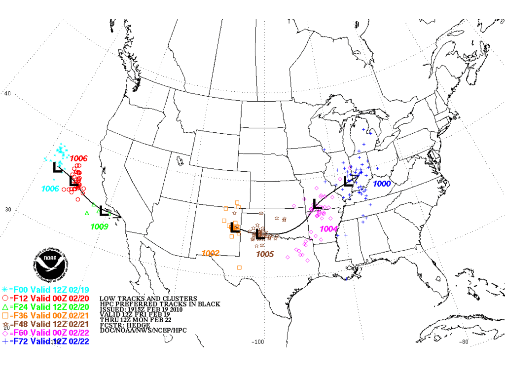
Updated Storm Tracks from HPC (19Z)...remember that it will change several times...
Carla/Alicia/Jerry(In The Eye)/Michelle/Charley/Ivan/Dennis/Katrina/Rita/Wilma/Humberto/Ike/Harvey
Member: National Weather Association
Facebook.com/Weather Infinity
Twitter @WeatherInfinity
Member: National Weather Association
Facebook.com/Weather Infinity
Twitter @WeatherInfinity
-
wxman57
- Global Moderator
- Posts: 2621
- Joined: Thu Feb 04, 2010 5:34 am
- Location: Southwest Houston (Westbury)
- Contact:
Latest GFS run indicates that the highest precip chances between Houston and Speldora would be from about 9AM to 1PM Sunday. That's a bit earlier. However, with the main energy moving across southern Oklahoma, I'd expect just some showers with maybe a thunderstorm or two.kayci wrote:Ok, lemme get this straight. There's a cold front on the way but storms are not expected to hit H-town until LATER Sunday... correct?
I'm headed out to the ranch in Splendora, TX today and will be leaving to come back to Texas City early Sunday morning. I won't see any nasty weather until then correct? Once I'm safe and WARM in Texas City, it can snow all it wants in Splendora Monday or Tuesday. I'll be back in hibernation mode.
-
wxman57
- Global Moderator
- Posts: 2621
- Joined: Thu Feb 04, 2010 5:34 am
- Location: Southwest Houston (Westbury)
- Contact:
We might explain that the chart you posted represents this weekend's low center, not the one that may produce snow in Texas next Tuesday.srainhoutx wrote:Updated Storm Tracks from HPC (19Z)...remember that it will change several times...
http://i228.photobucket.com/albums/ee29 ... k_ense.gif
-
srainhoutx
- Site Admin
- Posts: 19700
- Joined: Tue Feb 02, 2010 2:32 pm
- Location: Maggie Valley, NC
- Contact:
wxman57 wrote:We might explain that the chart you posted represents this weekend's low center, not the one that may produce snow in Texas next Tuesday.srainhoutx wrote:Updated Storm Tracks from HPC (19Z)...remember that it will change several times...
http://i228.photobucket.com/albums/ee29 ... k_ense.gif
Sorry about that wxman57. The office is busy at the moment.
http://wxweb.meteostar.com/models/noaap ... UMBLOOP=10
FYI: One more mission of RECON for the G-IV at 12Z tomorrow.
Carla/Alicia/Jerry(In The Eye)/Michelle/Charley/Ivan/Dennis/Katrina/Rita/Wilma/Humberto/Ike/Harvey
Member: National Weather Association
Facebook.com/Weather Infinity
Twitter @WeatherInfinity
Member: National Weather Association
Facebook.com/Weather Infinity
Twitter @WeatherInfinity
-
srainhoutx
- Site Admin
- Posts: 19700
- Joined: Tue Feb 02, 2010 2:32 pm
- Location: Maggie Valley, NC
- Contact:
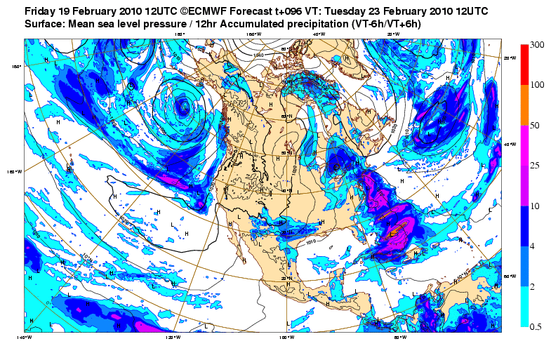
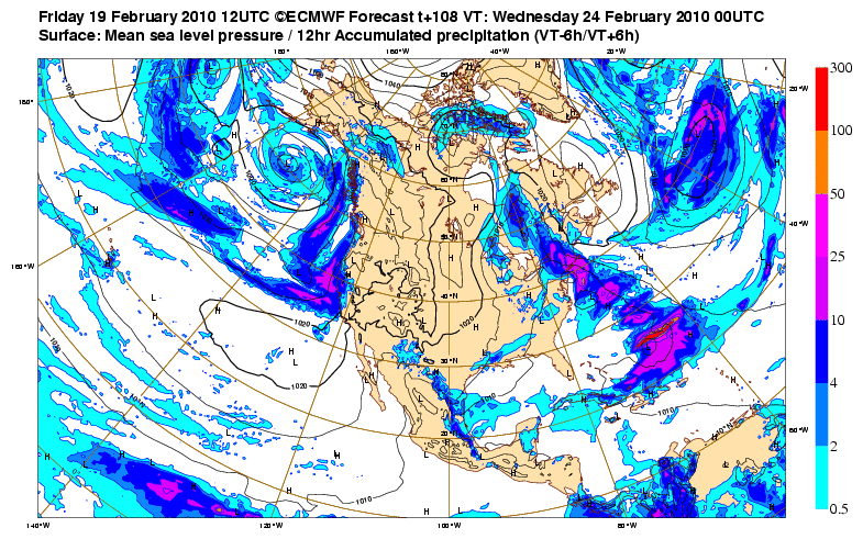
Also will add the the Free Site for the ECMWF offered a little bonus freebie today. Precip Maps...
Hour 96...
Hour 108...
Hour 96...
Hour 108...
Carla/Alicia/Jerry(In The Eye)/Michelle/Charley/Ivan/Dennis/Katrina/Rita/Wilma/Humberto/Ike/Harvey
Member: National Weather Association
Facebook.com/Weather Infinity
Twitter @WeatherInfinity
Member: National Weather Association
Facebook.com/Weather Infinity
Twitter @WeatherInfinity
-
txsnowmaker
- Posts: 733
- Joined: Wed Feb 03, 2010 4:07 pm
- Location: SW Houston (Galleria area)
- Contact:
While my part of Houston apparently isn't currently expected to receive snow of any significance next week, there is still plenty of time for model adjustments. I won't be surprised if all I get is cold rain, and I also won't be shocked if we get some snow.
-
kayci
- Posts: 358
- Joined: Thu Feb 04, 2010 10:30 am
- Location: Alvin
- Contact:
wxman57 wrote:Latest GFS run indicates that the highest precip chances between Houston and Speldora would be from about 9AM to 1PM Sunday. That's a bit earlier. However, with the main energy moving across southern Oklahoma, I'd expect just some showers with maybe a thunderstorm or two.kayci wrote:Ok, lemme get this straight. There's a cold front on the way but storms are not expected to hit H-town until LATER Sunday... correct?
I'm headed out to the ranch in Splendora, TX today and will be leaving to come back to Texas City early Sunday morning. I won't see any nasty weather until then correct? Once I'm safe and WARM in Texas City, it can snow all it wants in Splendora Monday or Tuesday. I'll be back in hibernation mode.
That is SO helpful, THANK YOU! I'll just pack up and leave about 7AM Sunday.
Thanx again.
k
-
srainhoutx
- Site Admin
- Posts: 19700
- Joined: Tue Feb 02, 2010 2:32 pm
- Location: Maggie Valley, NC
- Contact:
First hint of forecast changes from San Angelo...
.LONG TERM...
THE MODELS ARE IN BETTER AGREEMENT ON THE TIMING AND PATH OF THE
NEXT UPPER LEVEL LOW THAT THE LATEST WATER VAPOR IMAGERY SHOWS OFF
THE COAST OF SOUTHERN CALIFORNIA. THE STRONG UPPER LEVEL LOW WILL
QUICKLY MOVE EAST ACROSS SOUTHERN CALIFORNIA INTO SOUTHERN CONUS AND
THEN EAST ACROSS THE PANHANDLE OF TEXAS ON SUNDAY. STRONG
SOUTHERLY LOW LEVEL FLOW AHEAD OF THIS SYSTEM WILL ALLOW FOR GULF
MOISTURE TO MOVE INTO WEST CENTRAL TEXAS ON SATURDAY. INCREASED
POPS SLIGHTLY BUT STILL HAVE CHC TO LKLY POPS ACROSS WEST CENTRAL
TEXAS FOR SATURDAY OVERNIGHT INTO SUNDAY MORNING AS THUNDERSTORMS
ARE EXPECTED TO DEVELOP AHEAD OF A STRONG PACIFIC FRONT. THE
SHOWERS AND THUNDERSTORMS ARE EXPECTED TO MOVE QUICKLY ACROSS WEST
CENTRAL TEXAS AND SHOULD END BY LATE MORNING...EXCEPT ACROSS FAR
EASTERN PORTION OF WEST CENTRAL TEXAS WHERE SHOWERS AND
THUNDERSTORMS MAY LINGER INTO THE EARLY AFTERNOON.
A STRONG COLD FRONT IS STILL EXPECTED TO PUSH ACROSS WEST CENTRAL
TEXAS ON LATE SUNDAY INTO MONDAY. THE 12Z RUN OF THE GFS AND ECMWF
HAVE COME INTO BETTER AGREEMENT ON THE UPPER LEVEL PATTERN WITH
BOTH MODELS SHOWING AN UPPER LEVEL TROUGH APPROACHING WEST CENTRAL
TEXAS ON TUESDAY. THIS COMBINED WITH COLD AIR IN PLACE CREATES THE
POSSIBILITY OF WINTRY PRECIPITATION. THERE IS A GOOD CHANCE FOR
PRECIPITATION BUT TEMPERATURES STILL REMAIN UNCERTAIN. THE GFS
850MB TEMPERATURES REMAIN COLDER THAN THE ECMWF. THE 12Z GFS
SOUNDINGS FOR THE MOST PART HAVE SURFACE TEMPERATURES AND
DEWPOINTS HOVERING AROUND THE FREEZING MARK...EXCEPT ACROSS THE
BIG COUNTRY. ONCE AGAIN THIS IS A CASE WHERE A FEW DEGREES
DIFFERENCE IN TEMPERATURES CAN MEAN THE DIFFERENCE BETWEEN RAIN OR
SNOW FOR WEST CENTRAL TEXAS...SO WILL KEEP THE MENTION OF RAIN OR
SNOW IN THE WX GRIDS. THE MODELS ARE SHOWING QUITE A BIT OF QPF OF
TUESDAY INTO TUESDAY NIGHT...THIS COULD BECOME A CONCERN IF THE
PRECIPITATION FALLS AS SNOW. ATTM DUE TO THE UNCERTAINTY ON HOW
COLD TEMPERATURES WILL BE...WILL HOLD OFF ON PUTTING IN SNOWFALL
AMOUNTS.
FOR THE REMAINDER OF THE WORK WEEK THE MODELS HAVE DRY NORTHWEST
FLOW ALOFT ACROSS WEST CENTRAL TEXAS. TEMPERATURES WILL BE DEPENDENT
ON WHETHER OR NOT THERE IS SNOW ON THE GROUND.
Carla/Alicia/Jerry(In The Eye)/Michelle/Charley/Ivan/Dennis/Katrina/Rita/Wilma/Humberto/Ike/Harvey
Member: National Weather Association
Facebook.com/Weather Infinity
Twitter @WeatherInfinity
Member: National Weather Association
Facebook.com/Weather Infinity
Twitter @WeatherInfinity
-
srainhoutx
- Site Admin
- Posts: 19700
- Joined: Tue Feb 02, 2010 2:32 pm
- Location: Maggie Valley, NC
- Contact:
SPECIAL WEATHER STATEMENT
NATIONAL WEATHER SERVICE FORT WORTH TX
306 PM CST FRI FEB 19 2010
TXZ091>095-100>107-115>123-129>135-141>148-156>162-174-175-201100-
MONTAGUE-COOKE-GRAYSON-FANNIN-LAMAR-YOUNG-JACK-WISE-DENTON-COLLIN-
HUNT-DELTA-HOPKINS-STEPHENS-PALO PINTO-PARKER-TARRANT-DALLAS-
ROCKWALL-KAUFMAN-VAN ZANDT-RAINS-EASTLAND-ERATH-HOOD-SOMERVELL-
JOHNSON-ELLIS-HENDERSON-COMANCHE-MILLS-HAMILTON-BOSQUE-HILL-
NAVARRO-FREESTONE-ANDERSON-LAMPASAS-CORYELL-BELL-MCLENNAN-FALLS-
LIMESTONE-LEON-MILAM-ROBERTSON-
306 PM CST FRI FEB 19 2010
...THUNDERSTORMS SUNDAY FOLLOWED BY POSSIBLE WINTER WEATHER ON TUESDAY...
SHOWERS AND THUNDERSTORMS ARE EXPECTED SATURDAY NIGHT AND INTO
SUNDAY AS A SURFACE LOW PRESSURE SYSTEM DEVELOPS AND MOVES THROUGH
THE AREA. ISOLATED STRONG TO SEVERE STORMS ARE POSSIBLE EAST OF
INTERSTATE 35...WITH THE MAIN THREAT BEING LARGE HAIL. PRECIPITATION
WILL END FROM WEST TO EAST SUNDAY AFTERNOON.
AS THE SURFACE LOW EXITS THE REGION...A COLD FRONT WILL ADVANCE
ACROSS THE REGION MONDAY...DROPPING TEMPERATURES INTO THE 30S.
ANOTHER DISTURBANCE WILL MOVE THROUGH ON TUESDAY AND WITH THE COLD
AIR ALREADY IN PLACE...WINTER PRECIPITATION IS POSSIBLE. GIVEN
THE UNCERTAINTY OF THE TRACK AND STRENGTH OF THE DISTURBANCE...WE
WILL CONTINUE TO ASSESS FUTURE DATA AND UPDATE THE FORECAST AS
MORE INFORMATION BECOMES AVAILABLE.
NORTH TEXAS RESIDENTS AND MOTORISTS TRAVELING ACROSS THE REGION
ON TUESDAY SHOULD STAY INFORMED OF THE LATEST WEATHER INFORMATION
AND FORECASTS BY VISITING OUR WEBSITE AT WWW.WEATHER.GOV/FORTWORTH
Carla/Alicia/Jerry(In The Eye)/Michelle/Charley/Ivan/Dennis/Katrina/Rita/Wilma/Humberto/Ike/Harvey
Member: National Weather Association
Facebook.com/Weather Infinity
Twitter @WeatherInfinity
Member: National Weather Association
Facebook.com/Weather Infinity
Twitter @WeatherInfinity
-
srainhoutx
- Site Admin
- Posts: 19700
- Joined: Tue Feb 02, 2010 2:32 pm
- Location: Maggie Valley, NC
- Contact:
HGX thoughts...
AREA FORECAST DISCUSSION
NATIONAL WEATHER SERVICE HOUSTON/GALVESTON TX
311 PM CST FRI FEB 19 2010
.DISCUSSION...
PCPN OVER THE GULF CONTINUING TO MOVE AWAY TO THE ESE THIS AFTER-
NOON WITH SOME CLEARING NOTED OVER PARTS OF COASTAL SE TX. DEWPTS
ALSO CONTINUING TO SLOWLY CREEP UP AS THE LOWER/MID CLOUDS LINGER.
NOT EXPECTING MUCH MORE CLEARING THIS AFTN BEFORE THE CLOUDS FILL
BACK IN OVERNIGHT. THIS SHOULD RESULT IN LOW DWPT SPREADS AND THE
POSSIBILITY OF SOME PATCHY FOG OVERNIGHT/SAT MORNING. THE WEEKEND
SHOULD BRING A MIXED BAG OF SORTS. WARMER TEMPS TO PREVAIL TOMOR-
ROW/TOMORROW NIGHT ALONG WITH SOME ISO WAA -SHRA. THE MAIN ISSUES
WILL BE ON SUN WITH THE APPROACH/PASSAGE OF THE COLD FRONT. PROGS
KEEP WITH ABUNDANT MOISTURE/STRONG LIFT WITH THE FRONT/PREFRONTAL
TROF BUT THERE ARE NIGGLING QUESTIONS CONCERNING THE CAP STRENGTH
DURING THIS TIME FRAME. HOWEVER WILL OPT TO STICK WITH THE STATUS
QUO FOR NOW AS THE MODELS ARE NOT COMPELLING ENOUGH EITHER WAY.
AS FOR THE EXTENDED FCST 12Z GUIDANCE LOOKS TO BE COMING TOGETHER
TO MORE OF A CONSENSUS...BUT CONFIDENCE REMAINS VERY LOW WITH THE
EVENTUAL OUTCOME. AS IT STANDS NOW THE TRENDS POINT TO A SYNOPTIC
SCALE PATTERN WHERE A SLOWLY DEEPENING UPPER TROF (DEVELOPING AOA
THE LEE OF THE ROCKIES) PUSHES ACROSS THE SRN PLAINS BY MID WEEK.
GFS HAS BEEN THE MOST CONSISTENT OF THE BUNCH WITH THIS SCENARIO/
SOLN BUT IT HAS ALSO BEEN THE MOST INSISTENT WITH THE IDEA OF -SN
AND/OR IP FOR OUR CWFA. ECMWF REMAINS ON THE WARMER/DRIER SIDE SO
FAR. AND SO HAVING SAID ALL THAT WILL ALSO OPT FOR THE DISCRETION
AS THE BETTER PART OF VALOR CARD FOR THE LONG RANGE FCST AND KEEP
THE GRIDS AS IS FOR NOW. HOPEFULLY THESE NEXT FEW MODEL RUNS WILL
SHED A BIT MORE LIGHT/CLARITY ON THIS. 41
Carla/Alicia/Jerry(In The Eye)/Michelle/Charley/Ivan/Dennis/Katrina/Rita/Wilma/Humberto/Ike/Harvey
Member: National Weather Association
Facebook.com/Weather Infinity
Twitter @WeatherInfinity
Member: National Weather Association
Facebook.com/Weather Infinity
Twitter @WeatherInfinity
-
Portastorm

- Posts: 800
- Joined: Wed Feb 03, 2010 3:04 pm
- Location: Southwest Austin/Oak Hill, TX
- Contact:
Conservative approach from EWX but probably the best course of action as we're still four days out from a possible winter storm.
AREA FORECAST DISCUSSION
NATIONAL WEATHER SERVICE AUSTIN/SAN ANTONIO TX
334 PM CST FRI FEB 19 2010
.DISCUSSION...
GULF MOISTURE IS BACK WITH OBSERVED DEWPOINT TEMPERATURES
CURRENTLY IN THE UPPER 40S TO MID 50S ACROSS THE AREA. MOISTURE
ADVECTION WILL CONTINUE IN THE LOWER LEVELS OF THE ATMOSPHERE
PRIOR TO A PACIFIC (DRY) FRONTAL PASSAGE ON SUNDAY. UNTIL
THEN...AREAS OF NIGHTTIME AND EARLY MORNING FOG/DRIZZLE ARE
FORECAST WITH MOSTLY CLOUDY OR CLOUDY SKIES ON SATURDAY. CHANCES
FOR CONVECTION WILL BE ON THE INCREASE AHEAD OF THE FRONT LATE
SATURDAY NIGHT INTO SUNDAY...WITH THE BEST CHANCES NORTH OF THE
AUSTIN METRO AREA. ALTHOUGH SHOWERS ARE EXPECTED TO BE
PREDOMINATE...A FEW THUNDERSTORMS CAN NOT BE COMPLETELY RULED-OUT.
MOST OF THE LIFT ASSOCIATED WITH THE UPPER LEVEL SHORTWAVE TROUGH
WILL BE NORTH OF OUR AREA. ELEVATED FIRE WEATHER CONDITIONS ARE
FORECAST BEHIND THE FRONT LATE SUNDAY MORNING INTO SUNDAY
AFTERNOON ACROSS WESTERN SECTIONS OF THE CWFA AS RELATIVE
HUMIDITIES DIP TO BETWEEN 20-25 PERCENT AND 20FT WINDS INCREASE
TO AROUND 15 MPH. A COLD FRONT WILL FOLLOW DOWN ON SUNDAY
NIGHT...WITH COLD AIR ADVECTION FORECAST THROUGH MONDAY NIGHT IN
ADVANCE OF THE NEXT UPPER TROUGH. THE 12Z GFS AND ECMWF SOLUTIONS
ARE IN GOOD AGREEMENT WITH THIS UPPER LEVEL FEATURE...ALTHOUGH THE
GFS IS SLIGHTLY COLDER AND FURTHER SOUTH WITH THE UPPER LEVEL COLD
POOL. OF THE 12Z MEDIUM RANGE MODEL SOLUTIONS...THE GFS WAS MOST
AGGRESSIVE WITH RAIN CHANGING OVER TO SNOW EARLY TUESDAY AND
CONTINUING INTO TUESDAY NIGHT. OUR FORECAST TO WILL BE CLOSE TO
THE GFS...BUT WILL ADVERTISE RAIN AND/OR SNOW ACROSS THE NORTHERN
HALF OF THE AREA DUE TO LACK OF FORECAST CONFIDENCE AT THAT
PROJECTION. SNOW IS ALMOST CERTAIN NORTH OF OUR AREA BETWEEN
LUBBOCK...JUNCTION AND EAST TOWARD THE DFW METROPLEX. LITTLE-TO-NO
SNOW ACCUMULATION IS FORECAST ACROSS OUR AREA AT THIS TIME.
A DRY NORTHWEST FLOW ALOFT IS FORECAST TO PREVAIL WEDNESDAY AFTER
THE TROUGH MOVES THROUGH...THEN CONTINUE THROUGH THE END OF THE
WORK-WEEK WITH TEMPERATURES TRENDING UP TO NEAR NORMAL BY FRIDAY.
-
TexasMetBlake
- Pro Met
- Posts: 839
- Joined: Wed Feb 03, 2010 7:03 pm
- Location: Spring/Woodlands
- Contact:
18z GFS is running. Will be in the timeframe of the possible winter storm in about 20 min.
-
wxman57
- Global Moderator
- Posts: 2621
- Joined: Thu Feb 04, 2010 5:34 am
- Location: Southwest Houston (Westbury)
- Contact:
What's the link to that free ECMWF site, srain? Is that on the Penn State eWall or the actual ecmwf page?srainhoutx wrote:Also will add the the Free Site for the ECMWF offered a little bonus freebie today. Precip Maps...
Hour 96...
http://i228.photobucket.com/albums/ee29 ... h32Ame.gif
Hour 108...
http://i228.photobucket.com/albums/ee29 ... th32Am.gif
-
srainhoutx
- Site Admin
- Posts: 19700
- Joined: Tue Feb 02, 2010 2:32 pm
- Location: Maggie Valley, NC
- Contact:
Saved the link for you wxman57...wxman57 wrote:What's the link to that free ECMWF site, srain? Is that on the Penn State eWall or the actual ecmwf page?srainhoutx wrote:Also will add the the Free Site for the ECMWF offered a little bonus freebie today. Precip Maps...
Hour 96...
http://i228.photobucket.com/albums/ee29 ... h32Ame.gif
Hour 108...
http://i228.photobucket.com/albums/ee29 ... th32Am.gif
http://www.ecmwf.int/samples/d/inspect/ ... 2010021912!!/
Carla/Alicia/Jerry(In The Eye)/Michelle/Charley/Ivan/Dennis/Katrina/Rita/Wilma/Humberto/Ike/Harvey
Member: National Weather Association
Facebook.com/Weather Infinity
Twitter @WeatherInfinity
Member: National Weather Association
Facebook.com/Weather Infinity
Twitter @WeatherInfinity
-
TexasMetBlake
- Pro Met
- Posts: 839
- Joined: Wed Feb 03, 2010 7:03 pm
- Location: Spring/Woodlands
- Contact:
I think we're going to have some serious mixing issues when all this starts out--if it even happens. Anytime you get stratoform precipitation, it is indicative of warm air advection. Surface temps are going to play heck with the precip. On the flip side of the coin, the upper levels are forecast to be plenty cold enough to support snow. The hope here is the precip will cool the column enough to allow for the change over thanks to EVAP Cooling---that along with continued cold air advection.
Hey wxman, can you put together a couple of sounding for us by chance?
Hey wxman, can you put together a couple of sounding for us by chance?
Last edited by TexasMetBlake on Fri Feb 19, 2010 3:59 pm, edited 1 time in total.