
December 2015 -Year Ends As One Of Wettest On Record
-
DoctorMu

- Posts: 8031
- Joined: Sun Jun 28, 2015 11:58 am
- Location: College Station
- Contact:
-
DoctorMu
- Posts: 8031
- Joined: Sun Jun 28, 2015 11:58 am
- Location: College Station
- Contact:
rotation cited by storm tracker Bob Pack N of Navasota.
-
srainhoutx

- Site Admin

- Posts: 19700
- Joined: Tue Feb 02, 2010 2:32 pm
- Location: Maggie Valley, NC
- Contact:
Appears to have been short lived, but non the less the rotation was there. Getting some breaks in the clouds in NW Harris County with the LLJ reaching down to the surface. Winds gusting to 35 MPH the past half hour.DoctorMu wrote:rotation cited by storm tracker Bob Pack N of Navasota.
Carla/Alicia/Jerry(In The Eye)/Michelle/Charley/Ivan/Dennis/Katrina/Rita/Wilma/Humberto/Ike/Harvey
Member: National Weather Association
Facebook.com/Weather Infinity
Twitter @WeatherInfinity
Member: National Weather Association
Facebook.com/Weather Infinity
Twitter @WeatherInfinity
-
srainhoutx
- Site Admin
- Posts: 19700
- Joined: Tue Feb 02, 2010 2:32 pm
- Location: Maggie Valley, NC
- Contact:
One of the survey teams in Garland have determined that an EF-4 tornado impacted portions of that area last night. Only the second EF-4 in FWD WFO since 1950.
Carla/Alicia/Jerry(In The Eye)/Michelle/Charley/Ivan/Dennis/Katrina/Rita/Wilma/Humberto/Ike/Harvey
Member: National Weather Association
Facebook.com/Weather Infinity
Twitter @WeatherInfinity
Member: National Weather Association
Facebook.com/Weather Infinity
Twitter @WeatherInfinity
-
srainhoutx
- Site Admin
- Posts: 19700
- Joined: Tue Feb 02, 2010 2:32 pm
- Location: Maggie Valley, NC
- Contact:
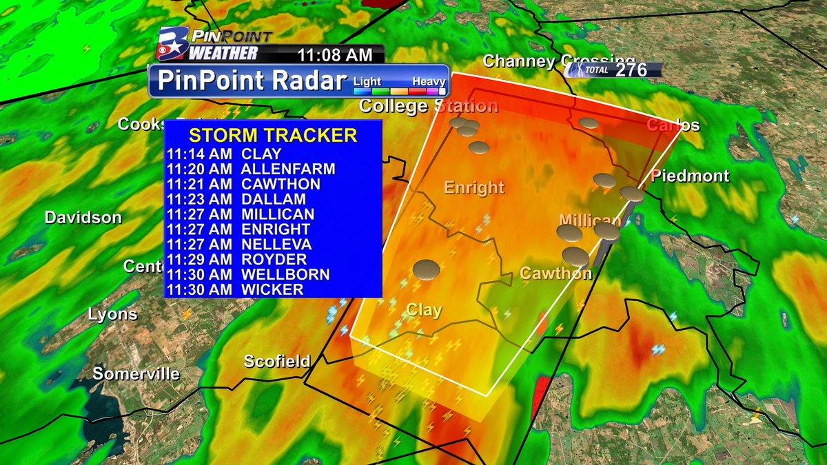
FLOOD ADVISORY
NATIONAL WEATHER SERVICE HOUSTON/GALVESTON TX
1134 AM CST SUN DEC 27 2015
BURLESON TX-WASHINGTON TX-BRAZOS TX-
1134 AM CST SUN DEC 27 2015
THE NATIONAL WEATHER SERVICE IN LEAGUE CITY HAS ISSUED A
* FLOOD ADVISORY FOR...
SOUTHEASTERN BURLESON COUNTY IN SOUTHEASTERN TEXAS...
NORTHEASTERN WASHINGTON COUNTY IN SOUTHEASTERN TEXAS...
BRAZOS COUNTY IN SOUTHEASTERN TEXAS...
* UNTIL 130 PM CST
* AT 1133 AM CST...DOPPLER RADAR INDICATED HEAVY RAIN DUE TO
THUNDERSTORMS. THIS WILL CAUSE MINOR FLOODING IN THE ADVISORY AREA.
FROM 1 TO 2 INCHES OF RAIN HAVE FALLEN. AN ADDITIONAL 1 TO 2
INCHES OF RAIN ARE POSSIBLE.
* SOME LOCATIONS THAT WILL EXPERIENCE FLOODING INCLUDE...
COLLEGE STATION...BRYAN...KURTEN...WIXON VALLEY...MILLICAN...KYLE
FIELD...WELLBORN AND INDEPENDENCE.
Carla/Alicia/Jerry(In The Eye)/Michelle/Charley/Ivan/Dennis/Katrina/Rita/Wilma/Humberto/Ike/Harvey
Member: National Weather Association
Facebook.com/Weather Infinity
Twitter @WeatherInfinity
Member: National Weather Association
Facebook.com/Weather Infinity
Twitter @WeatherInfinity
-
srainhoutx
- Site Admin
- Posts: 19700
- Joined: Tue Feb 02, 2010 2:32 pm
- Location: Maggie Valley, NC
- Contact:
FLOOD ADVISORY
NATIONAL WEATHER SERVICE HOUSTON/GALVESTON TX
1139 AM CST SUN DEC 27 2015
BURLESON TX-WASHINGTON TX-AUSTIN TX-
1139 AM CST SUN DEC 27 2015
THE NATIONAL WEATHER SERVICE IN LEAGUE CITY HAS ISSUED A
* FLOOD ADVISORY FOR...
WESTERN BURLESON COUNTY IN SOUTHEASTERN TEXAS...
SOUTHWESTERN WASHINGTON COUNTY IN SOUTHEASTERN TEXAS...
WESTERN AUSTIN COUNTY IN SOUTHEASTERN TEXAS...
* UNTIL 145 PM CST
* AT 1138 AM CST...DOPPLER RADAR INDICATED HEAVY RAIN DUE TO
THUNDERSTORMS. THIS WILL CAUSE MINOR FLOODING IN THE ADVISORY AREA.
* SOME LOCATIONS THAT WILL EXPERIENCE FLOODING INCLUDE...
CALDWELL...SHELBY...BURTON...CARMINE AND DEANVILLE.
ADDITIONAL RAINFALL OF 2 INCHES IS EXPECTED OVER THE AREA. THIS
ADDITIONAL RAIN WILL MAKE MINOR FLOODING.
Carla/Alicia/Jerry(In The Eye)/Michelle/Charley/Ivan/Dennis/Katrina/Rita/Wilma/Humberto/Ike/Harvey
Member: National Weather Association
Facebook.com/Weather Infinity
Twitter @WeatherInfinity
Member: National Weather Association
Facebook.com/Weather Infinity
Twitter @WeatherInfinity
-
srainhoutx
- Site Admin
- Posts: 19700
- Joined: Tue Feb 02, 2010 2:32 pm
- Location: Maggie Valley, NC
- Contact:
Update from Jeff:
Powerful cold front sweeping in SE TX. Temperatures range from 46 at Caldwell to 75 at Crockett.
Cold front will move across SE TX this afternoon with numerous showers and thunderstorms as lift becomes maximized. Tornado threat thus far has not been overly aggressive with only one warning near the College Station area. Heavy rainfall is actually starting to become a concern as cells continue to line up in SSW to NNE bands and train. Some areas in Austin and Washington Counties have already picked up 1-2 inches in the last hour or so.
Severe threat including tornadoes will continue east of the cold front across the warm sector. Storms still struggling to break through and deepen over the warm sector, but any that do with like become tornadic quickly. Overall think instability is just not enough to really get things going, but we are heading toward the peak of whatever modest heating we are going to get today and that could be enough to bump those parameters up a little more allowing for more sustained updrafts.
Gradient winds really ramping up at midday with surface pressures down toward 29.60in and still falling over the region. Seeing easily gusts over 35mph at many sites and likely some gusting to 40mph. Winds behind the cold front are even stronger with frequent 35-40mph gusts and a dramatic temperature drop of 25-30 degrees.
Note: Initial rating of Rowlett/Garland Tornado….widespread EF 3 damage with pockets of EF 4 damage. This would be only the second EF 4 tornado in Dallas County since 1950. Prelim track 20-40 miles long with widths of 1/8th to 1 mile. It is possible the long track is multiple tornadoes from the same supercell. 11 fatalities with over 40 injuries and at least 600 homes damaged or destroyed. 8 fatalities were in Garland with at least 3 inside vehicles which were swept off I-30 at the George Bush Turnpike interchange on the west side of Lake Ray Hubbard.
Carla/Alicia/Jerry(In The Eye)/Michelle/Charley/Ivan/Dennis/Katrina/Rita/Wilma/Humberto/Ike/Harvey
Member: National Weather Association
Facebook.com/Weather Infinity
Twitter @WeatherInfinity
Member: National Weather Association
Facebook.com/Weather Infinity
Twitter @WeatherInfinity
-
DoctorMu
- Posts: 8031
- Joined: Sun Jun 28, 2015 11:58 am
- Location: College Station
- Contact:
Power went out for a min or two and was down to a cell phone. On the NW side of the cell we sustained NNW winds of 30-35 mph, suggesting general rotation - lasted about 4 min. The buckle of cold air along the front initially enhanced rotation then undercut it.srainhoutx wrote:Appears to have been short lived, but non the less the rotation was there. Getting some breaks in the clouds in NW Harris County with the LLJ reaching down to the surface. Winds gusting to 35 MPH the past half hour.DoctorMu wrote:rotation cited by storm tracker Bob Pack N of Navasota.
-
Cromagnum
- Posts: 3065
- Joined: Thu Feb 03, 2011 10:42 pm
- Location: Georgetown
- Contact:
No surprises here. All week hype of the storm, but the cap always holds a tight lid over Houston. Not that I want storms mind you, but we seem to never see the wolves that are called for.
-
nuby3
- Posts: 387
- Joined: Mon Feb 22, 2010 10:25 pm
- Location: THE WOODLANDS PARKWAY and FM 2978
- Contact:
San Angelo reporting 34F light snow and thunder
-
DoctorMu
- Posts: 8031
- Joined: Sun Jun 28, 2015 11:58 am
- Location: College Station
- Contact:
Significant entraining continuing in the CLL area.
-
jasons2k

- Posts: 6193
- Joined: Thu Feb 04, 2010 12:54 pm
- Location: Imperial Oaks
- Contact:
I wouldn't declare that just yet. The front is crawling east and we still have a couple of hours of heating left. With some breaks in the clouds now appearing on satellite, it might be enough to bust the cap. Sometimes when these things finally trigger, it happens very quickly. There is a tremendous amount of wind energy so folks should keep a very close watch out until this is over.Cromagnum wrote:No surprises here. All week hype of the storm, but the cap always holds a tight lid over Houston. Not that I want storms mind you, but we seem to never see the wolves that are called for.
-
DoctorMu
- Posts: 8031
- Joined: Sun Jun 28, 2015 11:58 am
- Location: College Station
- Contact:
In the last 24 hours:
3.5 in of rain
-28°F temp change
3.5 in of rain
-28°F temp change
-
DoctorMu
- Posts: 8031
- Joined: Sun Jun 28, 2015 11:58 am
- Location: College Station
- Contact:
ssued by The National Weather Service
Houston/Galveston, TX
1:25pm CST, Sun Dec 27
THE NATIONAL WEATHER SERVICE IN LEAGUE CITY HAS ISSUED A
* FLOOD ADVISORY FOR... SOUTHEASTERN BURLESON COUNTY IN SOUTHEASTERN TEXAS... NORTHEASTERN WASHINGTON COUNTY IN SOUTHEASTERN TEXAS... BRAZOS COUNTY IN SOUTHEASTERN TEXAS...
* UNTIL 230 PM CST
* AT 124 PM CST... DOPPLER RADAR INDICATED HEAVY RAIN DUE TO THUNDERSTORMS. THIS WILL CAUSE MINOR FLOODING IN THE ADVISORY AREA. UP TO 3 INCHES OF RAIN HAVE FALLEN.
* SOME LOCATIONS THAT WILL EXPERIENCE FLOODING INCLUDE... COLLEGE STATION... BRYAN... KURTEN... WIXON VALLEY... MILLICAN... KYLE FIELD... WELLBORN AND INDEPENDENCE.
ADDITIONAL RAINFALL OF 1 TO 2 INCHES IS EXPECTED OVER THE AREA. THIS ADDITIONAL RAIN WILL MAKE MINOR FLOODING.
PRECAUTIONARY/PREPAREDNESS ACTIONS...
MOST FLOOD DEATHS OCCUR IN AUTOMOBILES. NEVER DRIVE YOUR VEHICLE INTO AREAS WHERE THE WATER COVERS THE ROADWAY. FLOOD WATERS ARE USUALLY DEEPER THAN THEY APPEAR. JUST ONE FOOT OF FLOWING WATER IS POWERFUL ENOUGH TO SWEEP VEHICLES OFF THE ROAD. WHEN ENCOUNTERING FLOODED ROADS MAKE THE SMART CHOICE... TURN AROUND... DONT DROWN.
TO REPORT FLOODING... HAVE THE NEAREST LAW ENFORCEMENT AGENCY RELAY YOUR REPORT TO THE NATIONAL WEATHER SERVICE FORECAST OFFICE.
&&
-
DoctorMu
- Posts: 8031
- Joined: Sun Jun 28, 2015 11:58 am
- Location: College Station
- Contact:
Band of snow crossing Junction moving toward Kerrville
-
srainhoutx
- Site Admin
- Posts: 19700
- Joined: Tue Feb 02, 2010 2:32 pm
- Location: Maggie Valley, NC
- Contact:
Folks just West of I-45 in Western Harris and Montgomery Counties may need to monitor the storms racing N ahead of the front. We had sunshine here in NW Harris County a bit ago and temperature shot up to 80F.
Carla/Alicia/Jerry(In The Eye)/Michelle/Charley/Ivan/Dennis/Katrina/Rita/Wilma/Humberto/Ike/Harvey
Member: National Weather Association
Facebook.com/Weather Infinity
Twitter @WeatherInfinity
Member: National Weather Association
Facebook.com/Weather Infinity
Twitter @WeatherInfinity
-
srainhoutx
- Site Admin
- Posts: 19700
- Joined: Tue Feb 02, 2010 2:32 pm
- Location: Maggie Valley, NC
- Contact:
HGX considering extending Tornado Watch to 7:00PM for Counties ahead of the front as better dynamics and recent development of storms across the Coastal Counties increases. They will likely extend the Watch to include some of the Coastal Tier of Counties.

Carla/Alicia/Jerry(In The Eye)/Michelle/Charley/Ivan/Dennis/Katrina/Rita/Wilma/Humberto/Ike/Harvey
Member: National Weather Association
Facebook.com/Weather Infinity
Twitter @WeatherInfinity
Member: National Weather Association
Facebook.com/Weather Infinity
Twitter @WeatherInfinity
-
srainhoutx
- Site Admin
- Posts: 19700
- Joined: Tue Feb 02, 2010 2:32 pm
- Location: Maggie Valley, NC
- Contact:
BULLETIN - IMMEDIATE BROADCAST REQUESTED
SEVERE THUNDERSTORM WARNING
NATIONAL WEATHER SERVICE HOUSTON/GALVESTON TX
230 PM CST SUN DEC 27 2015
THE NATIONAL WEATHER SERVICE IN LEAGUE CITY HAS ISSUED A
* SEVERE THUNDERSTORM WARNING FOR...
NORTHEASTERN WALKER COUNTY IN SOUTHEASTERN TEXAS...
SOUTHWESTERN TRINITY COUNTY IN SOUTHEASTERN TEXAS...
CENTRAL HOUSTON COUNTY IN SOUTHEASTERN TEXAS...
* UNTIL 300 PM CST
* AT 229 PM CST...A SEVERE THUNDERSTORM WAS LOCATED NEAR RIVERSIDE...
OR 10 MILES NORTH OF HUNTSVILLE...MOVING NORTH AT 65 MPH.
HAZARD...60 MPH WIND GUSTS.
SOURCE...RADAR INDICATED.
IMPACT...EXPECT DAMAGE TO ROOFS...SIDING AND TREES.
* LOCATIONS IMPACTED INCLUDE...
CROCKETT...TRINITY...LOVELADY...RIVERSIDE AND LATEXO.
Carla/Alicia/Jerry(In The Eye)/Michelle/Charley/Ivan/Dennis/Katrina/Rita/Wilma/Humberto/Ike/Harvey
Member: National Weather Association
Facebook.com/Weather Infinity
Twitter @WeatherInfinity
Member: National Weather Association
Facebook.com/Weather Infinity
Twitter @WeatherInfinity
-
srainhoutx
- Site Admin
- Posts: 19700
- Joined: Tue Feb 02, 2010 2:32 pm
- Location: Maggie Valley, NC
- Contact:
BULLETIN - IMMEDIATE BROADCAST REQUESTED
SEVERE THUNDERSTORM WARNING
NATIONAL WEATHER SERVICE HOUSTON/GALVESTON TX
241 PM CST SUN DEC 27 2015
THE NATIONAL WEATHER SERVICE IN LEAGUE CITY HAS ISSUED A
* SEVERE THUNDERSTORM WARNING FOR...
CENTRAL WALKER COUNTY IN SOUTHEASTERN TEXAS...
NORTHWESTERN MONTGOMERY COUNTY IN SOUTHEASTERN TEXAS...
SOUTHWESTERN TRINITY COUNTY IN SOUTHEASTERN TEXAS...
SOUTHERN HOUSTON COUNTY IN SOUTHEASTERN TEXAS...
EAST CENTRAL MADISON COUNTY IN SOUTHEASTERN TEXAS...
* UNTIL 315 PM CST
* AT 239 PM CST...A SEVERE THUNDERSTORM WAS LOCATED NEAR WILLIS...
MOVING NORTH AT 65 MPH.
HAZARD...60 MPH WIND GUSTS.
SOURCE...RADAR INDICATED.
IMPACT...EXPECT DAMAGE TO ROOFS...SIDING AND TREES.
* LOCATIONS IMPACTED INCLUDE...
NORTHWESTERN CONROE...HUNTSVILLE...WILLIS...TRINITY...PANORAMA
VILLAGE...NEW WAVERLY...MONTGOMERY...RIVERSIDE...LAKE CONROE DAM...
HUNTSVILLE STATE PARK AND CRABBS PRAIRIE.
Carla/Alicia/Jerry(In The Eye)/Michelle/Charley/Ivan/Dennis/Katrina/Rita/Wilma/Humberto/Ike/Harvey
Member: National Weather Association
Facebook.com/Weather Infinity
Twitter @WeatherInfinity
Member: National Weather Association
Facebook.com/Weather Infinity
Twitter @WeatherInfinity