Page 16 of 39
Re: October 2015 - Heavy Rainfall/Coastal Low/Flash Flood Li
Posted: Fri Oct 23, 2015 10:26 am
by unome
for those of you scouting a hotel close to the beach, please note the surge warning:
https://pbs.twimg.com/media/CSAvHCTUkAE4X2p.jpg
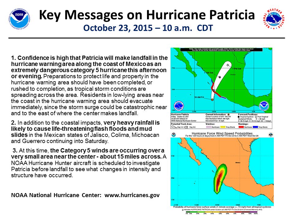
KEY MESSAGES:
1. Confidence is high that Patricia will make landfall in the
hurricane warning area along the coast of Mexico as an extremely
dangerous category 5 hurricane this afternoon or evening.
Preparations to protect life and property in the hurricane warning
area should have been completed, or rushed to completion, as
tropical storm conditions are spreading across the area.
Residents
in low-lying areas near the coast in the hurricane warning area
should evacuate immediately, since the storm surge could be
catastrophic near and to the east of where the center makes
landfall.
2. In addition to the coastal impacts,
very heavy rainfall is
likely to cause life-threatening flash floods and mud slides in the
Mexican states of Jalisco, Colima, Michoacan and Guerrero continuing
into Saturday.
3. At this time, the Category 5 winds are occurring over a very
small area near the center - about 15 miles across. A NOAA
Hurricane Hunter aircraft is scheduled to investigate Patricia
before landfall to see what changes in intensity and structure have
occurred.
Re: October 2015 - Heavy Rainfall/Coastal Low/Flash Flood Li
Posted: Fri Oct 23, 2015 10:45 am
by unome
Re: October 2015 - Heavy Rainfall/Coastal Low/Flash Flood Li
Posted: Fri Oct 23, 2015 10:48 am
by ticka1
please post results of recon when they are published
Re: October 2015 - Heavy Rainfall/Coastal Low/Flash Flood Li
Posted: Fri Oct 23, 2015 11:07 am
by unome
you'll find them live at
http://hurricanecity.com/recon/
specifically;
http://hurricanecity.com/recon/recon.cg ... m=Patricia
ticka1 wrote:
please post results of recon when they are published
Re: October 2015 - Heavy Rainfall/Coastal Low/Flash Flood Li
Posted: Fri Oct 23, 2015 11:51 am
by kitkat4me
Hello from Canada
I am from Texas, but living in Canada right now. My kids are still in Texas.
I have been watching this storm and reading the forum, thank you to all who contribute I appreciate it, and have a concern about what might be heading their way. My home is in Fort Bend area off why 6 near Sienna Plantation. Can anyone give me an idea as to how bad it might get there? I know we can pin point exactly, but trying to get information to see if I should be buying a airplane ticket and get home tomorrow morning.
All information is greatly appreciated.
Re: October 2015 - Heavy Rainfall/Coastal Low/Flash Flood Li
Posted: Fri Oct 23, 2015 12:06 pm
by unome
eye on radar

Re: October 2015 - Heavy Rainfall/Coastal Low/Flash Flood Li
Posted: Fri Oct 23, 2015 1:24 pm
by houstonia
Can someone tell me if this is the first time Texas weather, specifically, CTX, SETX has been (or is forecasted to be) so strongly affected by a Pacific storm?
Thanks.
Re: October 2015 - Heavy Rainfall/Coastal Low/Flash Flood Li
Posted: Fri Oct 23, 2015 1:25 pm
by ticka1
Just received notice that Mark Sudduth from
http://www.hurricanetrack.com will be in town tomorrow to deploy his equipment for tracking the what is left of Hurricane Patricia as she approaches SE Texas. He will be streaming on ustream if you watch his travels around the area.
Here is the link to his site:
http://hurricanetrack.com/
I will post updates once he arrives in town and starts his live streaming.
Re: October 2015 - Heavy Rainfall/Coastal Low/Flash Flood Li
Posted: Fri Oct 23, 2015 1:27 pm
by srainhoutx
Hi kitkat4me. Unless you already have travel plans back to Houston, I wouldn't worry too much about buying a ticket home to SW Houston (Ft Bend County).
Briefing from Jeff:
Flash Flood Watch issued all areas effective Saturday morning through Monday morning
Gale Watch issued all coastal waters Saturday evening into Sunday
Coastal Flood Watch issued 700pm Saturday…this will replace the coastal flood advisory at that time…upgrade to a warning is likely on Sunday.
Highlights:
Rainfall: 5-7 inches with isolated amounts of 9-12 inches
Tides: 4-5 ft above normal possibly 5-6 ft
Winds: 35-50mph offshore, 35-40mph coast, 30-40mph inland
Timing: onset of heavy rainfall midday Saturday. Conditions worsen Saturday late afternoon into overnight in Sunday.
This will not be a name tropical system…but impacts will be similar to a tropical storm
Hurricane Patricia Update:
First pass of recon shows pressure of 878mb with 61kts of wind (not a center pressure). Max flight level winds 220mph. Hurricane is likely still around 200-205mph sustained winds and should strike the coast between Puerto Vallarta and Manzanillo. Damage within 30 miles either side of the eye will be catastrophic with likely few any (even well built) buildings surviving. Northern edge eyewall will likely begin to cross the coast in the next few hours. Sustained winds of 180-200mph will last between 5-6 hours.
Re: October 2015 - Heavy Rainfall/Coastal Low/Flash Flood Li
Posted: Fri Oct 23, 2015 1:35 pm
by srainhoutx
Hopefully Jeff's update answered all the SE Texas folks questions. I'll be away for a while after some minor surgery. Great job everyone in keeping those updates coming.
Re: October 2015 - Heavy Rainfall/Coastal Low/Flash Flood Li
Posted: Fri Oct 23, 2015 2:14 pm
by ticka1
srainhoutx wrote:Hopefully Jeff's update answered all the SE Texas folks questions. I'll be away for a while after some minor surgery. Great job everyone in keeping those updates coming.
We will miss you srainhoutx - get well quickly.
Re: October 2015 - Heavy Rainfall/Coastal Low/Flash Flood Li
Posted: Fri Oct 23, 2015 2:34 pm
by srainhoutx
Update from Jeff:
Increasing confidence that SE TX is going to have some significant impacts over the weekend from a developing storm along the TX coast helped by the remains hurricane Patricia.
Main threats will be excessive rainfall and high coastal tides both of which will likely cause some degree of flooding.
Rainfall:
Confidence that heavy rainfall axis will end up somewhere across SE TX from midday Saturday to late Sunday evening or even Monday morning. Rainfall totals widespread of 5-7 inches with isolated amounts of 10-12 inches will be possible. Where exactly the heavy rain falls is still a question, but models have been trending toward the US 59 corridor including Harris County. It is still possible that the heaviest rains could remain offshore or to the NW of Harris County.
Rainfall of the expected magnitude will cause flooding even with the dry grounds. Of concern is the potential for hourly rainfall rates of 2-4 inches and this type of rainfall continuing in training bands for a few to several hours. Watersheds can handle several inches of rainfall due to the dry conditions, but amounts toward the higher end of the expect totals will likely cause some problems.
A Flash Flood Watch is in effect from Saturday morning until Monday morning.
Tides:
Still expecting tides of 4.0-5.0 ft above MLLW Saturday afternoon and evening into Sunday morning. Water levels of this heights will have impacts around Clear Lake including Nassau Bay and Clear Lake Shores as well as portions of Kemah and Seabrook. This will mainly result in street flooding and flooding under elevated structures.
Minor flooding will also be possible in Shoreacres along Taylor’s Bayou and near the Battleship Texas and the Lynchburg Ferry Landing. Elevated tides will also push northward up the lower portion of the San Jacinto River.
Any increase in the intensity of the surface low forming over the TX coastal waters will only increase these expected tides levels a little more and values of 45.0-6.0 ft are possible.
A coastal Flood Watch has been issued by the NWS to cover the possible flooding at times of high tide and this will likely be upgraded to a warning on Saturday.
HCFCD Actions:
· Clear Creek Second Outlet Gates will be opened this afternoon which will help expedite storm run-off out of Clear Lake.
· HCFCD Flood Operations Team will move to Stand By Mode at 200pm Saturday.
· HCFCD Flood Operations staff will be at Transtar effective at 200pm and at HCFCD offices effective at 600pm Saturday (possibly sooner based on conditions). 12-hr shifts will be in effect until Monday.
· Myself and Kim Jackson will support media operations at HCOEM and Karen Hastings will be helping in the JIC
· 3 HCFCD crews will be deployed at 200pm Saturday to check coastal water levels and possible flooding impacts in SE Harris County.
· HCFCD Phone Bank will be established at 600pm Saturday and can be reached at 713-684-4000
Re: October 2015 - Heavy Rainfall/Coastal Low/Flash Flood Li
Posted: Fri Oct 23, 2015 3:44 pm
by srainhoutx
Updated 5 Day QPF graphic has been issued.
Re: October 2015 - Heavy Rainfall/Coastal Low/Flash Flood Li
Posted: Fri Oct 23, 2015 4:25 pm
by Rip76
Watch out if that number verifies.
Re: October 2015 - Heavy Rainfall/Coastal Low/Flash Flood Li
Posted: Fri Oct 23, 2015 4:25 pm
by DoctorMu
srainhoutx wrote:Updated 5 Day QPF graphic has been issued.
Thanks - get well quickly!
Re: October 2015 - Heavy Rainfall/Coastal Low/Flash Flood Li
Posted: Fri Oct 23, 2015 4:48 pm
by sau27
Based on what the models are continuing to show and based on the updates from pro-mets this weekend we are for all intents and purposes looking at a weak (relative to wind) tropical storm, even though it wont technically meet the criteria to be classified as such.
Given the expected timing of this low moving by Saturday night, is it out of the question to think about a core-rain event taking place? Its not a term you hear very often but I know it can happen at night with dying tropical systems.
Re: October 2015 - Heavy Rainfall/Coastal Low/Flash Flood Li
Posted: Fri Oct 23, 2015 5:34 pm
by Katdaddy
Wow, what a historic weather day with CAT 5 Patricia being the most intense hurricane on record in the W Hemisphere. Unreal maximum winds of sustained at 200 with gust to 245 MPH earlier today. Patricia's extreme eyewall is nearing the SW MX Coast currently at 190G235MPH. Hold on tight and stay safe iCyclone Josh Morgerman. Cant imagine what you will experience during the next few hours.
For the upcoming SE TX weather this weekend the Houston-Galveston NWS state it very well "Dangerous Major Storm Event To Move Through Southeast Texas This Weekend". Patricia's energy will combine with a surface low along the TX Coast resulting in flooding rains with high rainfall rates, coastal flooding, and winds that may reach TS force in gusts along the coast. Rainfall totals forecast to average 9-12" S of I-10 to the coast with higher amounts possible. This will be a non-tropical low but it will feel like a TS. This has all the parameters in place to be a very significant event. Very heavy flooding rains will be possible across STX, S Central TX, Central TX including the Hill Country, N Central TX, NTX, ETX, NW TX, and SW LA. NTX has already seen flooding today with Flash Flooding Warning's currently in effect. This is "Turn Around Don't Drown Weekend". More info through the weekend. Stay tuned and be weather aware.
Re: October 2015 - Heavy Rainfall/Coastal Low/Flash Flood Li
Posted: Fri Oct 23, 2015 6:09 pm
by srainhoutx
As Dr. Neil will tell you, it's usually not a good thing when KHOU brings him back for the local newscast. Always good to see one of this online weather community biggest supporter. Turn on Channel 11/KHOU to get the latest.
Re: October 2015 - Heavy Rainfall/Coastal Low/Flash Flood Li
Posted: Fri Oct 23, 2015 6:20 pm
by srainhoutx
Update from Jeff:
Potentially dangerous and life threatening Flash Flood Event heading for SE TX.
Much advertised flash flood event is underway across TX. Since early this afternoon 11.6 inches of rainfall has fallen in Corsicana, TX. This clearly shows the capability of this air mass the produce “incredible” rainfall totals.
Latest guidance is now is pretty good agreement that rainfall maximum will be over SE TX and recent WPC graphics now paint an astounding maximum of 13.0 inches just south of Houston in 48 hours. A larger area of 8-12 inches includes nearly all of Harris County. Rainfall of this magnitude if it occurs as currently suggested will produce significant flash flooding and creek/bayou flooding.
Event shall commence early Saturday morning NW parts of SE TX and begin to affect the central areas in the early afternoon hours with conditions becoming hazardous and dangerous into the early and overnight hours.
Meteorologist will likely not be any more certain than now on exactly where the heavy rainfall will fall until the event is underway, but given the general decent model agreement now…much of SE TX is going to likely see some very significant totals.
No changes to tides or coastal flooding impacts at this time.
Re: October 2015 - Heavy Rainfall/Coastal Low/Flash Flood Li
Posted: Fri Oct 23, 2015 6:39 pm
by Andrew
Just a reminder that the track of the coastal low will determine where the heaviest rain will setup. We could see a rather sharp gradient, but wherever the banding features setup flooding will become an issue fast.