
To clarify, I know nothing about the science of weather other than what I follow in here. I just know historically speaking Wxman is right about these things during fall and winter. So I am playing the odds
December 2022
-
NWHouston
- Posts: 28
- Joined: Fri Aug 21, 2020 3:27 pm
- Contact:
-
MontgomeryCoWx

- Posts: 2753
- Joined: Wed Dec 14, 2011 4:31 pm
- Location: Weimar, TX
- Contact:
Well he’s going up against some highly regarded Mets who really only focus/become active during this time of year, and I’m not talking about Joe B.NWHouston wrote: ↑Fri Dec 09, 2022 9:21 amTo clarify, I know nothing about the science of weather other than what I follow in here. I just know historically speaking Wxman is right about these things during fall and winter. So I am playing the odds
Team #NeverSummer
-
MontgomeryCoWx
- Posts: 2753
- Joined: Wed Dec 14, 2011 4:31 pm
- Location: Weimar, TX
- Contact:
Yeah I see nothing across all ensembles that suggests “normal”, much less mild conditions.
Ensembles are locked and loaded.
In the words of my trading buddies, fade the contrarian.
Ensembles are locked and loaded.
In the words of my trading buddies, fade the contrarian.
Last edited by MontgomeryCoWx on Fri Dec 09, 2022 9:58 am, edited 1 time in total.
Team #NeverSummer
-
Stratton20
- Posts: 5870
- Joined: Tue Feb 09, 2021 11:35 pm
- Location: College Station, Texas
- Contact:
Even the GEFS is colder than the operational runs, its coming, now lets see if we can time that cold with a storm system and we are in business!
-
cperk
- Posts: 858
- Joined: Sun Aug 19, 2012 12:09 pm
- Location: Richmond
- Contact:
Montgomery it's like you said he likes to troll the non pro members on the board he post on and having several respected pro-mets have a different take doe not seem to matter to him.MontgomeryCoWx wrote: ↑Fri Dec 09, 2022 9:51 am Yeah I see nothing across all ensembles that suggests “normal”, much less mild conditions.
Ensembles are locked and loaded.
In the words of my trading buddies, fade the contrarian.
-
MontgomeryCoWx
- Posts: 2753
- Joined: Wed Dec 14, 2011 4:31 pm
- Location: Weimar, TX
- Contact:
I really believe he is challenging some of the non pros over there to back up their claims besides posting surface output.cperk wrote: ↑Fri Dec 09, 2022 10:16 amMontgomery it's like you said he likes to troll the non pro members on the board he post on and having several respected pro-mets have a different take doe not seem to matter to him.MontgomeryCoWx wrote: ↑Fri Dec 09, 2022 9:51 am Yeah I see nothing across all ensembles that suggests “normal”, much less mild conditions.
Ensembles are locked and loaded.
In the words of my trading buddies, fade the contrarian.
He also hedges in his message with words like “for now” and “not finding the extreme solution”… he’s not saying it won’t be chilly or cold, he’s saying he doesn’t buy the extreme solution.
The Professor over there laid it out perfectly.
Team #NeverSummer
-
cperk
- Posts: 858
- Joined: Sun Aug 19, 2012 12:09 pm
- Location: Richmond
- Contact:
Just read the Professors post and he laid it out great.MontgomeryCoWx wrote: ↑Fri Dec 09, 2022 10:19 amI really believe he is challenging some of the non pros over there to back up their claims besides posting surface output.cperk wrote: ↑Fri Dec 09, 2022 10:16 amMontgomery it's like you said he likes to troll the non pro members on the board he post on and having several respected pro-mets have a different take doe not seem to matter to him.MontgomeryCoWx wrote: ↑Fri Dec 09, 2022 9:51 am Yeah I see nothing across all ensembles that suggests “normal”, much less mild conditions.
Ensembles are locked and loaded.
In the words of my trading buddies, fade the contrarian.
He also hedges in his message with words like “for now” and “not finding the extreme solution”… he’s not saying it won’t be chilly or cold, he’s saying he doesn’t buy the extreme solution.
The Professor over there laid it out perfectly.
-
Cpv17
- Posts: 7109
- Joined: Fri Aug 31, 2018 1:58 pm
- Location: El Campo/Wharton
- Contact:
Yeah that was a good read. And for those of you that don’t know who “The Professor” is, he’s a pro met. He’s all in on the cold coming. Which backs up everything we’ve been hearing.cperk wrote: ↑Fri Dec 09, 2022 10:34 amJust read the Professors post and he laid it out great.MontgomeryCoWx wrote: ↑Fri Dec 09, 2022 10:19 amI really believe he is challenging some of the non pros over there to back up their claims besides posting surface output.
He also hedges in his message with words like “for now” and “not finding the extreme solution”… he’s not saying it won’t be chilly or cold, he’s saying he doesn’t buy the extreme solution.
The Professor over there laid it out perfectly.
-
cperk
- Posts: 858
- Joined: Sun Aug 19, 2012 12:09 pm
- Location: Richmond
- Contact:
MontgomeryCoWx i think you work in the energy sector if not feel free to correct me,but what is your take on whether the Texas power grid is ready for a really cold outbreak as is being discussed.
-
MontgomeryCoWx
- Posts: 2753
- Joined: Wed Dec 14, 2011 4:31 pm
- Location: Weimar, TX
- Contact:
I do, and we are. We fortified Nat gas compression stations and brought the ones that never made it online in the freeze, online.
It would take a more severe 2021 to challenge the grid now.
Team #NeverSummer
-
DoctorMu

- Posts: 8091
- Joined: Sun Jun 28, 2015 11:58 am
- Location: College Station
- Contact:
Thanks for confirming. That's my understanding is the NG power plants that were offline for maintenance will be online and ready.MontgomeryCoWx wrote: ↑Fri Dec 09, 2022 11:17 amI do, and we are. We fortified Nat gas compression stations and brought the ones that never made it online in the freeze, online.
It would take a more severe 2021 to challenge the grid now.
-
DoctorMu
- Posts: 8091
- Joined: Sun Jun 28, 2015 11:58 am
- Location: College Station
- Contact:
The Professor's take is somewhat similar to the discussion we had about SSW and the Ural Ridge breaking down and allowing a jailbreak of Siberian frigid air.
(all the numbers on the maps are Celsius. Thus, Siberian air = -25°F to -40°F. This scenario would give us temps in the 40s °F)
The cold is coming!
Hello old friends! It's been a while. I've been signaling this potential setup since October at my office. First highlighted the potential at our winter weather workshop. I've been pretty busy getting more involved over the last few months so it's been a lot of fun.
First I want to correct a misconception about this setup. Our source region is not the typical northwest Canada, but instead Siberia. This is a classic -EPO and -AO setup, which funnels the cold are our way. When you have just -EPO and the AO and NAO are positive the northern stream is more progressive and the cold air bleeds towards Europe. Without the -EPO but a -AO is in place the PNA and NAO become more important as a less amplified pattern allows cold to escape east and vice versa. Our source region in NW Canada is also more important in that setup. But when both come together it leads to a highly amplified pattern and cross polar flow that allows for continued shots of cold air.
Early on there may be some escape of cold air to the east so the first cold shot may be somewhat of a glancing blow "step down" we'll probably still feel the effects here in Kansas.
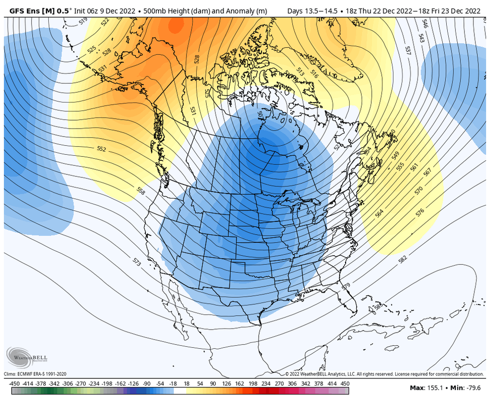
By day 11 we see the -EPO ridge and -AO force Siberian air southward. We see a new trough entering the Plains interacting with the cold. This could be the big storm before Christmas.
On Day 14 we continue to see the -EPO and -AO force cold southward. The trough has advanced further east now and some real cold would be filtering in on the back side of it.
These are the temperatures the GEFS has over Siberia so we will be dealing with -30 to -40 air. This is an ensembles mean so extremes in either direction won't be represented.
Snow cover looks good over the areas that the air parcels will travel over. Some of these areas will be getting a fresh snowpack as well. This will help limit air from modifying on its journey.
Overall it's looking to be a significant cold outbreak. Right now I think we'll see single digit lows here in Kansas at a minimum, which is way too cold for my liking. After spending 2.5 years in South I love my cold resistance I built up in Ohio. 20-30 degrees is my sweet spot. I do think there is a chance we could see historic cold, but in order for it to happen we need to have a significant snowpack develop from North Texas up to northern Nebraska. This system on Monday should have northern Nebraska covered. If we can get a large snowpack then single digit temperatures will be possible all the way down to Texas.
(all the numbers on the maps are Celsius. Thus, Siberian air = -25°F to -40°F. This scenario would give us temps in the 40s °F)
The cold is coming!
Hello old friends! It's been a while. I've been signaling this potential setup since October at my office. First highlighted the potential at our winter weather workshop. I've been pretty busy getting more involved over the last few months so it's been a lot of fun.
First I want to correct a misconception about this setup. Our source region is not the typical northwest Canada, but instead Siberia. This is a classic -EPO and -AO setup, which funnels the cold are our way. When you have just -EPO and the AO and NAO are positive the northern stream is more progressive and the cold air bleeds towards Europe. Without the -EPO but a -AO is in place the PNA and NAO become more important as a less amplified pattern allows cold to escape east and vice versa. Our source region in NW Canada is also more important in that setup. But when both come together it leads to a highly amplified pattern and cross polar flow that allows for continued shots of cold air.
Early on there may be some escape of cold air to the east so the first cold shot may be somewhat of a glancing blow "step down" we'll probably still feel the effects here in Kansas.
By day 11 we see the -EPO ridge and -AO force Siberian air southward. We see a new trough entering the Plains interacting with the cold. This could be the big storm before Christmas.
On Day 14 we continue to see the -EPO and -AO force cold southward. The trough has advanced further east now and some real cold would be filtering in on the back side of it.
These are the temperatures the GEFS has over Siberia so we will be dealing with -30 to -40 air. This is an ensembles mean so extremes in either direction won't be represented.
Snow cover looks good over the areas that the air parcels will travel over. Some of these areas will be getting a fresh snowpack as well. This will help limit air from modifying on its journey.
Overall it's looking to be a significant cold outbreak. Right now I think we'll see single digit lows here in Kansas at a minimum, which is way too cold for my liking. After spending 2.5 years in South I love my cold resistance I built up in Ohio. 20-30 degrees is my sweet spot. I do think there is a chance we could see historic cold, but in order for it to happen we need to have a significant snowpack develop from North Texas up to northern Nebraska. This system on Monday should have northern Nebraska covered. If we can get a large snowpack then single digit temperatures will be possible all the way down to Texas.
- Attachments
-
-
-
-
Last edited by DoctorMu on Fri Dec 09, 2022 11:36 am, edited 3 times in total.
-
Cpv17
- Posts: 7109
- Joined: Fri Aug 31, 2018 1:58 pm
- Location: El Campo/Wharton
- Contact:
I can’t say this enough, but if we want it to be really cold, a snowpack to our north would do the trick. We need a snowpack in eastern Wyoming, eastern Colorado, Texas panhandle, back into Oklahoma, and up to Nebraska. If we can establish a snowpack in those areas, then the extremes are definitely on the table.
With the ridge (-EPO) extending north into the Artic Circle/Artic Ocean, the jet will be able to tap into true Artic and Siberian air. This is what you want to see. Lots of times the ridging doesn’t extend far enough north of Alaska to tap into this air but this time it seems likely that it will. I see Cross-Polar Flow establishing itself being locked in and slowed down by a -AO and -NAO.
This is way out there and not guaranteed whatsoever but I’m also seeing hints of a McFarland Signature at some point setting up over the next 2-3 weeks. But very low confidence in that right now.
-
cperk
- Posts: 858
- Joined: Sun Aug 19, 2012 12:09 pm
- Location: Richmond
- Contact:
Thanks i feel much better knowing that.MontgomeryCoWx wrote: ↑Fri Dec 09, 2022 11:17 amI do, and we are. We fortified Nat gas compression stations and brought the ones that never made it online in the freeze, online.
It would take a more severe 2021 to challenge the grid now.
-
Stratton20
- Posts: 5870
- Joined: Tue Feb 09, 2021 11:35 pm
- Location: College Station, Texas
- Contact:
Cpv17 isnt a McFarland Signature pretty rare?
-
Cpv17
- Posts: 7109
- Joined: Fri Aug 31, 2018 1:58 pm
- Location: El Campo/Wharton
- Contact:
Very rare. But they are a thing of pure beauty when they do happen.
-
MontgomeryCoWx
- Posts: 2753
- Joined: Wed Dec 14, 2011 4:31 pm
- Location: Weimar, TX
- Contact:
Yes, that’s why I was preaching 40s for an extended period, but if that snowpack hits next week, we would be looking at lower, and if Cosgrove’s coastal low materializes, then all bets are off and it would turn on a fast spigot of cold air into the gulf.DoctorMu wrote: ↑Fri Dec 09, 2022 11:25 am The Professor's take is somewhat similar to the discussion we had about SSW and the Ural Ridge breaking down and allowing a jailbreak of Siberian frigid air.
(all the numbers on the maps are Celsius. Thus, Siberian air = -25°F to -40°F. This scenario would give us temps in the 40s °F)
The cold is coming!
Hello old friends! It's been a while. I've been signaling this potential setup since October at my office. First highlighted the potential at our winter weather workshop. I've been pretty busy getting more involved over the last few months so it's been a lot of fun.
First I want to correct a misconception about this setup. Our source region is not the typical northwest Canada, but instead Siberia. This is a classic -EPO and -AO setup, which funnels the cold are our way. When you have just -EPO and the AO and NAO are positive the northern stream is more progressive and the cold air bleeds towards Europe. Without the -EPO but a -AO is in place the PNA and NAO become more important as a less amplified pattern allows cold to escape east and vice versa. Our source region in NW Canada is also more important in that setup. But when both come together it leads to a highly amplified pattern and cross polar flow that allows for continued shots of cold air.
Early on there may be some escape of cold air to the east so the first cold shot may be somewhat of a glancing blow "step down" we'll probably still feel the effects here in Kansas.
By day 11 we see the -EPO ridge and -AO force Siberian air southward. We see a new trough entering the Plains interacting with the cold. This could be the big storm before Christmas.
On Day 14 we continue to see the -EPO and -AO force cold southward. The trough has advanced further east now and some real cold would be filtering in on the back side of it.
These are the temperatures the GEFS has over Siberia so we will be dealing with -30 to -40 air. This is an ensembles mean so extremes in either direction won't be represented.
Snow cover looks good over the areas that the air parcels will travel over. Some of these areas will be getting a fresh snowpack as well. This will help limit air from modifying on its journey.
Overall it's looking to be a significant cold outbreak. Right now I think we'll see single digit lows here in Kansas at a minimum, which is way too cold for my liking. After spending 2.5 years in South I love my cold resistance I built up in Ohio. 20-30 degrees is my sweet spot. I do think there is a chance we could see historic cold, but in order for it to happen we need to have a significant snowpack develop from North Texas up to northern Nebraska. This system on Monday should have northern Nebraska covered. If we can get a large snowpack then single digit temperatures will be possible all the way down to Texas.
I prefer to step down and have a long duration event below 50 with the last event being our ringer around NYE.
Team #NeverSummer
-
Cpv17
- Posts: 7109
- Joined: Fri Aug 31, 2018 1:58 pm
- Location: El Campo/Wharton
- Contact:
I don’t see how this won’t deliver. This is about a good of a setup as you can get:
-
DoctorMu
- Posts: 8091
- Joined: Sun Jun 28, 2015 11:58 am
- Location: College Station
- Contact:
-
Stratton20
- Posts: 5870
- Joined: Tue Feb 09, 2021 11:35 pm
- Location: College Station, Texas
- Contact:
Boy that 12z Euro is beautiful!