
Too early too tell if the outflow boundary will trigger any storms your way this afternoon.rnmm wrote:Hello all! Can someone please tell me what my area MAY see from these storms? I understand no one can be 100%, but I was going to fire up the grill and wanted to see what you all thought before I did that. Can we expect some storms/rain or will they dissipate before they can make it to my area or are they going to miss us all together? Thank you...I appreciate it
May Weather Discussion.
-
wxdata

- Site Admin

- Posts: 1059
- Joined: Wed Feb 03, 2010 3:04 pm
- Location: Houston, TX
- Contact:
-
wxdata
- Site Admin
- Posts: 1059
- Joined: Wed Feb 03, 2010 3:04 pm
- Location: Houston, TX
- Contact:
MESOSCALE DISCUSSION 0596
NWS STORM PREDICTION CENTER NORMAN OK
0442 PM CDT MON MAY 17 2010
AREAS AFFECTED...CNTRL TX
CONCERNING...SEVERE POTENTIAL...SEVERE THUNDERSTORM WATCH LIKELY
VALID 172142Z - 172245Z
THE GREATEST THREAT FOR LARGE HAIL AND STRONG WINDS WILL SHIFT SEWD
INTO CNTRL TX...LIKELY REQUIRING A NEW SEVERE THUNDERSTORM WATCH. A
BROKEN MULTICELL CLUSTER CURRENTLY LOCATED FROM APPROXIMATELY 20 SE
DAL TO 3O S BWD TO 10 SSW SJT WILL CONTINUE TO PROPAGATE SEWD. THE
ENVIRONMENT AHEAD OF THE LINE REMAINS VERY UNSTABLE...WITH MLCAPE
AROUND 2000-3000 J/KG. ALTHOUGH VERTICAL WIND SHEAR PROFILES ARE
RATHER WEAK...ORGANIZED CONVECTION IN THE FORM OF MULTICELL CLUSTERS
SHOULD CONTINUE TO BE MAINTAINED. ADDITIONAL THUNDERSTORMS MAY FORM
ALONG OUTFLOW BOUNDARIES FROM WEAKENING THUNDERSTORMS AHEAD OF THE
PRIMARY COLD POOL.
-
jgreak
- Posts: 96
- Joined: Sat Apr 24, 2010 8:59 am
- Location: Kingwood, Tx
- Contact:
Is the Kingwood area going to miss out on this round or is that still a possibility?
-
srainhoutx

- Site Admin
- Posts: 19700
- Joined: Tue Feb 02, 2010 2:32 pm
- Location: Maggie Valley, NC
- Contact:
We will need to watch the MCS moving into the Hill Country. That may be the storm threat for this evening. Awefully muggy in NW Harris County this afternoon.jgreak wrote:Is the Kingwood area going to miss out on this round or is that still a possibility?
Carla/Alicia/Jerry(In The Eye)/Michelle/Charley/Ivan/Dennis/Katrina/Rita/Wilma/Humberto/Ike/Harvey
Member: National Weather Association
Facebook.com/Weather Infinity
Twitter @WeatherInfinity
Member: National Weather Association
Facebook.com/Weather Infinity
Twitter @WeatherInfinity
-
wxdata
- Site Admin
- Posts: 1059
- Joined: Wed Feb 03, 2010 3:04 pm
- Location: Houston, TX
- Contact:
Unless there are a few 'homegrown' storms near you, not much heading your way at present. However, we have an unstable atmosphere with storms north of here that may affect the area later tonight.jgreak wrote:Is the Kingwood area going to miss out on this round or is that still a possibility?
-
jgreak
- Posts: 96
- Joined: Sat Apr 24, 2010 8:59 am
- Location: Kingwood, Tx
- Contact:
thanks Dan and Srain - what time are we looking at for that next round heading south?
-
rnmm
- Posts: 352
- Joined: Fri Feb 05, 2010 12:16 am
- Location: Santa Fe, Texas
- Contact:
Thank you so much wxdata...I will just go ahead and put the meat in the oven to be on the safe side! I appreciate it!wxdata wrote:Too early too tell if the outflow boundary will trigger any storms your way this afternoon.rnmm wrote:Hello all! Can someone please tell me what my area MAY see from these storms? I understand no one can be 100%, but I was going to fire up the grill and wanted to see what you all thought before I did that. Can we expect some storms/rain or will they dissipate before they can make it to my area or are they going to miss us all together? Thank you...I appreciate it
My name is Nicole and I love weather!!
~~~~~~~~~~~~~~~~~~~~~~~~~~~~~~~~~~~~~~~~~~~~~~~~~~~~~~~~~~~~~~~~~~~~~~~~~~~~~~~~~~~~~~~~~~~~~~~~
Alicia, Allison, Rita, Ike
~~~~~~~~~~~~~~~~~~~~~~~~~~~~~~~~~~~~~~~~~~~~~~~~~~~~~~~~~~~~~~~~~~~~~~~~~~~~~~~~~~~~~~~~~~~~~~~~
Alicia, Allison, Rita, Ike
-
wxdata
- Site Admin
- Posts: 1059
- Joined: Wed Feb 03, 2010 3:04 pm
- Location: Houston, TX
- Contact:
May need to backtrack a bit. There are new thunderstorms developing northwest of Brenham heading southeastward. Those storms may move our way in the next few hours. The storms near Dallas, if they hold together, will affect the metro area 10pm-ish.jgreak wrote:thanks Dan and Srain - what time are we looking at for that next round heading south?
-
rnmm
- Posts: 352
- Joined: Fri Feb 05, 2010 12:16 am
- Location: Santa Fe, Texas
- Contact:
I was just thinking we go from one extreme to the other don't we? With all this rain we should no longer be in a drought right? I know we need it though and so I will take whatever we get. Again to all the members if you are in a area that is threatened with severe weather please stay safe!
My name is Nicole and I love weather!!
~~~~~~~~~~~~~~~~~~~~~~~~~~~~~~~~~~~~~~~~~~~~~~~~~~~~~~~~~~~~~~~~~~~~~~~~~~~~~~~~~~~~~~~~~~~~~~~~
Alicia, Allison, Rita, Ike
~~~~~~~~~~~~~~~~~~~~~~~~~~~~~~~~~~~~~~~~~~~~~~~~~~~~~~~~~~~~~~~~~~~~~~~~~~~~~~~~~~~~~~~~~~~~~~~~
Alicia, Allison, Rita, Ike
-
wxdata
- Site Admin
- Posts: 1059
- Joined: Wed Feb 03, 2010 3:04 pm
- Location: Houston, TX
- Contact:
Severe Thunderstorm Watch until midnight northern half of SE TX
HGX issues Severe Thunderstorm Watch for Brazos, Burleson, Grimes, Houston, Madison, Polk, San Jacinto, Trinity, Walker, Washington [TX] till May 18, 12:00 AM CDT
HGX issues Severe Thunderstorm Watch for Brazos, Burleson, Grimes, Houston, Madison, Polk, San Jacinto, Trinity, Walker, Washington [TX] till May 18, 12:00 AM CDT
-
sleetstorm
- Posts: 651
- Joined: Thu Feb 04, 2010 12:33 pm
- Contact:
I am reporting dark storm clouds here in Baytown.
SS
SS
-
Andrew
- Site Admin
- Posts: 3508
- Joined: Wed Feb 03, 2010 9:46 pm
- Location: North-West Houston
- Contact:
I don't think the storms around Dallas will make it down here. Once the heating is gone most of the intensity should dissipate but there are still local storms and also tomorrow is another day.
For Your Infinite Source For All Things Weather Visit Our Facebook
-
wxdata
- Site Admin
- Posts: 1059
- Joined: Wed Feb 03, 2010 3:04 pm
- Location: Houston, TX
- Contact:
Aha. Few showers now developing in north central Harris behind outflow..
-
rnmm
- Posts: 352
- Joined: Fri Feb 05, 2010 12:16 am
- Location: Santa Fe, Texas
- Contact:
It is bright and shiny here in Santa Fe  It is crazy to me how just a couple of miles can make a difference in weather!
My name is Nicole and I love weather!!
~~~~~~~~~~~~~~~~~~~~~~~~~~~~~~~~~~~~~~~~~~~~~~~~~~~~~~~~~~~~~~~~~~~~~~~~~~~~~~~~~~~~~~~~~~~~~~~~
Alicia, Allison, Rita, Ike
~~~~~~~~~~~~~~~~~~~~~~~~~~~~~~~~~~~~~~~~~~~~~~~~~~~~~~~~~~~~~~~~~~~~~~~~~~~~~~~~~~~~~~~~~~~~~~~~
Alicia, Allison, Rita, Ike
-
wxdata
- Site Admin
- Posts: 1059
- Joined: Wed Feb 03, 2010 3:04 pm
- Location: Houston, TX
- Contact:
You bet! In fact the weather sensor near the Medical Center shows 91 while it's 78 in Conroe..rnmm wrote:It is bright and shiny here in Santa Fe
-
srainhoutx
- Site Admin
- Posts: 19700
- Joined: Tue Feb 02, 2010 2:32 pm
- Location: Maggie Valley, NC
- Contact:
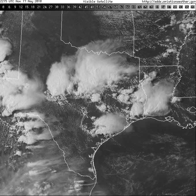
Nice VIS Image this afternoon...
Carla/Alicia/Jerry(In The Eye)/Michelle/Charley/Ivan/Dennis/Katrina/Rita/Wilma/Humberto/Ike/Harvey
Member: National Weather Association
Facebook.com/Weather Infinity
Twitter @WeatherInfinity
Member: National Weather Association
Facebook.com/Weather Infinity
Twitter @WeatherInfinity
-
rnmm
- Posts: 352
- Joined: Fri Feb 05, 2010 12:16 am
- Location: Santa Fe, Texas
- Contact:
wxdata wrote:You bet! In fact the weather sensor near the Medical Center shows 91 while it's 78 in Conroe..rnmm wrote:It is bright and shiny here in Santa Fe
Well I will take 78 over 91 any day so SEND IT MY WAY WXDATA
My name is Nicole and I love weather!!
~~~~~~~~~~~~~~~~~~~~~~~~~~~~~~~~~~~~~~~~~~~~~~~~~~~~~~~~~~~~~~~~~~~~~~~~~~~~~~~~~~~~~~~~~~~~~~~~
Alicia, Allison, Rita, Ike
~~~~~~~~~~~~~~~~~~~~~~~~~~~~~~~~~~~~~~~~~~~~~~~~~~~~~~~~~~~~~~~~~~~~~~~~~~~~~~~~~~~~~~~~~~~~~~~~
Alicia, Allison, Rita, Ike
-
wxdata
- Site Admin
- Posts: 1059
- Joined: Wed Feb 03, 2010 3:04 pm
- Location: Houston, TX
- Contact:
BULLETIN - EAS ACTIVATION REQUESTED
SEVERE THUNDERSTORM WARNING
NATIONAL WEATHER SERVICE HOUSTON/GALVESTON TX
607 PM CDT MON MAY 17 2010
THE NATIONAL WEATHER SERVICE IN LEAGUE CITY HAS ISSUED A
* SEVERE THUNDERSTORM WARNING FOR...
SOUTHEASTERN HARRIS COUNTY IN SOUTHEAST TEXAS...
* UNTIL 700 PM CDT
* AT 604 PM CDT...NATIONAL WEATHER SERVICE DOPPLER RADAR INDICATED A
SEVERE THUNDERSTORM CAPABLE OF PRODUCING QUARTER SIZE HAIL...AND
DAMAGING WINDS IN EXCESS OF 60 MPH. THIS STORM WAS LOCATED NEAR
JACINTO CITY...AND MOVING SOUTHEAST AT 10 MPH.
* LOCATIONS IN THE SEVERE THUNDERSTORM WARNING INCLUDE BUT ARE NOT
LIMITED TO MINUTE MAID PARK...ELLINGTON FIELD...SOUTH HOUSTON...
PASADENA...LA PORTE...GALENA PARK...DEER PARK...CLOVERLEAF AND
CHANNELVIEW.
-
wxdata
- Site Admin
- Posts: 1059
- Joined: Wed Feb 03, 2010 3:04 pm
- Location: Houston, TX
- Contact:
SPECIAL WEATHER STATEMENT
NATIONAL WEATHER SERVICE HOUSTON/GALVESTON TX
613 PM CDT MON MAY 17 2010
TXZ195>197-180015-
BRAZOS-BURLESON-WASHINGTON-
613 PM CDT MON MAY 17 2010
...STRONG THUNDERSTORMS OVER SOUTHERN BRAZOS AND WASHINGTON
COUNTIES...
AT 606 PM CDT...NATIONAL WEATHER SERVICE DOPPLER RADAR INDICATED A
STRONG THUNDERSTORM NEAR WELLBORN. ANOTHER CLUSTER OF STRONG
THUNDERSTORMS EXTENDED FROM INDEPENDENCE TO BRENHAM TO CARMINE. THIS
ACTIVITY WAS DRIFTING VERY SLOWLY SOUTHEAST.
PENNY SIZE HAIL...WINDS GREATER THAN 40 MPH...FREQUENT CLOUD TO
GROUND LIGHTNING...BRIEF HEAVY DOWNPOURS...ARE POSSIBLE WITH THIS
STORM.
RAINFALL AMOUNTS OF 2 TO 4 INCHES ARE LIKELY WHICH COULD LEAD TO
LOCALIZED FLOODING.
LOCATIONS IN THE PATH OF THIS STORM INCLUDE...WELLBORN...QUARRY...
MILLICAN...INDEPENDENCE...BURTON AND BRENHAM.
-
rnmm
- Posts: 352
- Joined: Fri Feb 05, 2010 12:16 am
- Location: Santa Fe, Texas
- Contact:
Do you all mind keeping me informed for a while on the weather for my area and let me know if anything is headed my way? We have got to do some things outside that just cannot wait....it is gonna take us a couple of hours...I will continue to check...Thank you so much
My name is Nicole and I love weather!!
~~~~~~~~~~~~~~~~~~~~~~~~~~~~~~~~~~~~~~~~~~~~~~~~~~~~~~~~~~~~~~~~~~~~~~~~~~~~~~~~~~~~~~~~~~~~~~~~
Alicia, Allison, Rita, Ike
~~~~~~~~~~~~~~~~~~~~~~~~~~~~~~~~~~~~~~~~~~~~~~~~~~~~~~~~~~~~~~~~~~~~~~~~~~~~~~~~~~~~~~~~~~~~~~~~
Alicia, Allison, Rita, Ike