
I'm not really sure why there are no flash flood watches in effect for at least western sections of the HGX CWA. The watch placement looks really silly with HGX standing still...Ed Mahmoud wrote:Judging from NWS local discussions and placement of flood watches, the heaviest rains tonight and tomorrow should be closer to the I-35 corridor.
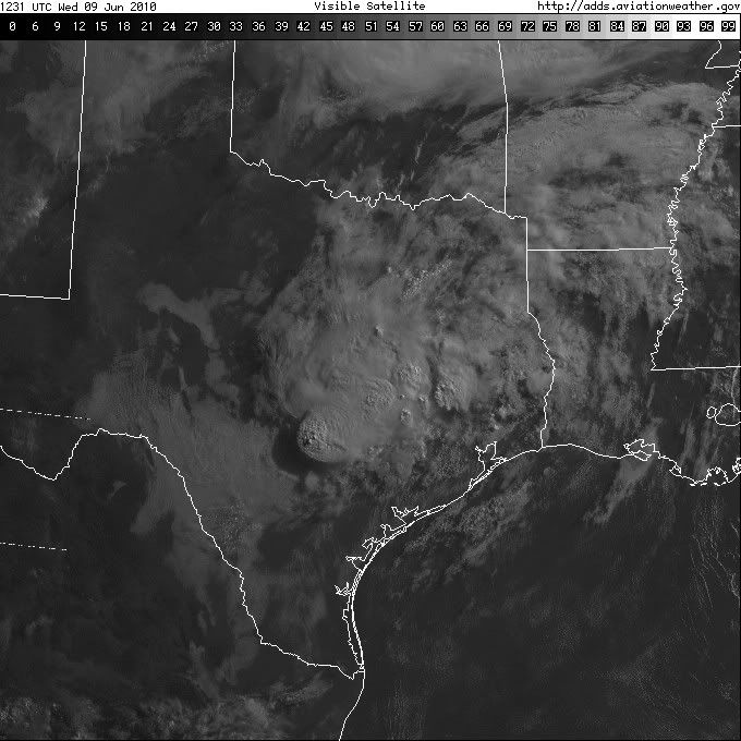
WV loop shows disturbance rotating around parent low into Southern Texas.
CRP and BRO discussions expect this to fire more storms, but other than some unimpressive showers and isolated storms NW of CRP, I'm not seeing much yet.
June Weather Discussion
-
Mr. T

- Posts: 992
- Joined: Wed Feb 03, 2010 4:22 pm
- Location: Kingwood
- Contact:
-
svrwx0503

- Pro Met

- Posts: 230
- Joined: Thu Feb 04, 2010 8:48 pm
- Location: West Harris County
- Contact:
Yeah, talk from some of the more experienced meteorologists around the office is that the hottest temps would be just to our east and northeast over Louisiana based on the today's models. We would prob see mid to upper 90s with heat indicies in the 100-105 degree range over Houston.Mr. T wrote:I noticed the difference between the GFS and Euro last week as well and never really bought the GFS solution of record heat and dry weather, but with both models showing such a ridge developing overhead for next week you may be right... I don't think the Houston area reaches 100, but definitely western and northern counties could reach 100 if we don't see any thunderstorm development or moisture levels keeping temperatures down a bit from maximum heat potential.
-
svrwx0503
- Pro Met
- Posts: 230
- Joined: Thu Feb 04, 2010 8:48 pm
- Location: West Harris County
- Contact:
Even though flash flood guidance values are still pretty high, I could see enough reason to issue a flood watch at least for our far western counties that border the EWX and FWD county warning areas as these types of setups have been notorious heavy rain producers in the past. HGX will likely jump on board and issue a watch once it becomes more clear as to where the heaviest rains are going to setup (a bear watch is in effectMr. T wrote:I'm not really sure why there are no flash flood watches in effect for at least western sections of the HGX CWA. The watch placement looks really silly with HGX standing still...
-
Mr. T
- Posts: 992
- Joined: Wed Feb 03, 2010 4:22 pm
- Location: Kingwood
- Contact:
HGX is conservative, that is for sure (a 40% chance of rain today... what the hell was that?). Flash flood guidance is definitely still high. I suppose my point was for HGX to better align with surrounding forecast office thinking, I think a flash flood watch for far western counties of SE TX, as you said, would be prudent... The way things are now, it looks a little awkward on the advisory mapsvrwx0503 wrote:Even though flash flood guidance values are still pretty high, I could see enough reason to issue a flood watch at least for our far western counties that border the EWX and FWD county warning areas as these types of setups have been notorious heavy rain producers in the past. HGX will likely jump on board and issue a watch once it becomes more clear as to where the heaviest rains are going to setup (a bear watch is in effectMr. T wrote:I'm not really sure why there are no flash flood watches in effect for at least western sections of the HGX CWA. The watch placement looks really silly with HGX standing still...)...they tend to be a bit conservative with flood watches.
The 18z GFS has a big convective bullseye across western sections of our CWA and for the EWX CWA. It is likely a convective feedback issue, with one big area of rain and a severe cut off to near nill QPF around this area, but normally this means that someone, somewhere could definitely recieve rainfall totals in excess of 5", not necessarily where the model has it outlined... I think the threat of heavy rain would also extend to the east of the bullseye (along and east of the upper low track), but that's just my opinion. Mesoscale systems like this are a tiring thing to forecast.
-
Ptarmigan

- Statistical Specialist

- Posts: 4521
- Joined: Wed Feb 03, 2010 7:20 pm
- Contact:
The Sun is out and is warming up. Quite humid. I would not be surprised if it rained again tonight. A core rain event is likely to happen, especially in areas near the low pressure system. About the tropical wave, is that the one near Dominican Republic?
-
kayci

- Posts: 358
- Joined: Thu Feb 04, 2010 10:30 am
- Location: Alvin
- Contact:
Is Galveston County in the forecast for more rain tonight? I just sprayed my yard for skeeters, hope it doesnt wash away.
-
wxdata

- Site Admin

- Posts: 1059
- Joined: Wed Feb 03, 2010 3:04 pm
- Location: Houston, TX
- Contact:
All the action continues to be west of here tonight. However these kind of tropical rain events are difficult to pinpoint where and when the next round will be.kayci wrote:Is Galveston County in the forecast for more rain tonight? I just sprayed my yard for skeeters, hope it doesnt wash away.
-
kayci
- Posts: 358
- Joined: Thu Feb 04, 2010 10:30 am
- Location: Alvin
- Contact:
Thank you, sir! you're the best!
-
weatherguy425
- Pro Met
- Posts: 830
- Joined: Wed Feb 03, 2010 7:45 pm
- Location: Atlanta, Georgia
- Contact:
There were streamers of cumulous congestus training from south to north when I was out and about around 8, maybe a sign of things to come?
-
wxdata
- Site Admin
- Posts: 1059
- Joined: Wed Feb 03, 2010 3:04 pm
- Location: Houston, TX
- Contact:
Houston's NWS is watching westweatherguy425 wrote:There were streamers of cumulous congestus training from south to north when I was out and about around 8, maybe a sign of things to come?
-
Ptarmigan
- Statistical Specialist
- Posts: 4521
- Joined: Wed Feb 03, 2010 7:20 pm
- Contact:
Something tells me it will be a long night. It is already raining southeast of San Antonio.
-
sleetstorm
- Posts: 651
- Joined: Thu Feb 04, 2010 12:33 pm
- Contact:
What are the chances of another one of those very large bow echo thunderstorms forming and moving into southeast Texas like we had late this morning until around noon?
-
Ptarmigan
- Statistical Specialist
- Posts: 4521
- Joined: Wed Feb 03, 2010 7:20 pm
- Contact:
I see what could be a core rain event near San Antonio.
-
srainhoutx

- Site Admin
- Posts: 19700
- Joined: Tue Feb 02, 2010 2:32 pm
- Location: Maggie Valley, NC
- Contact:
Another day of watching radar ahead. A core rain event is unfolding across Central TX from San Antonio to Austin where estimates of 8-10 inches of rain have fallen overnight. With a tropical airmass in place across SE TX (PW's in the 2.25 range) and temps in the upper 70's to low 80's, the stage is set for showers/storms to become active in the late morning hours. 00Z WRF guidance suggests that the best concentration of showers/storms will be in our Western Counties and HGX has issued a Flash Flood Watch for those areas...
FLOOD WATCH
NATIONAL WEATHER SERVICE HOUSTON/GALVESTON TX
457 AM CDT WED JUN 9 2010
TXZ163-176-195>198-210-211-100000-
/O.NEW.KHGX.FA.A.0002.100609T1200Z-100610T0000Z/
/00000.0.ER.000000T0000Z.000000T0000Z.000000T0000Z.OO/
AUSTIN-BRAZOS-BURLESON-COLORADO-GRIMES-HOUSTON-MADISON-WASHINGTON-
INCLUDING THE CITIES OF...BELLVILLE...BRENHAM...BRYAN...
CALDWELL...COLLEGE STATION...COLUMBUS...CROCKETT...EAGLE LAKE...
LAKE SOMERVILLE...MADISONVILLE...NAVASOTA...SEALY...WEIMAR
457 AM CDT WED JUN 9 2010
...FLOOD WATCH IN EFFECT THROUGH THIS EVENING...
THE NATIONAL WEATHER SERVICE IN HOUSTON/GALVESTON HAS ISSUED A
* FLOOD WATCH FOR A PORTION OF SOUTHEAST TEXAS...INCLUDING THE
FOLLOWING COUNTIES...AUSTIN...BRAZOS...BURLESON...COLORADO...
GRIMES...HOUSTON...MADISON AND WASHINGTON.
* THROUGH THIS EVENING
* SLOW MOVING THUNDERSTORMS ASSOCIATED WITH AN UPPER LOW OVER THE
TEXAS HILL COUNTRY WILL MOVE INTO THE AREA THIS MORNING. THESE
WILL LIKELY PERSIST INTO THE AFTERNOON.
* WIDESPREAD RAINFALL AMOUNTS OF ONE TO THREE INCHES CAN BE
EXPECTED BY THIS EVENING MAINLY ALONG AND WEST OF A LINE FROM
CROCKETT TO NAVASOTA TO COLUMBUS. LOCALLY HIGHER AMOUNTS ARE
POSSIBLE.
Carla/Alicia/Jerry(In The Eye)/Michelle/Charley/Ivan/Dennis/Katrina/Rita/Wilma/Humberto/Ike/Harvey
Member: National Weather Association
Facebook.com/Weather Infinity
Twitter @WeatherInfinity
Member: National Weather Association
Facebook.com/Weather Infinity
Twitter @WeatherInfinity
-
srainhoutx
- Site Admin
- Posts: 19700
- Joined: Tue Feb 02, 2010 2:32 pm
- Location: Maggie Valley, NC
- Contact:
Areas NE of DT San Antonio to New Braunsfels (Canyon Lake Area) have been pounded overnight as a nearly stationary storm complex continues to feed off the tropical like air mass...
FLASH FLOOD STATEMENT
NATIONAL WEATHER SERVICE AUSTIN/SAN ANTONIO TX
704 AM CDT WED JUN 9 2010
TXC029-091-187-091300-
/O.CON.KEWX.FF.W.0044.000000T0000Z-100609T1300Z/
/00000.0.ER.000000T0000Z.000000T0000Z.000000T0000Z.OO/
COMAL TX-GUADALUPE TX-BEXAR TX-
704 AM CDT WED JUN 9 2010
...A FLASH FLOOD WARNING REMAINS IN EFFECT UNTIL 800 AM CDT FOR
NORTHEASTERN BEXAR...WESTERN GUADALUPE AND COMAL COUNTIES...
AT 701 AM CDT...NATIONAL WEATHER SERVICE METEOROLOGISTS CONTINUED TO
DETECT A THUNDERSTORM PRODUCING VERY HEAVY RAIN. THIS STORM WAS
LOCATED NEAR NEW BRAUNFELS...WAS NEARLY STATIONARY. RAINFALL RATES
HAVE INCREASED TO NEAR 4 INCHES PER HOUR. THIS WILL CAUSE MAJOR
FLOODING IN THE CITY OF NEW BRAUNFELS AS STREAMS ARE ALREADY RUNNING
OUT OF BANKS OR IN FLOOD FROM EARLIER HEAVY RAINS.
OTHER LOCATIONS IN THE WARNING AREA INCLUDE WINDCREST...UNIVERSAL
CITY...TIMBERWOOD PARK...TERRELL HILLS...ST. HEDWIG...SCHERTZ...SAN
ANTONIO...OLMOS PARK...LIVE OAK...KIRBY...HOLLYWOOD PARK...HILL
COUNTRY VILLA...ALAMO HEIGHTS...SELMA...MCQUEENEY...MARION...
CIBOLO...GARDEN RIDGE AND BULVERDE.
Carla/Alicia/Jerry(In The Eye)/Michelle/Charley/Ivan/Dennis/Katrina/Rita/Wilma/Humberto/Ike/Harvey
Member: National Weather Association
Facebook.com/Weather Infinity
Twitter @WeatherInfinity
Member: National Weather Association
Facebook.com/Weather Infinity
Twitter @WeatherInfinity
-
srainhoutx
- Site Admin
- Posts: 19700
- Joined: Tue Feb 02, 2010 2:32 pm
- Location: Maggie Valley, NC
- Contact:
SPECIAL WEATHER STATEMENT
NATIONAL WEATHER SERVICE AUSTIN/SAN ANTONIO TX
710 AM CDT WED JUN 9 2010
TXZ173-189>194-205>209-220>225-091415-
WILLIAMSON-KENDALL-BLANCO-HAYS-TRAVIS-BASTROP-LEE-BEXAR-COMAL-
GUADALUPE-CALDWELL-FAYETTE-ATASCOSA-WILSON-KARNES-GONZALES-
DE WITT-LAVACA-
INCLUDING THE CITIES OF...GEORGETOWN...BOERNE...BLANCO...
SAN MARCOS...AUSTIN...BASTROP...GIDDINGS...SAN ANTONIO...
NEW BRAUNFELS...SEGUIN...LOCKHART...LA GRANGE...PLEASANTON...
FLORESVILLE...KARNES CITY...GONZALES...CUERO...HALLETTSVILLE
710 AM CDT WED JUN 9 2010
...RAINFALL AMOUNTS ACROSS COMAL COUNTY...
LISTED ARE 24 HOUR RAINFALL TOTALS COURTESY OF THE GBRA
ENDING AT 7 AM.
GBRA TOWER...3.05
STARTZVILLE...6.68
HOFFMAN ROAD...3.25
THIRD CROSSING...6.83
WAGGNER RANCH...6.15
STENEN ROAD...2.31
BEAR CREEK...10.28
SHADOW HILLS...8.29
NBU TOWER ON GERONIMO CREEK...1.34
FM 3009 ON DRY COMAL CREEK...2.78
KRUGER CANYON ROAD ON DRY COMAL CREEK...5.15
BRESKY ROAD ON ISSAC CREEK...4.47
$$
Carla/Alicia/Jerry(In The Eye)/Michelle/Charley/Ivan/Dennis/Katrina/Rita/Wilma/Humberto/Ike/Harvey
Member: National Weather Association
Facebook.com/Weather Infinity
Twitter @WeatherInfinity
Member: National Weather Association
Facebook.com/Weather Infinity
Twitter @WeatherInfinity
-
srainhoutx
- Site Admin
- Posts: 19700
- Joined: Tue Feb 02, 2010 2:32 pm
- Location: Maggie Valley, NC
- Contact:
HAZARDOUS WEATHER OUTLOOK...UPDATED
NATIONAL WEATHER SERVICE HOUSTON/GALVESTON TX
732 AM CDT WED JUN 9 2010
GMZ330-335-350-355-TXZ164-177>179-199-200-212>214-226-227-235>238-
101300-
BRAZORIA-CHAMBERS-FORT BEND-GALVESTON-GALVESTON BAY-HARRIS-
JACKSON-LIBERTY-MATAGORDA-MATAGORDA BAY-MONTGOMERY-POLK-
SAN JACINTO-TRINITY-WALKER-WALLER-
WATERS FROM FREEPORT TO THE MATAGORDA SHIP CHANNEL OUT 20 NM-
WATERS FROM HIGH ISLAND TO FREEPORT OUT 20 NM-WHARTON-
732 AM CDT WED JUN 9 2010
THIS HAZARDOUS WEATHER OUTLOOK IS FOR PORTIONS OF SOUTHEAST TEXAS.
.DAY ONE...TODAY AND TONIGHT
NUMEROUS THUNDERSTORMS ARE EXPECTED TODAY. THERE IS A SLIGHT
CHANCE FOR DAMAGING WINDS AND ISOLATED TORNADOES IN THE STRONGER
STORMS. RAINFALL AMOUNTS OF ONE TO TWO INCHES WITH ISOLATED
TOTALS UP TO THREE INCHES ARE ALSO POSSIBLE IN THE STRONGER
STORMS. SHOWERS AND THUNDERSTORMS MAY LINGER INTO THE EARLY
EVENING.
.DAY TWO...THURSDAY
SCATTERED THUNDERSTORMS ARE EXPECTED AND THERE IS A SLIGHT CHANCE
FOR DAMAGING WINDS IN THE STRONGER STORMS. RAINFALL AMOUNTS UNDER
ONE INCH ARE EXPECTED. THE SHOWERS AND THUNDERSTORMS WILL LIKELY
END BY THE EARLY EVENING.
.DAYS THREE THROUGH SEVEN...FRIDAY THROUGH TUESDAY
NO HAZARDOUS WEATHER IS EXPECTED AT THIS TIME.
.SPOTTER INFORMATION STATEMENT...
SPOTTER ACTIVATION MAY BE REQUIRED TODAY.
Carla/Alicia/Jerry(In The Eye)/Michelle/Charley/Ivan/Dennis/Katrina/Rita/Wilma/Humberto/Ike/Harvey
Member: National Weather Association
Facebook.com/Weather Infinity
Twitter @WeatherInfinity
Member: National Weather Association
Facebook.com/Weather Infinity
Twitter @WeatherInfinity
-
srainhoutx
- Site Admin
- Posts: 19700
- Joined: Tue Feb 02, 2010 2:32 pm
- Location: Maggie Valley, NC
- Contact:
I would not be surprised to see at least a Flood Advisory issued for Washington, Burleson, and Brazos Counties.
Carla/Alicia/Jerry(In The Eye)/Michelle/Charley/Ivan/Dennis/Katrina/Rita/Wilma/Humberto/Ike/Harvey
Member: National Weather Association
Facebook.com/Weather Infinity
Twitter @WeatherInfinity
Member: National Weather Association
Facebook.com/Weather Infinity
Twitter @WeatherInfinity
-
srainhoutx
- Site Admin
- Posts: 19700
- Joined: Tue Feb 02, 2010 2:32 pm
- Location: Maggie Valley, NC
- Contact:
TORNADO WARNING
TXC225-313-471-091330-
/O.NEW.KHGX.TO.W.0011.100609T1257Z-100609T1330Z/
BULLETIN - EAS ACTIVATION REQUESTED
TORNADO WARNING
NATIONAL WEATHER SERVICE HOUSTON/GALVESTON TX
757 AM CDT WED JUN 9 2010
THE NATIONAL WEATHER SERVICE IN LEAGUE CITY HAS ISSUED A
* TORNADO WARNING FOR...
SOUTHWESTERN HOUSTON COUNTY IN SOUTHEAST TEXAS...
EASTERN MADISON COUNTY IN SOUTHEAST TEXAS...
CENTRAL WALKER COUNTY IN SOUTHEAST TEXAS...
* UNTIL 830 AM CDT
* AT 751 AM CDT...NATIONAL WEATHER SERVICE DOPPLER RADAR INDICATED
A SEVERE THUNDERSTORM CAPABLE OF PRODUCING A TORNADO. THIS
TORNADO WAS LOCATED 8 MILES SOUTH OF CRABBS PRAIRIE... MOVING
NORTH AT 30 MPH.
* LOCATIONS IN THE TORNADO WARNING INCLUDE BUT ARE NOT LIMITED TO
HUNTSVILLE.
Carla/Alicia/Jerry(In The Eye)/Michelle/Charley/Ivan/Dennis/Katrina/Rita/Wilma/Humberto/Ike/Harvey
Member: National Weather Association
Facebook.com/Weather Infinity
Twitter @WeatherInfinity
Member: National Weather Association
Facebook.com/Weather Infinity
Twitter @WeatherInfinity