
June Weather Discussion
-
kayci

- Posts: 358
- Joined: Thu Feb 04, 2010 10:30 am
- Location: Alvin
- Contact:
Was caught in it and got drenched! 5 baby raccoons jumped out of the storm drain in front of my house and ran for cover under my truck, now they're all hiding under the hood in the engine compartment!!!. Is it over for the day for Galveston County? anyone?
-
wxdata

- Site Admin

- Posts: 1059
- Joined: Wed Feb 03, 2010 3:04 pm
- Location: Houston, TX
- Contact:
There's still a 'finger' for rain stretching just south of GLS. Although moving northeast, a few more showers may fall on the island in the next hour.kayci wrote:Was caught in it and got drenched! 5 baby raccoons jumped out of the storm drain in front of my house and ran for cover under my truck, now they're all hiding under the hood in the engine compartment!!!. Is it over for the day for Galveston County? anyone?
-
wxdata
- Site Admin
- Posts: 1059
- Joined: Wed Feb 03, 2010 3:04 pm
- Location: Houston, TX
- Contact:
Yikes! 12z GFS builds a 594 high over the area Sunday with temperatures heading for the 100's my Monday!
-
djjordan

- Posts: 929
- Joined: Fri Feb 05, 2010 7:19 pm
- Location: Montgomery, Texas
- Contact:
I like our cold hard freezes better LOLwxdata wrote:Yikes! 12z GFS builds a 594 high over the area Sunday with temperatures heading for the 100's my Monday!
~~~When Thunder Roars Go Indoors~~~
~~~Turn Around Don't Drown~~~
~~~Run From The Water, Hide From The Wind~~~
~~~Turn Around Don't Drown~~~
~~~Run From The Water, Hide From The Wind~~~
-
svrwx0503

- Pro Met

- Posts: 230
- Joined: Thu Feb 04, 2010 8:48 pm
- Location: West Harris County
- Contact:
Not a terrible amount of rain here at work (I-45 south and the south beltway) only 0.32'' in the rain bucket and a max wind of 25mph. It looks like things were much worse across the western part of the county so it should be interesting to see what I got at home.
Models continue to show the upper low moving very slowly north into central Texas over the next day or so with a very deep tropical fetch off the western gulf aimed right at southeast Texas...especially locations along and west of I-45. The band of showers and thunderstorms which is now moving across our far northern counties looks to be the leading edge of 2''+ PW's that are surging north across the Texas coastal bend (RUC model sounding for Hobby showed a PW of 1.76 before the storms and it has now increased to 2.27''). Flash flood guidance values are still pretty high so I wouldn't anticipate a flood watch just yet, but we will have to watch things closely.
I would expect to see redevelopment late tonight and tomorrow morning possibly a bit closer to southeast Texas as the low should be a bit further north compared to this morning.
-
sleetstorm
- Posts: 651
- Joined: Thu Feb 04, 2010 12:33 pm
- Contact:
I think that people in houston and west, west-southwest, southwest, west-northwest, received much stronger winds from that line of thunderstorms than people east of houston.
-
sleetstorm
- Posts: 651
- Joined: Thu Feb 04, 2010 12:33 pm
- Contact:
So far I have not read about anyone getting any hail from that large bow echo that came through this morning.
-
svrwx0503
- Pro Met
- Posts: 230
- Joined: Thu Feb 04, 2010 8:48 pm
- Location: West Harris County
- Contact:
Yes, that is where the apex or "peak" of the bow moved across... generally west of I-45; however there was a report of roof damage in Baytown.sleetstorm wrote:I think that people in houston and west, west-southwest, southwest, west-northwest, received much stronger winds from that line of thunderstorms than people east of houston.
-
svrwx0503
- Pro Met
- Posts: 230
- Joined: Thu Feb 04, 2010 8:48 pm
- Location: West Harris County
- Contact:
The GFS and even the NAM to a certain extent continue to peg away at the potential for some pretty significant rains along and west of I-45 over the next 24-36 hours. The 12z GFS really nails central and north Texas with a large swath of 3-6'' and isolated totals up close to 7-9'' northeast of Dallas. As is typically the case with these systems, mesoscale factors which the models handle very poorly will likely effect the location of the heaviest precip. For example, yesterday models were indicating most of the rain to be down in south Texas all day...something that did not happen as we all know, lol. I would not be terribly surprised to see at least our western counties go under a flood watch at some time over the next day or so, especially when it becomes more clear as to where the heaviest rains are going to set up.
Should be an interesting next day or so.
Should be an interesting next day or so.
-
srainhoutx

- Site Admin
- Posts: 19700
- Joined: Tue Feb 02, 2010 2:32 pm
- Location: Maggie Valley, NC
- Contact:
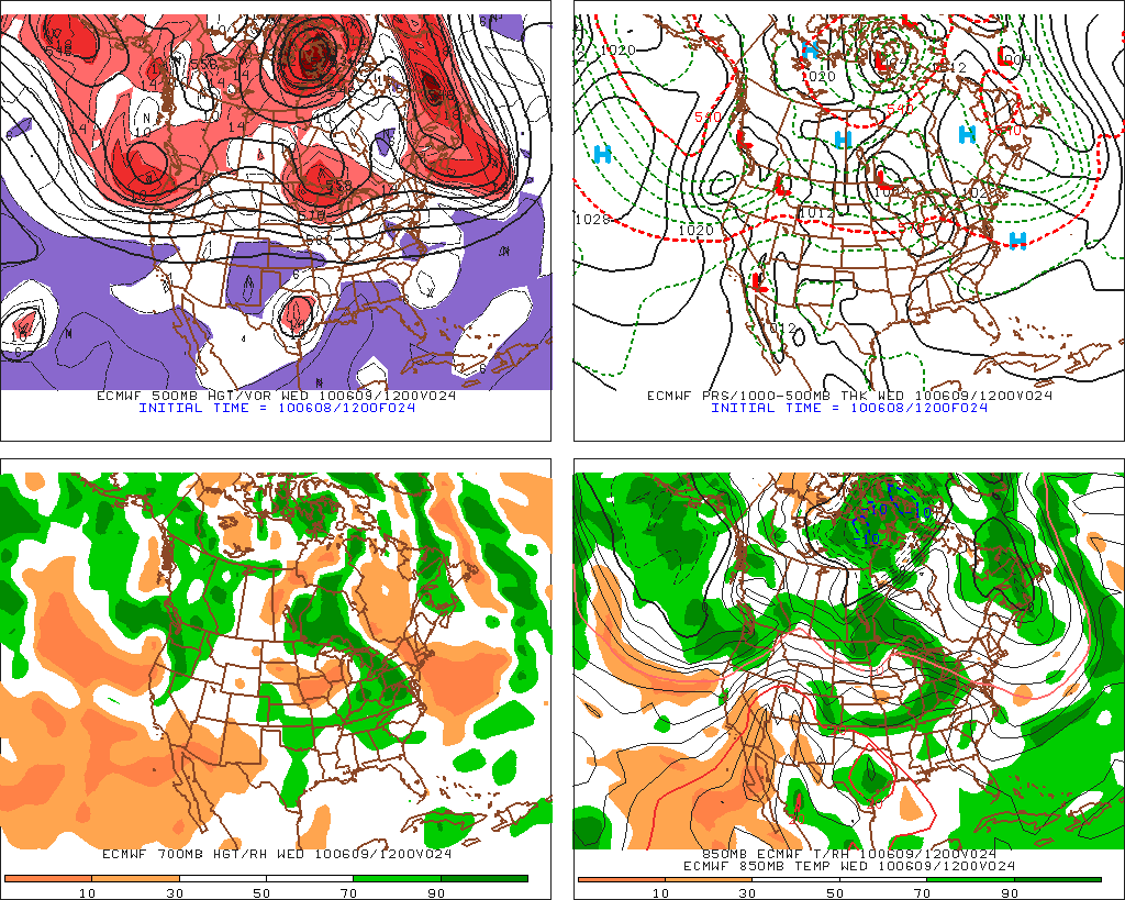
The 12Z ECMWF at hour 24...
Carla/Alicia/Jerry(In The Eye)/Michelle/Charley/Ivan/Dennis/Katrina/Rita/Wilma/Humberto/Ike/Harvey
Member: National Weather Association
Facebook.com/Weather Infinity
Twitter @WeatherInfinity
Member: National Weather Association
Facebook.com/Weather Infinity
Twitter @WeatherInfinity
-
Mr. T

- Posts: 992
- Joined: Wed Feb 03, 2010 4:22 pm
- Location: Kingwood
- Contact:
The GFS has been overdoing ridges this early summer season so far... If the GFS had its way a week ago, we'd be dry and near 105 degrees right now...wxdata wrote:Yikes! 12z GFS builds a 594 high over the area Sunday with temperatures heading for the 100's my Monday!
-
Mr. T
- Posts: 992
- Joined: Wed Feb 03, 2010 4:22 pm
- Location: Kingwood
- Contact:
IAH sure has dodged all of the rain so far this month... Weird.Ed Mahmoud wrote:Big airport only got 0.28 inches of rain with the storms.
HGX 88D storm totals seem to agree, heavy rain, but it didn't last long.
-
weatherguy425
- Pro Met
- Posts: 830
- Joined: Wed Feb 03, 2010 7:45 pm
- Location: Atlanta, Georgia
- Contact:
The low looks to be out west of San Antonio, isn't that a little further west than expected?
-
wxdata
- Site Admin
- Posts: 1059
- Joined: Wed Feb 03, 2010 3:04 pm
- Location: Houston, TX
- Contact:
I used to joke that someone was always holding their hand over the rain bucket at IAH. I don't know how many times area would rain gauges would report over an inch and here comes IAH with less than a half inch. More often than not...Mr. T wrote:IAH sure has dodged all of the rain so far this month... Weird.Ed Mahmoud wrote:Big airport only got 0.28 inches of rain with the storms.
HGX 88D storm totals seem to agree, heavy rain, but it didn't last long.
-
srainhoutx
- Site Admin
- Posts: 19700
- Joined: Tue Feb 02, 2010 2:32 pm
- Location: Maggie Valley, NC
- Contact:
weatherguy425 wrote:The low looks to be out west of San Antonio, isn't that a little further west than expected?
The Upper Low has been lingering W of Laredo for a couple of days. It does appear to be on the move now heading slowly NE.
Carla/Alicia/Jerry(In The Eye)/Michelle/Charley/Ivan/Dennis/Katrina/Rita/Wilma/Humberto/Ike/Harvey
Member: National Weather Association
Facebook.com/Weather Infinity
Twitter @WeatherInfinity
Member: National Weather Association
Facebook.com/Weather Infinity
Twitter @WeatherInfinity
-
svrwx0503
- Pro Met
- Posts: 230
- Joined: Thu Feb 04, 2010 8:48 pm
- Location: West Harris County
- Contact:
It was interesting with the high that the GFS predicted last week to be over us now was not forecast by the ECMWF which has preformed pretty well recently. Last week while GFS was forecasting possible 100 degree temps, the ECMWF was showing a weakness and developing upper low over central Texas. This time however, both GFS and the European models predict a large ridge developing over the northern gulf coast Friday before expanding and strengthening over the weekend as it moves into southeast Texas. There are some slight strength differences (ECMWF forecasting 590dam vs GFS 592dam for Monday morning) between the models, but both indicate that things could get quite hot around here...especially late in the weekend and into early next week.Mr. T wrote:The GFS has been overdoing ridges this early summer season so far... If the GFS had its way a week ago, we'd be dry and near 105 degrees right now...wxdata wrote:Yikes! 12z GFS builds a 594 high over the area Sunday with temperatures heading for the 100's my Monday!
Last edited by svrwx0503 on Tue Jun 08, 2010 4:43 pm, edited 2 times in total.
-
weatherguy425
- Pro Met
- Posts: 830
- Joined: Wed Feb 03, 2010 7:45 pm
- Location: Atlanta, Georgia
- Contact:
svrwx- there's been talk about a tropical wave impacting the W GOM early next week, do you think the ridge would be strong enough to squash out any rain chances?
-
svrwx0503
- Pro Met
- Posts: 230
- Joined: Thu Feb 04, 2010 8:48 pm
- Location: West Harris County
- Contact:
Yeah, from what the models have been showing, any tropical like system will likely be pushed well south of Texas.weatherguy425 wrote:svrwx- there's been talk about a tropical wave impacting the W GOM early next week, do you think the ridge would be strong enough to squash out any rain chances?
-
Mr. T
- Posts: 992
- Joined: Wed Feb 03, 2010 4:22 pm
- Location: Kingwood
- Contact:
I noticed the difference between the GFS and Euro last week as well and never really bought the GFS solution of record heat and dry weather, but with both models showing such a ridge developing overhead for next week you may be right... I don't think the Houston area reaches 100, but definitely western and northern counties could reach 100 if we don't see any thunderstorm development or moisture levels keeping temperatures down a bit from maximum heat potential.svrwx0503 wrote:
It was interesting with the high that the GFS predicted last week to be over us now was not forecast by the ECMWF which has preformed pretty well recently. Last week while GFS was forecasting possible 100 degree temps, the ECMWF was showing a weakness and developing upper low over central Texas. This time however, both GFS and the European models predict a large ridge developing over the northern gulf coast Friday before expanding and strengthening over the weekend as it moves into southeast Texas. There are some slight strength differences (ECMWF forecasting 590dam vs GFS 592dam for Monday morning) between the models, but both indicate that things could get quite hot around here...especially late in the weekend and into early next week. Should today's runs pan out, inland locations could see there first 100 degree day Monday.
-
srainhoutx
- Site Admin
- Posts: 19700
- Joined: Tue Feb 02, 2010 2:32 pm
- Location: Maggie Valley, NC
- Contact:
Same situation as last night. Storms are firing in Old MX NW of Del Rio and CU field increasing across S Central TX. One thing I did notice last night before bed that no showers/storms forming over the Gulf. This afternoon clouds are slowly building off Corpus. We shall see, but some folks may get alot of rainfall. As svrwx0503 mentioned earlier, models do not do well with exact placement of MCS development.
Carla/Alicia/Jerry(In The Eye)/Michelle/Charley/Ivan/Dennis/Katrina/Rita/Wilma/Humberto/Ike/Harvey
Member: National Weather Association
Facebook.com/Weather Infinity
Twitter @WeatherInfinity
Member: National Weather Association
Facebook.com/Weather Infinity
Twitter @WeatherInfinity