
Showers are beginning to pop up along a Corsicana to College Station to Rosenberg along the boundary, which has been drifting around for the past week as the cool air (now mostly drier) in the SE over performed. There's a moisture conveyer belt that reaches fro HOU to the Dakotas. Slow moving dry line approaching west Texas.
The Gulf is primed to possibly jump the gun on tropical season, along that old boundary, as we head towards the Memorial Day weekend.
May 2016: Shower/Storm Chances To End May
-
DoctorMu

- Posts: 8016
- Joined: Sun Jun 28, 2015 11:58 am
- Location: College Station
- Contact:
-
jojotheidiotclown
- Posts: 46
- Joined: Wed Apr 25, 2012 4:01 pm
- Contact:
Is this going to be the year without a summer? This rain is such a bummer. The forecast looks like rain for the foreseeable future. No high pressure with sun and fun?
-
StormOne

- Posts: 99
- Joined: Thu May 19, 2016 9:35 pm
- Location: Lincoln, NE
- Contact:
Wouldn't say that will be the case. We wondered the exact same last year and July and August were brutal for the most part.jojotheidiotclown wrote:Is this going to be the year without a summer? This rain is such a bummer. The forecast looks like rain for the foreseeable future. No high pressure with sun and fun?
A transplant from Houston to Lincoln, Nebraska.
-
djjordan

- Posts: 929
- Joined: Fri Feb 05, 2010 7:19 pm
- Location: Montgomery, Texas
- Contact:
It could be just the opposite here in Texas. Only 5 years removed from one of the worst droughts ever. Texas is truly a feast or famine state.
http://droughtmonitor.unl.edu/data/pngs ... tx_trd.png
http://droughtmonitor.unl.edu/data/pngs ... tx_trd.png
~~~When Thunder Roars Go Indoors~~~
~~~Turn Around Don't Drown~~~
~~~Run From The Water, Hide From The Wind~~~
~~~Turn Around Don't Drown~~~
~~~Run From The Water, Hide From The Wind~~~
-
djjordan
- Posts: 929
- Joined: Fri Feb 05, 2010 7:19 pm
- Location: Montgomery, Texas
- Contact:
No drought this year however. Here's the latest forecast discussion from the NWS Houston/Galveston
Area Forecast Discussion
National Weather Service Houston/Galveston TX
402 PM CDT SUN MAY 22 2016
.DISCUSSION...
Once subsequent day lower level morning inversions lift at around
15-16Z...the overall state of the regional atmosphere will one of
unconditional instability. Mid to upper level ridging will still
dominate the Southern Plains synoptic pattern through mid-week
but Texas will be on the weaker southern edge of its subsidence.
Although the subtropical jet will gradually lift north through the
first half of the work week...the highway for weak westerly disturbances
will still be open over eastern Texas. Moisture levels will still
remain at or above the 75 quartile (greater than 1.5 inch PWS) and
daily surface heating into the early afternoon middle 80s should
be enough to produce the lift...or ample buoyancy...needed to
build cumulus. Relatively lower short term precipitation chances
are based upon the larger scale influence of the upper ridge and
the surface reflection of the southeastern U.S centered high.
There are slight chances for air mass/ordinary type slow-moving
high localized rainfall rate clusters of showers with embedded
storms through Wednesday. In the event that a shortwave disturbance
does not pass by....diurnal activity will develop and evolve in
the vicinity of the local breezes. A plausible daily scenario
would be of early day nearshore or coastal county showers
developing per better sea/land speed convergence within a more
unstable and moist environment. This activity could produce
strong enough inland moving outflow boundaries that would move
into a heated and moist interior air mass that would then increase
the chance of higher convective afternoon coverage that would
persist through the early evening hours. Skies will generally be
of mid to high level overcast with occasional partly cloudy
cumulus...possible morning fog...with a persistent southeast wind.
These conditions will regulate morning temperatures to the muggy
upper 60s/low 70s inland (coastal mid 70s)...afternoon`s topping
out in the average middle to upper 80s (coastal low 80s) with any
early afternoon showers/storms keeping maximum temperatures in
check...closer to 80F. Higher 1000-500mb thickness values...along
with near 20C 850mb temperatures...has Wednesday scheduled to be
the warmest day of the week where many inland locations will reach
the lower 90s.
The Thursday weather pattern transitions to more wet. A broad long
wave trough advances east from the Rockies...placing Texas under more
diffulent flow while passing a series of more moderate disturbances
across eastern Texas. Thus...more moderate (Thursday) to likely
(Friday) POPS as the upper trough lifts northeast up into the
middle Mississippi River Valley. Overall late period conditions
may feel very familiar (yesterday?). Overcast...warm but not
overly hot nor humid (more rain cooled air?)...with periods of
clustered areas of rain and storms. 31
&&
.MARINE...
East/southeast winds will continue and gradually strengthen as low
pressure over the western high plains deepens. A moderate onshore
wind will prevail through much of the upcoming week. A long fetch of
onshore winds will produce elevated seas next week with SCEC/SCA
conditions possible. Tides will become slightly elevated early this
week and remain elevated through Friday. An unstable air mass remains
over the area which will result in periodic scattered showers and
thunderstorms over the marine area. 43
~~~When Thunder Roars Go Indoors~~~
~~~Turn Around Don't Drown~~~
~~~Run From The Water, Hide From The Wind~~~
~~~Turn Around Don't Drown~~~
~~~Run From The Water, Hide From The Wind~~~
-
TexasBreeze
- Posts: 1026
- Joined: Sun Sep 26, 2010 4:46 pm
- Location: NW Houston, TX
- Contact:
The dry weather forecasted for yesterday ended up arriving today instead. Go figure! When it looked stormy today it all went poof...
-
ticka1
- Posts: 1265
- Joined: Wed Feb 03, 2010 3:02 pm
- Location: Baytown/Mont Belvieu
- Contact:
rest of week looks dry until next weekend. Different from this morning - which had us in rain all week except tuesday and wednesday
-
Ptarmigan

- Statistical Specialist

- Posts: 4519
- Joined: Wed Feb 03, 2010 7:20 pm
- Contact:
Summers with dying El Nino can be very wet. Case in point, 1900, 1973, 1983, and 2007.jojotheidiotclown wrote:Is this going to be the year without a summer? This rain is such a bummer. The forecast looks like rain for the foreseeable future. No high pressure with sun and fun?
-
sau27
- Posts: 415
- Joined: Sat Apr 24, 2010 12:04 am
- Location: Bellaire
- Contact:
And coincidentally in each of those years a tropical system impacted the upper Texas coast.Ptarmigan wrote:Summers with dying El Nino can be very wet. Case in point, 1900, 1973, 1983, and 2007.jojotheidiotclown wrote:Is this going to be the year without a summer? This rain is such a bummer. The forecast looks like rain for the foreseeable future. No high pressure with sun and fun?
-
Rip76

- Posts: 2126
- Joined: Mon Feb 15, 2010 12:38 am
- Location: The Woodlands
- Contact:
sau27 wrote:And coincidentally in each of those years a tropical system impacted the upper Texas coast.Ptarmigan wrote:Summers with dying El Nino can be very wet. Case in point, 1900, 1973, 1983, and 2007.jojotheidiotclown wrote:Is this going to be the year without a summer? This rain is such a bummer. The forecast looks like rain for the foreseeable future. No high pressure with sun and fun?
I was just thinking the same thing.
What was 2007, Humberto?
-
srainhoutx

- Site Admin

- Posts: 19700
- Joined: Tue Feb 02, 2010 2:32 pm
- Location: Maggie Valley, NC
- Contact:
Humberto was in 2007. Boy do I remember the activity on the KHOU Weather Forum when we went to bed with an area of thunderstorms in the Bay of Campeche and woke up to a rapidly organizing Tropical Cyclone SSW of Galveston heading toward High Island. Speaking of those rapidly developing tropical systems, we will see the introduction of a new product this year in the testing phase where the National Hurricane Center may issue Watches/Warnings before a tropical cyclones forms officially when those potential threats pose a potential impact to the Coast. Last year when TS Bill well modeled to develop and no Watches/Warning were hoisted until radar and RECON data officially closed of a surface low less than 200 miles off the Middle Texas Coast showed a need for such a new approach from the National Hurricane Center. Rick Knabb and the NHC Forecasters understand the need for this since the public and State, County and Local officials need all the advance lead time they can get to protect lives and property.
Carla/Alicia/Jerry(In The Eye)/Michelle/Charley/Ivan/Dennis/Katrina/Rita/Wilma/Humberto/Ike/Harvey
Member: National Weather Association
Facebook.com/Weather Infinity
Twitter @WeatherInfinity
Member: National Weather Association
Facebook.com/Weather Infinity
Twitter @WeatherInfinity
-
Rip76
- Posts: 2126
- Joined: Mon Feb 15, 2010 12:38 am
- Location: The Woodlands
- Contact:
srainhoutx wrote:Humberto was in 2007. Boy do I remember the activity on the KHOU Weather Forum when we went to bed with an area of thunderstorms in the Bay of Campeche and woke up to a rapidly organizing Tropical Cyclone SSW of Galveston heading toward High Island.
Is there an archive of that?
I completely remember the "activity."
-
srainhoutx
- Site Admin
- Posts: 19700
- Joined: Tue Feb 02, 2010 2:32 pm
- Location: Maggie Valley, NC
- Contact:
I wish there was. Unless there is something on the internet somewhere that archived those old Topics/Weather Forum posts when the Board was on the servers of Belo Corp, I doubt it. Remember the Hurricane Ike thread? Now that was something! We had over I believe 600 pages of posts and I recall re reading that thread before the transition to our own stand alone server back in 2010 when we received our new Platform.Rip76 wrote:srainhoutx wrote:Humberto was in 2007. Boy do I remember the activity on the KHOU Weather Forum when we went to bed with an area of thunderstorms in the Bay of Campeche and woke up to a rapidly organizing Tropical Cyclone SSW of Galveston heading toward High Island.
Is there an archive of that?
I completely remember the "activity."
Carla/Alicia/Jerry(In The Eye)/Michelle/Charley/Ivan/Dennis/Katrina/Rita/Wilma/Humberto/Ike/Harvey
Member: National Weather Association
Facebook.com/Weather Infinity
Twitter @WeatherInfinity
Member: National Weather Association
Facebook.com/Weather Infinity
Twitter @WeatherInfinity
-
Rip76
- Posts: 2126
- Joined: Mon Feb 15, 2010 12:38 am
- Location: The Woodlands
- Contact:
That Hurricane Ike thread was crazy.
That other weather forum has an archive of their own "Ike" thread.
That other weather forum has an archive of their own "Ike" thread.
-
jasons2k

- Posts: 6192
- Joined: Thu Feb 04, 2010 12:54 pm
- Location: Imperial Oaks
- Contact:
If they can find an old backup, and they should have one, it should be easy to restore on the new DB Server, if they would be willing to send it. It may need to be archived as a subforum, but it would be accessible...
At one time we were concerned about losing our archives on Storm2K, but we got them secured. Plus, I have separate backups (just in case) that cover the 2004, 2005 and 2008 seasons, which were quite remarkable seasons.
At one time we were concerned about losing our archives on Storm2K, but we got them secured. Plus, I have separate backups (just in case) that cover the 2004, 2005 and 2008 seasons, which were quite remarkable seasons.
Last edited by jasons2k on Mon May 23, 2016 4:09 pm, edited 1 time in total.
-
srainhoutx
- Site Admin
- Posts: 19700
- Joined: Tue Feb 02, 2010 2:32 pm
- Location: Maggie Valley, NC
- Contact:
With the Memorial Day Holiday Weekend ahead, time to begin looking at the sensible weather forecast across the Region. Many will be heading to the Lakes and to the Beach as well as a lot of outdoor plans. The afternoon updated QPF for Thursday through Monday suggests showers and storms are possible.
- Attachments
-
-
Carla/Alicia/Jerry(In The Eye)/Michelle/Charley/Ivan/Dennis/Katrina/Rita/Wilma/Humberto/Ike/Harvey
Member: National Weather Association
Facebook.com/Weather Infinity
Twitter @WeatherInfinity
Member: National Weather Association
Facebook.com/Weather Infinity
Twitter @WeatherInfinity
-
TexasBreeze
- Posts: 1026
- Joined: Sun Sep 26, 2010 4:46 pm
- Location: NW Houston, TX
- Contact:
I found the first page of the famous Ike thread, but the results are very limited...Rip76 wrote:That Hurricane Ike thread was crazy.
That other weather forum has an archive of their own "Ike" thread.
https://web.archive.org/web/20080915021 ... hp?t=23209
-
Ptarmigan
- Statistical Specialist
- Posts: 4519
- Joined: Wed Feb 03, 2010 7:20 pm
- Contact:
I forgot Summer of 1941, which was wet. Nearly all of them had a hurricane or something tropical in nature. A wet July correlates with major hurricane making landfall.sau27 wrote:And coincidentally in each of those years a tropical system impacted the upper Texas coast.Ptarmigan wrote:Summers with dying El Nino can be very wet. Case in point, 1900, 1973, 1983, and 2007.jojotheidiotclown wrote:Is this going to be the year without a summer? This rain is such a bummer. The forecast looks like rain for the foreseeable future. No high pressure with sun and fun?
-
Katdaddy

- Global Moderator

- Posts: 2521
- Joined: Thu Feb 04, 2010 8:18 am
- Location: League City, Tx
- Contact:
Another round of severe storms across the Plains this afternoon. Only a slight chance of afternoon thunderstorms this afternoon across SE TX. Heavy rains and severe storms look to be possible Thursday and Friday across SE TX especially in areas to the NW, N, and NE of Houston metro.
- Attachments
-
-
- Screen Shot 2016-05-24 at 5.29.20 AM.png (24.32 KiB) Viewed 5695 times
-
unome
- Posts: 3062
- Joined: Fri Feb 12, 2010 6:11 pm
SPC's updated day-1 convective outlook removes the Austin area from the marginal risk
Earlier: http://www.spc.noaa.gov/products/outloo ... _1200.html
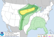
Current: http://www.spc.noaa.gov/products/outlook/day1otlk.html

hoping this cloud cover sticks around, not ready for 95+ heat indexes !

a broader view:

Earlier: http://www.spc.noaa.gov/products/outloo ... _1200.html
Current: http://www.spc.noaa.gov/products/outlook/day1otlk.html
hoping this cloud cover sticks around, not ready for 95+ heat indexes !
a broader view: