Re: April Weather Discussion. MS 150 Forecast
Posted: Wed Apr 14, 2010 9:14 pm
Axis of heavy rain moving ever so closer to SETX, also noticing some WWA showers down in our SW zones.
Your Infinite Source For All Things Weather
https://www.wxinfinity.com/
wxdata wrote:HPC's 0z QPF is still not that bullish on rain here in the Houston metro area with half inch or lessbiggerbyte wrote:Yes, it sure looks like we could. This is a change from the past few days. I would not expect the kind of rain potential we'll see west and south of the Houston area, but things look much better for many to get in
on some action.
Plus deeper Gulf moisture...Ed Mahmoud wrote:I think another spritz has hit my house, and it seems like just a little sunshine is all that is needed to spark little popcorn showers locally.
Hmmmmmmm, core rain. Core rains happen at night because of a warm low pressure and a cooler surrounding.srainhoutx wrote:Interesting discussion from Austin/San Antonio...
AREA FORECAST DISCUSSION
NATIONAL WEATHER SERVICE AUSTIN/SAN ANTONIO TX
409 PM CDT THU APR 15 2010
.DISCUSSION...
BRIEF DISCUSSION TODAY DUE TO ONGOING WEATHER. THE SLOW MOVING MCS
IS WEAKENING...AND CONVECTION IS REFORMING/FOCUSING NEAR THE UPPER
LOW OVER THE TRANS-PECOS...VERY SIMILAR TO CORE FOCUSING IN A
TROPICAL SYSTEM. THUS EXPECT RAIN TO TAPER OFF OVER OUR AREA OVER
THE NEXT 4 HOURS. MOIST GULF FLOW AND PW AROUND 2 STANDARD
DEVIATIONS ABOVE NORMAL WILL BE ENOUGH TO MAINTAIN SCATTERED LIGHT
RAIN OVERNIGHT.
OTHERWISE...STRONG UPPER LEVEL DIFFLUENCE SEEN IN WATER VAPOR
IMAGERY WILL WANE AFTER TONIGHT...RETURNING SOUTH CENTRAL TEXAS TO
UNSEASONABLY COOL AND HUMID SURFACE CONDITIONS...WITH A
CONDITIONALLY UNSTABLE SUPPORTING MOSTLY AFTERNOON THROUGH EARLY
EVENING WEAK CONVECTION THROUGH SUNDAY. TOTAL QPF FOR THE NEXT
THREE DAYS WILL RANGE FROM 1/2 TO 2 INCHES...BUT IT WILL COME IN
1/4 TO 1/2 INCH SPURTS. THE GFS HAS A GOOD HANDLE ON THE SYNOPTIC
PATTERN...BUT TIMING MESOSCALE FORCING IS NEARLY IMPOSSIBLE BEYOND
THE NEXT 6-12 HOURS. IN SHORT...ANYONE PLANNING OUTDOOR
ACTIVITIES THIS WEEKEND SHOULD BE PREPARED FOR PERIODS OF LIGHT TO
MODERATE RAIN.
I hope so...wxdata wrote:West Texas turns into a lake; rainfall totals for metro Houston stay puny; a portend for summer?
djjordan wrote:Radar showing that core rainfall nicely right now. Storm is nearly stationary!!!!!!
http://radar.weather.gov/radar.php?rid= ... 11&loop=no
BULLETIN - EAS ACTIVATION REQUESTED
FLASH FLOOD WARNING
NATIONAL WEATHER SERVICE CORPUS CHRISTI TX
112 AM CDT FRI APR 16 2010
THE NATIONAL WEATHER SERVICE IN CORPUS CHRISTI HAS ISSUED A
* FLASH FLOOD WARNING FOR...
NORTHEASTERN MCMULLEN COUNTY IN SOUTH TEXAS...
* UNTIL 415 AM CDT
* AT 107 AM CDT...NATIONAL WEATHER SERVICE DOPPLER RADAR INDICATED
SHOWERS AND THUNDERSTORMS PRODUCING TORRENTIAL RAINFALL ACROSS THE
WARNED AREA. DOPPLER RADAR HAS ESTIMATED BETWEEN 7 AND 10 INCHES OF
RAIN HAS FALLEN. THESE SHOWERS AND THUNDERSTORMS ARE NEARLY
STATIONARY...AND ANOTHER 3 TO 5 INCHES WILL OCCUR ACROSS
NORTHEASTERN MCMULLEN COUNTY.
* SLOW MOVING THUNDERSTORMS ARE PRODUCING TORRENTIAL RAINFALL IN THE
WARNED AREA. RUNOFF FROM THIS EXCESSIVE RAINFALL WILL CAUSE
FLOODING TO OCCUR. SOME LOCATIONS THAT WILL EXPERIENCE FLOODING
INCLUDE...TILDEN...CALLIHAM...CROSS AND CROWTHER.
PRECAUTIONARY/PREPAREDNESS ACTIONS...
EXCESSIVE RUNOFF FROM HEAVY RAINFALL WILL CAUSE FLOODING OF SMALL
CREEKS AND STREAMS...COUNTRY ROADS...AS WELL AS FARMLAND ALONG THE
BANKS OF CREEKS AND STREAMS.
BE ESPECIALLY CAUTIOUS AT NIGHT WHEN IT IS HARDER TO RECOGNIZE THE
DANGERS OF FLOODING. IF FLASH FLOODING IS OBSERVED ACT QUICKLY. MOVE
UP TO HIGHER GROUND TO ESCAPE FLOOD WATERS. DO NOT STAY IN AREAS
SUBJECT TO FLOODING WHEN WATER BEGINS RISING.
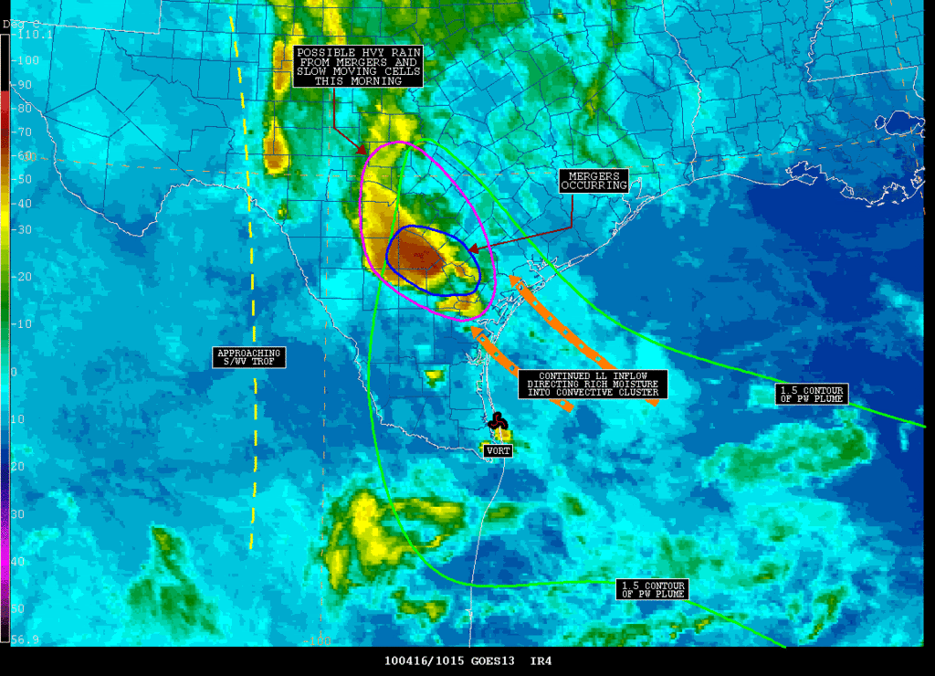
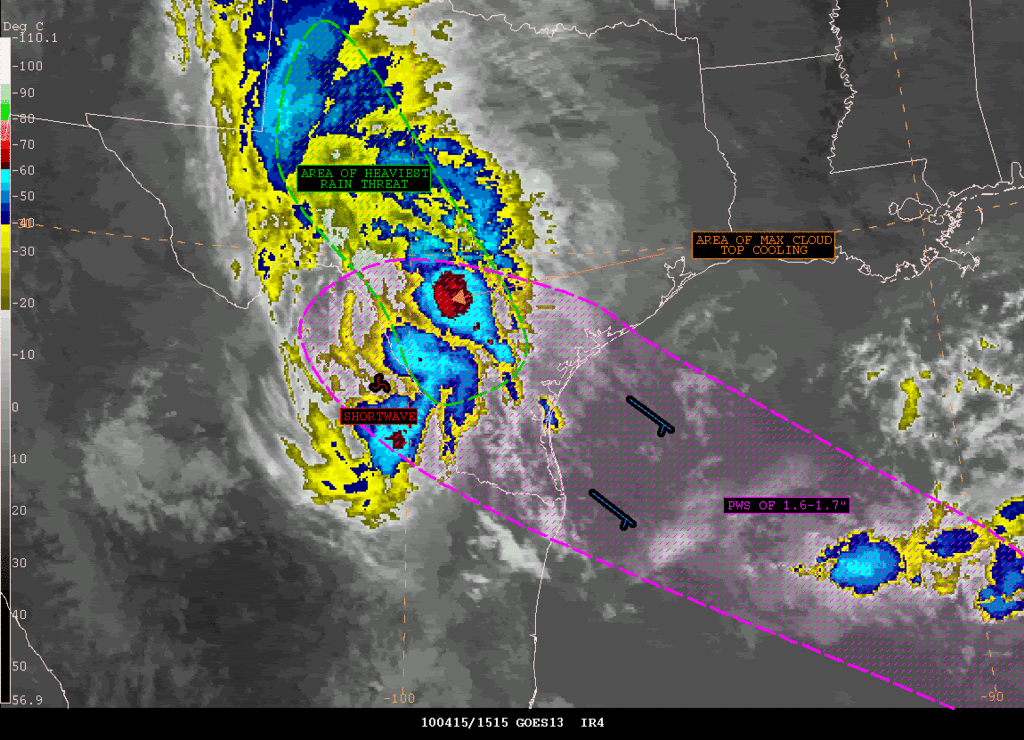
Incredible rains fall over SC TX overnight. Since late yesterday afternoon 12-15 inches of rain has fallen over Live Oak and McMullen counties south of San Antonio and NW of Corpus Christi leading is widespread significant flooding. Mid level vort max along with deep moist Gulf inflow developed a quasi-stationary MCS which remained favorably parked over this small area all night. Over the past few hours the axis/core of the rainfall as shifted slightly eastward to just west of Victoria. Additionally, heavy rainfall has occurred over WC and portions of C TX leading to rapid rises on area watersheds and rivers including the: Frio, Sabinal, upper Colorado, Medina, Rio Grande, and Guadalupe.
850mb ridge over the SE US is keeping SE TX on the far eastern edge of the wet pattern over C and S TX with most activity yesterday west of I-45. Will likely see less activity today as ridge builds slightly from the east and deeper moisture is shunted westward. Starting Saturday the GFS begins to break down the ridge on its western flank allowing rich tropical moisture to move into the area while the NAM is almost completely dry. Will trend toward the wetter GFS solution especially for our western and SW zones where the deep moisture axis is already on the doorstep. Meso scale nature of the evolving pattern to our immediate west could easily rapidly raise or lower rain chances over the weekend and while Sunday is looking the wettest, just about any time will be susceptible to streamers moving in off the Gulf.
Will go ahead and aim a general 1-2 inches at our western counties, but given PWS of 1.8+ inches at CRP which is pushing 200% of normal for mid April and what happened overnight gives pause for concern in such a moist environment. Any training or quasi-stationary bands/clusters will quickly lead to significant rainfall under the deeper moisture axis. Meso scale pattern and axis of this moisture results in little skill or confidence is where to add higher QPF totals although our western counties from CLL to VCT would look like a good bet for today into Saturday and then possible W of I-45 for Sunday.
MS150 Riders:
The good news is that Saturday will feature a decent 10-15mph tailwind (ESE to SE winds of 10-15mph), bad news is there will be showers especially once west of Houston. Greatest rain chances will likely come Saturday afternoon/evening from Sealy on westward. Weak frontal boundary may shift winds around to the NE at 5-10mph for Sunday, but is such a chaotic weak wind pattern it is hard to tell if the front actually makes it to Austin on Sunday. This will also have a big impact on rain chances as drier air north of the front attempts to make inroads into the region. Not as bad as last year, but it will be wet in spots.