
I notice some severe thunderstorms west of San Antonio. I think a MCS might be developing there.sleetstorm wrote:Ptarmigan, I noticed two severe thunderstorms that look like they may be moving in your direction. I saw them in motion on KHOU's Dopplar Radar and I saw not only the hues purple and magenta, but also dark blue, light blue, and I think that there was even some white in the coldest cloud tops.
May Weather Discussion.
-
Ptarmigan

- Statistical Specialist

- Posts: 4519
- Joined: Wed Feb 03, 2010 7:20 pm
- Contact:
-
Ptarmigan
- Statistical Specialist
- Posts: 4519
- Joined: Wed Feb 03, 2010 7:20 pm
- Contact:
I notice the Sun is out and it is humid. I wonder if that could lead to more storms later tonight.
-
sleetstorm
- Posts: 651
- Joined: Thu Feb 04, 2010 12:33 pm
- Contact:
Have any of you noticed the dark blue, light blue, and white in the center of that thunderstorm on KHOU's Dopplar Radar, yet?
-
sleetstorm
- Posts: 651
- Joined: Thu Feb 04, 2010 12:33 pm
- Contact:
Does that connote that severe thunderstorms will become more of an issue that we could be receiving more in way of severe thunderstorms rather than just heavy rain, srainhoutx?srainhoutx wrote:
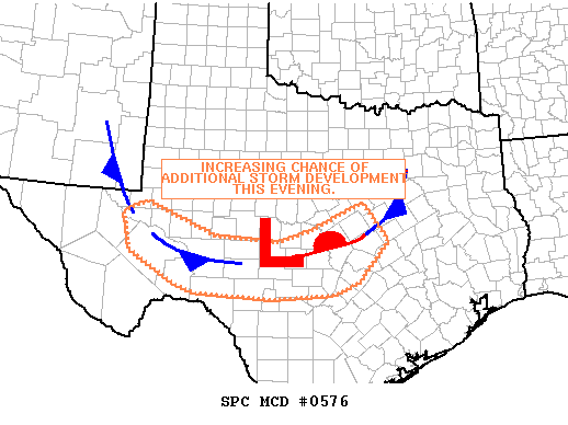
MESOSCALE DISCUSSION 0576
NWS STORM PREDICTION CENTER NORMAN OK
0521 PM CDT SAT MAY 15 2010
AREAS AFFECTED...TX
CONCERNING...SEVERE POTENTIAL...WATCH POSSIBLE
VALID 152221Z - 152345Z
ISOLATED SUPERCELL MOVG OVER HEMPSTEAD AND MCCULLOUGH COUNTIES AT
2215Z. THIS STORM APPEARS TO BE PERSISTING NEAR RESIDUAL
OUTFLOW/FRONT/INVERTED TROUGH INTERSECTION WHERE MESO-STORM-SCALE
FORCING AND SHEAR ARE CERTAINLY ADEQUATE TO MAINTAIN SUPERCELL
STRUCTURE.
AREA WIND PROFILES DEPICT RELATIVELY WEAK LOW LEVEL ELY/SLY FLOW AOB
10 KNOTS RESULTING IN AMBIENT SFC-1KM SRH ON THE ORDER OF 100 M2/S2
OR LESS. IT IS POSSIBLE THAT SHEAR NEAR THE BOUNDARY INTERSECTION
IS LOCALLY GREATER. SATELLITE IMAGERY REVEALS CORRIDOR OF STRONG
HEATING AHEAD OF THIS CELL AND IT IS QUITE POSSIBLE THAT RESULTANT
INSTABILITY/FORCING WILL MAINTAIN THE CHANCE FOR LARGE HAIL/HIGH
WIND AS THIS STORM DEVELOPS ESEWD OVER THE NEXT FEW HOURS.
MEANWHILE...DESTABILIZATION AND CAP EROSION ARE UNDERWAY ALONG AND
SOUTH OF THE OUTFLOW ZONE IN THE WAKE OF THIS STORM...AND WITHIN
INVERTED TROUGH AXIS AHEAD OF THE ONGOING CONVECTION. WV IMAGERY AND
OBJECTIVE DATA SUGGEST A WEAK SHORT WAVE TROUGH/SPEED MAX MOVING
EAST FROM FAR WEST TX/SERN NM. GIVEN ENHANCED LARGE SCALE ASCENT AND
MAGNITUDE OF INSTABILITY DEVELOPING ACROSS THE REGION...ADDITIONAL
CONVECTIVE DEVELOPMENT APPEARS POSSIBLE OVER THE NEXT SEVERAL HOURS.
IT IS THIS DEVELOPMENT...IF IT BEGINS TO OCCUR...THAT MAY PROMPT THE
ISSUANCE OF A WATCH ACROSS PARTS THE REGION.
..CARBIN.. 05/15/2010
ATTN...WFO...FWD...EWX...SJT...MAF...
-
sleetstorm
- Posts: 651
- Joined: Thu Feb 04, 2010 12:33 pm
- Contact:
I am hearing thunder outside again here in Baytown.
-
djjordan

- Posts: 929
- Joined: Fri Feb 05, 2010 7:19 pm
- Location: Montgomery, Texas
- Contact:
Will be interesting to see how this plays out .... looks like some interaction going with a leftover boundary causing these storms to flare up over Galveston Bay and Baytown areas.
~~~When Thunder Roars Go Indoors~~~
~~~Turn Around Don't Drown~~~
~~~Run From The Water, Hide From The Wind~~~
~~~Turn Around Don't Drown~~~
~~~Run From The Water, Hide From The Wind~~~
-
ticka1
- Posts: 1265
- Joined: Wed Feb 03, 2010 3:02 pm
- Location: Baytown/Mont Belvieu
- Contact:
Looks like the storms in west/central Texas are dying out this evening....
Maybe we won't see another deluge tomorrow.
Maybe we won't see another deluge tomorrow.
-
wxdata

- Site Admin

- Posts: 1059
- Joined: Wed Feb 03, 2010 3:04 pm
- Location: Houston, TX
- Contact:
Surprise development of storms approaching eastern Harris.sleetstorm wrote:I am hearing thunder outside again here in Baytown.
-
Ptarmigan
- Statistical Specialist
- Posts: 4519
- Joined: Wed Feb 03, 2010 7:20 pm
- Contact:
Should be worth following. I see the sky and Sun setting. The atmosphere I think has been destabilized again. The storms in West Texas are gone, but I expect another flare up later tonight. I remember in late April of 2009, it rained, than stopped, and a much harder rain that led to flooding.wxdata wrote:Surprise development of storms approaching eastern Harris.sleetstorm wrote:I am hearing thunder outside again here in Baytown.
-
Ptarmigan
- Statistical Specialist
- Posts: 4519
- Joined: Wed Feb 03, 2010 7:20 pm
- Contact:
This quietness has me a bit concerned for another storm. I hope I am wrong.
-
txflagwaver

- Posts: 411
- Joined: Wed Feb 03, 2010 2:37 pm
- Location: Seabrook/Kemah
- Contact:
So...are we done? More rain today or can we break out the barbie?? 
-
wxdata
- Site Admin
- Posts: 1059
- Joined: Wed Feb 03, 2010 3:04 pm
- Location: Houston, TX
- Contact:
Am agreeing with NWS assessment:
[Noon add] The MCS west of San Antonio may do the trick as well..
[2:30 add] Rain system near San Antonio losing steam a bit, only hope may be from a band of showers now along the I-35 corridor (or any kind of home-grown storms..)
What's missing is a really good 'trigger.' Maybe the weak front will do the trick...BUFR SOUNDINGS SHOW AN UNCAPPED ATMOSPHERE...CAPES AROUND 3000 J/KG AND LIS OF -6 TO
-8 AT 21Z. SEVERAL WEAK SFC BOUNDARIES ARE IN PLACE WHICH COULD FOCUS CONVECTIVE DEVELOPMENT. BOTH THE NAM AND 4KM NMM-WRF SHOW THE DIFFUSE FRONT NOW OVER NORTH TX PUSHING SOUTH INTO THE AREA
WITH CONVECTION FIRING ALONG THE BOUNDARY. HOWEVER...THEY DIFFER ON TIMING WITH NAM SHOWING DEVELOPMENT THIS AFTN AND THE WRF THIS EVENING.
[Noon add] The MCS west of San Antonio may do the trick as well..
[2:30 add] Rain system near San Antonio losing steam a bit, only hope may be from a band of showers now along the I-35 corridor (or any kind of home-grown storms..)
-
wxdata
- Site Admin
- Posts: 1059
- Joined: Wed Feb 03, 2010 3:04 pm
- Location: Houston, TX
- Contact:
A quickly developing storm southwest of Brenham.
-
wxdata
- Site Admin
- Posts: 1059
- Joined: Wed Feb 03, 2010 3:04 pm
- Location: Houston, TX
- Contact:
Another quickly developing thunderstorm near Columbus..
-
wxdata
- Site Admin
- Posts: 1059
- Joined: Wed Feb 03, 2010 3:04 pm
- Location: Houston, TX
- Contact:
SPECIAL WEATHER STATEMENT
NATIONAL WEATHER SERVICE HOUSTON/GALVESTON TX
420 PM CDT SUN MAY 16 2010
TXZ197-198-212-162215-
GRIMES-WALLER-WASHINGTON-
420 PM CDT SUN MAY 16 2010
...SIGNIFICANT WEATHER ADVISORY...
AT 417 PM CDT...NATIONAL WEATHER SERVICE DOPPLER RADAR INDICATED A
STRONG THUNDERSTORM 11 MILES NORTHWEST OF HEMPSTEAD...MOVING EAST AT
15 MPH.
ONE HALF INCH DIAMETER HAIL...WINDS GREATER THAN 40 MPH...FREQUENT
CLOUD TO GROUND LIGHTNING...BRIEF HEAVY DOWNPOURS...ARE POSSIBLE WITH
THIS STORM.
LOCATIONS IN THE PATH OF THIS STORM INCLUDE...PRAIRIE VIEW AND
HEMPSTEAD.
-
djjordan
- Posts: 929
- Joined: Fri Feb 05, 2010 7:19 pm
- Location: Montgomery, Texas
- Contact:
Interesting to watch these storms develop .... seeing a boundary on radar moving NW in Brazoria/Galveston counties .... will have to watch and see how this interacts with developing storms out west.
~~~When Thunder Roars Go Indoors~~~
~~~Turn Around Don't Drown~~~
~~~Run From The Water, Hide From The Wind~~~
~~~Turn Around Don't Drown~~~
~~~Run From The Water, Hide From The Wind~~~
-
wxdata
- Site Admin
- Posts: 1059
- Joined: Wed Feb 03, 2010 3:04 pm
- Location: Houston, TX
- Contact:
Gotta be a seabreeze!djjordan wrote:Interesting to watch these storms develop .... seeing a boundary on radar moving NW in Brazoria/Galveston counties .... will have to watch and see how this interacts with developing storms out west.
-
sleetstorm
- Posts: 651
- Joined: Thu Feb 04, 2010 12:33 pm
- Contact:
Thunderstorms developing in central Texas west of Waco and southern Texas as well.
-
wxdata
- Site Admin
- Posts: 1059
- Joined: Wed Feb 03, 2010 3:04 pm
- Location: Houston, TX
- Contact:
Unless we get a few 'boundary collisions,' this area may be done for rain this evening...
-
kayci

- Posts: 358
- Joined: Thu Feb 04, 2010 10:30 am
- Location: Alvin
- Contact:
Spent the weekend in Onalaska, TX/Livingston to fix mom & dad's A/C... came home to find my big oak tree down in my front yard (Texas city). What happened Saturday???? Left at 8 a.m. Saturday morning and it was just drizzling... came back today (Sunday) and my Oak tree was down. Neighbor said we only had light rains but a little wind. pooooor oak tree. breaking out the chainsaw. 