
April Weather Discussion.
-
wxdata

- Site Admin

- Posts: 1059
- Joined: Wed Feb 03, 2010 3:04 pm
- Location: Houston, TX
- Contact:
Interesting forecast from the ECMWF for next Monday. Snow skiing continues in the Southern Rockies?
-
wxdata
- Site Admin
- Posts: 1059
- Joined: Wed Feb 03, 2010 3:04 pm
- Location: Houston, TX
- Contact:
The eastern ridge continues to keep the heaviest rain west of here the next five days
-
srainhoutx

- Site Admin
- Posts: 19700
- Joined: Tue Feb 02, 2010 2:32 pm
- Location: Maggie Valley, NC
- Contact:
HGX thoughts this evening. Persky Western trough and SE Ridge seem to be cuasing some questions...
AREA FORECAST DISCUSSION...UPDATED FOR AVIATION
NATIONAL WEATHER SERVICE HOUSTON/GALVESTON TX
635 PM CDT SUN APR 11 2010
.DISCUSSION...
KIND OF A TRICKY FCST THIS GO AROUND AS MODELS CONTINUE TO WAFFLE
AND SE TX REMAINS ON THE PERIPHERY OF THE ACTION. SO FAR TODAY NO
SURPRISES COMING IN FROM THE WEST AS THE BULK OF THE ACTION CONT-
INUES TO DEVELOP IN/AROUND DRY LINE/PLUME OF DEEPER MOISTURE. THE
RIDGE SEEMS TO BE WINNING OUT HERE. FOR NOW WILL LIKELY KEEP WITH
THE DRIER FCST BUT CONTINUE TO HEDGE WITH SOME LOWISH POPS ACROSS
THE FAR W/SWRN COUNTIES THE NEXT COUPLE OF DAYS. THEREAFTER...12Z
RUNS LOOKING MUCH DRIER WITH THE MIDDLE/END OF THE WEEK FCST. THE
STRONG UPPER LOW THAT WAS INITIALLY PROGGED TO MOVE THRU WEDS/THU
IS NOW FCST TO BE MUCH WEAKER AS THE RIDGING ALOFT AMPLIFIES SOME
MORE AND EDGES WWD A TAD. HESITANT TO DROP POPS SIGNIFICANTLY FOR
THIS TIME FRAME ATTM AS THIS MIGHT BE THE ANOMALOUS RUN. BUT THIS
PATTERN DOES CONTINUE TO BODE POORLY FOR COASTAL LOCATIONS AS THE
DEEP/PERSISTENT EASTERLY FETCH HELPS TO PRODUCE LARGE SWELLS/ELE-
VATED TIDE LEVELS STARTING MON. 41
The big picture via Water Vapor Imagery...
http://wxweb.meteostar.com/models/noaap ... UMBLOOP=10
Carla/Alicia/Jerry(In The Eye)/Michelle/Charley/Ivan/Dennis/Katrina/Rita/Wilma/Humberto/Ike/Harvey
Member: National Weather Association
Facebook.com/Weather Infinity
Twitter @WeatherInfinity
Member: National Weather Association
Facebook.com/Weather Infinity
Twitter @WeatherInfinity
-
srainhoutx
- Site Admin
- Posts: 19700
- Joined: Tue Feb 02, 2010 2:32 pm
- Location: Maggie Valley, NC
- Contact:
Knowing that a lot of folks are participating in the MS 150, it appears that SE winds will provide a bit of a tail wind for the riders this year at this time. There also may be a chance of some showers as folks near Austin on Sunday according to the GFS. We shall see.
Carla/Alicia/Jerry(In The Eye)/Michelle/Charley/Ivan/Dennis/Katrina/Rita/Wilma/Humberto/Ike/Harvey
Member: National Weather Association
Facebook.com/Weather Infinity
Twitter @WeatherInfinity
Member: National Weather Association
Facebook.com/Weather Infinity
Twitter @WeatherInfinity
-
sleetstorm
- Posts: 651
- Joined: Thu Feb 04, 2010 12:33 pm
- Contact:
No more life giving, plant body lubricating, and thirst quenching rain for over a week is what the 12Z GFS shows, right, Ed?Ed Mahmoud wrote:12Z GFS- Sahara dry next 180 hours.
NAM next 3 days- sharp gradient between have and have nots in Texas near I-35.
-
srainhoutx
- Site Admin
- Posts: 19700
- Joined: Tue Feb 02, 2010 2:32 pm
- Location: Maggie Valley, NC
- Contact:
After being a bit burned last Saturday, HGX thinking rain chances will increase by the weekend...
AREA FORECAST DISCUSSION
NATIONAL WEATHER SERVICE HOUSTON/GALVESTON TX
410 AM CDT TUE APR 13 2010
.DISCUSSION...
UPPER RIDGING OVER EASTERN HALF OF U.S....AXIS CENTERED OVER
MISSISSIPPI VALLEY...WITH LOWERING HEIGHTS FROM ROCKIES BACK
TOWARDS THE PAC NW. SURFACE REFLECTION OF LARGE SURFACE HIGH OVER
EASTERN CANADA WITH LOWEST PRESSURES EVOLVING OVER CENTRAL ROCKIES.
THE GENERAL SYNOPTIC PATTERN OVER THE NEXT FEW DAYS WILL BE OF
THIS SURFACE HIGH SLIDING DOWN THE EAST COAST AND SETTLING OVER
THE SOUTHEASTERN U.S. THROUGH WEEK`S CLOSE. FOR US...THIS SIMPLY
TRANSLATES TO NEAR CUT-AND-PASTE DAILY MAX/MIN TEMPERATURES THAT
CLOSELY MIRROR MID-APRIL CLIMATE STANDARDS...A PERSISTENT EASTERLY
WIND...AND INCREASING RAIN CHANCES.
THE STRENGTH (OR WEAKNESS) OF THE SE U.S.-CENTERED HIGH`S
SOUTHWESTERN PERIPHERY WILL BE THE TRUE INDICATOR OF WHETHER WE
RECEIVE MID TO LATE WEEK PRECIPITATION. EXPERIENCE HAS THE
FORECAST LEANING TOWARDS HIGHER RAIN/STORM CHANCES FROM WEDNESDAY
THROUGH THE WEEKEND. TYPICALLY WITHIN THESE MACROSCALE SET-UPS
(BREAK DOWN OF UPPER EASTERN RIDGING WITH LOWERING DESERT SW
HEIGHTS/SOUTHEASTERN U.S.-BASED SURFACE HIGH) EASTERN TEXAS FALLS
WITHIN THAT WEAKNESS CORRIDOR WHERE ANY NORTHERN MEXICO (OR
WESTERN-TRAVELING GULF) VORT CAN COME UP AND AROUND A (SW`ERN)
WEAKENING OF AN EASTERN SFC HIGH. PWATS ARE MODELED TO INCREASE
FROM CURRENT 0.7-0.8" TO NEAR 1.4" THROUGH FRIDAY AS MORE MOISTURE-
RICH SOUTHERN GULF AIR CREEPS UP THE COASTAL BEND. CONVECTIVE
TEMPS IN THE UPPER 70S WILL BE MET DESPITE INCREASED MID-HIGH
CLOUDINESS BROUGHT ON FROM WESTERN CI (BLOW OFF FROM DRY LINE
CONVECTION OR SOUTHERN TX ACTIVITY). BOOKMARKED 20-30 POPS WILL
MOST LIKELY GO UP AS THIS INCREASINGLY UNSTABLE PATTERN PLAYS
ITSELF OUT THROUGH THE WORK WEEK. FWIW...HIGHER MOS POPS ARE TIMED
FOR THIS WEEKEND INTO EARLY NEXT WEEK. HAVE THE FEELING THAT OUR
WESTERN CWA WILL EXPERIENCE -TSRA FROM MID-WEEK ONWARD. WITH TEXAS
BEING IN THAT TRANSITORY ZONE BETWEEN WESTERN TROFFING AND EASTERN
RIDGING...AND NUMEROUS VORTS RIDING IN ON UPPER WESTERLIES (THINK
LAST SATURDAY MORNING)...-SHRA/ISO THUNDER WILL SOON SPREAD BACK
IN OVER SE TX. 31
SPC 2 Day Outlook...
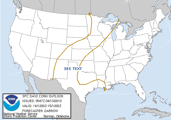
DAY 2 CONVECTIVE OUTLOOK
NWS STORM PREDICTION CENTER NORMAN OK
1247 AM CDT TUE APR 13 2010
VALID 141200Z - 151200Z
...NO SVR TSTM AREAS FORECAST...
...WEST TX TO THE CNTRL PLAINS...
THUNDERSTORM PROBABILITIES WILL CONTINUE TO BE MAXIMIZED ACROSS THE
SRN HIGH PLAINS...NEWD INTO THE MID/UPPER MS VALLEY...PRIMARILY
ALONG WRN PERIPHERY OF DOMINANT ANTICYCLONE CENTERED OVER THE GULF
STATES. THE AFOREMENTIONED AXIS WILL CONTINUE TO SUPPORT DEEP
CONVECTION PRIMARILY DUE TO PERSISTENT DEEP ELY TRAJECTORIES ACROSS
THE GOM FORCING MOISTURE UP THE RIO GRANDE VALLEY INTO NM...BEFORE
BEING TRANSPORTED DOWNSTREAM INTO IA AHEAD OF WEAK FRONTAL BOUNDARY.
MODEL FORECAST SOUNDINGS SUGGEST SUBSTANTIAL CLOUDINESS WILL EXIST
WITHIN THIS MOIST PLUME...MUCH OF IT CONVECTIVE DEBRIS FROM EARLIER
DAY1 ACTIVITY. IN THE ABSENCE OF SIGNIFICANT CAPPING...DIURNAL
HEATING AND TOPOGRAPHICAL FORCING WILL CERTAINLY AID RENEWED
THUNDERSTORM DEVELOPMENT...ESPECIALLY ACROSS FAR WEST TX AND NM
AHEAD OF WEAK SHORTWAVE TROUGH. FORECAST SHEAR IS EXPECTED TO BE
MODEST AT BEST...SFC-6KM OF 15-25KT...THOUGH VEERING WITH HEIGHT
WOULD SEEM TO SUPPORT THE POSSIBILITY FOR WEAK ROTATION AND PERHAPS
A FEW SUPERCELL-LIKE STRUCTURES. WITH LLJ EXPECTED TO INCREASE
DURING THE EVENING ACROSS W TX INTO KS ANY STORMS THAT DEVELOP
ACROSS THE HIGH PLAINS MAY LINGER DEEP INTO THE OVERNIGHT HOURS AS
THEY PROPAGATE/DEVELOP SLOWLY EWD. BOTH THE GFS AND NAM SUGGEST AN
MCS COULD EMERGE ACROSS ERN NM/W TX DURING THE LATTER HALF OF THE
PERIOD AS LOW LEVEL INFLOW...PARTLY AIDED BY DIURNAL
PROCESSES...INCREASES INTO DEVELOPING CONVECTION. HAIL WILL BE THE
PRIMARY THREAT WITH THIS ACTIVITY.
..DARROW.. 04/13/2010
AREA FORECAST DISCUSSION
NATIONAL WEATHER SERVICE HOUSTON/GALVESTON TX
410 AM CDT TUE APR 13 2010
.DISCUSSION...
UPPER RIDGING OVER EASTERN HALF OF U.S....AXIS CENTERED OVER
MISSISSIPPI VALLEY...WITH LOWERING HEIGHTS FROM ROCKIES BACK
TOWARDS THE PAC NW. SURFACE REFLECTION OF LARGE SURFACE HIGH OVER
EASTERN CANADA WITH LOWEST PRESSURES EVOLVING OVER CENTRAL ROCKIES.
THE GENERAL SYNOPTIC PATTERN OVER THE NEXT FEW DAYS WILL BE OF
THIS SURFACE HIGH SLIDING DOWN THE EAST COAST AND SETTLING OVER
THE SOUTHEASTERN U.S. THROUGH WEEK`S CLOSE. FOR US...THIS SIMPLY
TRANSLATES TO NEAR CUT-AND-PASTE DAILY MAX/MIN TEMPERATURES THAT
CLOSELY MIRROR MID-APRIL CLIMATE STANDARDS...A PERSISTENT EASTERLY
WIND...AND INCREASING RAIN CHANCES.
THE STRENGTH (OR WEAKNESS) OF THE SE U.S.-CENTERED HIGH`S
SOUTHWESTERN PERIPHERY WILL BE THE TRUE INDICATOR OF WHETHER WE
RECEIVE MID TO LATE WEEK PRECIPITATION. EXPERIENCE HAS THE
FORECAST LEANING TOWARDS HIGHER RAIN/STORM CHANCES FROM WEDNESDAY
THROUGH THE WEEKEND. TYPICALLY WITHIN THESE MACROSCALE SET-UPS
(BREAK DOWN OF UPPER EASTERN RIDGING WITH LOWERING DESERT SW
HEIGHTS/SOUTHEASTERN U.S.-BASED SURFACE HIGH) EASTERN TEXAS FALLS
WITHIN THAT WEAKNESS CORRIDOR WHERE ANY NORTHERN MEXICO (OR
WESTERN-TRAVELING GULF) VORT CAN COME UP AND AROUND A (SW`ERN)
WEAKENING OF AN EASTERN SFC HIGH. PWATS ARE MODELED TO INCREASE
FROM CURRENT 0.7-0.8" TO NEAR 1.4" THROUGH FRIDAY AS MORE MOISTURE-
RICH SOUTHERN GULF AIR CREEPS UP THE COASTAL BEND. CONVECTIVE
TEMPS IN THE UPPER 70S WILL BE MET DESPITE INCREASED MID-HIGH
CLOUDINESS BROUGHT ON FROM WESTERN CI (BLOW OFF FROM DRY LINE
CONVECTION OR SOUTHERN TX ACTIVITY). BOOKMARKED 20-30 POPS WILL
MOST LIKELY GO UP AS THIS INCREASINGLY UNSTABLE PATTERN PLAYS
ITSELF OUT THROUGH THE WORK WEEK. FWIW...HIGHER MOS POPS ARE TIMED
FOR THIS WEEKEND INTO EARLY NEXT WEEK. HAVE THE FEELING THAT OUR
WESTERN CWA WILL EXPERIENCE -TSRA FROM MID-WEEK ONWARD. WITH TEXAS
BEING IN THAT TRANSITORY ZONE BETWEEN WESTERN TROFFING AND EASTERN
RIDGING...AND NUMEROUS VORTS RIDING IN ON UPPER WESTERLIES (THINK
LAST SATURDAY MORNING)...-SHRA/ISO THUNDER WILL SOON SPREAD BACK
IN OVER SE TX. 31
SPC 2 Day Outlook...
DAY 2 CONVECTIVE OUTLOOK
NWS STORM PREDICTION CENTER NORMAN OK
1247 AM CDT TUE APR 13 2010
VALID 141200Z - 151200Z
...NO SVR TSTM AREAS FORECAST...
...WEST TX TO THE CNTRL PLAINS...
THUNDERSTORM PROBABILITIES WILL CONTINUE TO BE MAXIMIZED ACROSS THE
SRN HIGH PLAINS...NEWD INTO THE MID/UPPER MS VALLEY...PRIMARILY
ALONG WRN PERIPHERY OF DOMINANT ANTICYCLONE CENTERED OVER THE GULF
STATES. THE AFOREMENTIONED AXIS WILL CONTINUE TO SUPPORT DEEP
CONVECTION PRIMARILY DUE TO PERSISTENT DEEP ELY TRAJECTORIES ACROSS
THE GOM FORCING MOISTURE UP THE RIO GRANDE VALLEY INTO NM...BEFORE
BEING TRANSPORTED DOWNSTREAM INTO IA AHEAD OF WEAK FRONTAL BOUNDARY.
MODEL FORECAST SOUNDINGS SUGGEST SUBSTANTIAL CLOUDINESS WILL EXIST
WITHIN THIS MOIST PLUME...MUCH OF IT CONVECTIVE DEBRIS FROM EARLIER
DAY1 ACTIVITY. IN THE ABSENCE OF SIGNIFICANT CAPPING...DIURNAL
HEATING AND TOPOGRAPHICAL FORCING WILL CERTAINLY AID RENEWED
THUNDERSTORM DEVELOPMENT...ESPECIALLY ACROSS FAR WEST TX AND NM
AHEAD OF WEAK SHORTWAVE TROUGH. FORECAST SHEAR IS EXPECTED TO BE
MODEST AT BEST...SFC-6KM OF 15-25KT...THOUGH VEERING WITH HEIGHT
WOULD SEEM TO SUPPORT THE POSSIBILITY FOR WEAK ROTATION AND PERHAPS
A FEW SUPERCELL-LIKE STRUCTURES. WITH LLJ EXPECTED TO INCREASE
DURING THE EVENING ACROSS W TX INTO KS ANY STORMS THAT DEVELOP
ACROSS THE HIGH PLAINS MAY LINGER DEEP INTO THE OVERNIGHT HOURS AS
THEY PROPAGATE/DEVELOP SLOWLY EWD. BOTH THE GFS AND NAM SUGGEST AN
MCS COULD EMERGE ACROSS ERN NM/W TX DURING THE LATTER HALF OF THE
PERIOD AS LOW LEVEL INFLOW...PARTLY AIDED BY DIURNAL
PROCESSES...INCREASES INTO DEVELOPING CONVECTION. HAIL WILL BE THE
PRIMARY THREAT WITH THIS ACTIVITY.
..DARROW.. 04/13/2010
Carla/Alicia/Jerry(In The Eye)/Michelle/Charley/Ivan/Dennis/Katrina/Rita/Wilma/Humberto/Ike/Harvey
Member: National Weather Association
Facebook.com/Weather Infinity
Twitter @WeatherInfinity
Member: National Weather Association
Facebook.com/Weather Infinity
Twitter @WeatherInfinity
-
wxdata
- Site Admin
- Posts: 1059
- Joined: Wed Feb 03, 2010 3:04 pm
- Location: Houston, TX
- Contact:
UKMET agrees with ECMWF. Hard to see, but that model has a cut-off low over central Texas.
-
wxdata
- Site Admin
- Posts: 1059
- Joined: Wed Feb 03, 2010 3:04 pm
- Location: Houston, TX
- Contact:
HPC- some rain for Houston over the weekend, however heavier rains stay west
-
srainhoutx
- Site Admin
- Posts: 19700
- Joined: Tue Feb 02, 2010 2:32 pm
- Location: Maggie Valley, NC
- Contact:
The ECMWF remains rather insistent that an Upper Low will traverse the area over the weekend. Timing appears to be an issue and any Meso Low activity could make for an interesting ride for those heading toward Austin in the MS 150.
Carla/Alicia/Jerry(In The Eye)/Michelle/Charley/Ivan/Dennis/Katrina/Rita/Wilma/Humberto/Ike/Harvey
Member: National Weather Association
Facebook.com/Weather Infinity
Twitter @WeatherInfinity
Member: National Weather Association
Facebook.com/Weather Infinity
Twitter @WeatherInfinity
-
wxdata
- Site Admin
- Posts: 1059
- Joined: Wed Feb 03, 2010 3:04 pm
- Location: Houston, TX
- Contact:
HPC's forecast maps drags a low across Texas toward the central Texas Gulf coast Sunday. The maps suggests that most of SE TX could be in the warm sector before the cold front crosses the area. If valid, it sure does raise at least a small flag on Sunday's weather...
-
wxdata
- Site Admin
- Posts: 1059
- Joined: Wed Feb 03, 2010 3:04 pm
- Location: Houston, TX
- Contact:
If you've thought this severe weather season has been slow, you're right. Here's some fascinating stats from Accuweather meteorologist Jesse Ferrel:
http://www.accuweather.com/blogs/weathe ... saries.asp
http://www.accuweather.com/blogs/weathe ... saries.asp
-
srainhoutx
- Site Admin
- Posts: 19700
- Joined: Tue Feb 02, 2010 2:32 pm
- Location: Maggie Valley, NC
- Contact:
A bit of a tough forecast for those participating in the MS 150 this weekend. It appears that guidance may be over doing the rain at this time (convective feedback issues) as the riders make their stop in La Grange Saturday afternoon. NWS Austin/San Antonio is mentioning this as well as light N/NW winds for Saturday and Sunday. Perhaps the next couple of days will iron out the timing issue of the Upper Low and attending cool frontal boundary.
Carla/Alicia/Jerry(In The Eye)/Michelle/Charley/Ivan/Dennis/Katrina/Rita/Wilma/Humberto/Ike/Harvey
Member: National Weather Association
Facebook.com/Weather Infinity
Twitter @WeatherInfinity
Member: National Weather Association
Facebook.com/Weather Infinity
Twitter @WeatherInfinity
-
srainhoutx
- Site Admin
- Posts: 19700
- Joined: Tue Feb 02, 2010 2:32 pm
- Location: Maggie Valley, NC
- Contact:
Morning e-mail from Jeff...
Increasing rain chances along with some heavy rainfall becoming increasingly likely late this week into this weekend.
Gulf moisture is starting to increase over the region as noted by low to mid 60 degree dewpoints versus the lower 50 degree dewpoints yesterday. Additionally, the radar shows scattered showers off the coast of Matagorda Bay this morning indicating the leading edge of deeper moisture plume which has been over S TX the last few days. Highly unusual blocking pattern for mid April (more like July without the heat) will slowly break down over the next 72-96 hours allowing deep moisture in 12,000 ft deep easterly flow to advect NE over SE TX starting Thursday and peaking this weekend. Upper ridge over the SE US will break down on the western side allowing our area to become vulnerable to incoming short waves out of NE Mexico.
Will go with highest rain chances today and Thursday from Matagorda Bay to Austin and SW of that line where deepest moisture will be located, and then pull rain chances across the entire region Friday-Sunday as deep moisture pool moves overhead along with good dynamics aloft and upper air divergence. Models are hinting at a fairly robust short wave moving out of Mexico late Friday into early Saturday into a very favorable low level environment for heavy to excessive rainfall. If the models verify, expect the formation of a large MCS capable for some very heavy rains over S TX into the coastal bend and the W/SW portions of SE TX. Models are even hinting at surface low formation in the W/NW Gulf with this feature and would not be surprised to see either a main surface low form or meso low formation within the convective complex Saturday morning.
Heavy Rains
For now will keep the heaviest rains pegged from Rockport to Victoria to Austin eastward to Columbus and Bay City Friday-Saturday where HPC guidance is showing Day 4/5 totals of 2-3 inches. Extended period of moderate to at times heavy rainfall in a nearly saturated air mass with PWS of 1.5 inches or greater does raise some flooding concerns even with dry grounds. While SE to NW moving streamers out of the Gulf could produce a quick 1-2 inches Thursday, the main event looks late Friday into late Saturday when the strong S TX vort moves toward the region. A highly meso scale environment could promote deep convection near the coast or offshore keeping eh excessive rainfall over the NW Gulf…will have to watch and wait to see how things unfold in such an environment. Models are still not in good agreement with events post Saturday evening as ECMWF cuts off the short wave into an upper low over S TX pumping tremendous moisture into SE TX while the GFS continues to keep a progressive pattern allowing drying. Think the details in the meso scale events on Saturday may end up being right as a large convective complex may scour the region of deep quality moisture.
As has been the case the past few days…changes to the forecast are likely…probably toward a wetter solution with higher rain chances. Will need to keep a close watch on the flood potential especially around Matagorda Bay.
Carla/Alicia/Jerry(In The Eye)/Michelle/Charley/Ivan/Dennis/Katrina/Rita/Wilma/Humberto/Ike/Harvey
Member: National Weather Association
Facebook.com/Weather Infinity
Twitter @WeatherInfinity
Member: National Weather Association
Facebook.com/Weather Infinity
Twitter @WeatherInfinity
-
wxdata
- Site Admin
- Posts: 1059
- Joined: Wed Feb 03, 2010 3:04 pm
- Location: Houston, TX
- Contact:
12z NGM coming in decidedly wetter than yesterday.
-
sleetstorm
- Posts: 651
- Joined: Thu Feb 04, 2010 12:33 pm
- Contact:
As long as what showers and thunderstorms do form do not move slowly over the same areas if some of them do train. Yes, we do need rain but not all at one time.
-
biggerbyte
- Posts: 1437
- Joined: Thu Feb 04, 2010 12:15 am
- Location: Porter, Texas. (Montgomery County)
- Contact:
srainhoutx wrote:Morning e-mail from Jeff...
Increasing rain chances along with some heavy rainfall becoming increasingly likely late this week into this weekend.
Gulf moisture is starting to increase over the region as noted by low to mid 60 degree dewpoints versus the lower 50 degree dewpoints yesterday. Additionally, the radar shows scattered showers off the coast of Matagorda Bay this morning indicating the leading edge of deeper moisture plume which has been over S TX the last few days. Highly unusual blocking pattern for mid April (more like July without the heat) will slowly break down over the next 72-96 hours allowing deep moisture in 12,000 ft deep easterly flow to advect NE over SE TX starting Thursday and peaking this weekend. Upper ridge over the SE US will break down on the western side allowing our area to become vulnerable to incoming short waves out of NE Mexico.
Will go with highest rain chances today and Thursday from Matagorda Bay to Austin and SW of that line where deepest moisture will be located, and then pull rain chances across the entire region Friday-Sunday as deep moisture pool moves overhead along with good dynamics aloft and upper air divergence. Models are hinting at a fairly robust short wave moving out of Mexico late Friday into early Saturday into a very favorable low level environment for heavy to excessive rainfall. If the models verify, expect the formation of a large MCS capable for some very heavy rains over S TX into the coastal bend and the W/SW portions of SE TX. Models are even hinting at surface low formation in the W/NW Gulf with this feature and would not be surprised to see either a main surface low form or meso low formation within the convective complex Saturday morning.
Heavy Rains
For now will keep the heaviest rains pegged from Rockport to Victoria to Austin eastward to Columbus and Bay City Friday-Saturday where HPC guidance is showing Day 4/5 totals of 2-3 inches. Extended period of moderate to at times heavy rainfall in a nearly saturated air mass with PWS of 1.5 inches or greater does raise some flooding concerns even with dry grounds. While SE to NW moving streamers out of the Gulf could produce a quick 1-2 inches Thursday, the main event looks late Friday into late Saturday when the strong S TX vort moves toward the region. A highly meso scale environment could promote deep convection near the coast or offshore keeping eh excessive rainfall over the NW Gulf…will have to watch and wait to see how things unfold in such an environment. Models are still not in good agreement with events post Saturday evening as ECMWF cuts off the short wave into an upper low over S TX pumping tremendous moisture into SE TX while the GFS continues to keep a progressive pattern allowing drying. Think the details in the meso scale events on Saturday may end up being right as a large convective complex may scour the region of deep quality moisture.
As has been the case the past few days…changes to the forecast are likely…probably toward a wetter solution with higher rain chances. Will need to keep a close watch on the flood potential especially around Matagorda Bay.
Jeff is right on with this. Look out for the weekend, folks, if you are wanting/needing rain. This time around, instead of north and west, it looks to be south and west with the heaviest rainfall. However, the immediate Houston area will get some decent coverage for a change. Montgomery county is fine either way, as it stands right now, just so we don't get it all at once. We are saturated just below the surface. The top layer in my lawn just dried a little starting today.
-
sleetstorm
- Posts: 651
- Joined: Thu Feb 04, 2010 12:33 pm
- Contact:
Does it look as though we may get some rather hefty rain off and on, biggerbyte?biggerbyte wrote:srainhoutx wrote:Morning e-mail from Jeff...
Increasing rain chances along with some heavy rainfall becoming increasingly likely late this week into this weekend.
Gulf moisture is starting to increase over the region as noted by low to mid 60 degree dewpoints versus the lower 50 degree dewpoints yesterday. Additionally, the radar shows scattered showers off the coast of Matagorda Bay this morning indicating the leading edge of deeper moisture plume which has been over S TX the last few days. Highly unusual blocking pattern for mid April (more like July without the heat) will slowly break down over the next 72-96 hours allowing deep moisture in 12,000 ft deep easterly flow to advect NE over SE TX starting Thursday and peaking this weekend. Upper ridge over the SE US will break down on the western side allowing our area to become vulnerable to incoming short waves out of NE Mexico.
Will go with highest rain chances today and Thursday from Matagorda Bay to Austin and SW of that line where deepest moisture will be located, and then pull rain chances across the entire region Friday-Sunday as deep moisture pool moves overhead along with good dynamics aloft and upper air divergence. Models are hinting at a fairly robust short wave moving out of Mexico late Friday into early Saturday into a very favorable low level environment for heavy to excessive rainfall. If the models verify, expect the formation of a large MCS capable for some very heavy rains over S TX into the coastal bend and the W/SW portions of SE TX. Models are even hinting at surface low formation in the W/NW Gulf with this feature and would not be surprised to see either a main surface low form or meso low formation within the convective complex Saturday morning.
Heavy Rains
For now will keep the heaviest rains pegged from Rockport to Victoria to Austin eastward to Columbus and Bay City Friday-Saturday where HPC guidance is showing Day 4/5 totals of 2-3 inches. Extended period of moderate to at times heavy rainfall in a nearly saturated air mass with PWS of 1.5 inches or greater does raise some flooding concerns even with dry grounds. While SE to NW moving streamers out of the Gulf could produce a quick 1-2 inches Thursday, the main event looks late Friday into late Saturday when the strong S TX vort moves toward the region. A highly meso scale environment could promote deep convection near the coast or offshore keeping eh excessive rainfall over the NW Gulf…will have to watch and wait to see how things unfold in such an environment. Models are still not in good agreement with events post Saturday evening as ECMWF cuts off the short wave into an upper low over S TX pumping tremendous moisture into SE TX while the GFS continues to keep a progressive pattern allowing drying. Think the details in the meso scale events on Saturday may end up being right as a large convective complex may scour the region of deep quality moisture.
As has been the case the past few days…changes to the forecast are likely…probably toward a wetter solution with higher rain chances. Will need to keep a close watch on the flood potential especially around Matagorda Bay.
Jeff is right on with this. Look out for the weekend, folks, if you are wanting/needing rain. This time around, instead of north and west, it looks to be south and west with the heaviest rainfall. However, the immediate Houston area will get some decent coverage for a change. Montgomery county is fine either way, as it stands right now, just so we don't get it all at once. We are saturated just below the surface. The top layer in my lawn just dried a little starting today.
-
Ptarmigan

- Statistical Specialist

- Posts: 4521
- Joined: Wed Feb 03, 2010 7:20 pm
- Contact:
Nice to see some rain for a change to clear the air of pollen. 
-
biggerbyte
- Posts: 1437
- Joined: Thu Feb 04, 2010 12:15 am
- Location: Porter, Texas. (Montgomery County)
- Contact:
Yes, it sure looks like we could. This is a change from the past few days. I would not expect the kind of rain potential we'll see west and south of the Houston area, but things look much better for many to get in
on some action.
on some action.
-
wxdata
- Site Admin
- Posts: 1059
- Joined: Wed Feb 03, 2010 3:04 pm
- Location: Houston, TX
- Contact:
HPC's 0z QPF is still not that bullish on rain here in the Houston metro area with half inch or lessbiggerbyte wrote:Yes, it sure looks like we could. This is a change from the past few days. I would not expect the kind of rain potential we'll see west and south of the Houston area, but things look much better for many to get in
on some action.