It's out to 120 hours. The last runs showed the -10 isotherm at 850 over Houston. If that continues, that indicates highs below freezing for us with lows well into the teens...we only have to wait another 15 min. or so for the 00z to finish.
The 00z euro continues to be our friend showing a significant snow event across most of central and east Texas. Houston is on the cusp and for this being so far out, I can tell you with certainty (talking with them now) that the NWS in Houston has taken notice. The Euro shows extreme cold for this time of year with highs below freezing for Houston with the possibility of snow. It is uncanny to have such run to run consistency with the Euro. I can tell you that if the 00z Euro comes to fruition, Houston is in for a snowstorm!
Talking with Mr. T and a guy from HGX, we all agree that this is just like the '08 event. It appears that the 00z euro shows the trough swinging through and into the Great Lakes region. While it does get cold here, most of it goes east. That's why the 00z is a bit warmer this run. HOWEVER, the cold to produce the snow would be produced by the low as it passes directly overhead. The 00z couldn't be a better gift to the Houston area...assuming it comes to fruition. This run would bring snow from Houston to Pensacola!
I was told by my source at hgx that the euro shows 2" of qpf for San Angelo...ALL SNOW. What that means for us? Well, time will tell. For those of you who are not weather savvy, assuming your ratio is 10 to 1, that means San Angelo could get 20 inches of snow...if this model is correct!
Candy Cane wrote:The 00z euro continues to be our friend showing a significant snow event across most of central and east Texas. Houston is on the cusp and for this being so far out, I can tell you with certainty (talking with them now) that the NWS in Houston has taken notice. The Euro shows extreme cold for this time of year with highs below freezing for Houston with the possibility of snow. It is uncanny to have such run to run consistency with the Euro. I can tell you that if the 00z Euro comes to fruition, Houston is in for a snowstorm!
Talking with Mr. T and a guy from HGX, we all agree that this is just like the '08 event. It appears that the 00z euro shows the trough swinging through and into the Great Lakes region. While it does get cold here, most of it goes east. That's why the 00z is a bit warmer this run. HOWEVER, the cold to produce the snow would be produced by the low as it passes directly overhead. The 00z couldn't be a better gift to the Houston area...assuming it comes to fruition. This run would bring snow from Houston to Pensacola!
I was told by my source at hgx that the euro shows 2" of qpf for San Angelo...ALL SNOW. What that means for us? Well, time will tell. For those of you who are not weather savvy, assuming your ratio is 10 to 1, that means San Angelo could get 20 inches of snow...if this model is correct!
Well tonight's Euro definitely has me a bit excited now...
The 0z Euro is a perfect upper level pattern for us to produce snow. The question would be if it would be cold enough...
Edit: Yeah, talking it over, it looks like it would be a big snow producer for Central and North Texas (5 to 10 in.), while Houston would recieve snow but maybe only an inch or two. I'd take that!
Let the games begin. I will be even more excited once the gfs gets on board. Next week could be interesting. Alright time for bed.
Once I get more time tom I will try and write up an analysis of what I think. Good job Mr.T and Candy for the late night posts.
For Your Infinite Source For All Things Weather Visit Our Facebook
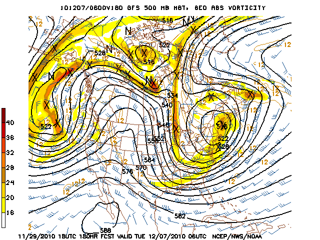
00z Euro at 192: This is the reason to be excited...the only thing to notice on this graphic is the top box. The placement of the low directly over Houston would bring in enough cold air to produce widespread snow from Houston northwards with HEAVY snowfall from central and east Texas up into Dallas. This run is a tad warmer than the 12z but it really doesn't matter. This run shows a well placed trough and a deep low. Heaviest snow would be north of Houston because it would be colder, faster up north and the most convergence or lift would be at or north for the low.
Candy Cane wrote:00z Euro at 192: This is the reason to be excited...the only thing to notice on this graphic is the top box. The placement of the low directly over Houston would bring in enough cold air to produce widespread snow from Houston northwards with HEAVY snowfall from central and east Texas up into Dallas. This run is a tad warmer than the 12z but it really doesn't matter. This run shows a well placed trough and a deep low. Heaviest snow would be north of Houston because it would be colder, faster up north and the most convergence or lift would be at or north for the low.
That would be snow right there! The real snow! Wow that looks awesome. I feel like tom morning we will have a lot of people active on here when they see that.
For Your Infinite Source For All Things Weather Visit Our Facebook
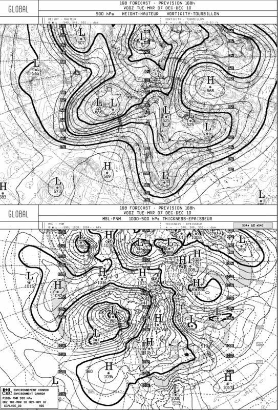
Good morning. I see the board was lively overnight. Just a word of caution and certainly not anything to dampen the activity, but we have seen the models offer a solution many times that leads to disappointment in the end results. We are talking about a possible event next Tuesday, a lifetime in model world. We have to remember that everything has to work just right to get a wintry event in our part of the world. That being said, forecaster Roth of the HPC offers a great discussion of the modeling issues involved and what he (the HPC) feels or expects is the most sensible solution at this range…
THE GLOBAL DETERMINISTIC AND ENSEMBLE GUIDANCE IS IN GOOD
AGREEMENT THAT A DEEP CYCLONE WILL BE SLOWLY PROGRESSING THROUGH
THE NORTHEAST PACIFIC...AND THAT A NEGATIVELY TILTED TROUGH WITH
AN EMBEDDED DEEP CYCLONE WILL LURK NEAR NEW ENGLAND AND ATLANTIC
CANADA THROUGH THE PERIOD /THE 00Z CANADIAN HAS ISSUES WITH THIS
LATTER SYSTEM DUE TO ITS UNIQUE SOLUTION IN CENTRAL CANADA EARLY
TO MID NEXT WEEK/.
THERE ARE PAIR OF FORECAST ISSUES EARLY THIS MORNING. THE FIRST
ISSUE REVOLVES AROUND A PACIFIC SHORTWAVE MOVING OVER THE TOP OF
THE BROAD/INCREASINGLY STRONG RIDGE CENTERED ACROSS THE SOUTHERN
STATES WHICH MOVES NEAR THE US/CANADIAN BORDER BEFORE DIVING
EAST-SOUTHEAST INTO THE MID-ATLANTIC STATES. THE 00Z CANADIAN/00Z
ECMWF MOVE THE SYSTEM THROUGH THE NORTH AND EAST ABOUT A DAY
QUICKER THAN THE 00Z GFS...AS THE GFS USES ADDITIONAL NORTHERN
STREAM ENERGY MOVING THROUGH WESTERN CANADA TO SLOW ITS PACE AS IT
MOVES THROUGH AN OTHERWISE QUICK QUASI-ZONAL/SUPERGEOSTROPHIC
FLOW. ALSO...BY THE TIME IS MOVES NEAR THE MID-ATLANTIC
STATES...THE GFS BRINGS 500 HPA HEIGHTS 4.5-5 STANDARD DEVIATIONS
BELOW NORMAL FOR THIS TIME OF THE YEAR BETWEEN CHARLESTON SC AND
JACKSONVILLE FL...WHICH IS IMPROBABLE. SINCE THE ECMWF ENSEMBLE
MEMBER TIMING HAS BEEN REASONABLY CONSISTENT OVER ITS PAST FEW
DAYS OF RUNS...AND INDICATE A QUICKER PROGRESSION...WILL CONTINUE
TO GO WITH THIS IDEA BY FAVORING A 00Z ECMWF-LIKE SOLUTION...WHICH
LOOKS MUCH MORE PLAUSIBLE THAN ITS PRIOR COUPLE DAYS OF RUNS.
THE SECOND ISSUE INVOLVES A POTENTIALLY CLOSED LOW MOVING THROUGH
THE SOUTHWEST...WHICH BOTH THE 00Z CANADIAN/00Z ECMWF ADVERTISE. THE 00Z GFS HAS A CLOSED LOW WHICH IT DEVELOPS MUCH FARTHER
OFFSHORE THE SOUTHERN CALIFORNIA COAST...WHICH TAKES AN EXTRA
COUPLE DAYS TO GET INTO THE SOUTHWEST. THE GFS SOLUTION IS SLOWER
THAN THE EITHER CLUSTER OF THE BIMODAL 00Z GEFS MEAN AND MUCH
SLOWER THAN THE 12Z ECMWF ENSEMBLE MEAN SOLUTION. A SLOWLY
PROGRESSIVE NORTHERN STREAM RIDGE IN SOUTHWEST CANADA FAVORS A
PROGRESSIVE CLOSED CYCLONE 20 DEGREES UNDER ITS BASE MOVING
THROUGH THE SOUTHWEST...SO CONFIDENCE IS HIGHER THAN NORMAL IN ITS
EXISTENCE...BUT TIMING IS AN ISSUE...AS IS USUALLY THE CASE LATE
IN THE MEDIUM RANGE PERIOD.SINCE THE CLOSED MEMBERS OF THE 12Z
GEFS MEAN /USING 5520 METER 500 HPA HEIGHT LINE SPAGHETTIS/ WERE
IN LINE WITH A BULK OF THE 12Z ECMWF ENSEMBLE MEMBERS...AND THE
NORTHERN STREAM RIDGE IS ONLY SLOWLY PROGRESSIVE...THINK A QUICKER
PROGRESSION OF THE CLOSED LOW IS ADVISABLE...WHICH IS BEST IN LINE
WITH THE 00Z CANADIAN SOLUTION. THIS FITS INTO THE 00Z GEFS
MEAN/00Z ECMWF COMPROMISE PREFERENCE QUITE WELL.
Carla/Alicia/Jerry(In The Eye)/Michelle/Charley/Ivan/Dennis/Katrina/Rita/Wilma/Humberto/Ike/Harvey
Member: National Weather Association
Facebook.com/Weather Infinity
Twitter @WeatherInfinity
Candy Cane wrote:00z Euro at 192: This is the reason to be excited...the only thing to notice on this graphic is the top box. The placement of the low directly over Houston would bring in enough cold air to produce widespread snow from Houston northwards with HEAVY snowfall from central and east Texas up into Dallas. This run is a tad warmer than the 12z but it really doesn't matter. This run shows a well placed trough and a deep low. Heaviest snow would be north of Houston because it would be colder, faster up north and the most convergence or lift would be at or north for the low.
That would be snow right there! The real snow! Wow that looks awesome. I feel like tom morning we will have a lot of people active on here when they see that.
I look at the graphic above and see cold air overhead but the precip is most likely east of us by the time it's cold enough for snow. Typically, when we get a coastal (west Gulf) low, the precip is heaviest when the low is to our west and it ends once the center of the low moves east of 95W (east of us). There are exceptions, though, like when an upper level low moves right overhead. That happened in 2008, I believe, when the upper low moved right across us and dropped 3-5 inches in some areas.
It's still too far out to get excited about anything. Quite a lot can change in 7 days. And the Euro is still the model outlier with the trof/upper low next week. GFS shows absolutely nothing. Canadian moves the front through right with the upper trof, with no post-frontal precip. Most likely, something between the GFS and Euro will occur, maybe closer to the Canadian solution.
Updated Prelim Discussion offers some interesting tidbits...there appears to be some 'hints' at a shift toward the Euro...
PRELIMINARY EXTENDED FORECAST DISCUSSION
NWS HYDROMETEOROLOGICAL PREDICTION CENTER CAMP SPRINGS MD
859 AM EST TUE NOV 30 2010
VALID 12Z SAT DEC 04 2010 - 12Z TUE DEC 07 2010
THERE IS GENERAL AGREEMENT WITH THE DETERMINISTIC AND ENS MODEL
GUIDANCE THAT A HIGHLY AMPLIFIED PATTERN WILL RULE THE MEDIUM RNG
PERIOD SPANNING FROM DEC 3...FRI THRU DEC 7...TUE. ON D3...LONGWV
RIDGING WILL COVER THE CENTER OF THE COUNTRY BEFORE BREAKING DOWN
AS STRONG HGT FALLS SPILL DOWN FROM CNTRL CANADA AND INTO THE
NORTH-CNTRL U.S. THIS ENERGY WILL EVENTUALLY MAKE ITS WAY INTO THE
NE U.S. WHERE IT WILL HELP FURTHER INVIGORATE AN EXPANSIVE UPR
VORTEX ACRS UPR NEW ENGLAND/SE CANADA. FARTHER TO THE WEST...A
SPLIT FLOW ACRS THE PACIFIC WILL FEATURE A STRONG DISTURBANCE
WITHIN THE SRN STREAM WHICH IS FCST TO IMPACT THE DESERT SW AND
FOUR CORNERS RGN DURING THE D5-D7...SUN THRU TUE...TIME FRAME.
WHILE THE SYNOPTIC PATTERN SHOWS DECENT AGREEMENT AMONG THE
GUIDANCE AVAILABLE...THERE IS QUITE A BIT OF SPREAD WITH THE
INDIVIDUAL SOLNS. IN PARTICULAR...THERE IS MUCH UNCERTAINTY W/ THE
EVOLUTION OF THE SYSTEM SURGING OUT OF THE EAST PAC AND INTO THE
WEST COAST LATE THIS COMING WEEKEND. WHILE CONSISTENT IN
NATURE...THE LAST FOUR RUNS OF THE GFS ARE DECIDEDLY TO THE WEST
AS THE SYSTEM SHOWS CHARACTERISTICS OF RETROGRESSION ON SAT AS IT
LIES WEST OF 130 DEG W. THIS ULTIMATELY PLACES THE FEATURE FARTHER
TO THE WEST FROM D4 ONWARD WITH NO SUPPORT FROM ANY OF THE CURRENT
ENS MEANS. THE PAST FOUR RUNS OF THE ECMWF BRING STRONG SHRTWV
ENERGY INTO SRN CA BY LATE SAT/EARLY SUN. THERE IS A NOTABLE
SLOWING TREND HOWEVER WITH THE 00Z ECMWF BEING THE SLOWEST. THE
00Z ECMWF ENS MEAN/CMC/UKMET ARE MORE PROGRESSIVE THAN THE 00Z
ECMWF. THE BETTER CLUSTERING ALL FITS WELL WITH THE GFS/ECMWF
LAGGED AVG WHICH SURPRISINGLY IS NOT HEAVILY INFLUENCED BY THE
SLOWER GFS SOLNS. AS THE SYSTEM TRACKS EASTWARD...A MAJORITY OF
THE RECENT ECMWF RUNS ALONG W/ THE 00Z CMC AGREE ON A STRONG
SUB-552 DM CYCLONE PUSHING ACRS THE DSRT SW WITH THE MEANS
GENERALLY DAMPENING OUT MUCH OF THE VORTEX. EVEN THOUGH THE ECMWF
HAS SHOWN GOOD FCST CONTINUITY ALL THE WAY OUT AT D6...OVERALL
FCST SPREAD STILL REMAINS TOO HIGH TO PUT OVEREMPHASIS ON
OPERATIONAL RUNS AT THIS PT. THEREAFTER...THE RUN-TO-RUN
CONTINUITY THE ECMWF POSSESSED BREAKS DOWN ACROSS THE SRN PLAINS
WITH ENS MEANS BECOMING MORE PREVALENT IN THE FCST BLEND.
WITH THE STRONG VORTEX SETTING UP ACRS THE NE U.S...AGREEMENT IS
FAIRLY STRONG THAT THE UPR LOW WILL BE PRESENT. HOWEVER...THE
INDIVIDUAL SHORTWVS COMPRISING ITS EVENTUAL POSITION AND STRENGTH
ARE HANDLED DIFFERENTLY BY THE CURRENT GUIDANCE. WHILE THE GFS WAS
INITIALLY REJECTED BASED ON ITS ISSUES ACROSS THE EAST PAC...IT IS
WORTH NOTING ITS NEARLY NON-EXISTENT UPR SYSTEM ACRS THE NE U.S.
ON SUN EVENING WHILE ALL OTHER GUIDANCE PORTRAYS THIS FEATURE. IT
DOES EVENTUALLY GET TO A SIMILAR RESULT AS OTHER MODELS LATER IN
THE PERIOD...BUT IT IS DRIVEN BY A STRONG UPR LOW TRACKING ACRS
THE UPR MIDWEST ON D5.5 WHICH IS NOT SEEN IN ANY OTHER MODEL. ONE
INTERESTING THING TO NOTE IS THE 00Z ECMWF HAS SIGNIFICANTLY
WEAKENED THE SHORTWV CROSSING INTO THE OH VALLEY/MID-ATLC LATE
SAT/EARLY SUN. THIS HAS DRAWN SOME INTRIGUE AS IT MAY BRING LATE
AUTUMN SNOWFALL TO THOSE RGNS.
THE FCST BLEND COMPRISED A 00Z ECMWF/00Z ECMWF ENS MEAN BLEND
THROUGHOUT THE ENTIRE PERIOD. HOWEVER...INCREASING AMTS OF THE ENS
MEAN WERE UTILIZED FROM D5-D7 AS FCST UNCERTAINTY BUILDS IN TIME.
THE DOMINANT SOURCES FOR SUCH DISAGREEMENT ARE THE EAST PAC ENERGY
ALONG WITH THE SHORTWV TROF MOVING THRU THE MID MISS VALLEY AND
INTO THE OH VALLEY/MID-ATLC OVER THE WEEKEND. THIS SYSTEM
ULTIMATELY WILL HELP REINVIGORATE THE VORTEX ACROSS THE NE.
Carla/Alicia/Jerry(In The Eye)/Michelle/Charley/Ivan/Dennis/Katrina/Rita/Wilma/Humberto/Ike/Harvey
Member: National Weather Association
Facebook.com/Weather Infinity
Twitter @WeatherInfinity
Up near Spring, At 7:50 this morning, it was 52 degrees outside........and sleeting.
It only lasted for about 30 seconds, but I was sitting at a stoplight on Riley Fuzzel road and sleet pellets starting pinging on my car. Not slushy either - rock solid sleet pellets. And just as quickly as it started....it stopped.
Pretty amazing stuff - that's for sure! I've never seen it sleet at 52 degrees before.