
April Weather Discussion.
-
wxman57

- Global Moderator

- Posts: 2621
- Joined: Thu Feb 04, 2010 5:34 am
- Location: Southwest Houston (Westbury)
- Contact:
Note that the GFS is all by itself in moving an upper low out over the Gulf with a weak surface reflection next week. Euro and Canadian models have nothing there.
-
srainhoutx

- Site Admin

- Posts: 19700
- Joined: Tue Feb 02, 2010 2:32 pm
- Location: Maggie Valley, NC
- Contact:
Or they read our Weather Forum.Ed Mahmoud wrote:As noted over on the hurricane side, the above GFS scenario is not just laughed at, but scorned, jeered, and pelted, with rotten tomatoes, by NWS HGX
AREA FORECAST DISCUSSION
NATIONAL WEATHER SERVICE HOUSTON/GALVESTON TX
300 PM CDT FRI APR 9 2010
.DISCUSSION...
HARDLY ANY CHANGES TO THE ONGOING FCST PACKAGE TODAY AS IT APPEARS
TO HAVE A GOOD HANDLE ON THINGS. REMNANTS OF S/W CURRENTLY MOVING
THRU NRN MEXICO SHOULD MOVE ACROSS THE AREA TONIGHT AND THE 1ST
HALF OF SAT BRINGING SOME MID/HIGH LEVEL CLOUDINESS. MAY SEE SOME
RETURNS ON RADAR BUT SUSPECT VAST MAJORITY WILL BE VIRGA INLAND.
MAY SEE SOME POCKETS OF -RA OFFSHORE. OTHERWISE...GENERAL
SCENARIO DESCRIBED THE LAST SEVERAL DAYS FOR THE REMAINDER OF THE
WEEKEND AND NEXT WEEK REMAINS VALID WITH SE TX REMAINING WITHIN
THE WRN PERIPHERY OF THE RIDGING ALONG THE ERN PARTS OF THE
COUNTRY. RAIN CHANCES WILL BE SLIM THRU THE PERIOD. CONTINUED THE
SLIGHT CHANCES ACROSS THE WRN PARTS BEYOND MIDWEEK AS LLVL FLOW
GOES A BIT MORE SERLY VERSUS ERLY ALLOWING A LITTLE MORE MOISTURE
TO MOVE INLAND.
FWIW...THREW OUT THE GFS AS IT HAS HAD SOME CONVECTIVE FEEDBACK
ISSUES THE PAST COUPLE RUNS. EITHER THAT OR REALLY MISSES TROPICAL
SEASON47
Carla/Alicia/Jerry(In The Eye)/Michelle/Charley/Ivan/Dennis/Katrina/Rita/Wilma/Humberto/Ike/Harvey
Member: National Weather Association
Facebook.com/Weather Infinity
Twitter @WeatherInfinity
Member: National Weather Association
Facebook.com/Weather Infinity
Twitter @WeatherInfinity
-
srainhoutx
- Site Admin
- Posts: 19700
- Joined: Tue Feb 02, 2010 2:32 pm
- Location: Maggie Valley, NC
- Contact:
Just had a rumble of thunder in NW Harris County. So much for a sprinkle or two.
Carla/Alicia/Jerry(In The Eye)/Michelle/Charley/Ivan/Dennis/Katrina/Rita/Wilma/Humberto/Ike/Harvey
Member: National Weather Association
Facebook.com/Weather Infinity
Twitter @WeatherInfinity
Member: National Weather Association
Facebook.com/Weather Infinity
Twitter @WeatherInfinity
-
redneckweather
- Posts: 1063
- Joined: Mon Feb 08, 2010 7:29 pm
- Location: Montgomery, Texas
- Contact:
Yea, the radar is looking quite colorful this morning over portions of southeast, Texas. I wasn't expecting that!
http://radar.weather.gov/radar.php?rid= ... 11&loop=no
http://radar.weather.gov/radar.php?rid= ... 11&loop=no
-
Katdaddy

- Global Moderator
- Posts: 2521
- Joined: Thu Feb 04, 2010 8:18 am
- Location: League City, Tx
- Contact:
Fertilized just before the thunderstorm that is currently rolling through League City.
-
Mr. T

- Posts: 992
- Joined: Wed Feb 03, 2010 4:22 pm
- Location: Kingwood
- Contact:
Classic...
AREA FORECAST DISCUSSION...UPDATE MARINE
NATIONAL WEATHER SERVICE HOUSTON/GALVESTON TX
525 AM CDT SAT APR 10 2010
.DISCUSSION...
LATEST RADAR AND SATELLITE PICTURES DEPICT A DECENT SHORTWAVE MOVING
INTO OUR AREA FROM THE SOUTHWEST WITH SHOWERS AND THUNDERSTORMS WELL
OUT INTO THE GULF AND ACROSS PORTIONS OF DEEP SOUTH TEXAS. ONE MORE
DRY DAY IS IN STORE FOR SOUTHEAST TEXAS TODAY WITH SLOWLY RISING DEW
POINTS. RAIN CHANCE FORECAST FOR THE AREA GETS A LITTLE TRICKY AFTER
TODAY.
-
srainhoutx
- Site Admin
- Posts: 19700
- Joined: Tue Feb 02, 2010 2:32 pm
- Location: Maggie Valley, NC
- Contact:
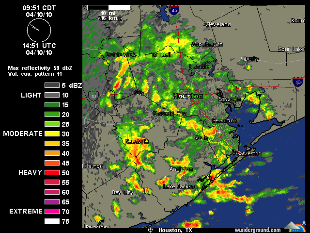
HGX has changed their tune. Pea sized hail? I'd believe it!
AREA FORECAST DISCUSSION
NATIONAL WEATHER SERVICE HOUSTON/GALVESTON TX
952 AM CDT SAT APR 10 2010
.DISCUSSION...
WATER VAPOR IMAGERY SHOWS A VIGOROUS SHORTWAVE APPROACHING SE TX.
LOW TO MID LEVEL MOISTURE HAS INCREASED WITH PWS OVER AN INCH AND
SFC DEWPOINTS IN THE MID/UPPER 50S. LIFT FROM THE SHORTWAVE IS
GENERATING SCATTERED CONVECTION OVER THE SRN HALF OF THE AREA.
CONVECTIVE COVERAGE HAS REALLY INCREASED OVER THE LAST HOUR WITH
FREQUENT OCCURRENCE OF LIGHTNING...INCLUDING CGS. WET BULB ZEROS
ARE QUITE LOW SO WILL WATCH FOR POSSIBILITY OF PEA- SIZED HAIL IF
ANY HIGHER VILS DEVELOP. HAVE ALREADY UPDATED FORECAST TO INCREASE
POPS TO 40 PCT FOR THE SOUTHERN THIRD. THE SHORTWAVE IS MOVING
QUICKLY...AND EXPECTING MOST OF THE ACTIVITY TO BE OUT OF THE AREA
BY 1 PM. WILL UPDATE THE FORECAST AGAIN AT THAT TIME.
35
Carla/Alicia/Jerry(In The Eye)/Michelle/Charley/Ivan/Dennis/Katrina/Rita/Wilma/Humberto/Ike/Harvey
Member: National Weather Association
Facebook.com/Weather Infinity
Twitter @WeatherInfinity
Member: National Weather Association
Facebook.com/Weather Infinity
Twitter @WeatherInfinity
-
wxdata

- Site Admin
- Posts: 1059
- Joined: Wed Feb 03, 2010 3:04 pm
- Location: Houston, TX
- Contact:
Thunder being heard in the Galleria area.
Also, HPC forecasts April-June will average below normal in the temperature department with above average to above average rains for Texas during the period..
Also, HPC forecasts April-June will average below normal in the temperature department with above average to above average rains for Texas during the period..
-
C2G

- Posts: 236
- Joined: Wed Feb 03, 2010 8:55 pm
- Location: NW Galveston County
- Contact:
Does anyone recall a mention of thunderstorms in the forecast today?
I recall just a 20% chance of rain, that's it. What's showing up on radar looks to be more than 20% coverage to me..........and those claps of thunder were pretty intense.
I recall just a 20% chance of rain, that's it. What's showing up on radar looks to be more than 20% coverage to me..........and those claps of thunder were pretty intense.
-
wxdata
- Site Admin
- Posts: 1059
- Joined: Wed Feb 03, 2010 3:04 pm
- Location: Houston, TX
- Contact:
Cloud2ground wrote:Does anyone recall a mention of thunderstorms in the forecast today?
I recall just a 20% chance of rain, that's it. What's showing up on radar looks to be more than 20% coverage to me..........and those claps of thunder were pretty intense.
Here the NWS forecast from 4am this morning-
TXZ213-102245-
HARRIS- INCLUDING THE CITIES OF...HOUSTON...HUMBLE...KATY...PASADENA...
TOMBALL
402 AM CDT SAT APR 10 2010
.TODAY...PARTLY CLOUDY. HIGHS IN THE MID 70S. SOUTHEAST WINDS 10 TO 15 MPH.
.TONIGHT...PARTLY CLOUDY. LOWS IN THE UPPER 50S. SOUTHEAST WINDS 10 TO 15 MPH.
.SUNDAY...PARTLY CLOUDY. HIGHS IN THE MID 70S. SOUTHEAST WINDS 5 TO 10 MPH.
.SUNDAY NIGHT...PARTLY CLOUDY. LOWS IN THE UPPER 50S. EAST WINDS 5 TO 10 MPH.
-
sleetstorm
- Posts: 651
- Joined: Thu Feb 04, 2010 12:33 pm
- Contact:
Hey Mr. T. Have you also been occupied with other things like some of us such as college or assisting your family with throwing away dead plants that were killed by the freezes?Mr. T wrote:Classic...
AREA FORECAST DISCUSSION...UPDATE MARINE
NATIONAL WEATHER SERVICE HOUSTON/GALVESTON TX
525 AM CDT SAT APR 10 2010
.DISCUSSION...
LATEST RADAR AND SATELLITE PICTURES DEPICT A DECENT SHORTWAVE MOVING
INTO OUR AREA FROM THE SOUTHWEST WITH SHOWERS AND THUNDERSTORMS WELL
OUT INTO THE GULF AND ACROSS PORTIONS OF DEEP SOUTH TEXAS. ONE MORE
DRY DAY IS IN STORE FOR SOUTHEAST TEXAS TODAY WITH SLOWLY RISING DEW
POINTS. RAIN CHANCE FORECAST FOR THE AREA GETS A LITTLE TRICKY AFTER
TODAY.
-
wxdata
- Site Admin
- Posts: 1059
- Joined: Wed Feb 03, 2010 3:04 pm
- Location: Houston, TX
- Contact:
Everyone- we love you to death and we're glad your here, but take personal questions to private mail please...
-
biggerbyte
- Posts: 1437
- Joined: Thu Feb 04, 2010 12:15 am
- Location: Porter, Texas. (Montgomery County)
- Contact:
Well, isn't this special? So much for that drought.... Lol
Pesky models...
Pesky models...
-
C2G
- Posts: 236
- Joined: Wed Feb 03, 2010 8:55 pm
- Location: NW Galveston County
- Contact:
Hate to say today's forecast is a bust, butttttt.
Thursday just got through doing my jog/power walk and decided to partake of a protein drink at a nutritional drink shop at the park. Owner said she was having a big get together on Saturday......slides and rides of all kinds. My brother and I both told her Saturday would be a great day for this shindig (weather wise).
Feel bad now.
-
ticka1
- Posts: 1265
- Joined: Wed Feb 03, 2010 3:02 pm
- Location: Baytown/Mont Belvieu
- Contact:
Definitely messing up the NHRA Spring Nationals at Houston Raceway Park - got rain and thunder here at the house. We live about 5 blocks from the racetrack.
Very dark and ominous to the south - heading this way. Its now 10:30 a.m. - this wasn't in the forecast - someone snoozed on this shortwave passing thru or just ignored it.
My garden needs this and is going to enjoy the rain.
Very dark and ominous to the south - heading this way. Its now 10:30 a.m. - this wasn't in the forecast - someone snoozed on this shortwave passing thru or just ignored it.
My garden needs this and is going to enjoy the rain.
-
wxdata
- Site Admin
- Posts: 1059
- Joined: Wed Feb 03, 2010 3:04 pm
- Location: Houston, TX
- Contact:
NWS-
"Spotter reports pea sized hail in Brazoria."
"Spotter reports pea sized hail in Brazoria."
-
sleetstorm
- Posts: 651
- Joined: Thu Feb 04, 2010 12:33 pm
- Contact:
Off topic this is, but in case you do not know this year marks the last year of the first decade of the 21st century and 3rd millennium. Next year marks the first year of the 2nd decade of the twenty-first century and 3rd millennium. The year 2000 was the last year of the 1990's, 1900's, and the second millennium.
-
sleetstorm
- Posts: 651
- Joined: Thu Feb 04, 2010 12:33 pm
- Contact:
I am also hearing some rumblings and boomings of thuder here in Baytown.
-
biggerbyte
- Posts: 1437
- Joined: Thu Feb 04, 2010 12:15 am
- Location: Porter, Texas. (Montgomery County)
- Contact:
Ed Mahmoud wrote:biggerbyte wrote:Well, isn't this special? So much for that drought.... Lol
Pesky models...
Drought is still on, below 0.5 inches of rain most areas per Nexrad rainfall estimate 6:30 to 11:45 am local. Its nice, but no drought buster.
You are kidding, right? The ground is still saturated from previous rains. At least in Porter it is. We got a nice bit of it today. There will be more bouts of rain like this in the coming days. So, unless you are confusing wet with dry...
What are we missing, Ed????
BB
-
wxdata
- Site Admin
- Posts: 1059
- Joined: Wed Feb 03, 2010 3:04 pm
- Location: Houston, TX
- Contact:
Next five days- not much heading our way, but central and south Texas are forecast to receive some much needed rains-