Hmm. So we have the Euro which is known for it's western bias this year and sure enough it shows a far western hit. Then you have the GFS which is known for breaking down the ridge to fast and overdoing trofs. Who shall we believe? As wxman said at this point in time we can only look at the general idea of the possible setup for that far out. The setup does look busy but as always things will change.
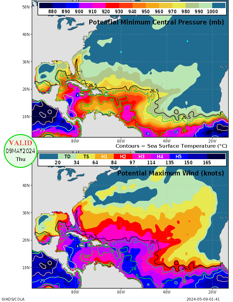
Wow look at SHIPS intensity!
TD Karl Inland West of Veracruz, MX
- srainhoutx
- Site Admin

- Posts: 19700
- Joined: Tue Feb 02, 2010 2:32 pm
- Location: Maggie Valley, NC
- Contact:
I believe wxman57 stated a while back that near the 10th of September to keep an eye on development in the Caribbean and Gulf for anything forming W of 55W. Right on cue! Yeah Andrew, the SHIPS warranted my Oh no post. Another area untouched by storms. This one may well be a big trouble maker down the road.
Carla/Alicia/Jerry(In The Eye)/Michelle/Charley/Ivan/Dennis/Katrina/Rita/Wilma/Humberto/Ike/Harvey
Member: National Weather Association
Facebook.com/Weather Infinity
Twitter @WeatherInfinity
Member: National Weather Association
Facebook.com/Weather Infinity
Twitter @WeatherInfinity
- txflagwaver
- Posts: 411
- Joined: Wed Feb 03, 2010 2:37 pm
- Location: Seabrook/Kemah
- Contact:
Mid September always the time to watch these things...Igor hopefully goes northward in the next few days,,,or the Gulf may be in trouble.
-
ticka1
- Posts: 1265
- Joined: Wed Feb 03, 2010 3:02 pm
- Location: Baytown/Mont Belvieu
- Contact:
txflagwaver wrote:Mid September always the time to watch these things...Igor hopefully goes northward in the next few days,,,or the Gulf may be in trouble.
I think what the modesl are picking up on for future GOM action is 92L - Igor will not be an issue for the GOM.
- srainhoutx
- Site Admin

- Posts: 19700
- Joined: Tue Feb 02, 2010 2:32 pm
- Location: Maggie Valley, NC
- Contact:
Interesting discussion out of San Juan, PR this morning...folks, we are going to have to keep a close eye on this one...
FEATURE OF INTEREST IS NOW A WEAK AREA OF LOW PRES EAST OF
TRINIDAD WHICH MODELS HAVE INDICATED SOME SORT OF WEAK TC
DEVELOPMENT OVR THE PAST COUPLE OF DAYS. THE RELIABLE MODELS ECMWF
AND GFS KEEP THIS SYSTEM JUST SOUTH OF THE AREA WITH THE ECMWF A
BIT FURTHER NORTH THAN THE GFS. PRIMARY THREAT FROM THIS SYSTEM
LOOKS TO BE HEAVY RAINFALL DUE TO ITS EXPECTED SLOW MOVEMENT.
TIMING UNCERTAINTIES NOTED BETWEEN THE MODELS WITH THE ECWMF
FASTER THAN THE GFS. HAVE SIDED WITH THE ECWMF BRINGING SOME GOOD
RAINS SAT AND SAT NIGHT AS THIS MODEL HAS OUTPERFORMED THE REST OF
THE OTHER GLOBAL MODELS THIS HURRICANE SEASON. MODELS HAVE ALSO
LAG BEHIND WITH OTHER TROPICAL CYCLONES AS WAS THE CASE WITH FAST
MOVING STORMS LIKE GASTON...COLIN AND FIONA. PEOPLE ARE ENCOURAGED
TO MONITOR LATEST FORECASTS OVR THE NEXT 48 HRS AS WE ARE VERY NEAR
THE CLIMATOLOGICAL PEAK OF THE HURRICANE SEASON AND TC DEVELOPMENT
CAN TAKE PLACE ABOUT ANYWHERE AND VERY QUICKLY. OF NOTE IS THE
UNRELIABLE MODELS CANADIAN GLOBAL AND NAM INDICATE THIS SYSTEM
ACTUALLY MOVING ACROSS PR ON SUN. GIVEN THAT THE H25 HIGH IS
EXPECTED TO WEAKEN AND UPPER LVL TROUGH XPCD TO CONTINUE TO DIG
SOUTH IS NOT OUT THE REALM OF POSSIBILITIES THAT THIS SYSTEM COULD
END UP FURTHER NORTH THAT WHAT IS SUGGESTED BY THE GFS/ECMWF
MODELS.
Carla/Alicia/Jerry(In The Eye)/Michelle/Charley/Ivan/Dennis/Katrina/Rita/Wilma/Humberto/Ike/Harvey
Member: National Weather Association
Facebook.com/Weather Infinity
Twitter @WeatherInfinity
Member: National Weather Association
Facebook.com/Weather Infinity
Twitter @WeatherInfinity
- srainhoutx
- Site Admin

- Posts: 19700
- Joined: Tue Feb 02, 2010 2:32 pm
- Location: Maggie Valley, NC
- Contact:
Keeping an eye near 12N/62W. Hi Res Vis Imagery suggests there may well be the beginning of some spin in that general area...
Carla/Alicia/Jerry(In The Eye)/Michelle/Charley/Ivan/Dennis/Katrina/Rita/Wilma/Humberto/Ike/Harvey
Member: National Weather Association
Facebook.com/Weather Infinity
Twitter @WeatherInfinity
Member: National Weather Association
Facebook.com/Weather Infinity
Twitter @WeatherInfinity
- srainhoutx
- Site Admin

- Posts: 19700
- Joined: Tue Feb 02, 2010 2:32 pm
- Location: Maggie Valley, NC
- Contact:
000
NOUS42 KNHC 091530
WEATHER RECONNAISSANCE FLIGHTS
CARCAH, NATIONAL HURRICANE CENTER, MIAMI, FL.
1130 AM EDT THU 09 SEPTEMBER 2010
SUBJECT: TROPICAL CYCLONE PLAN OF THE DAY (TCPOD)
VALID 10/1100Z TO 11/1100Z SEPTEMBER 2010
TCPOD NUMBER.....10-101
I. ATLANTIC REQUIREMENTS
1. NEGATIVE RECONNAISSANCE REQUIREMENTS.
2. SUCCEEDING DAY OUTLOOK: PSBL LOW LEVEL INVEST
NEAR 14.0N AND 64.0W FOR 11/1800Z.
3. REMARKS: THE NSF/NCAR G-V WILL FLY 2 A DAY RESEARCH MISSIONS
DEPARTING AT 10/0900Z AND 1700Z INTO THE SAME AREA.
Carla/Alicia/Jerry(In The Eye)/Michelle/Charley/Ivan/Dennis/Katrina/Rita/Wilma/Humberto/Ike/Harvey
Member: National Weather Association
Facebook.com/Weather Infinity
Twitter @WeatherInfinity
Member: National Weather Association
Facebook.com/Weather Infinity
Twitter @WeatherInfinity
-
ticka1
- Posts: 1265
- Joined: Wed Feb 03, 2010 3:02 pm
- Location: Baytown/Mont Belvieu
- Contact:
This keeps looking better and better on satellite pics. From last night to now...its increase convection - getting that "S" shape started- its not there yet but its close. Conscenus is that its on its way to becoming a TD if the convection remains.
- Katdaddy
- Global Moderator

- Posts: 2521
- Joined: Thu Feb 04, 2010 8:18 am
- Location: League City, Tx
- Contact:
This is the one to watch. Potential to become a hurricane before entering the GOM The forums should become very active over the weekend.
-
Scott747
- Posts: 1647
- Joined: Tue Feb 23, 2010 9:56 am
- Location: Freeport/Surfside Beach
- Contact:
0z GFS still showing a YP hit then into the Gulf and another hit in the Alex/Hermine area.
Not incredibly bullish on intensity for either hit and the movement/development continues to be slow.
Not incredibly bullish on intensity for either hit and the movement/development continues to be slow.
- srainhoutx
- Site Admin

- Posts: 19700
- Joined: Tue Feb 02, 2010 2:32 pm
- Location: Maggie Valley, NC
- Contact:
The 12Z Canadian takes the low N across the Leewards and into the Bahamas where it strengthens.
Carla/Alicia/Jerry(In The Eye)/Michelle/Charley/Ivan/Dennis/Katrina/Rita/Wilma/Humberto/Ike/Harvey
Member: National Weather Association
Facebook.com/Weather Infinity
Twitter @WeatherInfinity
Member: National Weather Association
Facebook.com/Weather Infinity
Twitter @WeatherInfinity
- srainhoutx
- Site Admin

- Posts: 19700
- Joined: Tue Feb 02, 2010 2:32 pm
- Location: Maggie Valley, NC
- Contact:
Looking better as the day wears on. You can almost see a banding structure developing...
Carla/Alicia/Jerry(In The Eye)/Michelle/Charley/Ivan/Dennis/Katrina/Rita/Wilma/Humberto/Ike/Harvey
Member: National Weather Association
Facebook.com/Weather Infinity
Twitter @WeatherInfinity
Member: National Weather Association
Facebook.com/Weather Infinity
Twitter @WeatherInfinity
- srainhoutx
- Site Admin

- Posts: 19700
- Joined: Tue Feb 02, 2010 2:32 pm
- Location: Maggie Valley, NC
- Contact:
12Z GFDL and HWRF are somewhat similar regarding track. Both suggest a trek near PR and on WNW. GFDL ends near Eastern Cuba, HWRF loses 92L just offshore of DR. Neither develop 92L to more than a TS. Way early to put much stock in the models IMO.
Carla/Alicia/Jerry(In The Eye)/Michelle/Charley/Ivan/Dennis/Katrina/Rita/Wilma/Humberto/Ike/Harvey
Member: National Weather Association
Facebook.com/Weather Infinity
Twitter @WeatherInfinity
Member: National Weather Association
Facebook.com/Weather Infinity
Twitter @WeatherInfinity
-
vci_guy2003
- Posts: 230
- Joined: Mon Jun 28, 2010 4:04 am
- Contact:
What does the SHIPS show for intensity ??
- srainhoutx
- Site Admin

- Posts: 19700
- Joined: Tue Feb 02, 2010 2:32 pm
- Location: Maggie Valley, NC
- Contact:
101 kts as of the 12Z outputvci_guy2003 wrote:What does the SHIPS show for intensity ??
Carla/Alicia/Jerry(In The Eye)/Michelle/Charley/Ivan/Dennis/Katrina/Rita/Wilma/Humberto/Ike/Harvey
Member: National Weather Association
Facebook.com/Weather Infinity
Twitter @WeatherInfinity
Member: National Weather Association
Facebook.com/Weather Infinity
Twitter @WeatherInfinity
- srainhoutx
- Site Admin

- Posts: 19700
- Joined: Tue Feb 02, 2010 2:32 pm
- Location: Maggie Valley, NC
- Contact:
12Z Euro suggests a weak system traveling across the Caribbean staying S of the Lesser Antiles and making landfall on the Yucatan next Thursday. It continues on into the BoC. Again, I would not put a lot of stock in these early runs, but it gives you an idea that we will likely be following this disturbance for at least 8-10 days.
Carla/Alicia/Jerry(In The Eye)/Michelle/Charley/Ivan/Dennis/Katrina/Rita/Wilma/Humberto/Ike/Harvey
Member: National Weather Association
Facebook.com/Weather Infinity
Twitter @WeatherInfinity
Member: National Weather Association
Facebook.com/Weather Infinity
Twitter @WeatherInfinity
-
Andrew
- Site Admin

- Posts: 3508
- Joined: Wed Feb 03, 2010 9:46 pm
- Location: North-West Houston
- Contact:
Things look to slowly be getting together. I did notice a lot of outflow boundaries to the east. If convection stays together into tomm we could get a Tropical Depression.
Current:

Microwave shows some rotation at the end:

Current steering levels look weak:

It is hot out there:

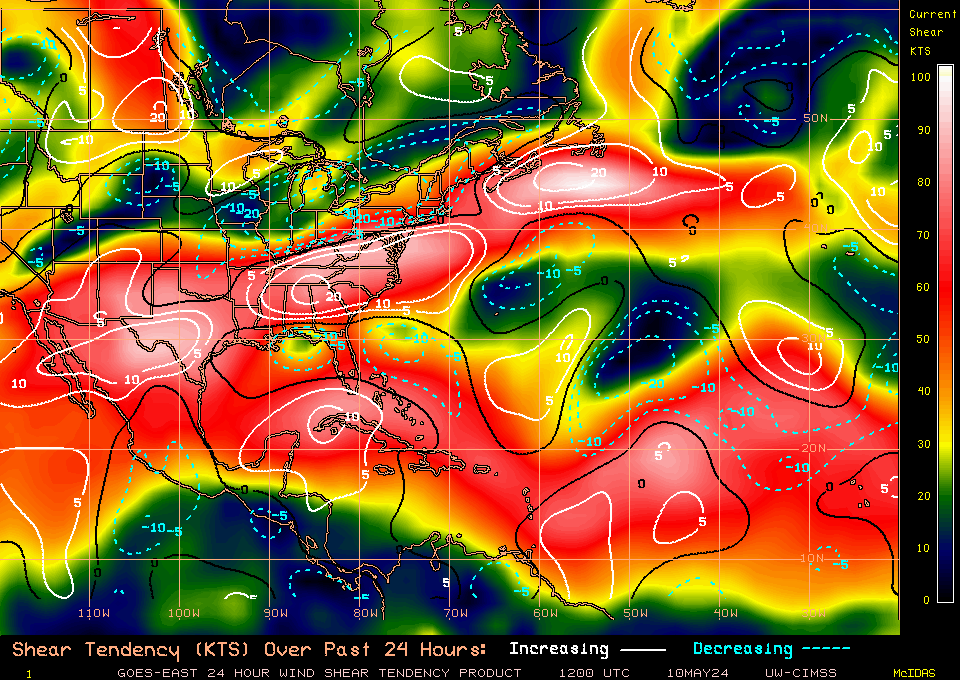
And last but not least shear could be what keeps it in check:

As Steve said, we shouldn't look at the models 8 days out for specifics on a landfall but know that we will be dealing with this storm for 8 days or so. Once a LLC is established and a couple of days move forward, we should have a better idea.
Current:

Microwave shows some rotation at the end:

Current steering levels look weak:
It is hot out there:

And last but not least shear could be what keeps it in check:
As Steve said, we shouldn't look at the models 8 days out for specifics on a landfall but know that we will be dealing with this storm for 8 days or so. Once a LLC is established and a couple of days move forward, we should have a better idea.
For Your Infinite Source For All Things Weather Visit Our Facebook
- srainhoutx
- Site Admin

- Posts: 19700
- Joined: Tue Feb 02, 2010 2:32 pm
- Location: Maggie Valley, NC
- Contact:
Pro Met CUmet on easternwx has stated that data from these mission will be included in the Euro ingest for 00Z Saturday. Also stated that the data may be in the GFS as well. We should have an actual center by then to track. Interesting weekend ahead. Also the ensembles (GFS and EC) are a bit concerning regarding a bit more northerly component in any future track. We shall see.srainhoutx wrote:000
NOUS42 KNHC 091530
WEATHER RECONNAISSANCE FLIGHTS
CARCAH, NATIONAL HURRICANE CENTER, MIAMI, FL.
1130 AM EDT THU 09 SEPTEMBER 2010
SUBJECT: TROPICAL CYCLONE PLAN OF THE DAY (TCPOD)
VALID 10/1100Z TO 11/1100Z SEPTEMBER 2010
TCPOD NUMBER.....10-101
I. ATLANTIC REQUIREMENTS
1. NEGATIVE RECONNAISSANCE REQUIREMENTS.
2. SUCCEEDING DAY OUTLOOK: PSBL LOW LEVEL INVEST
NEAR 14.0N AND 64.0W FOR 11/1800Z.
3. REMARKS: THE NSF/NCAR G-V WILL FLY 2 A DAY RESEARCH MISSIONS
DEPARTING AT 10/0900Z AND 1700Z INTO THE SAME AREA.
Carla/Alicia/Jerry(In The Eye)/Michelle/Charley/Ivan/Dennis/Katrina/Rita/Wilma/Humberto/Ike/Harvey
Member: National Weather Association
Facebook.com/Weather Infinity
Twitter @WeatherInfinity
Member: National Weather Association
Facebook.com/Weather Infinity
Twitter @WeatherInfinity
- srainhoutx
- Site Admin

- Posts: 19700
- Joined: Tue Feb 02, 2010 2:32 pm
- Location: Maggie Valley, NC
- Contact:
18Z Tracks...
Carla/Alicia/Jerry(In The Eye)/Michelle/Charley/Ivan/Dennis/Katrina/Rita/Wilma/Humberto/Ike/Harvey
Member: National Weather Association
Facebook.com/Weather Infinity
Twitter @WeatherInfinity
Member: National Weather Association
Facebook.com/Weather Infinity
Twitter @WeatherInfinity
-
Andrew
- Site Admin

- Posts: 3508
- Joined: Wed Feb 03, 2010 9:46 pm
- Location: North-West Houston
- Contact:
Yes steve and Ed Saturday should be a good idea of what will happen. Both the extra data and hopefully an actual LLC will lead to better runs. One thing for sure in the short turn a general NW- WNW track should proceed.
For Your Infinite Source For All Things Weather Visit Our Facebook