

Tropical Depression Bonnie forms 5:15 PM 7/22/2010
-
srainhoutx

- Site Admin

- Posts: 19700
- Joined: Tue Feb 02, 2010 2:32 pm
- Location: Maggie Valley, NC
- Contact:
Code: Select all
260
WHXX01 KWBC 191819
CHGHUR
TROPICAL CYCLONE GUIDANCE MESSAGE
NWS TPC/NATIONAL HURRICANE CENTER MIAMI FL
1819 UTC MON JUL 19 2010

DISCLAIMER...NUMERICAL MODELS ARE SUBJECT TO LARGE ERRORS.
PLEASE REFER TO NHC OFFICIAL FORECASTS FOR TROPICAL CYCLONE
AND SUBTROPICAL CYCLONE INFORMATION.

ATLANTIC OBJECTIVE AIDS FOR

DISTURBANCE INVEST (AL972010) 20100719 1800 UTC

        ...00 HRS...   ...12 HRS...   ...24 HRS. ..   ...36 HRS...
        100719  1800   100720  0600   100720  1800   100721  0600

         LAT    LON     LAT    LON     LAT    LON     LAT    LON
BAMS    19.2N  65.1W   20.2N  68.8W   21.5N  72.4W   22.0N  75.8W
BAMD    19.2N  65.1W   19.8N  67.0W   20.4N  68.9W   20.8N  70.6W
BAMM    19.2N  65.1W   19.9N  67.5W   20.5N  69.9W   20.7N  72.2W
LBAR    19.2N  65.1W   19.7N  67.6W   20.2N  70.5W   20.8N  73.5W
SHIP        25KTS          30KTS          36KTS          42KTS
DSHP        25KTS          30KTS          36KTS          42KTS

        ...48 HRS...   ...72 HRS...   ...96 HRS. ..   ..120 HRS...
        100721  1800   100722  1800   100723  1800   100724  1800

         LAT    LON     LAT    LON     LAT    LON     LAT    LON
BAMS    22.4N  79.0W   22.4N  85.6W   22.9N  91.4W   23.7N  95.9W
BAMD    21.1N  72.2W   21.8N  75.4W   22.3N  79.0W   23.7N  82.8W
BAMM    20.8N  74.4W   21.0N  78.4W   21.7N  82.1W   23.0N  85.4W
LBAR    21.4N  76.8W   22.8N  83.2W   24.7N  89.0W     .0N    .0W
SHIP        48KTS          60KTS          73KTS          82KTS
DSHP        48KTS          34KTS          50KTS          56KTS

         ...INITIAL CONDITIONS...
LATCUR =  19.2N LONCUR =  65.1W DIRCUR = 280DEG SPDCUR =  12KT
LATM12 =  18.8N LONM12 =  62.7W DIRM12 = 282DEG SPDM12 =  13KT
LATM24 =  18.1N LONM24 =  60.1W
WNDCUR =   25KT RMAXWD =   75NM WNDM12 =   25KT
CENPRS = 1014MB OUTPRS = 1017MB OUTRAD =  200NM SDEPTH =   S
RD34NE =    0NM RD34SE =    0NM RD34SW =    0NM RD34NW =   0NM
Carla/Alicia/Jerry(In The Eye)/Michelle/Charley/Ivan/Dennis/Katrina/Rita/Wilma/Humberto/Ike/Harvey
Member: National Weather Association
Facebook.com/Weather Infinity
Twitter @WeatherInfinity
Member: National Weather Association
Facebook.com/Weather Infinity
Twitter @WeatherInfinity


-
Hardcoreweather

-
srainhoutx
- Site Admin
- Posts: 19700
- Joined: Tue Feb 02, 2010 2:32 pm
- Location: Maggie Valley, NC
- Contact:
Keep an eye just NE of PR.

Carla/Alicia/Jerry(In The Eye)/Michelle/Charley/Ivan/Dennis/Katrina/Rita/Wilma/Humberto/Ike/Harvey
Member: National Weather Association
Facebook.com/Weather Infinity
Twitter @WeatherInfinity
Member: National Weather Association
Facebook.com/Weather Infinity
Twitter @WeatherInfinity
-
srainhoutx
- Site Admin
- Posts: 19700
- Joined: Tue Feb 02, 2010 2:32 pm
- Location: Maggie Valley, NC
- Contact:
Ed Mahmoud wrote:
While previewing- Steve typed a new post and said to look NE of Puerto Rico, except everything East of the DR-Haiti border has been chopped...
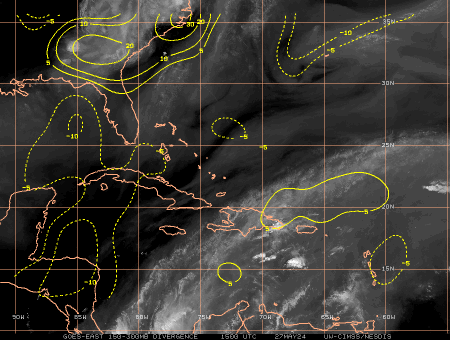
Hi RES Vis Imagery...
http://wwwghcc.msfc.nasa.gov/cgi-bin/ge ... mframes=15
Carla/Alicia/Jerry(In The Eye)/Michelle/Charley/Ivan/Dennis/Katrina/Rita/Wilma/Humberto/Ike/Harvey
Member: National Weather Association
Facebook.com/Weather Infinity
Twitter @WeatherInfinity
Member: National Weather Association
Facebook.com/Weather Infinity
Twitter @WeatherInfinity

-
srainhoutx
- Site Admin
- Posts: 19700
- Joined: Tue Feb 02, 2010 2:32 pm
- Location: Maggie Valley, NC
- Contact:
18Z Intensity Guidance suggest a Tropical Storm
Carla/Alicia/Jerry(In The Eye)/Michelle/Charley/Ivan/Dennis/Katrina/Rita/Wilma/Humberto/Ike/Harvey
Member: National Weather Association
Facebook.com/Weather Infinity
Twitter @WeatherInfinity
Member: National Weather Association
Facebook.com/Weather Infinity
Twitter @WeatherInfinity
-
redfish1
- Posts: 73
- Joined: Sat Jun 19, 2010 9:44 am
- Location: port arthur, tx
- Contact:
i may be wrong but isnt there supposed to be a high move in keeping it on a more westerly path???Hardcoreweather wrote:
-
srainhoutx
- Site Admin
- Posts: 19700
- Joined: Tue Feb 02, 2010 2:32 pm
- Location: Maggie Valley, NC
- Contact:
San Juan Radar...long range

Shorter range

Shorter range
Carla/Alicia/Jerry(In The Eye)/Michelle/Charley/Ivan/Dennis/Katrina/Rita/Wilma/Humberto/Ike/Harvey
Member: National Weather Association
Facebook.com/Weather Infinity
Twitter @WeatherInfinity
Member: National Weather Association
Facebook.com/Weather Infinity
Twitter @WeatherInfinity
-
srainhoutx
- Site Admin
- Posts: 19700
- Joined: Tue Feb 02, 2010 2:32 pm
- Location: Maggie Valley, NC
- Contact:
HGX thoughts...
WEEKEND WEATHER IS FORECAST TO BE MORE HOT AND RELATIVELY DRIER.
SLIGHT CHANCE WEEKEND POPS WITH DIURNAL EXTREME TEMPERATURES
INCREASING BY 2 TO 5 DEGREES FROM THURSDAY`S VALUES UNDER PARTLY
CLOUDY. OF NOTE...EURO WANTS TO BRING AN EASTERLY WAVE TO THE
TEXAS COAST BY SATURDAY WHILE GFS HOLDS OFF ON THIS IDEA UNTIL MON
OR TUE. IT APPEARS ENSEMBLE IS TILTING TOWARDS A MORE TRADITIONAL
LATE JULY PATTERN...WEAKER (FLATTENED) SOUTHERN PLAINS RIDGING...
INCREASED PROBABILITY OF THE HIGHER FREQUENCY OF EASTERN TROPICAL
WAVES/HIGHLY MOIST AIR MASSES HEADING INTO THE WESTERN GULF. 31
Carla/Alicia/Jerry(In The Eye)/Michelle/Charley/Ivan/Dennis/Katrina/Rita/Wilma/Humberto/Ike/Harvey
Member: National Weather Association
Facebook.com/Weather Infinity
Twitter @WeatherInfinity
Member: National Weather Association
Facebook.com/Weather Infinity
Twitter @WeatherInfinity


-
srainhoutx
- Site Admin
- Posts: 19700
- Joined: Tue Feb 02, 2010 2:32 pm
- Location: Maggie Valley, NC
- Contact:
18Z Para GFS @ 60 Hrs...
Carla/Alicia/Jerry(In The Eye)/Michelle/Charley/Ivan/Dennis/Katrina/Rita/Wilma/Humberto/Ike/Harvey
Member: National Weather Association
Facebook.com/Weather Infinity
Twitter @WeatherInfinity
Member: National Weather Association
Facebook.com/Weather Infinity
Twitter @WeatherInfinity
-
srainhoutx
- Site Admin
- Posts: 19700
- Joined: Tue Feb 02, 2010 2:32 pm
- Location: Maggie Valley, NC
- Contact:
114 hours...
Carla/Alicia/Jerry(In The Eye)/Michelle/Charley/Ivan/Dennis/Katrina/Rita/Wilma/Humberto/Ike/Harvey
Member: National Weather Association
Facebook.com/Weather Infinity
Twitter @WeatherInfinity
Member: National Weather Association
Facebook.com/Weather Infinity
Twitter @WeatherInfinity

-
Scott747
- Posts: 1648
- Joined: Tue Feb 23, 2010 9:56 am
- Location: Freeport/Surfside Beach
- Contact:
So it doesn't confuse anyone.
That's the 6z run of the HWRF. There wasn't a 12z run and the 18z should be out in a few minutes.
That's the 6z run of the HWRF. There wasn't a 12z run and the 18z should be out in a few minutes.
-
biggerbyte
- Posts: 1437
- Joined: Thu Feb 04, 2010 12:15 am
- Location: Porter, Texas. (Montgomery County)
- Contact:
In order for some of the suggested tracks to become valid, the ridge is going to have to weaken and move away quit a bit. A Texas, to Texas LA border makes more sense at this point. Everybody in the western gulf should watch this carefully.