
Yeah, I think so too. The parameters sure are looking nice. However, seeing a weakening trend back in SW TX for now. SPC did say the radar was overdoing the reflectivity earlier so perhaps that could be it. Regardless, that region is still being monitored for a possible severe t'storm watch.
http://radar.weather.gov/ridge/radar_li ... R&loop=yes
November: Cool & Dry To End The Month
-
wxman666

- Posts: 519
- Joined: Thu Jul 22, 2010 9:02 pm
- Location: Cypress, TX
- Contact:
Ready for severe weather season!!
-
wxman666
- Posts: 519
- Joined: Thu Jul 22, 2010 9:02 pm
- Location: Cypress, TX
- Contact:
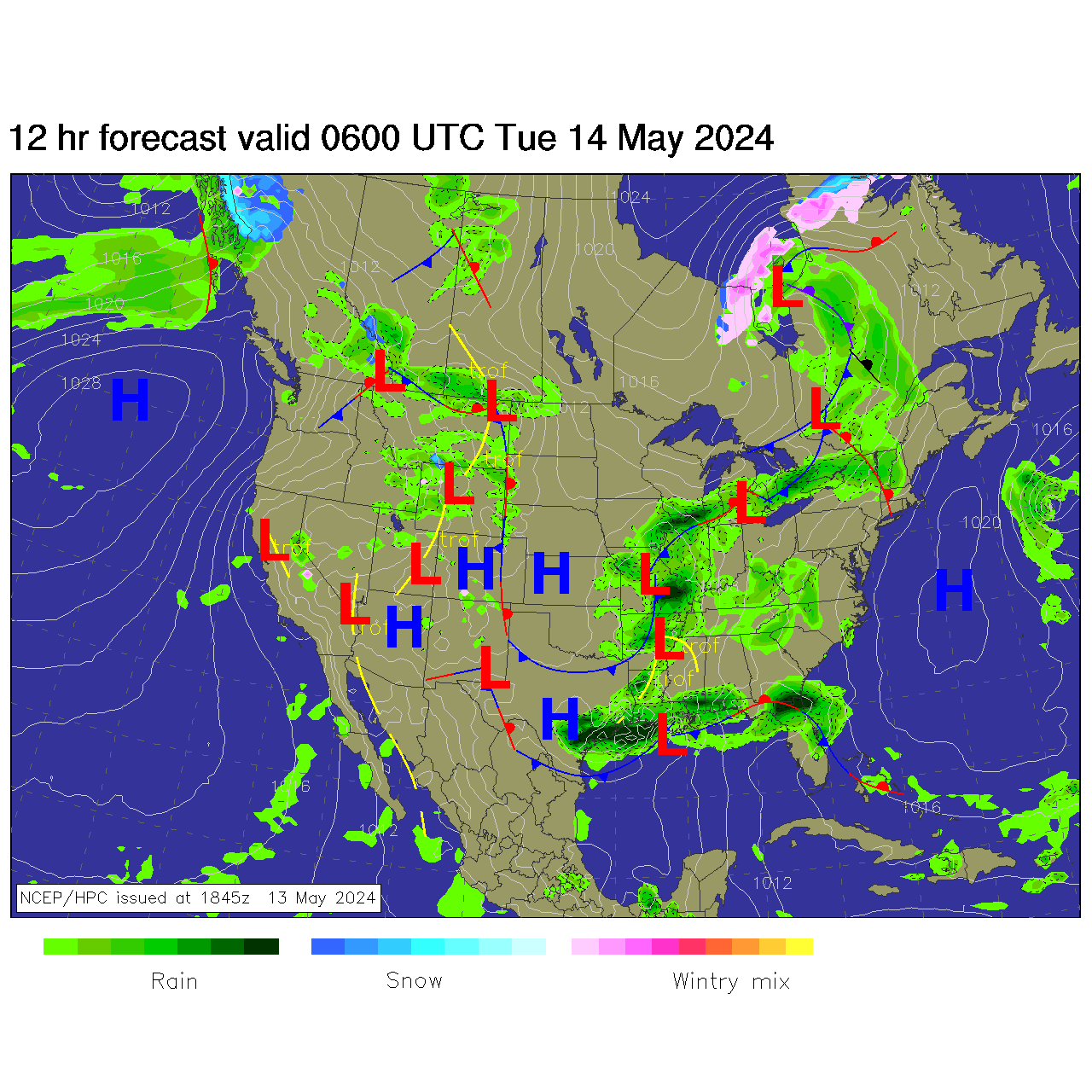
I like it. But they cut us out of the picture.Andrew wrote:Here is a NCEP/HPC chart of how things should look midday tomorrow:
Ready for severe weather season!!
-
Andrew
- Site Admin

- Posts: 3508
- Joined: Wed Feb 03, 2010 9:46 pm
- Location: North-West Houston
- Contact:
wxman666 wrote:Yeah, I think so too. The parameters sure are looking nice. However, seeing a weakening trend back in SW TX for now. SPC did say the radar was overdoing the reflectivity earlier so perhaps that could be it. Regardless, that region is still being monitored for a possible severe t'storm watch.
http://radar.weather.gov/ridge/radar_li ... R&loop=yes
Yea I think they were using a different type of mode for the radar. Earlier radar was indicating wide areas of 80+ DBZ which did not seem reasonable. If you look at water vapor though a lot of dry air is being pulled into the system. Let's see how this changes as more gulf moisture gets pulled in. Looking at the storm to the south of Del Rio and part of a hook is beginning to form. Looking at base velocity not much is coming up but something to keep an eye on.
For Your Infinite Source For All Things Weather Visit Our Facebook
-
wxman666
- Posts: 519
- Joined: Thu Jul 22, 2010 9:02 pm
- Location: Cypress, TX
- Contact:
Was just double checking the outlook and it looks like they're expecting rapid intensification between 9z and 12z....it just needs to take advantage of the gulf moisture. I'm betting by daybreak and later on, with some convective heating, we should really see things explode.Andrew wrote:wxman666 wrote:Yeah, I think so too. The parameters sure are looking nice. However, seeing a weakening trend back in SW TX for now. SPC did say the radar was overdoing the reflectivity earlier so perhaps that could be it. Regardless, that region is still being monitored for a possible severe t'storm watch.
http://radar.weather.gov/ridge/radar_li ... R&loop=yes
Yea I think they were using a different type of mode for the radar. Earlier radar was indicating wide areas of 80+ DBZ which did not seem reasonable. If you look at water vapor though a lot of dry air is being pulled into the system. Let's see how this changes as more gulf moisture gets pulled in. Looking at the storm to the south of Del Rio and part of a hook is beginning to form. Looking at base velocity not much is coming up but something to keep an eye on.
Ready for severe weather season!!
-
wxman666
- Posts: 519
- Joined: Thu Jul 22, 2010 9:02 pm
- Location: Cypress, TX
- Contact:
Severe Thunderstorm Warning
SEVERE THUNDERSTORM WARNING
TXC271-150845-
/O.NEW.KEWX.SV.W.0137.111115T0752Z-111115T0845Z/
BULLETIN - EAS ACTIVATION REQUESTED
SEVERE THUNDERSTORM WARNING
NATIONAL WEATHER SERVICE AUSTIN/SAN ANTONIO TX
152 AM CST TUE NOV 15 2011
THE NATIONAL WEATHER SERVICE IN AUSTIN SAN ANTONIO HAS ISSUED A
* SEVERE THUNDERSTORM WARNING FOR...
KINNEY COUNTY...
* UNTIL 245 AM CST.
* AT 149 AM CST...NWS METEOROLOGISTS HAVE DETECTED A SEVERE
THUNDERSTORM CAPABLE OF PRODUCING QUARTER SIZE HAIL...AND DAMAGING
WINDS IN EXCESS OF 60 MPH. THIS STORM WAS LOCATED 18 MILES
SOUTHWEST OF STANDART...AND MOVING NORTHEAST AT 35 MPH.
* SOME LOCATIONS IN THE WARNING INCLUDE AMANDA...BRACKETTVILLE AND
ALAMO VILLAGE.
PRECAUTIONARY/PREPAREDNESS ACTIONS...
THIS IS A DANGEROUS STORM. IF YOU ARE IN ITS PATH...PREPARE
IMMEDIATELY FOR DAMAGING WINDS...DESTRUCTIVE HAIL...AND DEADLY CLOUD
TO GROUND LIGHTNING. PEOPLE OUTSIDE SHOULD MOVE TO A SHELTER...
PREFERABLY INSIDE A STRONG BUILDING BUT AWAY FROM WINDOWS.
&&
LAT...LON 2924 10075 2963 10058 2928 10013 2908 10067
2911 10069 2911 10073 2917 10079 2920 10079
TIME...MOT...LOC 0752Z 217DEG 32KT 2913 10073
$$
SEVERE THUNDERSTORM WARNING
TXC271-150845-
/O.NEW.KEWX.SV.W.0137.111115T0752Z-111115T0845Z/
BULLETIN - EAS ACTIVATION REQUESTED
SEVERE THUNDERSTORM WARNING
NATIONAL WEATHER SERVICE AUSTIN/SAN ANTONIO TX
152 AM CST TUE NOV 15 2011
THE NATIONAL WEATHER SERVICE IN AUSTIN SAN ANTONIO HAS ISSUED A
* SEVERE THUNDERSTORM WARNING FOR...
KINNEY COUNTY...
* UNTIL 245 AM CST.
* AT 149 AM CST...NWS METEOROLOGISTS HAVE DETECTED A SEVERE
THUNDERSTORM CAPABLE OF PRODUCING QUARTER SIZE HAIL...AND DAMAGING
WINDS IN EXCESS OF 60 MPH. THIS STORM WAS LOCATED 18 MILES
SOUTHWEST OF STANDART...AND MOVING NORTHEAST AT 35 MPH.
* SOME LOCATIONS IN THE WARNING INCLUDE AMANDA...BRACKETTVILLE AND
ALAMO VILLAGE.
PRECAUTIONARY/PREPAREDNESS ACTIONS...
THIS IS A DANGEROUS STORM. IF YOU ARE IN ITS PATH...PREPARE
IMMEDIATELY FOR DAMAGING WINDS...DESTRUCTIVE HAIL...AND DEADLY CLOUD
TO GROUND LIGHTNING. PEOPLE OUTSIDE SHOULD MOVE TO A SHELTER...
PREFERABLY INSIDE A STRONG BUILDING BUT AWAY FROM WINDOWS.
&&
LAT...LON 2924 10075 2963 10058 2928 10013 2908 10067
2911 10069 2911 10073 2917 10079 2920 10079
TIME...MOT...LOC 0752Z 217DEG 32KT 2913 10073
$$
Ready for severe weather season!!
-
wxman666
- Posts: 519
- Joined: Thu Jul 22, 2010 9:02 pm
- Location: Cypress, TX
- Contact:
First SVR Warning. And so it begins. 
Ready for severe weather season!!
-
wxman666
- Posts: 519
- Joined: Thu Jul 22, 2010 9:02 pm
- Location: Cypress, TX
- Contact:
Okay now we're talking. Looks like the little bugger found its moisture.

Ready for severe weather season!!
-
Andrew
- Site Admin
- Posts: 3508
- Joined: Wed Feb 03, 2010 9:46 pm
- Location: North-West Houston
- Contact:
wxman666 wrote:Was just double checking the outlook and it looks like they're expecting rapid intensification between 9z and 12z....it just needs to take advantage of the gulf moisture. I'm betting by daybreak and later on, with some convective heating, we should really see things explode.Andrew wrote:wxman666 wrote:Yeah, I think so too. The parameters sure are looking nice. However, seeing a weakening trend back in SW TX for now. SPC did say the radar was overdoing the reflectivity earlier so perhaps that could be it. Regardless, that region is still being monitored for a possible severe t'storm watch.
http://radar.weather.gov/ridge/radar_li ... R&loop=yes
Yea I think they were using a different type of mode for the radar. Earlier radar was indicating wide areas of 80+ DBZ which did not seem reasonable. If you look at water vapor though a lot of dry air is being pulled into the system. Let's see how this changes as more gulf moisture gets pulled in. Looking at the storm to the south of Del Rio and part of a hook is beginning to form. Looking at base velocity not much is coming up but something to keep an eye on.
I am just hoping the cap doesn't give us much problem tomorrow.
For Your Infinite Source For All Things Weather Visit Our Facebook
-
wxman666
- Posts: 519
- Joined: Thu Jul 22, 2010 9:02 pm
- Location: Cypress, TX
- Contact:
Severe Thunderstorm Watch just issued. Will post asap.
Ready for severe weather season!!
-
wxman666
- Posts: 519
- Joined: Thu Jul 22, 2010 9:02 pm
- Location: Cypress, TX
- Contact:

BULLETIN - IMMEDIATE BROADCAST REQUESTED
SEVERE THUNDERSTORM WATCH OUTLINE UPDATE FOR WS 883
NWS STORM PREDICTION CENTER NORMAN OK
205 AM CST TUE NOV 15 2011
SEVERE THUNDERSTORM WATCH 883 IS IN EFFECT UNTIL 900 AM CST
FOR THE FOLLOWING LOCATIONS
TXC019-127-137-163-171-259-265-271-283-323-325-385-463-465-479-
507-151500-
/O.NEW.KWNS.SV.A.0883.111115T0805Z-111115T1500Z/
TX
. TEXAS COUNTIES INCLUDED ARE
BANDERA DIMMIT EDWARDS
FRIO GILLESPIE KENDALL
KERR KINNEY LA SALLE
MAVERICK MEDINA REAL
UVALDE VAL VERDE WEBB
ZAVALA
ATTN...WFO...EWX...CRP...
Last edited by wxman666 on Tue Nov 15, 2011 2:14 am, edited 1 time in total.
Ready for severe weather season!!
-
wxman666
- Posts: 519
- Joined: Thu Jul 22, 2010 9:02 pm
- Location: Cypress, TX
- Contact:
Seeing how that watch goes until 9 AM and isn't even into the Austin/San Antonio area yet...this stuff may be getting into our CWA a little later than expected. Looks like a slow mover.
Ready for severe weather season!!
-
Andrew
- Site Admin
- Posts: 3508
- Joined: Wed Feb 03, 2010 9:46 pm
- Location: North-West Houston
- Contact:
wxman666 wrote:Seeing how that watch goes until 9 AM and isn't even into the Austin/San Antonio area yet...this stuff may be getting into our CWA a little later than expected. Looks like a slow mover.
For sure. I think this thing will be in full force tomorrow right in the middle of daytime heating.
For Your Infinite Source For All Things Weather Visit Our Facebook
-
wxman666
- Posts: 519
- Joined: Thu Jul 22, 2010 9:02 pm
- Location: Cypress, TX
- Contact:
Andrew wrote:wxman666 wrote:Seeing how that watch goes until 9 AM and isn't even into the Austin/San Antonio area yet...this stuff may be getting into our CWA a little later than expected. Looks like a slow mover.
For sure. I think this thing will be in full force tomorrow right in the middle of daytime heating.
Hmmm....slow mover = training. Perhaps higher QPFs?
Ready for severe weather season!!
-
Andrew
- Site Admin
- Posts: 3508
- Joined: Wed Feb 03, 2010 9:46 pm
- Location: North-West Houston
- Contact:
wxman666 wrote:Andrew wrote:wxman666 wrote:Seeing how that watch goes until 9 AM and isn't even into the Austin/San Antonio area yet...this stuff may be getting into our CWA a little later than expected. Looks like a slow mover.
For sure. I think this thing will be in full force tomorrow right in the middle of daytime heating.
Hmmm....slow mover = training. Perhaps higher QPFs?
Possibly. I think it will mainly be intensity of storms that will decide QPF's Currently across central Texas streamer showers have already begun to form and this could stabilize the atmosphere somewhat tomorrow. On the other hand they could not form and have no impact. A lot of variables to watch but tomorrow looks rather active either way.
EDIT: More I look at the radar I def could see some training setting up tomorrow.
For Your Infinite Source For All Things Weather Visit Our Facebook
-
wxman666
- Posts: 519
- Joined: Thu Jul 22, 2010 9:02 pm
- Location: Cypress, TX
- Contact:
Yeah I kind of figured.
Ready for severe weather season!!
-
wxman666
- Posts: 519
- Joined: Thu Jul 22, 2010 9:02 pm
- Location: Cypress, TX
- Contact:
Wouldn't be too surprised to see EWX pull an FFA.
Ready for severe weather season!!
-
Andrew
- Site Admin
- Posts: 3508
- Joined: Wed Feb 03, 2010 9:46 pm
- Location: North-West Houston
- Contact:
wxman666 wrote:Wouldn't be too surprised to see EWX pull an FFA.
Yea maybe in the morning. Alright I am going to try to get a couple hours of sleep. See you at 7am.
For Your Infinite Source For All Things Weather Visit Our Facebook
-
wxman666
- Posts: 519
- Joined: Thu Jul 22, 2010 9:02 pm
- Location: Cypress, TX
- Contact:
Sounds like a plan.
Ready for severe weather season!!
-
srainhoutx

- Site Admin
- Posts: 19700
- Joined: Tue Feb 02, 2010 2:32 pm
- Location: Maggie Valley, NC
- Contact:
It looks like everything is pointing to an active day across the area. The SPC maintains a Slight Risk for all of SE TX with strong downbursts and hail the primary threaat. An Isolated tornado or two cannot be ruled out, so we'll need to monitor the radar as the morning moves along. Sounding suggest the cap has eroded, so conditions should begin to go downhill just after the morning rush hour. I would expect watches to expand eastward as the morning moves along with our Western areas getting in on the storm action around 10 AM or so. Stay Tuned as they say. It looks like a bumpy day ahead...
Carla/Alicia/Jerry(In The Eye)/Michelle/Charley/Ivan/Dennis/Katrina/Rita/Wilma/Humberto/Ike/Harvey
Member: National Weather Association
Facebook.com/Weather Infinity
Twitter @WeatherInfinity
Member: National Weather Association
Facebook.com/Weather Infinity
Twitter @WeatherInfinity
-
Katdaddy

- Global Moderator

- Posts: 2521
- Joined: Thu Feb 04, 2010 8:18 am
- Location: League City, Tx
- Contact:
We again have active weather to discuss today. Expecting strong to severe storms to move across SE TX this afternoon. Rush hour will a mess as the storms should be moving into and across Houston metro between 3-6PM.