
WUUS54 KHGX 200728
SVRHGX
TXC041-051-185-313-200830-
/O.NEW.KHGX.SV.W.0025.170220T0728Z-170220T0830Z/
BULLETIN - IMMEDIATE BROADCAST REQUESTED
Severe Thunderstorm Warning
National Weather Service Houston/Galveston TX
128 AM CST MON FEB 20 2017
The National Weather Service in League City has issued a
* Severe Thunderstorm Warning for...
Southeastern Burleson County in southeastern Texas...
Northern Grimes County in southeastern Texas...
Brazos County in southeastern Texas...
Madison County in southeastern Texas...
* Until 230 AM CST.
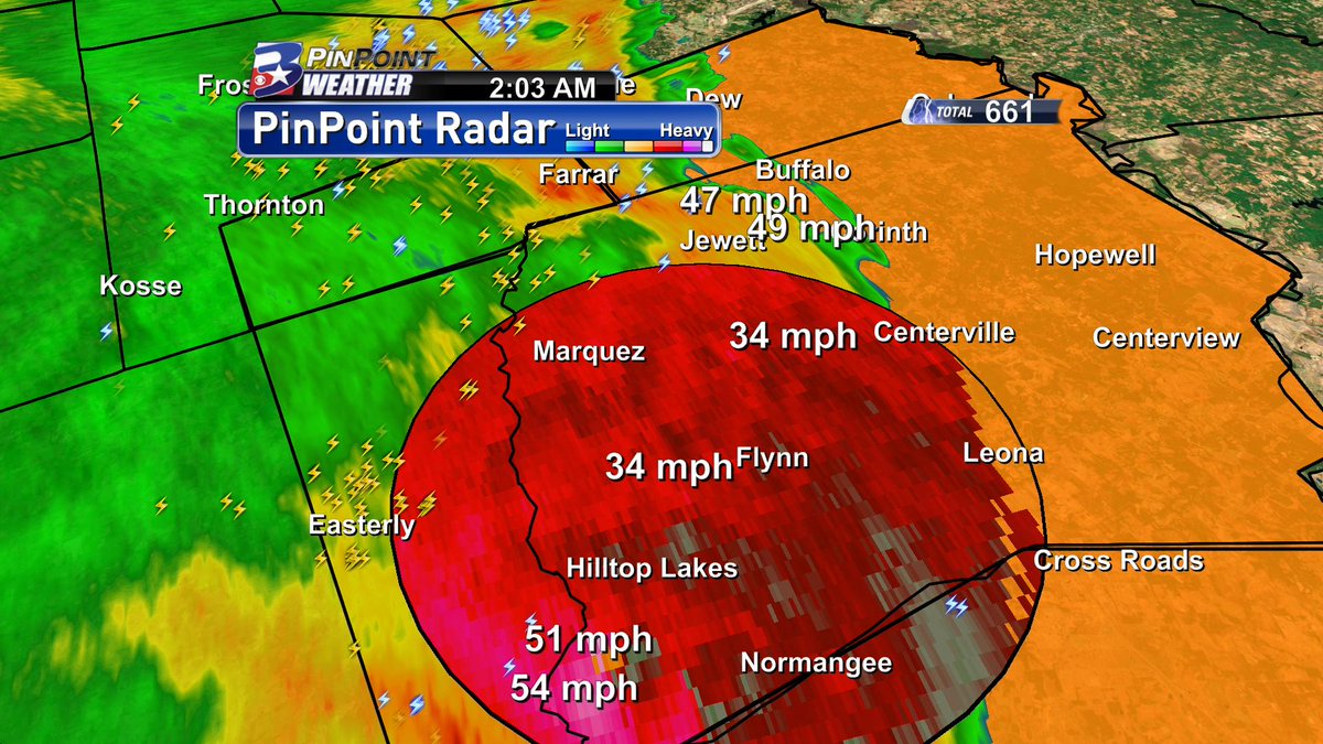
* At 127 AM CST, severe thunderstorms were located along a line
extending from near Hearne to near Bryan to near Snook, moving east
at 45 mph.
HAZARD...70 mph wind gusts.
SOURCE...Radar indicated.
IMPACT...Expect considerable tree damage. Damage is likely to
mobile homes, roofs, and outbuildings.
* Locations impacted include...
College Station, Bryan, Madisonville, Snook, Bedias, Kurten, Wixon
Valley, Millican, Anderson, Kyle Field, Iola, North Zulch,
Wellborn, Roans Prairie, Richards and Carlos.
February 2017- Spring Like Weather Returns
-
DoctorMu

- Posts: 8016
- Joined: Sun Jun 28, 2015 11:58 am
- Location: College Station
- Contact:
-
DoctorMu
- Posts: 8016
- Joined: Sun Jun 28, 2015 11:58 am
- Location: College Station
- Contact:
Hook echo on FM-46 SE of Franklin...moving 45-50 mph
-
DoctorMu
- Posts: 8016
- Joined: Sun Jun 28, 2015 11:58 am
- Location: College Station
- Contact:
Winds blustery - I haven't seen anything approaching 70 mph yet...
-
Andrew
- Site Admin

- Posts: 3508
- Joined: Wed Feb 03, 2010 9:46 pm
- Location: North-West Houston
- Contact:
Looks like areas from Wharton northeastward into Grimes & Montgomery will see the highest chances for flooding over the next couple of hours as the line has slowed down significantly. Eastward progression should continue later this morning as upper level energy catches up to the main line. We should see general weakening occur too once we hit the 5-6am time period.
For Your Infinite Source For All Things Weather Visit Our Facebook
-
Katdaddy

- Global Moderator

- Posts: 2521
- Joined: Thu Feb 04, 2010 8:18 am
- Location: League City, Tx
- Contact:
Severe Thunderstorm Warning
TXC015-089-157-201-473-477-481-201145-
/O.NEW.KHGX.SV.W.0028.170220T1109Z-170220T1145Z/
BULLETIN - IMMEDIATE BROADCAST REQUESTED
Severe Thunderstorm Warning
National Weather Service Houston/Galveston TX
509 AM CST MON FEB 20 2017
The National Weather Service in League City has issued a
* Severe Thunderstorm Warning for...
Northeastern Colorado County in southeastern Texas...
Northeastern Wharton County in southeastern Texas...
Eastern Austin County in southeastern Texas...
Southeastern Washington County in southeastern Texas...
Fort Bend County in southeastern Texas...
Southwestern Waller County in southeastern Texas...
West central Harris County in southeastern Texas...
* Until 545 AM CST.
* At 509 AM CST, severe thunderstorms were located along a line
extending from 10 miles east of Columbus to 7 miles east of Eagle
Lake to 6 miles northwest of Wharton, moving northeast at 45 mph.
HAZARD...60 mph wind gusts.
SOURCE...Radar indicated.
IMPACT...Expect damage to roofs, siding, and trees.
* Locations impacted include...
Sugar Land, Missouri City, Rosenberg, Stafford, Katy, Richmond,
Sealy, Hempstead, Brookshire, Bellville, Eagle Lake, Town West,
Pecan Grove, First Colony, Mission Bend, southwestern Eldridge /
West Oaks, Fresno, Meadows Place, East Bernard and Arcola.
PRECAUTIONARY/PREPAREDNESS ACTIONS...
For your protection move to an interior room on the lowest floor of a
building.
-
Katdaddy
- Global Moderator
- Posts: 2521
- Joined: Thu Feb 04, 2010 8:18 am
- Location: League City, Tx
- Contact:
BULLETIN - IMMEDIATE BROADCAST REQUESTED
Severe Thunderstorm Warning
National Weather Service Houston/Galveston TX
548 AM CST MON FEB 20 2017
The National Weather Service in League City has issued a
* Severe Thunderstorm Warning for...
Southeastern Grimes County in southeastern Texas...
Montgomery County in southeastern Texas...
Northeastern Fort Bend County in southeastern Texas...
Eastern Waller County in southeastern Texas...
South central Walker County in southeastern Texas...
Western Harris County in southeastern Texas...
* Until 630 AM CST.
* At 547 AM CST, severe thunderstorms were located along a line
extending from Waller to Pecan Grove, moving northeast at 50 mph.
HAZARD...60 mph wind gusts.
SOURCE...Radar indicated.
IMPACT...Expect damage to roofs, siding, and trees.
* Locations impacted include...
Sugar Land, Conroe, eastern Rosenberg, Stafford, Humble, Katy,
Richmond, Tomball, Jersey Village, Hempstead, Willis, Prairie View,
Hunters Creek Village, Bunker Hill Village, Piney Point Village,
Pinehurst, Northside / Northline, Kingwood, Spring Branch North and
The Woodlands.
PRECAUTIONARY/PREPAREDNESS ACTIONS...
For your protection move to an interior room on the lowest floor of a
building.
-
Cromagnum
- Posts: 3065
- Joined: Thu Feb 03, 2011 10:42 pm
- Location: Georgetown
- Contact:
Not much on the south side of town so far. More on the way though so we will see.
-
srainhoutx

- Site Admin
- Posts: 19700
- Joined: Tue Feb 02, 2010 2:32 pm
- Location: Maggie Valley, NC
- Contact:
Looks like HGX will be cancelling the Flash Flood Watch shortly. So far the storms have remained rather tame and nothing but stratiform rains behind the main line which is breaking up. Along the Coastal Counties, I would not let your guard down just yet. It appears a meso low is drifting to the ENE with some heavier rainfall rates possible.

Edit to Add:
Area Forecast Discussion
National Weather Service Houston/Galveston TX
742 AM CST Mon Feb 20 2017
.UPDATE...
The line of intense convection that moved into SE TX earlier this
morning has broken apart and intense convection has waned
significantly. The highest rainfall values have been out west over
Colorado, Burleson, Washington and Austin counties with about 3 to
4 inches of rain with most of that rain falling last night between
midnight and 2 AM. Flash flooding looks less likely as the
residual rain will be far less intense. Will drop the Flash Flood
Watch but still expecting periods of light to moderate rain to
linger through the mid afternoon. 43
Carla/Alicia/Jerry(In The Eye)/Michelle/Charley/Ivan/Dennis/Katrina/Rita/Wilma/Humberto/Ike/Harvey
Member: National Weather Association
Facebook.com/Weather Infinity
Twitter @WeatherInfinity
Member: National Weather Association
Facebook.com/Weather Infinity
Twitter @WeatherInfinity
-
srainhoutx
- Site Admin
- Posts: 19700
- Joined: Tue Feb 02, 2010 2:32 pm
- Location: Maggie Valley, NC
- Contact:
NWS San Antonio/Austin are sending out survey teams to the Quarry area of San Antonio and also possibly secondary team to Travis, Hayes, Bastrop and Williamson Counties to survey wind damage reports.
Carla/Alicia/Jerry(In The Eye)/Michelle/Charley/Ivan/Dennis/Katrina/Rita/Wilma/Humberto/Ike/Harvey
Member: National Weather Association
Facebook.com/Weather Infinity
Twitter @WeatherInfinity
Member: National Weather Association
Facebook.com/Weather Infinity
Twitter @WeatherInfinity
-
DoctorMu
- Posts: 8016
- Joined: Sun Jun 28, 2015 11:58 am
- Location: College Station
- Contact:
Fortunately the line crashed and burned once it hit Brazos Co about 2 am last night. Just a thorough soaking. Way to go Aggiedome.
-
srainhoutx
- Site Admin
- Posts: 19700
- Joined: Tue Feb 02, 2010 2:32 pm
- Location: Maggie Valley, NC
- Contact:
EWX confirms a tornado did touch down in the Quarry/Linda Drive area near 281 in San Antonio overnight. The survey team is looking at the damage to estimate the strength of that tornado.
Carla/Alicia/Jerry(In The Eye)/Michelle/Charley/Ivan/Dennis/Katrina/Rita/Wilma/Humberto/Ike/Harvey
Member: National Weather Association
Facebook.com/Weather Infinity
Twitter @WeatherInfinity
Member: National Weather Association
Facebook.com/Weather Infinity
Twitter @WeatherInfinity
-
Texaspirate11

- Posts: 1278
- Joined: Tue Dec 31, 2013 12:24 am
- Contact:
Bust.
But my family in San Antonio said their storm was intense.
But my family in San Antonio said their storm was intense.
Just because you're disabled, you don't have to be a victim
Be Weather Aware & Prepared!
Barbara Jordan Winner in Media
Disability Integration Consultant
Be Weather Aware & Prepared!
Barbara Jordan Winner in Media
Disability Integration Consultant
-
brooksgarner

- Global Moderator
- Posts: 226
- Joined: Tue Jun 04, 2013 3:06 pm
- Location: Houston, TX
- Contact:
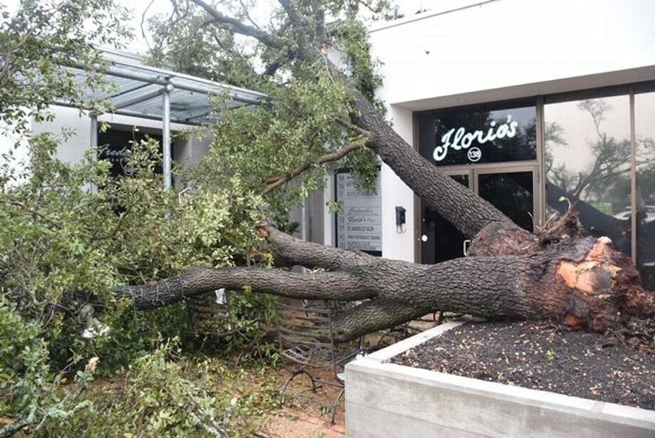
Looks like we escaped any sort of big flooding. Seems like models were right-on with guidance from last Friday with a progressive solution and a non-training vertical wind-field setup.
Isolated severe storms in San Antonio with that weak estimated EFO-EF1 tornado made for a rough day there...
Now, looking ahead to a beautiful week after a rainy Monday. Be safe on the roads, everyone!
Isolated severe storms in San Antonio with that weak estimated EFO-EF1 tornado made for a rough day there...
Now, looking ahead to a beautiful week after a rainy Monday. Be safe on the roads, everyone!
Broadcast Met
http://BrooksGarner.com
http://twitter.com/BrooksWeather
http://BrooksGarner.com
http://twitter.com/BrooksWeather
- '17 Harvey
- '12 Sandy (P3 Orion)
- '91 Bob
- '85 Gloria
-
Texaspirate11
- Posts: 1278
- Joined: Tue Dec 31, 2013 12:24 am
- Contact:
VERY happy we missed this one. According to my family, the Quarry area of San Antonio really got hit hard.
Onward to a lovely week -
Onward to a lovely week -
Just because you're disabled, you don't have to be a victim
Be Weather Aware & Prepared!
Barbara Jordan Winner in Media
Disability Integration Consultant
Be Weather Aware & Prepared!
Barbara Jordan Winner in Media
Disability Integration Consultant
-
houstonia
- Posts: 138
- Joined: Sun Jun 14, 2015 6:51 pm
- Location: Houston, Texas (Southwest side; Sharpstown)
- Contact:
I see a new storm causing trouble for the Pacific Northwest. Will this be our next storm system?
-
srainhoutx
- Site Admin
- Posts: 19700
- Joined: Tue Feb 02, 2010 2:32 pm
- Location: Maggie Valley, NC
- Contact:
Fortunately it looks like the strongest dynamics with that system will pass well to our North and not be a problem for our weekend ahead. The next storm system that may have some impact on our sensible weather appears to be around the First days of March.houstonia wrote:I see a new storm causing trouble for the Pacific Northwest. Will this be our next storm system?
Carla/Alicia/Jerry(In The Eye)/Michelle/Charley/Ivan/Dennis/Katrina/Rita/Wilma/Humberto/Ike/Harvey
Member: National Weather Association
Facebook.com/Weather Infinity
Twitter @WeatherInfinity
Member: National Weather Association
Facebook.com/Weather Infinity
Twitter @WeatherInfinity
-
unome
- Posts: 3062
- Joined: Fri Feb 12, 2010 6:11 pm
3 tornadoes confirmed by NWS San Antonio, 2-EF1 & 1-EF0
https://twitter.com/NWSSanAntonio
http://www.mysanantonio.com/news/weathe ... pid=brkbar
https://twitter.com/NWSSanAntonio
http://www.mysanantonio.com/news/weathe ... pid=brkbar
-
DoctorMu
- Posts: 8016
- Joined: Sun Jun 28, 2015 11:58 am
- Location: College Station
- Contact:
One more EF-0 for two pair. These cells over performed and raised a ruckus through Taylor and Snook before slamming into the "Aggiedome" at the Brazos River and more stable air. Given their rapid forward speed 50 mph I thought we were going to be slammed at least by high straight-line winds. Local peak gusts reached about 40-50 mph. Sure beat 70 mph.unome wrote:3 tornadoes confirmed by NWS San Antonio, 2-EF1 & 1-EF0
https://twitter.com/NWSSanAntonio
http://www.mysanantonio.com/news/weathe ... pid=brkbar
-
DoctorMu
- Posts: 8016
- Joined: Sun Jun 28, 2015 11:58 am
- Location: College Station
- Contact:
9 tornados confirmed for the Sun/Mon event.
Alamo Heights tornado upgraded to EF-2.

Alamo Heights tornado upgraded to EF-2.
-
srainhoutx
- Site Admin
- Posts: 19700
- Joined: Tue Feb 02, 2010 2:32 pm
- Location: Maggie Valley, NC
- Contact:
The afternoon ECMWF suggests a rather potent longwave trough approaching from the West as we end February and begin March.
- Attachments
-
Carla/Alicia/Jerry(In The Eye)/Michelle/Charley/Ivan/Dennis/Katrina/Rita/Wilma/Humberto/Ike/Harvey
Member: National Weather Association
Facebook.com/Weather Infinity
Twitter @WeatherInfinity
Member: National Weather Association
Facebook.com/Weather Infinity
Twitter @WeatherInfinity