November: Cool & Dry To End The Month

General Weather Discussions and Analysis
User avatar
wxman666
Posts: 519
Joined: Thu Jul 22, 2010 9:02 pm
Location: Cypress, TX
Contact:

srainhoutx wrote:Just the calm before the 'storm'. I'm sure you 'night owls' will be watching carefully... ;)

Image

Count me in Srain!! ;) Loading up on cokes, coffee, pizza and everything else. :lol:
Ready for severe weather season!!
biggerbyte
Posts: 1239
Joined: Thu Feb 04, 2010 12:15 am
Location: Porter, Texas. (Montgomery County)
Contact:

Hoot hoot
Andrew
Site Admin
Site Admin
Posts: 3481
Joined: Wed Feb 03, 2010 9:46 pm
Location: North-West Houston
Contact:

wxman666 wrote:
srainhoutx wrote:Just the calm before the 'storm'. I'm sure you 'night owls' will be watching carefully... ;)

http://radar.weather.gov/lite/N0R/DFX_loop.gif

Count me in Srain!! ;) Loading up on cokes, coffee, pizza and everything else. :lol:
I'll be here. Major test tomm :/

The trough is still digging to the east and hasn't gained much latitude. Water vapor is a good indication of the increasing moisture flow from the pacific and gulf.

http://weather.rap.ucar.edu/satellite/d ... uration=12

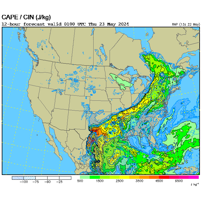
RUC indicates increasing CAPE over the day tomorrow and models such as the gfs have been continuously underplaying this system.

Image

500mb chart shows the lowering of heights to the west and that should only increase the thunderstorm activity as the shortwave continues to the east.

Image
Attachments
frame0.gif
For Your Infinite Source For All Things Weather Visit Our Facebook
ticka1
Posts: 1265
Joined: Wed Feb 03, 2010 3:02 pm
Location: Baytown/Mont Belvieu
Contact:

Wish I could stay up and watch this unfold but I got the J O B thing I have to go to tomorrow. I'll be up at 4:30 checking on things.

Ya'll make alot posts in here! Get this forum hopping!
User avatar
wxman666
Posts: 519
Joined: Thu Jul 22, 2010 9:02 pm
Location: Cypress, TX
Contact:

Oh yeah baby, I'm liking the looks of that CAPE and the height falls. Bring. It. On!!!
Ready for severe weather season!!
User avatar
wxman666
Posts: 519
Joined: Thu Jul 22, 2010 9:02 pm
Location: Cypress, TX
Contact:

Got the SPC homepage in my first open tab. Waiting on the 06z update. Andrew, where are you....and where's the rest of the night crew?? :)
Ready for severe weather season!!
Andrew
Site Admin
Site Admin
Posts: 3481
Joined: Wed Feb 03, 2010 9:46 pm
Location: North-West Houston
Contact:

wxman666 wrote:Got the SPC homepage in my first open tab. Waiting on the 06z update. Andrew, where are you....and where's the rest of the night crew?? :)

Haha I am right here. Keeping an eye on the radar. As for the rest of the crew the drought has scattered some people but many people will start checking in once things get more "active". I am heading over to the gym but will be back in about 45min-1 hour and will update then.
For Your Infinite Source For All Things Weather Visit Our Facebook
User avatar
wxman666
Posts: 519
Joined: Thu Jul 22, 2010 9:02 pm
Location: Cypress, TX
Contact:

Andrew wrote:
wxman666 wrote:Got the SPC homepage in my first open tab. Waiting on the 06z update. Andrew, where are you....and where's the rest of the night crew?? :)

Haha I am right here. Keeping an eye on the radar. As for the rest of the crew the drought has scattered some people but many people will start checking in once things get more "active". I am heading over to the gym but will be back in about 45min-1 hour and will update then.
Alright! I will go ahead and post the 06z update if no one else gets to it first.
Ready for severe weather season!!
unome
Posts: 3059
Joined: Fri Feb 12, 2010 6:11 pm

000
FXUS64 KHGX 150519
AFDHGX

AREA FORECAST DISCUSSION
NATIONAL WEATHER SERVICE HOUSTON/GALVESTON TX
1119 PM CST MON NOV 14 2011

.DISCUSSION...
MAIN CHANGES IN THIS TAF PACKAGE WERE TO SLIGHTLY MOVE TIMING OF
CONVECTION BACK A FEW HOURS. MVFR STRATUS EXPECTED TO FILL BACK IN
OVERNIGHT. UPPER LEVEL DISTURBANCE SEEN ON SAT PIX ACROSS N CNTL
MEXICO WILL CONTINUE EWD INTO TX LATER TONIGHT AND TUE. EXPECT
SHRA & TSTMS IN ADVANCE ACROSS THE RIO GRANDE VALLEY INTO THE
ARKLATEX LATE TONIGHT & EARLY TUE MORNING. EXPECT A LINE OF STORMS
TO APPROACH MATAGORDA-CLL REGION DURING THE LATE MORNING AND EARLY
AFTERNOON HOURS. IT`LL CONTINUE EASTWARD AND INTO THE I-45
TERMINALS 2-5PM. POTENTIAL IS THERE FOR STRONG TO SEVERE STORMS
WITH STRONG WINDS THE PRIMARY THREAT. ALTHOUGH THE STORM SYSTEM
WILL BE PROGRESSIVE IN NATURE, UPPER LEVEL CONDITIONS ARE ALSO
SOMEWHAT SUPPORTIVE OF STRONG TRAINING SW-TO-NE CELLS WITHIN THE
LINE PRODUCING A DECENT AMOUNT OF PRECIP AND VISIBILITY
RESTRICTIONS. MORE FAVORABLE LOCATION FOR THIS TO OCCUR WOULD BE
EAST OF AN COLUMBUS-MADISONVILLE LINE (GFS/ECMWF ACTUALLY SHOW QPF
BULLSEYE OVER HARRIS COUNTY). MAY SEE SOME WRAP AROUND PRECIP IN
THE CLL/UTS TERMINALS IN THE EVNG BUT ANTICIPATE FAIRLY
RAPID...BUT BRIEFLY IMPROVING CONDITIONS ELSEWHERE. WINDS SHOULD
LIE DOWN ALLOWING FOR SOME FOG DEVELOPMENT TUE NIGHT. 47
biggerbyte
Posts: 1239
Joined: Thu Feb 04, 2010 12:15 am
Location: Porter, Texas. (Montgomery County)
Contact:

All the players are coming together now to potentially give our area quite an event. As with all events, that is subject to change over the coming hours. For now, it looks really sweet.
biggerbyte
Posts: 1239
Joined: Thu Feb 04, 2010 12:15 am
Location: Porter, Texas. (Montgomery County)
Contact:

Completely agree with the "bring it on". Nothing more exciting than exciting weather, IMHO. :)
User avatar
wxman666
Posts: 519
Joined: Thu Jul 22, 2010 9:02 pm
Location: Cypress, TX
Contact:

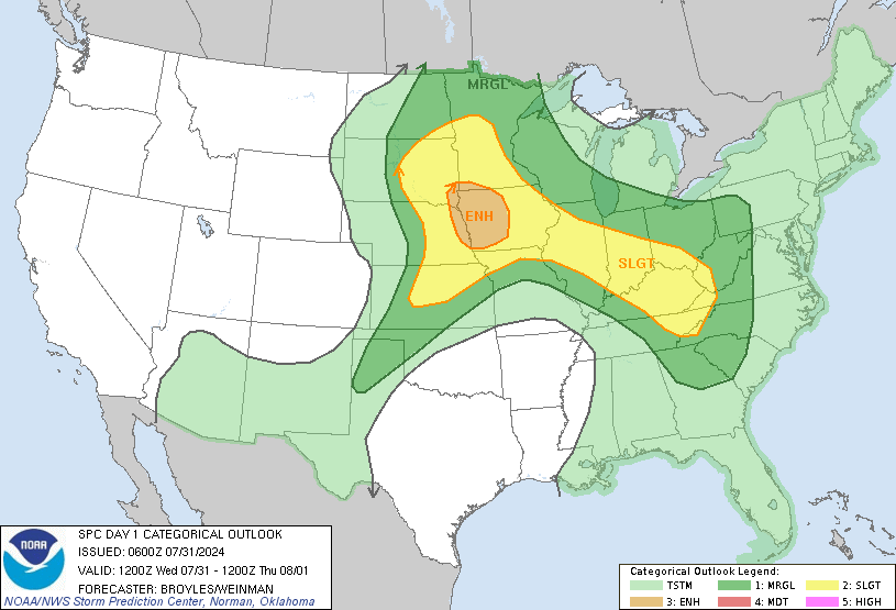
SPC Day 1 (06z/12 AM CT)

Image


DAY 1 CONVECTIVE OUTLOOK
NWS STORM PREDICTION CENTER NORMAN OK
1150 PM CST MON NOV 14 2011

VALID 151200Z - 161200Z

...THERE IS A SLGT RISK OF SVR TSTMS ACROSS PARTS OF THE SRN PLAINS
AND LOWER MS VALLEY...

...TX COASTAL PLAINS/SABINE RIVER VALLEY/LOWER MS VALLEY...
AN UPPER-LEVEL TROUGH WILL MOVE ACROSS THE RIO GRANDE VALLEY THIS
MORNING WITH A LINE OF THUNDERSTORMS ONGOING ON THE TX COASTAL
PLAINS AT 12Z. THIS LINE IS FORECAST TO MOVE EWD ACROSS SCNTRL AND
SE TX DURING THE MORNING JUST AHEAD OF A WELL-DEFINED VORTICITY MAX.
FORECAST SOUNDINGS ON THE TX COASTAL PLAINS AT 15Z TO 18Z SHOW A
MODERATELY UNSTABLE AIRMASS WITH SFC DEWPOINTS IN THE UPPER 60S F
AND 0-6 KM SHEAR VALUES IN THE 40 TO 50 KT RANGE. THIS ENVIRONMENT
MAY SUPPORT A WIND DAMAGE THREAT AS A LINEAR MCS MOVES EWD INTO THE
CORPUS CHRISTI AND HOUSTON AREAS AROUND MIDDAY.
THE UPPER-LEVEL
TROUGH AND ASSOCIATED MID-LEVEL JET MAX IS FORECAST TO MOVE INTO THE
LOWER MS VALLEY THIS AFTERNOON. AHEAD OF THE TROUGH...A BAND OF
LARGE-SCALE ASCENT AND A SLOWLY DESTABILIZING AIRMASS MAY ENABLE THE
CONVECTIVE LINE TO PERSIST THIS AFTERNOON WITH A WIND DAMAGE THREAT
DEVELOPING EWD INTO LA AND MS. THE MAIN ISSUE WITH THIS FORECAST IS
THAT THE MODELS DO NOT SHOW MUCH FOCUS WITH THIS SYSTEM. THIS
SUGGESTS THE WIND DAMAGE THREAT COULD BE INTERMITTENT AND DEPENDENT
UPON HOW MUCH DESTABILIZATION OCCURS ACROSS THE LOWER MS VALLEY.
THERE IS A POSSIBILITY THAT THE SEVERE THREAT COULD BE SPLIT INTO
SEPARATE AREAS WHERE INSTABILITY BECOMES MAXIMIZED.

THUNDERSTORM DEVELOPMENT WILL ALSO BE POSSIBLE THIS AFTERNOON
FURTHER NORTH ACROSS THE ARKLATEX AND IN THE SRN OZARKS.
HOWEVER...MODEL FORECASTS SHOW A WEAKNESS IN DEEP LAYER SHEAR ACROSS
MUCH OF AR AND NE TX SUGGESTING THE WIND DAMAGE THREAT SHOULD REMAIN
MARGINAL THERE. FURTHER TO THE EAST ACROSS THE TN VALLEY...FORECAST
SOUNDINGS BY LATE AFTERNOON SHOW STRONG DEEP LAYER SHEAR DUE TO A
BELT OF 50 TO 60 KT WINDS IN THE MID-LEVELS. THIS ALONG WITH WEAK
DESTABILIZATION AND 30 TO 40 KT AT 850 MB MAY BE ENOUGH FOR A
MARGINAL WIND DAMAGE THREAT AS THUNDERSTORMS DEVELOP IN THE LATE
AFTERNOON AND EARLY EVENING.
Last edited by wxman666 on Tue Nov 15, 2011 1:50 am, edited 1 time in total.
Ready for severe weather season!!
User avatar
wxman666
Posts: 519
Joined: Thu Jul 22, 2010 9:02 pm
Location: Cypress, TX
Contact:

New MCD out from the SPC. Watch possible in SW TX.

Image

http://www.spc.noaa.gov/products/md/md2321.html
Last edited by wxman666 on Tue Nov 15, 2011 1:51 am, edited 1 time in total.
Ready for severe weather season!!
biggerbyte
Posts: 1239
Joined: Thu Feb 04, 2010 12:15 am
Location: Porter, Texas. (Montgomery County)
Contact:

KDFX Radar looks nasty.
User avatar
wxman666
Posts: 519
Joined: Thu Jul 22, 2010 9:02 pm
Location: Cypress, TX
Contact:

Notice SPC isn't biting on tornadic potential so much just yet, but I have a gut feeling that may change, especially if daytime heating kicks in. Tornado probs ended up being increased last Tuesday.
Ready for severe weather season!!
User avatar
wxman666
Posts: 519
Joined: Thu Jul 22, 2010 9:02 pm
Location: Cypress, TX
Contact:

Does anyone have an updated image of tomorrow morning/afternoon's CAPE values or is it too soon?
Ready for severe weather season!!
Andrew
Site Admin
Site Admin
Posts: 3481
Joined: Wed Feb 03, 2010 9:46 pm
Location: North-West Houston
Contact:

wxman666 wrote:Does anyone have an updated image of tomorrow morning/afternoon's CAPE values or is it too soon?

Here is 1700 UTC from the RUC:

Image
For Your Infinite Source For All Things Weather Visit Our Facebook
User avatar
wxman666
Posts: 519
Joined: Thu Jul 22, 2010 9:02 pm
Location: Cypress, TX
Contact:

Andrew wrote:
wxman666 wrote:Does anyone have an updated image of tomorrow morning/afternoon's CAPE values or is it too soon?

Here is 1700 UTC from the RUC:

Image
Awesome. Ok Andrew, my eyes aren't too good. Does that show 2500 j/kg over us?
Ready for severe weather season!!
Andrew
Site Admin
Site Admin
Posts: 3481
Joined: Wed Feb 03, 2010 9:46 pm
Location: North-West Houston
Contact:

wxman666 wrote:
Andrew wrote:
wxman666 wrote:Does anyone have an updated image of tomorrow morning/afternoon's CAPE values or is it too soon?

Here is 1700 UTC from the RUC:

Image
Awesome. Ok Andrew, my eyes aren't too good. Does that show 2500 j/kg over us?

I believe so. Maybe a little less than that but around there. Should be interesting to see if it verifies and how the cloud cover could reduce thunderstorm activity tomorrow.
For Your Infinite Source For All Things Weather Visit Our Facebook
Andrew
Site Admin
Site Admin
Posts: 3481
Joined: Wed Feb 03, 2010 9:46 pm
Location: North-West Houston
Contact:

Here is a NCEP/HPC chart of how things should look midday tomorrow:

Image
For Your Infinite Source For All Things Weather Visit Our Facebook
Post Reply
  • Information
  • Who is online

    Users browsing this forum: Bing [Bot] and 53 guests