
August 2020:
-
sau27
- Posts: 415
- Joined: Sat Apr 24, 2010 12:04 am
- Location: Bellaire
- Contact:
*Throws hands up.gif*
-
weatherguy425
- Pro Met

- Posts: 830
- Joined: Wed Feb 03, 2010 7:45 pm
- Location: Atlanta, Georgia
- Contact:
• run off different parent models
• different sets, types of data put into them
Technically, the “global” models’ operational runs are in line with these. It is the ensemble ( various members of those models) group that is different.
Strength is also a key here. Stronger, sooner? West!
-
javakah
- Posts: 142
- Joined: Thu Jun 02, 2016 9:20 pm
- Location: Fulshear
- Contact:
Repeating myself from yesterday:
Wipe left, wipe right, wipe left...
Wipe left, wipe right, wipe left...
-
mcheer23
- Global Moderator

- Posts: 606
- Joined: Fri Jan 11, 2013 11:15 am
- Location: Missouri City/ Sugar Land
- Contact:
FWIW ...a model nobody really uses...NAVGEM shifted west into galveston lol
-
Stormlover2020
- Posts: 565
- Joined: Mon Jun 01, 2020 6:04 pm
- Contact:
-
txbear
- Posts: 249
- Joined: Wed Oct 31, 2018 12:54 pm
- Contact:
And what's more, seems like the majority are tightly clustered around the Galveston Bay landfall. Ensembles must be picking up a stronger ridge and/or stronger Laura than what the operationals are putting together. Let's make this more complex!
-
vci_guy2003
- Posts: 231
- Joined: Mon Jun 28, 2010 4:04 am
- Contact:
If Laura were to bomb to a cat 4 in the next 24 hours would that change the track reasoning?
-
Cpv17
- Posts: 7091
- Joined: Fri Aug 31, 2018 1:58 pm
- Location: El Campo/Wharton
- Contact:
I believe a stronger storm would go more west.vci_guy2003 wrote: ↑Mon Aug 24, 2020 2:45 pm If Laura were to bomb to a cat 4 in the next 24 hours would that change the track reasoning?
-
sau27
- Posts: 415
- Joined: Sat Apr 24, 2010 12:04 am
- Location: Bellaire
- Contact:
It doesn’t appear NHC is giving a whole lot of credence to the euro ensembles so I wouldn’t expect this 12z ensemble run to change the official track.
-
DoctorMu

- Posts: 8016
- Joined: Sun Jun 28, 2015 11:58 am
- Location: College Station
- Contact:
Holy whiplash, again, Batman!
-
DoctorMu
- Posts: 8016
- Joined: Sun Jun 28, 2015 11:58 am
- Location: College Station
- Contact:
Exactly.Cpv17 wrote: ↑Mon Aug 24, 2020 2:48 pmI believe a stronger storm would go more west.vci_guy2003 wrote: ↑Mon Aug 24, 2020 2:45 pm If Laura were to bomb to a cat 4 in the next 24 hours would that change the track reasoning?
-
DoctorMu
- Posts: 8016
- Joined: Sun Jun 28, 2015 11:58 am
- Location: College Station
- Contact:
Something to keep in mind as the potential track of Laura swings 100 miles east or west with the models and ensembles: huge wind field.
- Attachments
-
-
Ace
- Posts: 35
- Joined: Sun Jan 06, 2019 6:07 pm
- Location: Spring
- Contact:
This just came out.....
- Attachments
-
-
vci_guy2003
- Posts: 231
- Joined: Mon Jun 28, 2010 4:04 am
- Contact:
Are the models still showing a cat 4 deepening storm as it approaches the coast ?
-
Kingwood36
- Posts: 1592
- Joined: Sat Dec 29, 2018 10:29 am
- Location: Freeport
- Contact:
What are the odds our coast line gets a watch or a warning?
-
Cpv17
- Posts: 7091
- Joined: Fri Aug 31, 2018 1:58 pm
- Location: El Campo/Wharton
- Contact:
Maybe a couple. Most show cat 2 or 3. But a cat 4 is possible.vci_guy2003 wrote: ↑Mon Aug 24, 2020 3:12 pm Are the models still showing a cat 4 deepening storm as it approaches the coast ?
-
Cpv17
- Posts: 7091
- Joined: Fri Aug 31, 2018 1:58 pm
- Location: El Campo/Wharton
- Contact:
I would say pretty decent odds of that.Kingwood36 wrote: ↑Mon Aug 24, 2020 3:31 pm What are the odds our coast line gets a watch or a warning?
-
djjordan

- Posts: 929
- Joined: Fri Feb 05, 2010 7:19 pm
- Location: Montgomery, Texas
- Contact:
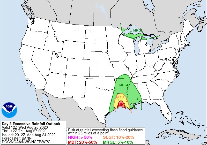
WPC Day 3 outlook for Flood Risk
~~~When Thunder Roars Go Indoors~~~
~~~Turn Around Don't Drown~~~
~~~Run From The Water, Hide From The Wind~~~
~~~Turn Around Don't Drown~~~
~~~Run From The Water, Hide From The Wind~~~
-
tireman4

- Global Moderator
- Posts: 7123
- Joined: Wed Feb 03, 2010 9:24 pm
- Location: Humble, Texas
- Contact:
Back at the Hacienda...
000
FXUS64 KHGX 241615
AFDHGX
Area Forecast Discussion
National Weather Service Houston/Galveston TX
1115 AM CDT Mon Aug 24 2020
.AVIATION [18Z TAF Issuance]...
Fairly straightforward TAFs this cycle, mainly to account for
diurnal wind shifts. Some MVFR-level clouds may pop up overnight
as more moisture moves into the area from the east, but ceilings
are more likely to be east of all terminals for this forecast
period. Showers and storms should stay mainly offshore, so no
mention of rain explicitly, but an isolated shower or two may pop
up over land as well.
&&
.PREV DISCUSSION /Issued 443 AM CDT Mon Aug 24 2020/...
.SHORT TERM [Through Tuesday]...
With low-level moisture increasing from the Gulf, scattered activity
will continue to develop and move into the coastal portions of SE TX
this morning. Coverage should become more isolated by this afternoon
across inland parts of our CWA even with Tropical Storm Marco moving
into/across southern LA today (per the slightly drier air mass wrap-
ping around into the region). From satellite/radar, Marco is still a
fairly unorganized system this morning and its impacts to SE TX will
likely remain minimal...even if it does decide to track further west.
For now, will keep the higher POPs over our eastern/coastal counties
tonight...then more evenly dispersed across the CWA tomorrow as this
system (or its remnants) head in this direction. Winds should mostly
range from 10-15 MPH today with slightly higher speeds for the coast
and areas east of I-45 today...then slightly higher tomorrow. As for
temperatures, will continue to lean warmer than guidance today as it
has been verifying. 41
.LONG TERM, MARINE & TROPICAL...
At the start of the period, Laura is expected to be situated in the
central Gulf at hurricane strength. It should make steady northwest
progress then eventually take a turn to the north around the western
periphery of a high pressure area extending from the east coast.
Laura is expected to make landfall along the northwest Gulf Coast
late Wed.
The current official NHC forecast favors a track toward the
southwestern La coastline. There are always uncertainties in the
longer range forecasts, and of note eastern parts of the CWA are
within the fringes of the forecast cone. Residents across the area
should keep up with the latest forecasts and any emergency
management recommendations. Slight storm wobbles, center
reformation, and/or variations in the strength of the ridge to its
north could make considerable differences in the forecast...from
negligible impacts with a further eastward track to near hit from a
strong hurricane. Watches may be issued for portions of the Gulf Coast
later today.
Forecast confidence should generally improve after Laura moves into
the Gulf off of Cuba. The center should become better defined. In
addition, aircraft data should be able to examine and get a better
grasp the surrounding environmental conditions.
Based upon the current fcst of the system making landfall where the
4am CDT advisory depicts (to the east of our CWA) one might
generally expect:
Rainfall:
- Look for some far outer rain bands to begin moving into parts of
the area late Tue into Wed, with increasing precip coverage across
southeast and east parts of the area as Laura approaches the coast
and moves inland. Assuming current track holds close, areas
generally east of the I-45 corridor should anticipate 1-4" (west-to-
east) with higher totals in any training banding between today and
Friday. Less rain with an eastward track & more with a westward
shift.
Winds:
- Any given location generally east of I-45 has between a 40-60%
chance of experiencing tropical storm force winds. Chances
lower the further west one goes. Areas along a line from
Matagorda Bay-College Station have a 10-30% risk. Most likely
time of arrival would be during the day Wednesday offshore and
immediate coast...and Wednesday evening and night further
inland. That being said, outer rain bands arriving earlier may
produce brief intermittent wind gusts to or above 34kt.
Surge/Tides:
- Too early for specifics. Highly dependent of track/intensity.
Highest to the north and east of landfall. That said, there
appears to be a fairly decent risk of coastal flooding for most
of the upper coast, especially east of Sargent from high surf
and wave run-up regardless of surge values. Additional
surge/elevated tides would enhance overall levels. For planning
purposes, inundation could occur as early as
Wednesday...especially beaches and Gulf facing locations.
Tornadoes:
- Too early to say. Most favorable locations would be in the
northeast quadrant of the cyclone. Current fcst has us on the
less favorable western side.
Seas/marine:
- 3-5 ft swell associated with Marco today will fade tonight/Tue.
- Laura swell begins arriving during the day Wed with seas
building o 7-14 feet by sunset. Peak seas and timing are
uncertain & dependent on intensity and track. Could be much
higher with a westward shift and lower with eastward shift.
Beach:
- Favorable angle of approach will drive a higher, long period
swell to the upper coast which will produce large breaking
waves (regardless of wind direction) as the day progresses
Wednesday into Wed night.
- Expect considerable wave run-up on area beaches which in itself
could cause coastal flooding. Potentially even more significant
around times of high tide AND on top of any surge (strongly
dependent on eventual track).
- Anticipate dangerous rip currents.
Again, sensible mid-late week wx is dependent on Laura`s evolution.
Going into the weekend, we should still lie in somewhat of a
weakness aloft so would expect some sct diurnal precip & maybe some
far sw side banding from Laura`s remnants far to our ne. 47
&&
.PRELIMINARY POINT TEMPS/POPS...
College Station (CLL) 97 75 96 76 95 / 10 10 20 20 40
Houston (IAH) 96 78 95 78 94 / 10 10 30 20 40
Galveston (GLS) 94 81 93 82 90 / 20 10 30 50 60
&&
.HGX WATCHES/WARNINGS/ADVISORIES...
TX...None.
GM...None.
&&
$$
SHORT TERM...41
LONG TERM/MARINE/TROPICAL...47
AVIATION...Luchs
-
Waded
- Posts: 81
- Joined: Wed Aug 23, 2017 12:32 pm
- Contact:
Might want to consider getting those vehicles topped off with gas. The gas stations will run out quick if Laura actually does start heading this way.