
July 2024
-
Stratton20
- Posts: 5870
- Joined: Tue Feb 09, 2021 11:35 pm
- Location: College Station, Texas
- Contact:
00z CMC
- Attachments
-
- IMG_3258.png
- (361.38 KiB) Downloaded 3690 times
-
tireman4

- Global Moderator

- Posts: 7161
- Joined: Wed Feb 03, 2010 9:24 pm
- Location: Humble, Texas
- Contact:
072
FXUS64 KHGX 191121
AFDHGX
Area Forecast Discussion
National Weather Service Houston/Galveston TX
621 AM CDT Fri Jul 19 2024
...New AVIATION...
.SHORT TERM...
(Today through Saturday Night)
Issued at 211 AM CDT Fri Jul 19 2024
The boundary that moved into the area yesterday will be hanging
around SE Texas through tomorrow helping to bring continued
chances of showers and thunderstorms. There are a few isolated
showers occuring during the predawn hours today, but expect
coverage to ramp up during the late morning and through the
afternoon thanks to daytime heating. The boundary is fairly
diffuse, but the best chances for the afternoon thunderstorms will
be along and south of the boundary - currently hanging around
Brenham to Conroe to Romayor. The boundary should push further to
the coast during the afternoon bringing the rain chances with it.
Since the storms will be hit-or-miss, most places won`t see much
if any rainfall today, but the places that do could see up to 1 to
2 inches. WPC has maintained the Marginal Risk (level 1 of 4) for
areas generally east of I-69 for excessive rainfall. If we get
multiple storms over the same area, then we may see some ponding
in areas of poor drainage. There will be a lull in the activity
overnight with the loss of heating and the boundary staying near
or off the coast. Rain chances return Saturday afternoon, but with
the boundary likely staying off the coast through the day the
coverage will be much more limited.
Temperatures through the short term will be fairly consistent.
The high temperatures today and Saturday will be in the upper ups
to low 90s. Overnight low temperatures will be in the mid to upper
70s for most of the area with the immediate coast staying in the
low 80s.
Fowler
&&
.LONG TERM...
(Sunday through Thursday)
Issued at 211 AM CDT Fri Jul 19 2024
A rather stubborn wet weather pattern is expected through much of
the long term period with good chances for showers and
thunderstorms each day.
Southeast TX is expected to be wedged between two mid-upper level
ridges for several days and will allow for weakness aloft for an
extended period of time. Several pulses of warm moist air from
the Gulf of Mexico will be making their way into the local region
from time to time, increasing PWs to 1.8-2.3 inches. Considering
the combination of fairly good instability in place, several vort
maxes moving through, and lingering boundaries, multiple rounds
of showers and thunderstorms over the next several days are not
out of the question.
From Sunday to Tuesday, we will likely see a repetitive pattern
with showers and storms beginning over the waters and areas near
and south of I-10 and then progressing northward and further
inland later in the morning to early evening. Although activity
will decrease in the evening and early night hours, some isolated
showers will still be possible overnight. On Wednesday, an even
stronger surge of moisture will move across the region, elevating
PWs into the 2.2-2.5 inches range and could make it our rainiest
day of the week. We will continue to see rain chances on Thursday.
Even though probabilities at this time may not be as high as
Wednesday, some of the Global models show slightly stronger vort
maxes passing through and may result in slightly higher rain
chances.
Environmental conditions will be favorable for periods of heavy
rainfall and could lead to localized minor flooding and ponding of
water on roadways. As we progress through early next week, areas
receiving good amounts of rainfall each day could become more and
more vulnerable to flood impacts, in particular for areas with
well saturated soils. Please keep updated with the latest
forecasts and have multiple ways of receiving weather alerts.
The good side of having all the rain and cloud coverage is that
temperatures will be on the "cooler" side in terms of our typical
summer temperatures with highs generally in the upper 80s to low
90s for much of Southeast TX. The highs on Wednesday may even
reach the mid 80s in several spots. Unfortunately, with high
levels of moisture in place, it will still feel pretty muggy and
damp at times. A bad side of all the rainfall, apart from the
threat of flooding, is that we may not see the end of these
dreaded vampire mosquitos, and you may find yourself fighting them
every time you open your home doors or running for your life when
getting into your vehicle these next few days. But jokes aside,
mosquitos have been known to bring about many diseases. Please
make sure to protect yourself and loved ones from mosquitos, and
yes...even pets need to be protected from these suckers (pun
intended).
Cotto (24)
&&
.AVIATION...
(12Z TAF Issuance)
Issued at 557 AM CDT Fri Jul 19 2024
Some patchy fog has developed at UTS and CXO this morning, but
should be dissipating after sunrise. A broken line of showers and
storms has developed along a weak boundary this is moving through
the region this morning. There is a notable break in the storms
along the I-45 corridor, so most terminals will be spared from
this round of storms (though cannot out rule a quick developing
shower). SGR and LBX will have the best chance of seeing some VCTS
this morning between 13-15z as the line moves through. There will
likely be some pop-up, isolated showers and storms this afternoon
as well due to daytime heating generally south of I-10. Otherwise,
VFR conditions will prevail through the day with light northerly
to northeasterly winds.
Fowler
&&
.MARINE...
Issued at 211 AM CDT Fri Jul 19 2024
Mainly light onshore flow and seas of 1 to 3 feet will prevail for
the next several days. There will be multiple rounds of showers
and storms for much of the forecast period and could result in
brief moments of stronger winds and elevated seas, in particular
in and around strong storms.
Cotto (24)
&&
.PRELIMINARY POINT TEMPS/POPS...
College Station (CLL) 91 73 93 73 / 10 10 10 0
Houston (IAH) 91 76 92 76 / 40 20 40 20
Galveston (GLS) 90 80 89 81 / 60 50 50 30
&&
.HGX WATCHES/WARNINGS/ADVISORIES...
TX...None.
GM...None.
&&
$$
SHORT TERM...Fowler
LONG TERM....Cotto (24)
AVIATION...Fowler
MARINE...Cotto (24)
-
jasons2k

- Posts: 6201
- Joined: Thu Feb 04, 2010 12:54 pm
- Location: Imperial Oaks
- Contact:
This is great summer weather for Texas. Reminds me of Florida. Everything is lush and green.
-
Cpv17
- Posts: 7109
- Joined: Fri Aug 31, 2018 1:58 pm
- Location: El Campo/Wharton
- Contact:
12z CMC:
-
Stratton20
- Posts: 5870
- Joined: Tue Feb 09, 2021 11:35 pm
- Location: College Station, Texas
- Contact:
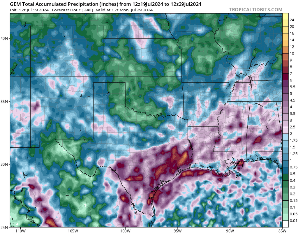
it will be interesting when mesoscale models get in range of the tuesday- thursday/friday time frame, thats when we have that more vigorous upper level low stalling out to our west sending spokes of energy/ heavy rain our way, the 12z CMC shows this, something to watch closely for a flash flooding set up
-
tireman4
- Global Moderator
- Posts: 7161
- Joined: Wed Feb 03, 2010 9:24 pm
- Location: Humble, Texas
- Contact:
.AVIATION...
(18Z TAF Issuance)
Issued at 1214 PM CDT Fri Jul 19 2024
This morning`s SHRA/TSRA seem to have stabilized much of the area. Most
recent set of models are only showing isolated activity this afternoon.
For now, will only carry late afternoon through early evening VCSH for
HOU-SGR-LBX-GLS along with mainly N to NE winds. Quiet this evening
with possible SHRA development toward morning LBX-GLS, and VRB winds.
SE winds developing/increasing tomorrow with possible SHRA/TSRA in the
afternoon.
-
DoctorMu

- Posts: 8091
- Joined: Sun Jun 28, 2015 11:58 am
- Location: College Station
- Contact:
-
Pas_Bon
- Posts: 968
- Joined: Tue Sep 11, 2018 7:58 am
- Location: League City, TX
- Contact:
-
tireman4
- Global Moderator
- Posts: 7161
- Joined: Wed Feb 03, 2010 9:24 pm
- Location: Humble, Texas
- Contact:
Just an FYI.....from the SPC...
- Attachments
-
- Storm Prediction Outlook .jpg (93.94 KiB) Viewed 5470 times
-
DoctorMu
- Posts: 8091
- Joined: Sun Jun 28, 2015 11:58 am
- Location: College Station
- Contact:
Yes, they are. Except, it's not a coincidence. They have our Death Ridge, which also sent Beryl toward Texas.Pas_Bon wrote: ↑Fri Jul 19, 2024 2:10 pmCoincidentally, North Carolina is having a Texas Summer this year. Lol
-
Cpv17
- Posts: 7109
- Joined: Fri Aug 31, 2018 1:58 pm
- Location: El Campo/Wharton
- Contact:
Idk about that. They’ve been getting scattered storms there each day lately. Today too.Pas_Bon wrote: ↑Fri Jul 19, 2024 2:10 pmCoincidentally, North Carolina is having a Texas Summer this year. Lol
-
Stratton20
- Posts: 5870
- Joined: Tue Feb 09, 2021 11:35 pm
- Location: College Station, Texas
- Contact:
Their is a lot of moisture building up near the yucatan, that should get funneled directly into se texas by tuesday-friday, watching the flooding potential closely
-
Cpv17
- Posts: 7109
- Joined: Fri Aug 31, 2018 1:58 pm
- Location: El Campo/Wharton
- Contact:
Has anyone seen Twisters yet? I’m thinking about going to see it.
-
DoctorMu
- Posts: 8091
- Joined: Sun Jun 28, 2015 11:58 am
- Location: College Station
- Contact:
-
Stratton20
- Posts: 5870
- Joined: Tue Feb 09, 2021 11:35 pm
- Location: College Station, Texas
- Contact:
CMC is interesting, develops a LOW/ MCS and slowly moves it up the texas coastline, se texas gets absolutely hammered
-
Pas_Bon
- Posts: 968
- Joined: Tue Sep 11, 2018 7:58 am
- Location: League City, TX
- Contact:
Saw it last night. It was good. Very much not a sequel….its own film.
There were a couple gratuitous honorary mentions and proverbial/generalized nod to the OG film, but not much else.
Still….spoiler alert…..it had tornadoes in it.
-
Stratton20
- Posts: 5870
- Joined: Tue Feb 09, 2021 11:35 pm
- Location: College Station, Texas
- Contact:
WPC has a level 2/4 risk for excessive rainfall in se texas on thursday, wouldnt be surprised to see an increase to level 2 for both tuesday and wednesday here as well, maybe even a moderate risk for the later as the week progresses, tropical moisture + vigorous upper level low that is slow to clear out = a flooding setup
-
DoctorMu
- Posts: 8091
- Joined: Sun Jun 28, 2015 11:58 am
- Location: College Station
- Contact:
Those drier northerly breezes are paying off with DP's in the 60s. The slightest taste of Fall in late July.
-
Cpv17
- Posts: 7109
- Joined: Fri Aug 31, 2018 1:58 pm
- Location: El Campo/Wharton
- Contact:
Thanks! I’ve seen some early reviews and most are pretty positive.
-
Cpv17
- Posts: 7109
- Joined: Fri Aug 31, 2018 1:58 pm
- Location: El Campo/Wharton
- Contact:
Damn!