
Careful with that thought.Kingwood36 wrote: ↑Thu Aug 26, 2021 8:28 am I think this could be our last threat for the yr.. once these week cool front start heading towards us in September it's more then likely going to sweep anything east if here like it normally does
August 2021: Major Hurricane Ida/SE Louisiana Landfall
-
weatherguy425
- Pro Met

- Posts: 830
- Joined: Wed Feb 03, 2010 7:45 pm
- Location: Atlanta, Georgia
- Contact:
-
Cpv17
- Posts: 7077
- Joined: Fri Aug 31, 2018 1:58 pm
- Location: El Campo/Wharton
- Contact:
Not so sure about that.Kingwood36 wrote: ↑Thu Aug 26, 2021 8:28 am I think this could be our last threat for the yr.. once these week cool front start heading towards us in September it's more then likely going to sweep anything east if here like it normally does
-
cperk
- Posts: 857
- Joined: Sun Aug 19, 2012 12:09 pm
- Location: Richmond
- Contact:
-
weatherguy425
- Pro Met
- Posts: 830
- Joined: Wed Feb 03, 2010 7:45 pm
- Location: Atlanta, Georgia
- Contact:
On the larger than average size, but models are also hinting at subtle southwesterly/westerly shear. The system may not be perfectly symmetrical; east-side dominant.tireman4 wrote: ↑Thu Aug 26, 2021 8:31 amI wonder how massive (size) this storm will be. I suppose that is an ongoing question as the days wears on.weatherguy425 wrote: ↑Thu Aug 26, 2021 8:27 am Data continues to align with a Louisiana landfall. Today, early tomorrow is a time period to look for subtle shifts. But, overall, confidence is increasing in the forecast.
12Z Tropical Models -
-
cperk
- Posts: 857
- Joined: Sun Aug 19, 2012 12:09 pm
- Location: Richmond
- Contact:
I disagree with you on that.Cpv17 wrote: ↑Thu Aug 26, 2021 8:33 amNot so sure about that.Kingwood36 wrote: ↑Thu Aug 26, 2021 8:28 am I think this could be our last threat for the yr.. once these week cool front start heading towards us in September it's more then likely going to sweep anything east if here like it normally does
-
Cpv17
- Posts: 7077
- Joined: Fri Aug 31, 2018 1:58 pm
- Location: El Campo/Wharton
- Contact:
The CPC already has another area highlighted with a moderate chance for development in the Caribbean/southern Gulf and above average rainfall for southeast Texas as we head into September. This leads me to believe that if anything does develop, it could possibly head towards us. As far as this system we’re tracking currently, I’m done with it. I’ve pretty much been done with it ever since the 12z Euro run on Tuesday showed centra LA. Had a feeling the models would shift east because they all shifted north on Monday when the 12z Euro showed Matagorda Bay. My attention is on the next one.cperk wrote: ↑Thu Aug 26, 2021 8:35 amI disagree with you on that.Cpv17 wrote: ↑Thu Aug 26, 2021 8:33 amNot so sure about that.Kingwood36 wrote: ↑Thu Aug 26, 2021 8:28 am I think this could be our last threat for the yr.. once these week cool front start heading towards us in September it's more then likely going to sweep anything east if here like it normally does

Last edited by Cpv17 on Thu Aug 26, 2021 8:54 am, edited 1 time in total.
-
tireman4

- Global Moderator

- Posts: 7113
- Joined: Wed Feb 03, 2010 9:24 pm
- Location: Humble, Texas
- Contact:
Reed Timmer Tweet This Morning
- Attachments
-
-
Scott747
- Posts: 1648
- Joined: Tue Feb 23, 2010 9:56 am
- Location: Freeport/Surfside Beach
- Contact:
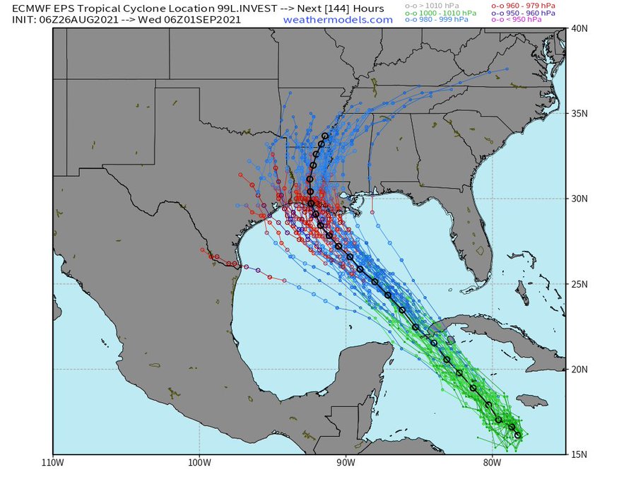
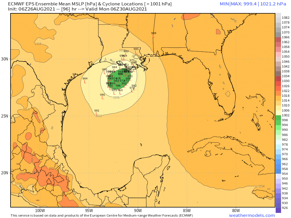
6z Euro with the shorter time range was very similar to the 0z. GFS is the outlier to the E. Enough spread on the ensembles that those especially around the golden triangle should continue to closely monitor.
-
Scott747
- Posts: 1648
- Joined: Tue Feb 23, 2010 9:56 am
- Location: Freeport/Surfside Beach
- Contact:
Digging further into the 6z Euro ensembles. This kind of chart certainly wouldn't make me totally comfortable quite yet along the upper Texas coast. No question the trend and threat has shifted E to Vermillion Bay and points e, but any subtle changes to ridging or the weakness created would have impacts even to the w. Likely at this point, no. But not off the table...
-
weatherguy425
- Pro Met
- Posts: 830
- Joined: Wed Feb 03, 2010 7:45 pm
- Location: Atlanta, Georgia
- Contact:
The whole southeast approach along fragile ridging is getting old; Laura, now this system.Scott747 wrote: ↑Thu Aug 26, 2021 9:10 am Digging further into the 6z Euro ensembles. This kind of chart certainly wouldn't make me totally comfortable quite yet along the upper Texas coast. No question the trend and threat has shifted E to Vermillion Bay and points e, but any subtle changes to ridging or the weakness created would have impacts even to the w. Likely at this point, no. But not off the table...
-
tireman4
- Global Moderator
- Posts: 7113
- Joined: Wed Feb 03, 2010 9:24 pm
- Location: Humble, Texas
- Contact:
Andy Hazelton Tweet This Morning
- Attachments
-
-
prospects8903
- Posts: 61
- Joined: Thu Aug 21, 2014 9:29 am
- Contact:
I’m located in Port Arthur…any thoughts on a chance for impact on my area?
-
srainhoutx

- Site Admin

- Posts: 19700
- Joined: Tue Feb 02, 2010 2:32 pm
- Location: Maggie Valley, NC
- Contact:
You are certainly not in the clear in Port Arthur. Keep very close tabs on the updates throughout the day into tomorrow. You should already have your personal Hurricane plan dusted off and I would definitely be making sure that supplies are replenished. I'm seeing way too many folks including some of the local Houston Mets sounding an all clear for the Upper Texas Coast.prospects8903 wrote: ↑Thu Aug 26, 2021 9:22 am I’m located in Port Arthur…any thoughts on a chance for impact on my area?
Carla/Alicia/Jerry(In The Eye)/Michelle/Charley/Ivan/Dennis/Katrina/Rita/Wilma/Humberto/Ike/Harvey
Member: National Weather Association
Facebook.com/Weather Infinity
Twitter @WeatherInfinity
Member: National Weather Association
Facebook.com/Weather Infinity
Twitter @WeatherInfinity
-
prospects8903
- Posts: 61
- Joined: Thu Aug 21, 2014 9:29 am
- Contact:
Thank you for the response
-
Cpv17
- Posts: 7077
- Joined: Fri Aug 31, 2018 1:58 pm
- Location: El Campo/Wharton
- Contact:
And this is why Louisiana is a tc magnet.weatherguy425 wrote: ↑Thu Aug 26, 2021 9:14 amThe whole southeast approach along fragile ridging is getting old; Laura, now this system.Scott747 wrote: ↑Thu Aug 26, 2021 9:10 am Digging further into the 6z Euro ensembles. This kind of chart certainly wouldn't make me totally comfortable quite yet along the upper Texas coast. No question the trend and threat has shifted E to Vermillion Bay and points e, but any subtle changes to ridging or the weakness created would have impacts even to the w. Likely at this point, no. But not off the table...
-
Scott747
- Posts: 1648
- Joined: Tue Feb 23, 2010 9:56 am
- Location: Freeport/Surfside Beach
- Contact:
Advisories will be initiated at 10. So we will at least get the first idea of potential track before recon,
-
cperk
- Posts: 857
- Joined: Sun Aug 19, 2012 12:09 pm
- Location: Richmond
- Contact:
Yeah srain I’m seeing that to and they should know better.srainhoutx wrote: ↑Thu Aug 26, 2021 9:29 amYou are certainly not in the clear in Port Arthur. Keep very close tabs on the updates throughout the day into tomorrow. You should already have your personal Hurricane plan dusted off and I would definitely be making sure that supplies are replenished. I'm seeing way too many folks including some of the local Houston Mets sounding an all clear for the Upper Texas Coast.prospects8903 wrote: ↑Thu Aug 26, 2021 9:22 am I’m located in Port Arthur…any thoughts on a chance for impact on my area?
-
tireman4
- Global Moderator
- Posts: 7113
- Joined: Wed Feb 03, 2010 9:24 pm
- Location: Humble, Texas
- Contact:
I echo Steve here. He has forgotten more about tropical systems ( and long range forecasts) than I know about anything weather related. Always be prudent. Make sure your supplies are stocked and checked. Make sure your generator is working ( test it out) and have gas for it. Go over your check list. It is always good to have it handy, no matter what the situation ( and as we experienced this past Winter, you might need it then too).srainhoutx wrote: ↑Thu Aug 26, 2021 9:29 amYou are certainly not in the clear in Port Arthur. Keep very close tabs on the updates throughout the day into tomorrow. You should already have your personal Hurricane plan dusted off and I would definitely be making sure that supplies are replenished. I'm seeing way too many folks including some of the local Houston Mets sounding an all clear for the Upper Texas Coast.prospects8903 wrote: ↑Thu Aug 26, 2021 9:22 am I’m located in Port Arthur…any thoughts on a chance for impact on my area?
-
Stratton20
- Posts: 5804
- Joined: Tue Feb 09, 2021 11:35 pm
- Location: College Station, Texas
- Contact:
Im not sure if this is how this works but since 99L is still moving WNW, if it takes longer to consolidate, would this have an effect on the track? Im 90% confident this is a Louisiana storm, but i still am not writing this off completely just like srainhoutx said,* nvm its already formed a LLC
Last edited by Stratton20 on Thu Aug 26, 2021 9:43 am, edited 1 time in total.
-
tireman4
- Global Moderator
- Posts: 7113
- Joined: Wed Feb 03, 2010 9:24 pm
- Location: Humble, Texas
- Contact:
Tropical Depression Number Nine
- Attachments
-
- TD 9 08 26 21.png (7.38 KiB) Viewed 4329 times