Page 62 of 70
Re: Hurricane Alex. 155 Miles E of La Pesca. 80 MPH/959 MB
Posted: Wed Jun 30, 2010 7:29 am
by Scott747
I don't know Ed. It literally stalled for a few hours last night and since resuming it almost looks to be a very slow NW heading. It appears there is at least in the short-term a much larger weakness that according to the disco they still expect to fill in.
7 am advisory kept it wnw @ 7 so I'll guess we will see if there really is any change at 10.
Re: Hurricane Alex. 155 Miles E of La Pesca. 80 MPH/959 MB
Posted: Wed Jun 30, 2010 7:33 am
by sleetstorm
Will southeast Texas be receiving any tropical storm force wind in those raind bands?
Re: Hurricane Alex. 155 Miles E of La Pesca. 80 MPH/959 MB
Posted: Wed Jun 30, 2010 7:34 am
by weatherguy425
I'm starting to question the ods of inland counties getting much rain, these bands really seem to be hugging the coast and with cloudy skies, idk how much will even develop?
Re: Hurricane Alex. 155 Miles E of La Pesca. 80 MPH/959 MB
Posted: Wed Jun 30, 2010 7:41 am
by srainhoutx
2 day QPF totals do keep heaviest rainfall near coastal counties...
Re: Hurricane Alex. 155 Miles E of La Pesca. 80 MPH/959 MB
Posted: Wed Jun 30, 2010 7:43 am
by srainhoutx
Product: Air Force Vortex Message (URNT12 KNHC)
Transmitted: 30th day of the month at 12:30Z
Aircraft: Air Force Aircraft (Last 3 digits of the tail number are 306)
Storm Number & Year: 01L in 2010
Storm Name: Alex (flight in the North Atlantic basin)
Mission Number: 11
Observation Number: 15
A. Time of Center Fix: 30th day of the month at 12:12:10Z
B. Center Fix Coordinates: 23°32'N 95°12'W (23.5333N 95.2W) (View map)
B. Center Fix Location: 219 miles (353 km) to the SE (139°) from Brownsville, TX, USA.
C. Minimum Height at Standard Level: 1,052m (3,451ft) at 850mb
D. Estimated (by SFMR or visually) Maximum Surface Wind: 56kts (~ 64.4mph)
E. Location of the Estimated Maximum Surface Wind: 8 nautical miles (9 statute miles) to the SW (217°) of center fix
F. Maximum Flight Level Wind Inbound: From 300° at 62kts (From the WNW at ~ 71.3mph)
G. Location of Maximum Flight Level Wind Inbound: 8 nautical miles (9 statute miles) to the SW (217°) of center fix
H. Minimum Sea Level Pressure: 958mb (28.29 inHg)
I. Maximum Flight Level Temp & Pressure Altitude Outside Eye: 20°C (68°F) at a pressure alt. of 1,525m (5,003ft)
J. Maximum Flight Level Temp & Pressure Altitude Inside Eye: 22°C (72°F) at a pressure alt. of 1,520m (4,987ft)
K. Dewpoint Temp (collected at same location as temp inside eye): 19°C (66°F)
K. Sea Surface Temp (collected at same location as temp inside eye): Not Available
L. Eye Character: Open in the northwest
M. Eye Shape & Diameter: Circular with a diameter of 9 nautical miles
N. Fix Determined By: Penetration, Radar, Wind, Pressure and Temperature
N. Fix Level: 850mb
O. Navigation Fix Accuracy: 0.02 nautical miles
O. Meteorological Accuracy: 1 nautical mile
Remarks Section:
Maximum Flight Level Wind: 88kts (~ 101.3mph) in the northeast quadrant at 12:16:30Z
Maximum Flight Level Wind Outbound: 88kts (~ 101.3mph) in the northeast quadrant at 12:16:30Z
Maximum Wind Outbound: 88kts (~ 101.3mph) in the northeast quadrant at 12:16:30Z
Maximum Flight Level Wind: 88kts (~ 101.3mph) in the northeast quadrant at 12:16:30Z
Re: Hurricane Alex. 155 Miles E of La Pesca. 80 MPH/959 MB
Posted: Wed Jun 30, 2010 8:11 am
by Hardcoreweather
8am a wobble watch warning has been issued for KHOU.com and is in effect until 10pm tonight. You can expect many posters saying it's going one way when it's really going another. Forecaster Kinkaid
Re: Hurricane Alex. 155 Miles E of La Pesca. 80 MPH/959 MB
Posted: Wed Jun 30, 2010 8:15 am
by srainhoutx
Latest...
06302010_1255_GULF_vis.jpg
Re: Hurricane Alex. 155 Miles E of La Pesca. 80 MPH/959 MB
Posted: Wed Jun 30, 2010 8:22 am
by ronyan
Wow I see that Alex's pressure tanked a little earlier this morning. He dropped from 972 to 959 mb and the winds are still only 80 mph?

It appears he had a better defined eye feature a couple hours ago, maybe he's replacing it now. He's still taking his sweet time though.

Re: Hurricane Alex. 155 Miles E of La Pesca. 80 MPH/959 MB
Posted: Wed Jun 30, 2010 8:31 am
by srainhoutx
NW motion evident via Brownsville long range radar. RECON reports rather strong flight level winds well to the NE of the center.
Re: Hurricane Alex. 155 Miles E of La Pesca. 80 MPH/959 MB
Posted: Wed Jun 30, 2010 8:41 am
by Snowman
looks like alex had one more trick up his sleeve. this storm has been elusive just when we think we got it he stalls out and moves north.
i am very concerned about a possible lack of rainfall! i thought a coastal trough was going to help provide all of our lawns with rain. i live in northwest harris county will the rain even make it that far up?
Re: Hurricane Alex. 155 Miles E of La Pesca. 80 MPH/959 MB
Posted: Wed Jun 30, 2010 8:51 am
by ronyan
Snowman wrote:looks like alex had one more trick up his sleeve. this storm has been elusive just when we think we got it he stalls out and moves north.
i am very concerned about a possible lack of rainfall! i thought a coastal trough was going to help provide all of our lawns with rain. i live in northwest harris county will the rain even make it that far up?
Yeah I was pretty sure that it would be raining by now here in Clear Lake.

I really hope we get at least an inch or two.
Re: Hurricane Alex. 155 Miles E of La Pesca. 80 MPH/959 MB
Posted: Wed Jun 30, 2010 9:13 am
by Rip76
Still not sold on this being a rainmaker.... No matter what the values are showing.
This has been one interesting storm.
I was thinking about people tracking hurricanes pre-internet, and how it must have felt just "waiting" for the next news update.
Sort of like we did with Alicia. I remember the anticipation.
Re: Hurricane Alex. 155 Miles E of La Pesca. 80 MPH/959 MB
Posted: Wed Jun 30, 2010 9:14 am
by Hardcoreweather
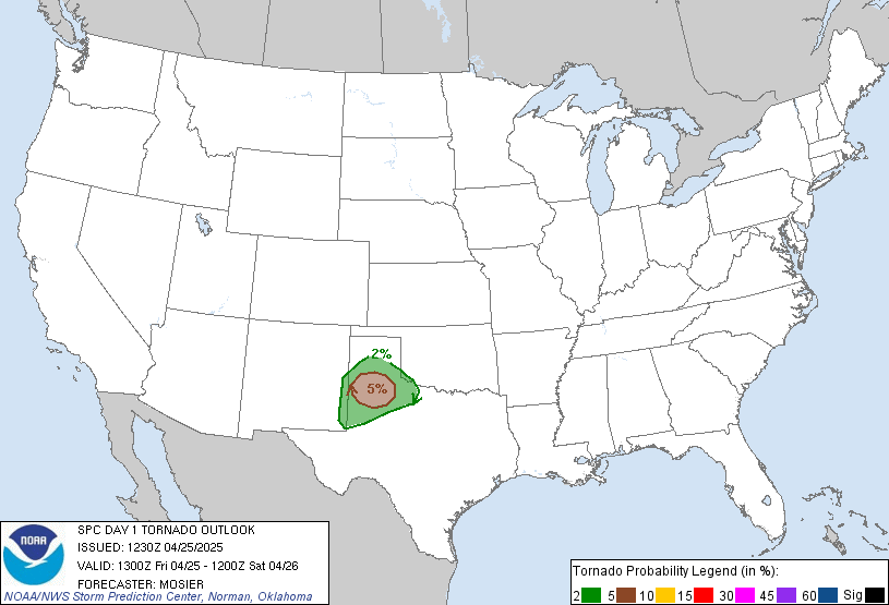
SPC

DEEP S TX...
BASED ON LATEST NHC GUIDANCE...HURRICANE ALEX IS FORECAST TO
CONTINUE A WNWWD TRACK...MAKING LANDFALL ALONG THE NERN COAST OF
MEXICO TONIGHT. TIME TRENDS FROM BRO VWP INDICATE THAT LOW-LEVEL
SHEAR HAS STRENGTHENED CONSIDERABLY THIS MORNING WITH THE APPROACH
OF THE TROPICAL CYCLONE...AND THIS TREND WILL LIKELY CONTINUE
THROUGH THE REMAINDER OF THE DAY. AS WOULD BE EXPECTED...AMBIENT
AIR MASS IS VERY MOIST WITH PW VALUES APPROACHING 2.80 INCHES. AND
WHILE WIDESPREAD CLOUDINESS WILL LIMIT THE DEGREE OF DIABATIC
HEATING...THE HIGH MOISTURE CONTENT WILL MAINTAIN MODERATE
INSTABILITY WITH MLCAPE OF 1000-1500 J/KG.
CURRENT THINKING IS THAT THE THREAT FOR A FEW TORNADOES WILL
INCREASE THROUGH THE DAY...PEAKING THIS AFTERNOON INTO EVENING...IN
ASSOCIATION WITH ANY MORE PERSISTENT...ROTATING STORMS EMBEDDED
WITHIN LANDFALLING RAINBANDS.
Re: Hurricane Alex. 155 Miles E of La Pesca. 80 MPH/959 MB
Posted: Wed Jun 30, 2010 9:15 am
by Bluefalcon
Recon is about to fix the center, Vortex will follow.
Re: Hurricane Alex. 155 Miles E of La Pesca. 80 MPH/959 MB
Posted: Wed Jun 30, 2010 9:17 am
by Bluefalcon
Re: Hurricane Alex. 155 Miles E of La Pesca. 80 MPH/959 MB
Posted: Wed Jun 30, 2010 9:20 am
by ticka1
Any links to webcams down in corpus or brownsville?
Re: Hurricane Alex. 155 Miles E of La Pesca. 80 MPH/959 MB
Posted: Wed Jun 30, 2010 9:28 am
by srainhoutx
Re: Hurricane Alex. 155 Miles E of La Pesca. 80 MPH/959 MB
Posted: Wed Jun 30, 2010 9:33 am
by srainhoutx
Re: Hurricane Alex. 155 Miles E of La Pesca. 80 MPH/959 MB
Posted: Wed Jun 30, 2010 9:34 am
by Bluefalcon
Recon just fixed the center. 960.1 mb. Center is a little more west of north than the last fix and a little faster.
Re: Hurricane Alex. 155 Miles E of La Pesca. 80 MPH/959 MB
Posted: Wed Jun 30, 2010 9:35 am
by srainhoutx
Product: Air Force Vortex Message (URNT12 KNHC)
Transmitted: 30th day of the month at 14:32Z
Aircraft: Air Force Aircraft (Last 3 digits of the tail number are 306)
Storm Number & Year: 01L in 2010
Storm Name: Alex (flight in the North Atlantic basin)
Mission Number: 11
Observation Number: 20
A. Time of Center Fix: 30th day of the month at 14:05:40Z
B. Center Fix Coordinates: 23°49'N 95°26'W (23.8167N 95.4333W)
B. Center Fix Location: 195 miles (313 km) to the SE (139°) from Brownsville, TX, USA.
C. Minimum Height at Standard Level: 1,063m (3,488ft) at 850mb
D. Estimated (by SFMR or visually) Maximum Surface Wind: 54kts (~ 62.1mph)
E. Location of the Estimated Maximum Surface Wind: 10 nautical miles (12 statute miles) to the WNW (300°) of center fix
F. Maximum Flight Level Wind Inbound: From 52° at 62kts (From the NE at ~ 71.3mph)
G. Location of Maximum Flight Level Wind Inbound: 15 nautical miles (17 statute miles) to the NW (304°) of center fix
H. Minimum Sea Level Pressure: 961mb (28.38 inHg)
I. Maximum Flight Level Temp & Pressure Altitude Outside Eye: 20°C (68°F) at a pressure alt. of 1,522m (4,993ft)
J. Maximum Flight Level Temp & Pressure Altitude Inside Eye: 24°C (75°F) at a pressure alt. of 1,523m (4,997ft)
K. Dewpoint Temp (collected at same location as temp inside eye): 20°C (68°F)
K. Sea Surface Temp (collected at same location as temp inside eye): Not Available
L. Eye Character: Not Available
M. Eye Shape: Not Available
N. Fix Determined By: Penetration, Radar, Wind, Pressure and Temperature
N. Fix Level: 850mb
O. Navigation Fix Accuracy: 0.02 nautical miles
O. Meteorological Accuracy: 1 nautical mile
Remarks Section:
Maximum Flight Level Wind: 89kts (~ 102.4mph) in the northeast quadrant at 14:19:10Z
Maximum Flight Level Wind Outbound: 89kts (~ 102.4mph) in the northeast quadrant at 14:19:10Z
Maximum Wind Outbound: 89kts (~ 102.4mph) in the northeast quadrant at 14:19:10Z
Maximum Flight Level Wind: 89kts (~ 102.4mph) in the northeast quadrant at 14:19:10Z

