
October 2015 - Severe Storms/Moderate Risk Excessive Rainfal
-
Katdaddy

- Global Moderator

- Posts: 2521
- Joined: Thu Feb 04, 2010 8:18 am
- Location: League City, Tx
- Contact:
As Srain noted, showers have already develop off the Upper TX Coast this morning. This is just a sign of things to come. Busy weather day's ahead and we will do our best to keep everyone informed through the weekend.
- Attachments
-
- Screen Shot 2015-10-20 at 5.30.41 AM.png (122.17 KiB) Viewed 6634 times
-
srainhoutx

- Site Admin

- Posts: 19700
- Joined: Tue Feb 02, 2010 2:32 pm
- Location: Maggie Valley, NC
- Contact:
Morning briefing from Jeff:
Area will go from drought and fires to heavy rainfall and flooding over the next 5 days.
Large scale pattern change is underway this morning with a deep layer trough starting to move into the SW US. This trough will slow down and begin to pull the mass of deep tropical moisture to our south northward later today and Wednesday. Tropical cyclone formation is likely on the west side of the Mexican coast which will then track NW into the MX coast later this week spreading additional mid and high level moisture northward toward TX. Deep layer low to our west by late week will help to foster a strong coastal trough over the western Gulf of Mexico from offshore of S TX to inland of Matagorda Bay. Moisture levels surge to very impressive levels for late October with PWS of 2.4-2.6 inches likely over much of the region by late Friday into Saturday.
Moisture is already increasing this morning with showers offshore of Galveston and expect the onshore flow to continue to pump moisture into the region today and Wednesday. Rainfall will be scattered at best the next 24-36 hours with significant increase expected on Thursday as strong upper level dynamics ejects into the region from the west and the coastal trough forms along the coast.
Prolonged heavy rainfall event should unfold Friday into late Saturday as strong southerly flow and south to north orientation of the coastal trough leads to sustained cell training of bands over the region. Rainfall rates will greatly increase as moisture levels increase and 2-3 inches per hour will certainly be possible. Models have been really pegging the Matagorda Bay area northward toward College Station the last few runs for a fairly significant band of heavy rainfall. Too early to define specific area that may see the most…but the model agreement is pretty good.
Will go with widespread 2-4 inches across the entire region with isolated totals of 6 inches or greater. Would not be surprised to see a couple of locations with 10 inches or greater.
Tides:
Other aspect will be higher than normal tides. Tides are already running 1-2 ft above normal and this will continue through the end of the week as ENE to ESE winds continue across the entire northern Gulf. Combined effects of wave run-up on the beaches and water transport to the right of the mean wind flow (Ekman transport) support above average tides. Areas just SW of Matagorda Bay have been having some issues at high tide the last few cycles and a coastal flood advisory may be needed from Calhoun County south to near Corpus Christi.
Fire Weather:
Should see vast improvement in the battle against wildfires across the state over the next 24 hours as significant RH recovery is expected today. While fuels will remain very dry…higher RH should help prevent as many fire starts as seen the last few days. Significant rain chances develop over the region Thursday with widespread wetting rainfall expected and this will end the wildfire threat.
Wildfire Activity (Last 7 days):
Carla/Alicia/Jerry(In The Eye)/Michelle/Charley/Ivan/Dennis/Katrina/Rita/Wilma/Humberto/Ike/Harvey
Member: National Weather Association
Facebook.com/Weather Infinity
Twitter @WeatherInfinity
Member: National Weather Association
Facebook.com/Weather Infinity
Twitter @WeatherInfinity
-
srainhoutx
- Site Admin
- Posts: 19700
- Joined: Tue Feb 02, 2010 2:32 pm
- Location: Maggie Valley, NC
- Contact:
It looks like a tropical depression has formed in the Gulf of Tehuantepec. Its name will be Patricia if it becomes a named storm.

- Attachments
-
- 10202015_1230_goes13_x_ir1km_97EINVEST_30kts-1007mb-133N-933W_95pc.jpg (44.99 KiB) Viewed 6558 times
Carla/Alicia/Jerry(In The Eye)/Michelle/Charley/Ivan/Dennis/Katrina/Rita/Wilma/Humberto/Ike/Harvey
Member: National Weather Association
Facebook.com/Weather Infinity
Twitter @WeatherInfinity
Member: National Weather Association
Facebook.com/Weather Infinity
Twitter @WeatherInfinity
-
ticka1
- Posts: 1265
- Joined: Wed Feb 03, 2010 3:02 pm
- Location: Baytown/Mont Belvieu
- Contact:
Wow that's my real name Patricia LOL!!! Let's hope it just stays a depression!!
-
srainhoutx
- Site Admin
- Posts: 19700
- Joined: Tue Feb 02, 2010 2:32 pm
- Location: Maggie Valley, NC
- Contact:
Tropical Depression 20E forms near the Gulf of Tehuantepec in the Eastern Pacific. Also included are the 12Z Track and Intensity guidance for this tropical cyclone as it will be one of several 'players' in our potential heavy rainfall event expect later this week.
TROPICAL DEPRESSION TWENTY-E DISCUSSION NUMBER 1
NWS NATIONAL HURRICANE CENTER MIAMI FL EP202015
1000 AM CDT TUE OCT 20 2015
Satellite data indicate that deep convection associated with the
area of low pressure a few hundred miles southeast of Puerto
Escondido, Mexico, has become sufficiently well organized to
designate the system as a tropical depression. The circulation of
the low has also become better defined according to an overnight
ASCAT pass, though it could still be somewhat elongated to the
south. The depression's cloud pattern is characterized by
interlocking convective bands, with the estimated low-level center
underneath the eastward tip of the western band. A Dvorak intensity
estimate of T2.0 from TAFB is used to set the initial intensity at
30 kt.
Since the center location uncertainty has been high until
very recently, the initial motion estimate is a rather uncertain
280/02. The track guidance is in very good agreement that a
mid-level ridge over the Gulf of Mexico with an east-northeast to
west-northwest orientation should impart a west-southwestward motion
for about 24 hours. A turn toward the west and west-northwest
with some increase in forward speed is forecast by 36 hours once the
ridge over the Gulf of Mexico shifts eastward. When the cyclone
reaches the western edge of ridge around 72 hours, it should turn
northwestward. The evolution of a deep longwave trough over the
southwestern U.S. and northwestern Mexico is of critical
importance to the track forecast after that time as the cyclone
nears the southwestern coast of Mexico. There are differences
between the models regarding the timing and strength of a shortwave
trough dropping into the southwestern U. S. during this period,
resulting in increasing spread of the track guidance after 72
hours. The track forecast is close to the multi-model consensus,
but it is a little west of the GFS and ECMWF solutions beyond day 3.
The large-scale environment around the cyclone is forecast to be
quite conducive for intensification during the next few days, with
SSTs to above 30 deg C, a rich moisture supply in the lower to
middle troposphere, and very light vertical shear. The main
limiting factor should be how quickly the cyclone develops enough
inner-core organization to potentially rapidly intensify. Prior to
landfall, an increase in southwesterly vertical shear and drier air
associated with the mid-to upper-level trough to the northwest could
result in weakening, with a peak intensity mostly likely between the
72- and 96-hour points. The NHC intensity forecast is above the
multi-model consensus and in best agreement with the LGEM output
until the forecast landfall. Dissipation is shown after 96 hours,
though it could occur sooner over the high terrain of the Sierra
Madre Occidental.
FORECAST POSITIONS AND MAX WINDS
INIT 20/1500Z 13.3N 94.4W 30 KT 35 MPH
12H 21/0000Z 13.0N 95.5W 35 KT 40 MPH
24H 21/1200Z 12.8N 97.0W 45 KT 50 MPH
36H 22/0000Z 12.9N 98.9W 55 KT 65 MPH
48H 22/1200Z 13.9N 101.0W 70 KT 80 MPH
72H 23/1200Z 16.3N 103.7W 85 KT 100 MPH
96H 24/1200Z 20.5N 104.4W 50 KT 60 MPH...INLAND
120H 25/1200Z...DISSIPATED
$$
Forecaster Kimberlain
Carla/Alicia/Jerry(In The Eye)/Michelle/Charley/Ivan/Dennis/Katrina/Rita/Wilma/Humberto/Ike/Harvey
Member: National Weather Association
Facebook.com/Weather Infinity
Twitter @WeatherInfinity
Member: National Weather Association
Facebook.com/Weather Infinity
Twitter @WeatherInfinity
-
Electric Lizard
- Posts: 53
- Joined: Sat May 24, 2014 7:37 am
- Contact:
Now that a TD has formed in the Gulf of Tuhanapec, will it cause the system in the Gulf of Honduras to lose strength?
-
srainhoutx
- Site Admin
- Posts: 19700
- Joined: Tue Feb 02, 2010 2:32 pm
- Location: Maggie Valley, NC
- Contact:
There is still abundant tropical moisture left in the NW Caribbean Sea and it is beginning to increase across the Western Gulf as the deep longwave trough pulls the moisture N. 92L is not going to develop, but the outcome is still the same regarding our potential sensible weather expected later in the week into the weekend. The unknowns are just how slow the Western trough finally decides to fully eject into the Plains as well as several mid/upper level embedded disturbance moving NE around the base of the trough and potential Hurricane Patricia as it make landfall along the Western Mexico Coast. Then add to the mix the strength of the Coastal trough/low which will further enhance rainfall chances along the Texas and Louisiana Coast. There are a lot of players to watch the next several days as we head toward this very active weather pattern. Also it is worth mentioning that a very strong cold shot may develop late in October as Typhoon Champi recurves across the Northern Pacific and reshuffles the entire upper air pattern across North America.Electric Lizard wrote:Now that a TD has formed in the Gulf of Tuhanapec, will it cause the system in the Gulf of Honduras to lose strength?
Carla/Alicia/Jerry(In The Eye)/Michelle/Charley/Ivan/Dennis/Katrina/Rita/Wilma/Humberto/Ike/Harvey
Member: National Weather Association
Facebook.com/Weather Infinity
Twitter @WeatherInfinity
Member: National Weather Association
Facebook.com/Weather Infinity
Twitter @WeatherInfinity
-
unome
- Posts: 3062
- Joined: Fri Feb 12, 2010 6:11 pm
there has not been a "system" in the Gulf of Honduras. there is an area highlighted by NHC with 10% chance of development in 5 days, but there isn't currently an Atlantic invest on the ftp site, they quit updating 92L 12Z on the 18th: ftp://ftp.nhc.noaa.gov/atcf/btk/
the current hazardous weather outlook from HGX: http://forecast.weather.gov/product.php ... roduct=HWO
.DAYS TWO THROUGH SEVEN...WEDNESDAY THROUGH MONDAY
HEAVY RAINFALL IS POSSIBLE THURSDAY THROUGH EARLY SUNDAY AS AN UPPER
LEVEL STORM SYSTEM TO THE WEST INTERACTS WITH A DEVELOPING STORM SYSTEM
ALONG THE COAST. RAINFALL TOTALS COULD POSSIBLY REACH OR EXCEED 1 TO
3 INCHES GENERALLY ALONG AND NORTH OF A LINE FROM LIBERTY TO CONROE
TO THE BRYAN COLLEGE STATION AREA...AND COULD POSSIBLY REACH OR EXCEED
3 TO 5 INCHES SOUTH OF THAT LINE. FLASH FLOOD WATCHES MIGHT BE NEEDED.
STRONG RIP CURRENTS ARE POSSIBLE ALONG THE COAST TONIGHT THROUGH
SUNDAY...WHILE ELEVATED TIDE LEVELS ARE EXPECTED THROUGH MONDAY.
POSSIBLE COASTAL FLOODING WILL DEPEND ON THE LOCATION AND STRENGTH
OF THE COASTAL STORM SYSTEM.
.SPOTTER INFORMATION STATEMENT...
SPOTTER ACTIVATION MIGHT BE NEEDED THURSDAY THROUGH SUNDAY MORNING.
Twitter & Facebook posts
https://twitter.com/NWSHouston/status/6 ... 3777665024
https://www.facebook.com/NWSHouston/pho ... =3&theater
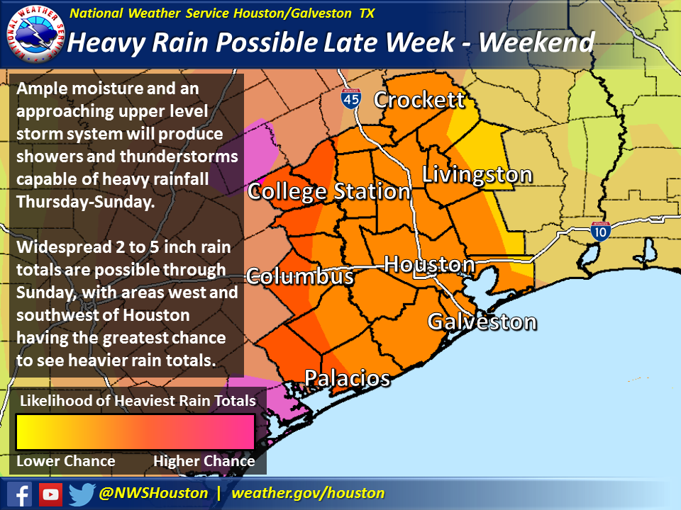
Showers and thunderstorms capable of heavy rainfall will be possible from late this week into the weekend, with widespread totals of 2 to 5 inches possible. The areas with the greatest chance to see heavier rain totals are west and southwest of the Houston metro.
the current hazardous weather outlook from HGX: http://forecast.weather.gov/product.php ... roduct=HWO
.DAYS TWO THROUGH SEVEN...WEDNESDAY THROUGH MONDAY
HEAVY RAINFALL IS POSSIBLE THURSDAY THROUGH EARLY SUNDAY AS AN UPPER
LEVEL STORM SYSTEM TO THE WEST INTERACTS WITH A DEVELOPING STORM SYSTEM
ALONG THE COAST. RAINFALL TOTALS COULD POSSIBLY REACH OR EXCEED 1 TO
3 INCHES GENERALLY ALONG AND NORTH OF A LINE FROM LIBERTY TO CONROE
TO THE BRYAN COLLEGE STATION AREA...AND COULD POSSIBLY REACH OR EXCEED
3 TO 5 INCHES SOUTH OF THAT LINE. FLASH FLOOD WATCHES MIGHT BE NEEDED.
STRONG RIP CURRENTS ARE POSSIBLE ALONG THE COAST TONIGHT THROUGH
SUNDAY...WHILE ELEVATED TIDE LEVELS ARE EXPECTED THROUGH MONDAY.
POSSIBLE COASTAL FLOODING WILL DEPEND ON THE LOCATION AND STRENGTH
OF THE COASTAL STORM SYSTEM.
.SPOTTER INFORMATION STATEMENT...
SPOTTER ACTIVATION MIGHT BE NEEDED THURSDAY THROUGH SUNDAY MORNING.
Twitter & Facebook posts
https://twitter.com/NWSHouston/status/6 ... 3777665024
https://www.facebook.com/NWSHouston/pho ... =3&theater
Showers and thunderstorms capable of heavy rainfall will be possible from late this week into the weekend, with widespread totals of 2 to 5 inches possible. The areas with the greatest chance to see heavier rain totals are west and southwest of the Houston metro.
-
srainhoutx
- Site Admin
- Posts: 19700
- Joined: Tue Feb 02, 2010 2:32 pm
- Location: Maggie Valley, NC
- Contact:
Reconnaissance Missions have been tasked for future Patricia in the Eastern Pacific that include 2 high altitude aircraft. The G-IV as well as WB-57 (Retrofitted U-2 Spy Very High Altitude Aircraft) will be involved in the missions. These will likely assist the computer guidance in the future forecasts regarding our heavy rainfall event.
Code: Select all
WEATHER RECONNAISSANCE FLIGHTS
CARCAH, NATIONAL HURRICANE CENTER, MIAMI, FL.
1100 AM EDT TUE 20 OCTOBER 2015
SUBJECT: TROPICAL CYCLONE PLAN OF THE DAY (TCPOD)
         VALID 21/1100Z TO 22/1100Z OCTOBER 2015
         TCPOD NUMBER.....15-147

II. PACIFIC REQUIREMENTS
    1. TROPICAL DEPRESSION 20E

       FLIGHT ONE -- NOAA 43
       A. 21/1800Z
       B. NOAA3 0120E CYCLONE
       C. 21/1430Z
       D. 12.9N 98.0W
       E. 21/1730Z TO 21/2000Z
       F. SFC TO 10,000 FT.

    2. SUCCEEDING DAY OUTLOOK: A FIX AT 22/1800Z NEAR 14.5 101.7W
    3. ADDITIONAL DAY OUTLOOK: POSSIBLE G-IV SYNOPTIC SURVEILLANCE
       MISSION FOR HURRICANE OLAF AT 23/1730Z IN CENTRAL PACIFIC.
    4. REMARKS: NOAA WB-57 IS FLYING A 5.5 HOUR RESEARCH MISSION
       AROUND THE SUSPECT AREA TODAY WITH A 20/1600Z TAKEOFF FROM
       HARLINGEN. FLIGHT LEVELS 55,000 TO 65,000FT. DROPS: 80
       ANTICIPATED. TOMORROW'S TAKEOFF 21/1500Z INTO THE SAME
       AREA WITH 54 DROPS ANTICIPATED.
Carla/Alicia/Jerry(In The Eye)/Michelle/Charley/Ivan/Dennis/Katrina/Rita/Wilma/Humberto/Ike/Harvey
Member: National Weather Association
Facebook.com/Weather Infinity
Twitter @WeatherInfinity
Member: National Weather Association
Facebook.com/Weather Infinity
Twitter @WeatherInfinity
-
brooksgarner

- Global Moderator
- Posts: 226
- Joined: Tue Jun 04, 2013 3:06 pm
- Location: Houston, TX
- Contact:
Looking like the heaviest axis of moisture will swing through Sunday... This is an especially complicated setup considering the high-impact potential, but when is it not complicated, right?
There is model agreement of heavy rain potential, but the track of future Patricia in the Pacific will help determine if this heaviest rain falls in the Hill Country or around Houston.
Tune in for the Noon update...
There is model agreement of heavy rain potential, but the track of future Patricia in the Pacific will help determine if this heaviest rain falls in the Hill Country or around Houston.
Tune in for the Noon update...
Broadcast Met
http://BrooksGarner.com
http://twitter.com/BrooksWeather
http://BrooksGarner.com
http://twitter.com/BrooksWeather
- '17 Harvey
- '12 Sandy (P3 Orion)
- '91 Bob
- '85 Gloria
-
unome
- Posts: 3062
- Joined: Fri Feb 12, 2010 6:11 pm
NHC's TWO at 2 now has a 0% chance for 2 and 5 days for their yellow X
http://www.nhc.noaa.gov/text/refresh/MI ... WOAT.shtml
but, the most recent surface forecast shows a low in the BOC on 24 & 48 hrs, gone by 72
http://www.nhc.noaa.gov/tafb_latest/atl ... BW_sm3.gif
http://www.nhc.noaa.gov/tafb_latest/atl ... BW_sm3.gif
http://www.nhc.noaa.gov/tafb_latest/atl ... BW_sm3.gif
-
srainhoutx
- Site Admin
- Posts: 19700
- Joined: Tue Feb 02, 2010 2:32 pm
- Location: Maggie Valley, NC
- Contact:
The afternoon Update from the Weather Prediction Center continues to march the Moderate and Slight Risk for Excessive Rainfall E across portions of Texas and Oklahoma. These are valid for Wednesday through Thursday night/early morning Friday.
- Attachments
-
Carla/Alicia/Jerry(In The Eye)/Michelle/Charley/Ivan/Dennis/Katrina/Rita/Wilma/Humberto/Ike/Harvey
Member: National Weather Association
Facebook.com/Weather Infinity
Twitter @WeatherInfinity
Member: National Weather Association
Facebook.com/Weather Infinity
Twitter @WeatherInfinity
-
srainhoutx
- Site Admin
- Posts: 19700
- Joined: Tue Feb 02, 2010 2:32 pm
- Location: Maggie Valley, NC
- Contact:
Here are the afternoon Updated QPF Forecasts for Day 3, Day 4 to 5, and Day 6 to 7...
- Attachments
-
-
-
Carla/Alicia/Jerry(In The Eye)/Michelle/Charley/Ivan/Dennis/Katrina/Rita/Wilma/Humberto/Ike/Harvey
Member: National Weather Association
Facebook.com/Weather Infinity
Twitter @WeatherInfinity
Member: National Weather Association
Facebook.com/Weather Infinity
Twitter @WeatherInfinity
-
srainhoutx
- Site Admin
- Posts: 19700
- Joined: Tue Feb 02, 2010 2:32 pm
- Location: Maggie Valley, NC
- Contact:
Impressive moisture plume from future Patricia in the Eastern Pacific spreading across Texas/Oklahoma and Louisiana via the 12Z GEFS individual ensemble members.
- Attachments
-
Carla/Alicia/Jerry(In The Eye)/Michelle/Charley/Ivan/Dennis/Katrina/Rita/Wilma/Humberto/Ike/Harvey
Member: National Weather Association
Facebook.com/Weather Infinity
Twitter @WeatherInfinity
Member: National Weather Association
Facebook.com/Weather Infinity
Twitter @WeatherInfinity
-
srainhoutx
- Site Admin
- Posts: 19700
- Joined: Tue Feb 02, 2010 2:32 pm
- Location: Maggie Valley, NC
- Contact:
Afternoon Updated QPF totals for the next 7 days from the Weather Prediction Center.
- Attachments
-
Carla/Alicia/Jerry(In The Eye)/Michelle/Charley/Ivan/Dennis/Katrina/Rita/Wilma/Humberto/Ike/Harvey
Member: National Weather Association
Facebook.com/Weather Infinity
Twitter @WeatherInfinity
Member: National Weather Association
Facebook.com/Weather Infinity
Twitter @WeatherInfinity
-
unome
- Posts: 3062
- Joined: Fri Feb 12, 2010 6:11 pm
WPC's QPF discussion, updated 4:37 EDT, entire disco at the link, here's a piece (in lower case, cuz Iall caps gives me a headache)
http://www.wpc.ncep.noaa.gov/discussion ... isc=qpfpfd
...southwest/great basin/southern and central rockies/plains...
closed upper-level low over the southwest will be kicked out by another short wave off the northwest coast that will eject the closed low northeastward to the northern plains/upper mississippi valley by friday evening. the upper-level low will open by thursday evening. the short wave off the northwest coast will move southeastward to the southwest by friday evening. strong flow off the western gulf of mexico will stream moisture with precipitable water values of 1.75 inches on wednesday evening increasing to 2.00 inches by thursday morning. low-level flow of 60 to 45 knots will pull moisture with precipitable water values of 1.50 inches into the central plains by thursday evening with the axis of moisture moving into the middle mississippi valley by friday evening. qpf amounts of 1.50 to 5.00 inches is forecast for the texas panhandle on wednesday into thursday with maximum qpf becoming 1.50 to 3.00 plus inches over parts of north-central texas into central oklahoma thursday into friday. wpc move the western edge of the qpf slightly farther east with this package. in addition ... wpc followed a blend of the ecmwf and in-house-pseudo bias corrected as a starting point for the manual qpf.
with heavy precipitation over the southern rockies and southern high plains on wednesday and continued over the southern high plains on thursday wpc issued a slight with an embedded moderate risk of excessive rainfall over the texas panhandle from wednesday morning into thursday morning. likewise ... with the axis of heavy rain moving eastward wpc issued a slight with an embedded moderate risk of excessive rainfall over north-central texas into central oklahoma from thursday morning into friday morning.
-
Paul Robison
Will TS Patricia cross over into the GOMEX, become a hurricane, and threaten SE TX?
-
srainhoutx
- Site Admin
- Posts: 19700
- Joined: Tue Feb 02, 2010 2:32 pm
- Location: Maggie Valley, NC
- Contact:
Nope.Paul Robison wrote:Will TS Patricia cross over into the GOMEX, become a hurricane, and threaten SE TX?
Carla/Alicia/Jerry(In The Eye)/Michelle/Charley/Ivan/Dennis/Katrina/Rita/Wilma/Humberto/Ike/Harvey
Member: National Weather Association
Facebook.com/Weather Infinity
Twitter @WeatherInfinity
Member: National Weather Association
Facebook.com/Weather Infinity
Twitter @WeatherInfinity
-
srainhoutx
- Site Admin
- Posts: 19700
- Joined: Tue Feb 02, 2010 2:32 pm
- Location: Maggie Valley, NC
- Contact:
Evening briefing from Jeff:
Long fetch easterly winds of 15-20kts between high pressure over the SE US and low pressure over the southern Gulf of Mexico is resulting in elevated tides along the upper TX coast. Last high tide this afternoon resulted in coastal overwash on HWY 87 at HWY 124 at the east end of Bolivar. High tide within Galveston Bay peaked at 3.2 ft at Shoreacres and 3.1 ft at Seabrook. The 3.2ft at Shoreacres is only about .5 ft below flooding threshold when both east and west Bayou Dr south of Shoreacres Dr becomes flooded with sea water. Flooding thresholds around Clear Lake are around 4.5 ft or about 1.5 ft higher than the high tide today.
Not expecting much of an increase in the persistent easterly wind over the next few days which will continue to produce elevated tides of 1-2 feet above normal. Wave heights at the buoy 20NM east of Galveston have actually fallen from around 7ft this morning to around 4.5 ft this evening. High wave action this morning may have helped to add a little run-up on the Gulf beach front resulting in some of the overwash. Maximum water level expected to peak at 2.5 ft above MSL at Galveston Pleasure Pier tomorrow afternoon/evening which will be about .5 ft higher than today. This could result in some coastal flooding around Shoreacres and the Galveston Bay side of Seabrook (Toodville Rd area) as well as the west bound approach to the Lynchburg Ferry Landing during high tide.
Water Level Plot of HCFCD Gage 610 (Shoreacres) from the midday high tide:
Forecasted Total Water Level plots for Galveston Pleasure Pier:
Formation of TD 20-E off the Mexican coast this afternoon and forecast to become a category 2 hurricane and landfall along the west Mexican coast late this week will likely play a part in the upcoming rainfall event over TX. It is likely that mid and high level moisture from this tropical system will become entrained into the deep upper level trough digging into the SW US and will be drawn NNE to NE into TX this weekend. In fact some of the guidance shows the upper level vort associated with the system being drawn toward coastal TX by late Saturday into Sunday.
[/i]
Long fetch easterly winds of 15-20kts between high pressure over the SE US and low pressure over the southern Gulf of Mexico is resulting in elevated tides along the upper TX coast. Last high tide this afternoon resulted in coastal overwash on HWY 87 at HWY 124 at the east end of Bolivar. High tide within Galveston Bay peaked at 3.2 ft at Shoreacres and 3.1 ft at Seabrook. The 3.2ft at Shoreacres is only about .5 ft below flooding threshold when both east and west Bayou Dr south of Shoreacres Dr becomes flooded with sea water. Flooding thresholds around Clear Lake are around 4.5 ft or about 1.5 ft higher than the high tide today.
Not expecting much of an increase in the persistent easterly wind over the next few days which will continue to produce elevated tides of 1-2 feet above normal. Wave heights at the buoy 20NM east of Galveston have actually fallen from around 7ft this morning to around 4.5 ft this evening. High wave action this morning may have helped to add a little run-up on the Gulf beach front resulting in some of the overwash. Maximum water level expected to peak at 2.5 ft above MSL at Galveston Pleasure Pier tomorrow afternoon/evening which will be about .5 ft higher than today. This could result in some coastal flooding around Shoreacres and the Galveston Bay side of Seabrook (Toodville Rd area) as well as the west bound approach to the Lynchburg Ferry Landing during high tide.
Water Level Plot of HCFCD Gage 610 (Shoreacres) from the midday high tide:
- 10202015 Jeff 5 unnamed.gif (33.69 KiB) Viewed 5833 times
Carla/Alicia/Jerry(In The Eye)/Michelle/Charley/Ivan/Dennis/Katrina/Rita/Wilma/Humberto/Ike/Harvey
Member: National Weather Association
Facebook.com/Weather Infinity
Twitter @WeatherInfinity
Member: National Weather Association
Facebook.com/Weather Infinity
Twitter @WeatherInfinity