
HGX thoughts in morning Update...
AREA FORECAST DISCUSSION
NATIONAL WEATHER SERVICE HOUSTON/GALVESTON TX
955 AM CDT WED APR 7 2010
.UPDATE...
MORNING UPDATE BELOW.
&&
.DISCUSSION...
AT 14Z...A COLD FRONT EXTENDED FROM JUST WEST OF PARIS TO TEMPLE
TO JUST NORTH OF HONDO. THE FRONT IS A BIT FASTER THAN MODELS
INDICATE. FEEL THE NAM 12 INITIALIZED WELL AND WILL LEAN IN THAT
DIRECTION THIS AFTERNOON. 12Z SOUNDINGS SHOW A STRONG CAP IN PLACE
AT BOTH CRP AND LCH WITH WEAKER CAPPING AT DRT AND SHV. A SPEED
MAX WAS LOCATED NEAR AMARILLO AND THIS WILL PLACE SOUTHEAST TEXAS
IN A RRQ LATER THIS AFTERNOON. DYNAMICS/FRONTAL CONVERGENCE VERSES
THE CAP...NOT SURE WHICH FEATURES WILL DOMINATE. NAM 12 SHOWS A
DECENT LINE OF STORMS OVER THE NORTHEAST AND DRY OVER THE
SOUTHWEST ZONES. CURRENT FORECAST TRNEDS THIS WAY SO WILL NOT
CHANGE POPS/WEATHER GRIDS. TWEAKED TEMPS UPWARD DUE TO THE WARM
START AND SLIGHTLY LOWER WINDS SPEEDS. NEW ZONES OUT SHORTLY. 43
April Weather Discussion.
-
srainhoutx

- Site Admin

- Posts: 19700
- Joined: Tue Feb 02, 2010 2:32 pm
- Location: Maggie Valley, NC
- Contact:
Carla/Alicia/Jerry(In The Eye)/Michelle/Charley/Ivan/Dennis/Katrina/Rita/Wilma/Humberto/Ike/Harvey
Member: National Weather Association
Facebook.com/Weather Infinity
Twitter @WeatherInfinity
Member: National Weather Association
Facebook.com/Weather Infinity
Twitter @WeatherInfinity
-
srainhoutx
- Site Admin
- Posts: 19700
- Joined: Tue Feb 02, 2010 2:32 pm
- Location: Maggie Valley, NC
- Contact:
BULLETIN - EAS ACTIVATION REQUESTED
SEVERE THUNDERSTORM WARNING
NATIONAL WEATHER SERVICE AUSTIN/SAN ANTONIO TX
957 AM CDT WED APR 7 2010
THE NATIONAL WEATHER SERVICE IN AUSTIN SAN ANTONIO HAS ISSUED A
* SEVERE THUNDERSTORM WARNING FOR...
NORTHWESTERN COMAL COUNTY...
SOUTHERN KENDALL COUNTY...
* UNTIL 1030 AM CDT.
* AT 950 AM CDT...NWS METEOROLOGISTS HAVE DETECTED A SEVERE
THUNDERSTORM CAPABLE OF PRODUCING QUARTER SIZE HAIL. THIS STORM
WAS LOCATED NEAR WALNUT GROVE...OR NEAR BOERNE...AND MOVING EAST AT
45 MPH.
* SOME LOCATIONS IN THE WARNING INCLUDE BERGHEIM...GUADALUPE RIVER
STATE PARK...SPRING BRANCH...SMITHSON VALLEY...FISCHER AND CANYON
LAKE DAM.
Carla/Alicia/Jerry(In The Eye)/Michelle/Charley/Ivan/Dennis/Katrina/Rita/Wilma/Humberto/Ike/Harvey
Member: National Weather Association
Facebook.com/Weather Infinity
Twitter @WeatherInfinity
Member: National Weather Association
Facebook.com/Weather Infinity
Twitter @WeatherInfinity
-
srainhoutx
- Site Admin
- Posts: 19700
- Joined: Tue Feb 02, 2010 2:32 pm
- Location: Maggie Valley, NC
- Contact:
E-mail from Jeff...
A slight risk of strong and severe thunderstorms this afternoon and evening across the area.
Strong cold front by April standards currently extends from the west side of Dallas to north of Del Rio and is moving SE around 15mph. Radar show little to no activity along the boundary at this time. South winds continue to pump low level moisture into the region with surface dewpoints in the mid to upper 60’s all across S and E TX. Evening soundings yesterday showed a monstrous capping inversion around 800mb over S and SC TX into SE TX and this large and stable warm nose must be overcome to allow deep convection to develop this afternoon and evening. The ways to overcome such an inversion is to: heat the low level below it at the surface, cool the layer in which the cap is present, or force surface parcels through the cap through strong low level lifting along a boundary. Today will feature all three of the aspect above working together to help erode the capping, but it is still in question if it can be overcome allowing thunderstorms to develop. While frontal lift looks decent along with heating this morning and a favorable frontal timing (mid to late afternoon…peak heating), mid level winds do veer SW with time helping to draw the warm air over S TX at the 800mb level toward SE TX this afternoon. The base of the trough over the southern plains will bring a glancing blow of cooler mid level temperatures close with the frontal lift and this may be the key is getting things going.
SPC has outlooked the entire region as far SW as Victoria. If surface parcels can breach the inversion, storms may quickly go severe given favorable low level instability on the order of 2000 J/kg. SPC threat seems on the high side and really far SW, but they are siding with isolated severe convection developing along the boundary versus scattered or widespread activity. Feel the best threat will be over our NE counties closest to the cooler mid level temperatures and in the region where the capping inversion has the best chance of being breached. Close watch is needed today on the intensity of the inversion and some of that should be known with the morning sounding data.
Front and any associated activity will be off the coast by mid to late evening with cold air advection onsetting. Very dry and cool air mass for April will overspread the region late tonight into early Thursday with strong offshore flow. Dewpoints tank into the 30’s and lows on Thursday will be at least 20 degrees colder than this morning. Nice weather with lows in the upper 40’s and highs in the low 70’s on Friday under a dry air mass. Return flow begins Saturday and Gulf moisture returns slowly to the region. Next rain chances may be around Tues-Wed of next week.
Carla/Alicia/Jerry(In The Eye)/Michelle/Charley/Ivan/Dennis/Katrina/Rita/Wilma/Humberto/Ike/Harvey
Member: National Weather Association
Facebook.com/Weather Infinity
Twitter @WeatherInfinity
Member: National Weather Association
Facebook.com/Weather Infinity
Twitter @WeatherInfinity
-
srainhoutx
- Site Admin
- Posts: 19700
- Joined: Tue Feb 02, 2010 2:32 pm
- Location: Maggie Valley, NC
- Contact:
Carla/Alicia/Jerry(In The Eye)/Michelle/Charley/Ivan/Dennis/Katrina/Rita/Wilma/Humberto/Ike/Harvey
Member: National Weather Association
Facebook.com/Weather Infinity
Twitter @WeatherInfinity
Member: National Weather Association
Facebook.com/Weather Infinity
Twitter @WeatherInfinity
-
wxdata

- Site Admin
- Posts: 1059
- Joined: Wed Feb 03, 2010 3:04 pm
- Location: Houston, TX
- Contact:
Severe weather northwest of San Antonio:
2 Nw Guadalupe River St [Kendall Co, TX] cocorahs reports HAIL of ping pong ball size (M1.50 INCH) at 10:15 AM CDT -- car damage caused by ping pong ball size hail
2 Nw Guadalupe River St [Kendall Co, TX] cocorahs reports HAIL of ping pong ball size (M1.50 INCH) at 10:15 AM CDT -- car damage caused by ping pong ball size hail
-
wxdata
- Site Admin
- Posts: 1059
- Joined: Wed Feb 03, 2010 3:04 pm
- Location: Houston, TX
- Contact:
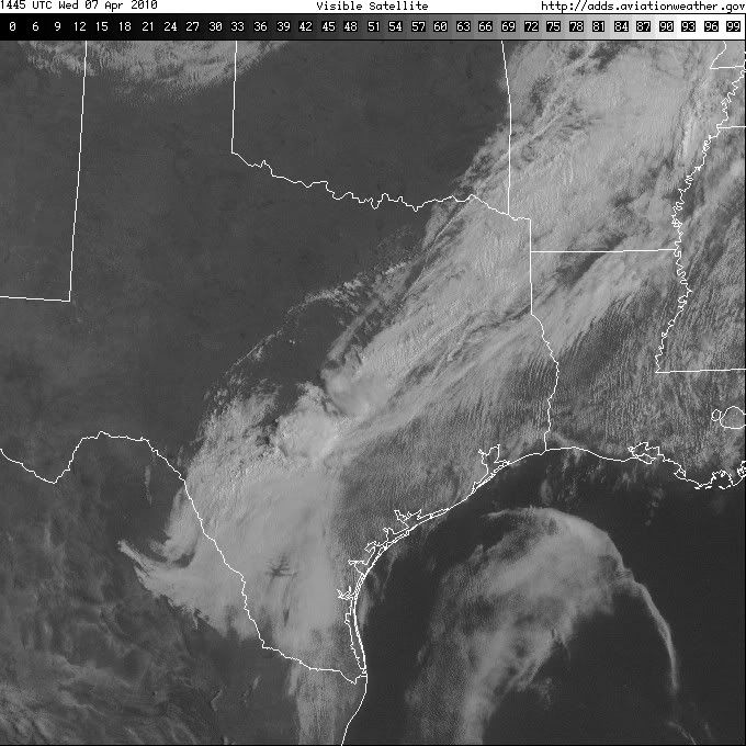
It may be a rouge area of sea fog. The buoy 90 miles south of GLS is reporting fog.Ed Mahmoud wrote:That satellite image- if you loop it, there looks to be some kind of boundary moving North in the Gulf in the general direction of here.
I wonder if that is some kind of outflow boundary, or what. But it might add some low level helicity we seem to be currently lacking.
-
wxdata
- Site Admin
- Posts: 1059
- Joined: Wed Feb 03, 2010 3:04 pm
- Location: Houston, TX
- Contact:
Late morning SPC update- Not much of a change.
Full report:
http://www.spc.noaa.gov/products/outloo ... _1630.html
Full report:
http://www.spc.noaa.gov/products/outloo ... _1630.html
-
wxdata
- Site Admin
- Posts: 1059
- Joined: Wed Feb 03, 2010 3:04 pm
- Location: Houston, TX
- Contact:
Life behind the ol' front - report of pea sized hail in downtown Ft. Worth.
-
srainhoutx
- Site Admin
- Posts: 19700
- Joined: Tue Feb 02, 2010 2:32 pm
- Location: Maggie Valley, NC
- Contact:
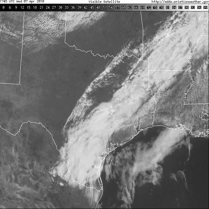
HGX thoughts in Aviation Update. Maybe just a chance after all...
AREA FORECAST DISCUSSION
NATIONAL WEATHER SERVICE HOUSTON/GALVESTON TX
1232 PM CDT WED APR 7 2010
.AVIATION...
COOL FRONT WILL BE ENTERING NRN PARTS OF SE TX IN THE NEXT COUPLE
HOURS AND SHOULD MAKE IT`S WAY TO THE HWY 59 CORRIDOR BY 7 PM AND
OFF THE COAST 9-10PM. CONSIDERABLE CLOUDINESS AND WARM LAYER ALOFT
IS LIMITING INSTABILITY BUT STILL ANTICIPATE SOME SHRA TO DEVELOP
AHEAD OF THE BOUNDARY THIS AFTN AND EVNG. FAIRLY LOW CONFIDENCE
WHETHER ANY TSRA DEVELOP CONSIDERING THE ABOVE FACTORS. THAT BEING
SAID...12Z NAM12/WRF DO SHOW AN INTENSIFYING LINE OF SHRA/TSTMS
LATE IN THE AFTN AS THE BOUNDARY APPROACHES THE HWY 59 CORRIDOR.
SHOULD ANY STORMS MANAGE TO DEVELOP...THEY WILL HAVE THE POTENTIAL
TO BECOME STRONG TO SVR WITH WIND/HAIL BEING PRIMARY THREAT. HAVE
OPTED TO THROW SOME TEMPS TSRA`S IN THE 18Z TAF PACKAGE - BUT DID
NOT INCLUDE STRONG WINDS, LOW VIS, ETC DUE TO THE CONSIDERABLE
UNCERTAINTY. OTHERWISE...SKIES GRADUALLY CLEAR OUT OVERNIGHT AND
SUNNY CONDITIONS EXPECTED AREAWIDE BY SUNRISE THURS. 47
Carla/Alicia/Jerry(In The Eye)/Michelle/Charley/Ivan/Dennis/Katrina/Rita/Wilma/Humberto/Ike/Harvey
Member: National Weather Association
Facebook.com/Weather Infinity
Twitter @WeatherInfinity
Member: National Weather Association
Facebook.com/Weather Infinity
Twitter @WeatherInfinity
-
wxdata
- Site Admin
- Posts: 1059
- Joined: Wed Feb 03, 2010 3:04 pm
- Location: Houston, TX
- Contact:
D/FW NWS description of why the storms behind the front-
"An axis of 400-500 cape from Goldthwaite to the Metroplex. Forcing from the upper trough appears sufficient to realize this instability and convection is forming with bases at 12000 ft."
"An axis of 400-500 cape from Goldthwaite to the Metroplex. Forcing from the upper trough appears sufficient to realize this instability and convection is forming with bases at 12000 ft."
-
srainhoutx
- Site Admin
- Posts: 19700
- Joined: Tue Feb 02, 2010 2:32 pm
- Location: Maggie Valley, NC
- Contact:
Maybe we can squeeze some storms out of this after all...
EDIT: To add just hit 81 in NW Harris County. DP 68
EDIT: To add just hit 81 in NW Harris County. DP 68
Carla/Alicia/Jerry(In The Eye)/Michelle/Charley/Ivan/Dennis/Katrina/Rita/Wilma/Humberto/Ike/Harvey
Member: National Weather Association
Facebook.com/Weather Infinity
Twitter @WeatherInfinity
Member: National Weather Association
Facebook.com/Weather Infinity
Twitter @WeatherInfinity
-
sleetstorm
- Posts: 651
- Joined: Thu Feb 04, 2010 12:33 pm
- Contact:
I do not know about the rest of you, but I am going to focus on a line of rain that only around forty-five miles east-southeast of Austin. It looks like it is trying to get going. By the way, are there any weather instruments that are able to give the altitude of these thunderstorms, as far as how many feet, meters, and miles tall that they are?
-
Paul

- Posts: 535
- Joined: Wed Feb 03, 2010 11:46 pm
- Location: Pearland
- Contact:
NEXRAD radar from Weather underground can give you a good dbz....sleetstorm wrote:I do not know about the rest of you, but I am going to focus on a line of rain that only around forty-five miles east-southeast of Austin. It looks like it is trying to get going. By the way, are there any weather instruments that are able to give the altitude of these thunderstorms, as far as how many feet, meters, and miles tall that they are?
-
sleetstorm
- Posts: 651
- Joined: Thu Feb 04, 2010 12:33 pm
- Contact:
Where do I go to get NEXRAD radar from Weather underground, Paul? Is that a web site or a tool on KHOU's weather center?Paul wrote:NEXRAD radar from Weather underground can give you a good dbz....sleetstorm wrote:I do not know about the rest of you, but I am going to focus on a line of rain that only around forty-five miles east-southeast of Austin. It looks like it is trying to get going. By the way, are there any weather instruments that are able to give the altitude of these thunderstorms, as far as how many feet, meters, and miles tall that they are?
-
wxdata
- Site Admin
- Posts: 1059
- Joined: Wed Feb 03, 2010 3:04 pm
- Location: Houston, TX
- Contact:
They still do in the afternoon update (no mention of central/SE Texas in the update however:)Ed Mahmoud wrote:It'll be inertia or laziness if the 2000 update SWODY1 has HOU in a risk area.
...THERE IS A SLGT RISK OF SVR TSTMS PORTIONS OH/INDIANA/IL SWWD TO
UPPER TX COASTAL PLAIN...
--- UPDATES ---
...LOWER-MID MS VALLEY TO LOWER GREAT LAKES...
BACK EDGE OF GEN TSTM AND SVR OUTLOOK LINES HAVE BEEN ADJUSTED
SLIGHTLY BASED ON LATEST CONVECTIVE TRENDS...WITH ACTIVITY EXPECTED
TO SHIFT GENERALLY EWD ACROSS OUTLOOK AREAS THROUGH REMAINDER PERIOD
AS DESCRIBED BEFORE. BKN LINES OF STG-SVR TSTMS...GROWING IN
COVERAGE AND INTENSITY FROM IL SWWD TO ARKLATEX REGION AS THEY MOVE
INTO DESTABILIZING AIR MASS...ARE COVERED WITHIN SPC WWS 61/62. REF
THOSE PRODUCTS AND RELATED MESOSCALE DISCUSSIONS FOR NEAR-TERM SVR
UPDATES WITH THIS ACTIVITY.
Full report:
http://www.spc.noaa.gov/products/outloo ... _2000.html
-
srainhoutx
- Site Admin
- Posts: 19700
- Joined: Tue Feb 02, 2010 2:32 pm
- Location: Maggie Valley, NC
- Contact:
Appears we have a weak sea breeze boundary moving N. Perhaps that will be the trigger for some storms in another hour or so.
Carla/Alicia/Jerry(In The Eye)/Michelle/Charley/Ivan/Dennis/Katrina/Rita/Wilma/Humberto/Ike/Harvey
Member: National Weather Association
Facebook.com/Weather Infinity
Twitter @WeatherInfinity
Member: National Weather Association
Facebook.com/Weather Infinity
Twitter @WeatherInfinity
-
wxdata
- Site Admin
- Posts: 1059
- Joined: Wed Feb 03, 2010 3:04 pm
- Location: Houston, TX
- Contact:
HAZARDOUS WEATHER OUTLOOK
NATIONAL WEATHER SERVICE HOUSTON/GALVESTON TX
321 PM CDT WED APR 7 2010
321 PM CDT WED APR 7 2010
THIS HAZARDOUS WEATHER OUTLOOK IS FOR PORTIONS OF SOUTHEAST TEXAS.
.DAY ONE...LATE THIS AFTERNOON AND TONIGHT
A COLD FRONT WILL PUSH ACROSS THE REGION THIS EVENING. THE FRONT
SHOULD MOVE ACROSS THE CENTRAL PORTIONS OF SOUTHEAST TEXAS DURING THE
LATE AFTERNOON AND ACROSS THE COAST DURING THE EVENING. SHOWERS
AND THUNDERSTORMS CAN BE EXPECTED NEAR AND ALONG THIS FRONT. SOME
OF THE STORMS MAY BECOME SEVERE THIS AFTERNOON ESPECIALLY OVER THE
NORTHEAST PORTIONS OF SOUTHEAST TEXAS...MAINLY ALONG AND NORTHEAST
OF A MADISONVILLE TO HUNTSVILLE TO LIVINGSTON LINE. THE MAIN
THREAT WILL BE LARGE HAIL AND DAMAGING WINDS.
-
wxdata
- Site Admin
- Posts: 1059
- Joined: Wed Feb 03, 2010 3:04 pm
- Location: Houston, TX
- Contact:
Winter returns to North Texas:
SPECIAL WEATHER STATEMENT
NATIONAL WEATHER SERVICE FORT WORTH TX
335 PM CDT WED APR 7 2010
335 PM CDT WED APR 7 2010
...PATCHY FROST POSSIBLE TONIGHT...
A COLD FRONT WILL BRING COOLER TEMPERATURES TO THE AREA TONIGHT.
SKIES ARE EXPECTED TO BE CLEAR...AND WINDS WILL BECOME NEARLY CALM
BY SUNRISE. THIS WILL ALLOW TEMPERATURES TO FALL INTO THE MID TO
UPPER 30S WEST OF I-35. IN SOME SHELTERED AREAS...SUCH AS VALLEYS
OR LOW LYING REGIONS...TEMPERATURES WILL BE COLD ENOUGH FOR PATCHY
FROST TO FORM. FROST CAN BE AS DAMAGING AS A LIGHT FREEZE TO SOME
COLD-SENSITIVE PLANTS. RESIDENTS MAY WISH TO PROTECT THESE PLANTS.
-
srainhoutx
- Site Admin
- Posts: 19700
- Joined: Tue Feb 02, 2010 2:32 pm
- Location: Maggie Valley, NC
- Contact:
Sea breeze boundary just past us in NW Harris County. Perhaps you were Ed.Ed Mahmoud wrote:Could be lightning in the activity North of UTS...
Maybe I was premature ruling out the extreme Northernmost counties...
Carla/Alicia/Jerry(In The Eye)/Michelle/Charley/Ivan/Dennis/Katrina/Rita/Wilma/Humberto/Ike/Harvey
Member: National Weather Association
Facebook.com/Weather Infinity
Twitter @WeatherInfinity
Member: National Weather Association
Facebook.com/Weather Infinity
Twitter @WeatherInfinity
-
wxdata
- Site Admin
- Posts: 1059
- Joined: Wed Feb 03, 2010 3:04 pm
- Location: Houston, TX
- Contact:
Yes there is!Could be lightning in the activity North of UTS...