
March 2023
-
Stratton20
- Posts: 5818
- Joined: Tue Feb 09, 2021 11:35 pm
- Location: College Station, Texas
- Contact:
It makes no sense that the CPC has a high risk of moderate temp’s in our neck of the woods, i do see winter like temp’s dominating the weather for the next couple of weeks, but I am perplexed as too why they have a high risk in place, i dont see anything that suggests that in the models
-
Thundersleet
- Posts: 67
- Joined: Thu Dec 22, 2016 12:26 am
- Contact:
Seaside, FL is south of Melbourne. Like Melbourne, AUS, The Land Down Under, mate!
-
Thundersleet
- Posts: 67
- Joined: Thu Dec 22, 2016 12:26 am
- Contact:
I have heard the Florida Keys including Key West & seven miles bridge or hwy are picturesquely serene form talking with some people in the past as well as in various form of media.
-
Ptarmigan

- Statistical Specialist

- Posts: 4521
- Joined: Wed Feb 03, 2010 7:20 pm
- Contact:
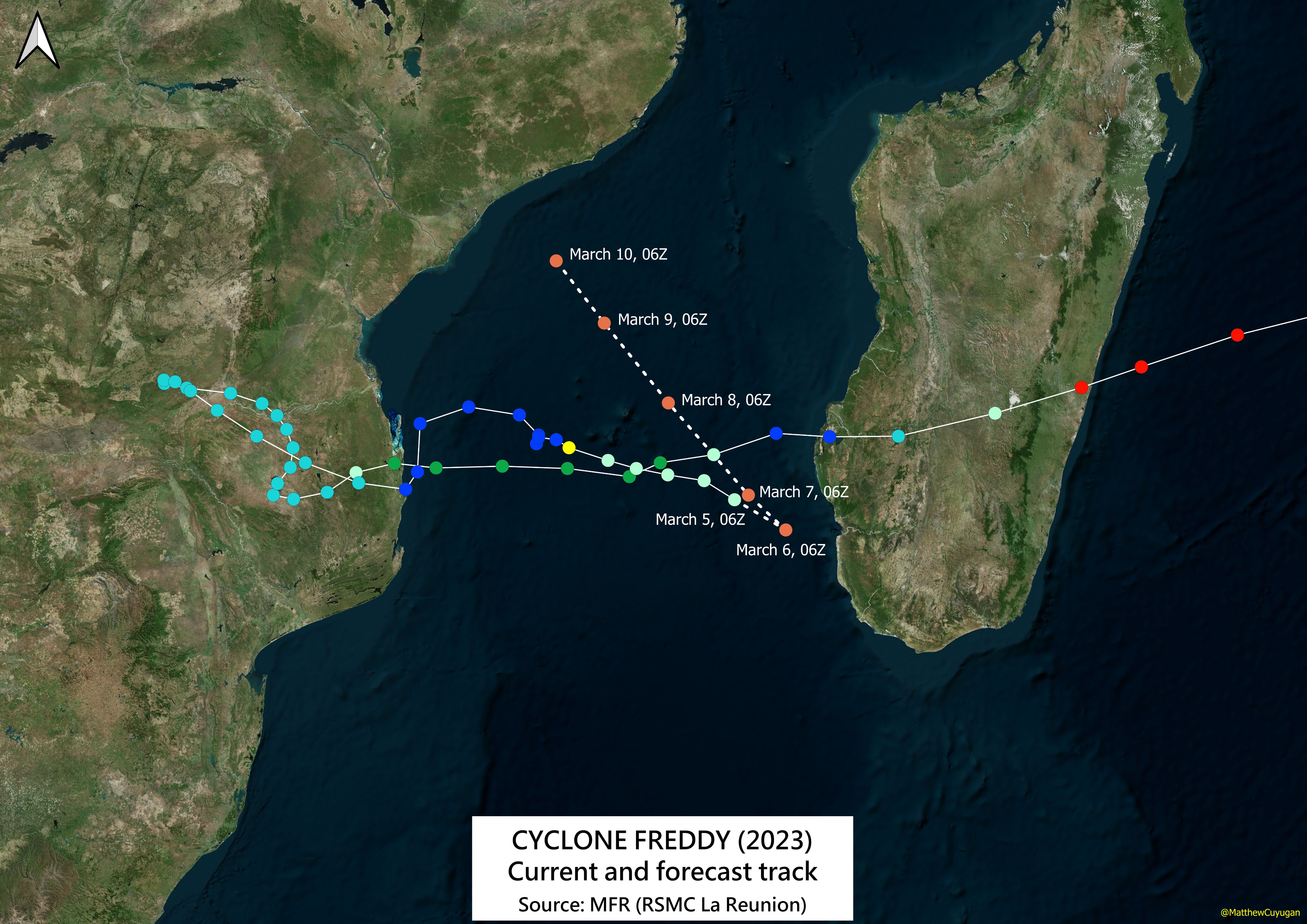
A bit off topic. Tropical Cyclone Freddy in the South Indian Ocean has last for about a month. It could be the longest lived tropical cyclone. The longest lived tropical cyclones are Hurricane/Typhoon John (1994) in the pacific and Tropical Cyclone Leon–Eline (2000) in the South Indian Ocean.
https://twitter.com/MatthewCuyugan/stat ... 4944900096
https://twitter.com/MatthewCuyugan/stat ... 4944900096
Matthew Cuyugan
@MatthewCuyugan
Here's the latest track of Cyclone #Freddy from MFR (RSMC La Réunion) as of 06Z today, March 5, 2023, in its unusual 28.75-day journey.
The storm is expected to slow down, then will recurve to the northwest to Mozambique, due to the strengthening of the HPA in the south.
-
jasons2k

- Posts: 6193
- Joined: Thu Feb 04, 2010 12:54 pm
- Location: Imperial Oaks
- Contact:
My Dad lived in Key West and on Big Pine Key for about 15 years of his retirement. It was beautiful. We used to go to the beach (Bahia Honda) next to the bridge.Thundersleet wrote: ↑Sun Mar 05, 2023 12:57 am I have heard the Florida Keys including Key West & seven miles bridge or hwy are picturesquely serene form talking with some people in the past as well as in various form of media.
-
DoctorMu

- Posts: 8030
- Joined: Sun Jun 28, 2015 11:58 am
- Location: College Station
- Contact:
Late freezes around Spring Break in CLL and Aggieland are almost a tradition.
It will be cool for a few days during Spring Break, but the models and Ensembles don't see a hard freeze right now. We'll see.
-
DoctorMu
- Posts: 8030
- Joined: Sun Jun 28, 2015 11:58 am
- Location: College Station
- Contact:
haha I don't look at AccuWeather very much but they have great weather beginning next Saturday for the remained of the month in the 60s and 70s for highs until April. If it could only happen!
-
Stratton20
- Posts: 5818
- Joined: Tue Feb 09, 2021 11:35 pm
- Location: College Station, Texas
- Contact:
More like wrongyuweather , i laugh when looking at their month by month forecasts,
-
tireman4

- Global Moderator

- Posts: 7127
- Joined: Wed Feb 03, 2010 9:24 pm
- Location: Humble, Texas
- Contact:
000
FXUS64 KHGX 061146
AFDHGX
Area Forecast Discussion
National Weather Service Houston/Galveston TX
546 AM CST Mon Mar 6 2023
...New AVIATION...
.SHORT TERM...
(Today through Tuesday Night)
Issued at 152 AM CST Mon Mar 6 2023
An increasing trend in both temperature and humidity can be expected
throughout the first half of the week as the synoptic pattern
remains generally characterized by a broad area of surface high
pressure over the Eastern Gulf and a relatively weak surface low
over the TX Panhandle. The resultant onshore gradient winds will
promote increased temperatures over the next several days, along
with gradually building surface dew points/total PW values. Have
decided to trend high temperatures both today and on Tuesday away
from deterministic NBM and towards the NBM 50th percentile given the
presence of SW midlevel flow. This has generally resulted in a 1-2
deg increase in forecast maximum temperatures, a change also
supported by scattering cloud cover during the daytime hours.
Overnight lows are expected to settle into the upper 60s in most
location, with some areas on Tuesday unlikely to drop below 70 given
the persistence and gradually increasing strength of SE low-level
winds.
One consequence of this synoptic pattern to note is the expected
favorable conditions for fog development that should persist over
the next several days. With bay temperatures sitting in the
mid/upper 60s and offshore dew points of around 70, the development
of marine advection fog is expected both tonight and tomorrow night.
Additionally, with increasing low-level moisture and relatively
light winds, radiation fog could also develop inland. This could
result in some hazardous travel conditions through mid-week,
particularly during the overnight and morning hours. Continue to
monitor local road conditions and allow yourself some extra commute
time as a result of this potential hazard.
Cady
&&
.LONG TERM...
(Wednesday through Sunday)
Issued at 152 AM CST Mon Mar 6 2023
Warm and humid conditions will persist through the rest of the
workweek as southerly flow continues and a strong mid-level ridge
builds over the Midwest. High temperatures Wednesday and Thursday
will climb into the mid to even upper 80s across the area with
overnight lows in the mid to upper 60s. There will be a slight
chance to a chance of showers north of Conroe Thursday afternoon
as a slow moving boundary begins to approach the area. The forecast
becomes a bit tricker come Friday as this front moves further into
the area - but how far it makes it into the area before stalling
is uncertain. Currently expecting this front to make it to around
I-10, but confidence is not high. As the boundary moves into the
area, expect scattered showers and isolated thunderstorms Friday
morning into the afternoon. A very shallow cold airmass behind
this front will quickly get mixed out, but temperatures will cool
down into the low to mid 70s across the northern portion of the
region on Friday with areas south of I-10 getting into the upper
70s to mid 80s. The boundary will move back to the north towards
the Red River Valley by Saturday morning, but the cooler
temperatures will stick around with highs in the mid to upper 70s
through the weekend. The boundary will make a return Sunday night
as a more pronounced cold front bringing back the chance of
precipitation.
Fowler
&&
.AVIATION...
(12Z TAF Issuance)
Issued at 541 AM CST Mon Mar 6 2023
MVFR to IFR conditions continue to prevail across the area this
morning with both fog and widespread low stratus currently in
place. These conditions should gradually improve over the next 2-3
hours, after which a return to VFR conditions is expected by late
morning. Light south to southeast winds will persist through the
day, remaining at around 5 to 10 knots. Tomorrow evening,
persistent onshore winds will continue to supply the necessary
moisture for the development of another round of fog/low cigs,
which will be aided by light winds. Marine fog may also develop
along the immediate coast.
Cady
&&
.MARINE...
Issued at 152 AM CST Mon Mar 6 2023
Main forecast concern this week will be the potential for nightly
patchy sea fog as moist onshore flow persists through next
weekend. Fog potential is generally decreasing as sea surface
temperatures rise to near 70 degrees, but cannot out rule patchy
sea fog in the near shore waters. A weak front will approach and
then stall inland on Friday bringing a slight chance of showers.
Fowler
&&
.PRELIMINARY POINT TEMPS/POPS...
College Station (CLL) 81 64 84 66 / 0 10 0 0
Houston (IAH) 83 68 85 70 / 10 10 0 0
Galveston (GLS) 76 69 76 71 / 0 10 0 0
&&
.HGX WATCHES/WARNINGS/ADVISORIES...
TX...None.
GM...None.
&&
$$
SHORT TERM...Cady
LONG TERM....Fowler
AVIATION...Cady
MARINE...Fowler
-
tireman4
- Global Moderator
- Posts: 7127
- Joined: Wed Feb 03, 2010 9:24 pm
- Location: Humble, Texas
- Contact:
.AVIATION...
(18Z TAF Issuance)
Issued at 1146 AM CST Mon Mar 6 2023
Lingering IFR/MVFR ceilings from the overnight fog development
will continue to improve going into the afternoon hours with light
southwesterly to southerly winds helping to mix things out.
Expect a repeat going into the evening/overnight hours as ceilings
and visibilities will decrease from south to north beginning
around 03Z along the coast, 05Z around HOU/IAH, and 09Z at the far
northern sites. Model guidance continues to suggest LIFR ceilings
and visibility due to fog, especially between 09Z-15Z Tuesday.
Visibilities will begin to improve after 15Z/16Z, but ceilings
will take till the afternoon to gradually improve from LIFR back
to MVFR. VFR ceilings may hold off till the mid afternoon hours
around 21Z, and a bit later along the coast. Expect southerly to
southeasterly winds to prevail on Tuesday.
Batiste
-
snowman65

- Posts: 1415
- Joined: Thu Feb 04, 2010 6:39 am
- Location: Orange, Tx
- Contact:
summer is here way too early. Come on, November!!!
-
jasons2k
- Posts: 6193
- Joined: Thu Feb 04, 2010 12:54 pm
- Location: Imperial Oaks
- Contact:
From CNN:
Here are a few cities that experienced their top five warmest meteorological winters (December 1, 2022, through February 28, 2023):
Tupelo, Mississippi – 1st warmest
New York City (Central Park) - 2nd warmest
Miami – 2nd warmest
Atlanta (Hartsfield International Airport) - 2nd warmest
Houston – 2nd warmest
Washington, DC - 3rd warmest
New Orleans – 3rd warmest
Nashville – 4th warmest
Boston – 5th warmest
Dallas Fort Worth – 5th warmest
https://www.cnn.com/2023/03/06/weather/ ... index.html
-
Stratton20
- Posts: 5818
- Joined: Tue Feb 09, 2021 11:35 pm
- Location: College Station, Texas
- Contact:
A miserable 84 degrees here with feels like temp near 90, the beach cant get here soon enough!

-
Ptarmigan
- Statistical Specialist
- Posts: 4521
- Joined: Wed Feb 03, 2010 7:20 pm
- Contact:
Tropical Cyclone Freddy continues on near Madagascar. Could be the longest lived tropical cyclone known.
https://twitter.com/DRmetwatch/status/1 ... 1819441152
https://twitter.com/DRmetwatch/status/1 ... 1819441152
David Roth
@DRmetwatch
Even though Freddy’s circulation has been around roughly a month, JTWC has issued 49 advisories at a twice a day interval. Dates they’ve considered it a tropical cyclone stretch 26 of the 29 days (over a month because February). Still 4 more days to beat John 1994.

-
Thundersleet
- Posts: 67
- Joined: Thu Dec 22, 2016 12:26 am
- Contact:
I concur with you snowman65. I am not in slightest happy with this unseasonably warm Winter Texas & southeast Tx has been getting. I accept it, just am not that happy with it.
-
Cromagnum
- Posts: 3065
- Joined: Thu Feb 03, 2011 10:42 pm
- Location: Georgetown
- Contact:
Hot, humid, and no rain. Yeah, feels like we are in the summer slog already.
-
Cpv17
- Posts: 7091
- Joined: Fri Aug 31, 2018 1:58 pm
- Location: El Campo/Wharton
- Contact:
This pattern is sh*t! Way above average temps and no good rain chances in sight. I sure hope that changes soon. Hoping for an SOI crash and for a fast transition to El Niño. There’s plenty of storm systems out there coming across but they keep passing too far to our north. None of them are digging. No buckle in the jet stream. Very frustrating.
-
Stratton20
- Posts: 5818
- Joined: Tue Feb 09, 2021 11:35 pm
- Location: College Station, Texas
- Contact:
No kidding about that, this pattern is absolutely atrocious
-
DoctorMu
- Posts: 8030
- Joined: Sun Jun 28, 2015 11:58 am
- Location: College Station
- Contact:
The forecast has taken a turn for the worse re: cool air.
-
davidiowx
- Posts: 1197
- Joined: Thu Jan 23, 2014 2:39 pm
- Location: Richmond, TX
- Contact:
Is it ever going to rain? My goodness, this is getting ridiculous