Re: April Weather Discussion. Severe Weather Chances To Incr
Posted: Tue Apr 06, 2010 10:06 am
Morning e-mail from Jeff...could get interesting after all...and looking at guidance from overnight, next week may offer better chances of severe weather. We shall see.
Strong onshore flow continues to pump low level moisture into the area this morning. Low level stratus deck in not as thick and higher based than recent mornings, and would expect this deck to break and scatter by late morning as opposed to early afternoon.
Main forecast concern focuses around convective chances on Wednesday and winds this afternoon. Already getting 30-35mph gust over the coastal bend locations this morning and with the onset of heating and deeper mixing of the low level jet above the surface expecting some healthy winds today. Strongest winds will be found over the Matagorda Bay area southward toward CRP.
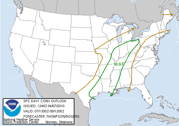
Next storm system will arrive into the plains Wednesday with strong surface low pressure lifting toward the Great Lakes. Main dynamics will pass well north of SE TX, but southern edge of colder mid level temperatures and lift will sweep across at least the northern half of SE TX late Wednesday. Impressive capping noted on CRP and LCH soundings this morning will have to be weakened and breached to allow thunderstorms to develop. Latest NAM guidance completely erodes this feature by Wednesday afternoon while the GFS maintains at least some degree of inhibition. Cold front (and a fairly strong one for early April) will arrive into SE TX early Wed afternoon and reach the coast toward early to mid evening. This timing supports the best lift will coincide with the strongest heating and best opportunity to break the capping inversion. Models are not overly aggressive with rain chances or convection, but instead show a broken line of showers/thunderstorms. Recent events have failed to break the capping inversion as the models have been under-forecasting its intensity of late. I am tempted to side with the low rain chances and stronger inversion, however SPC has outlooked a good part of the area for a slight risk of severe thunderstorms and long period of moist southerly flow off the Gulf has finally returned some decent quality moisture to the area. Feel a few parcels will breach the inversion and develop into strong/severe thunderstorms Wednesday afternoon/evening. Best chances will be over our NE counties with the lowest chances around Matagorda Bay where the cap will be strongest. Will need to closely watch trend early Wednesday for additional defining of the severe weather threat…it is one of those situations where you could get a good round of storms or nothing at all.
Post frontal air mass is chilly for early April and will see lows back into the 40’s for many locations Thursday and Friday mornings with highs in the upper 60’s to lower 70’s. Return flow off the Gulf begins by Saturday ahead of a fairly strong looking system over the SW US early next week. W TX dry line looks to form up with active thunderstorm chances Mon-Tues of next week.