

My digital gauge is reading 6.61" for May but I've dumped more than that from the cylinder. Yes, I am very glad we are getting this much-needed rainfall going into the summer season. At the same time I've had my fill now. I want my pool to be built and it can't happen when it's raining.
May 2021:

-
tireman4

- Global Moderator

- Posts: 4515
- Joined: Wed Feb 03, 2010 9:24 pm
- Location: Humble, Texas
- Contact:
000
FXUS64 KHGX 231146
AFDHGX
Area Forecast Discussion
National Weather Service Houston/Galveston TX
646 AM CDT Sun May 23 2021
.AVIATION [12Z TAF Issuance]...
Scattered light to moderate rain showers have spread across the
area. MVFR conditions will develop across the area through the
morning with CIGs between 1500 to 2500 ft. LBX will have the best
chance to see some moderate to heavy rain reducing visibilities
to below 2 miles at times through the day, along with a chance of
isolated thunderstorms. The rest of the terminals should just
experience scattered showers. CIGs lower to 1000ft or lower region
wide tonight through early tomorrow morning. Southeasterly flow
persists.
Fowler
&&
.PREV DISCUSSION /Issued 334 AM CDT Sun May 23 2021/...
.SHORT TERM [Through Monday Night]...
High pressure continues to sit over the southeastern US ushering in
moist southeasterly flow into our region with an upper level low
located near south Texas. Weak shortwaves embedded in the flow aloft
combined with PWATs between 2 and 2.2 inches will lead to another
day of light to moderate scattered showers. Areas west of I-45 will
have higher chances of precipitation as the high pressure to the
east slowly begins to expand westward. Have continued the Flash
Flood Watch for the southwestern counties because despite the light
to moderate rain rates, the ground is very saturated so FFG is
fairly low. Precipitation continues through tonight as the
aforementioned upper level low that has been down near south Texas
gets picked up by and absorbed into the southeasterly flow and
brought into our area. This will increase coverage of showers and
thunderstorms through Monday evening across the area. Rainfall
totals will generally be up to an additional 1 to 2 inches today
across the southwestern counties, and then up to an additional 1
inch across the entire area on Monday. The showers will be fairly
scattered in nature, so some areas may only get a trace to half an
inch. Lack of upper level support will lead to a decrease in shower
activity Monday night, though cannot out rule some isolated light
showers due to continued high PWATs.
Temperatures through the short term will continue to be fairly
persistent. High temperatures will be in the low 80s this afternoon,
and then slightly cooler on Monday thanks to the increased
precipitation coverage. Low temperatures tonight and Monday night be
around 70.
Fowler
.LONG TERM [Tuesday through Sunday]...
Shower and thunderstorm chances will remain in the forecast on Tuesday
and Wednesday as weak disturbances continue to move across the area.
By Wednesday, mid/upper level ridging does begin to build into the
state, and this should end up helping Wednesday`s rain coverage to be
a little more scattered or maybe even isolated and mainly in the
afternoon. The ridge then strengthens into the state for the remainder
of the week resulting in a dry forecast with warming temperatures.
At this time, next weekend looks to feature a weakening of the ridge
probably allowing for some mainly isolated afternoon shower and
thunderstorm development across parts of our central and northern
counties. 42
.MARINE...
Elevated winds and seas will persist for the next several days with
slightly lower levels anticipated heading into Monday night and
Tuesday. Will carry a combination of Caution and Advisory flags
today, and some of them (especially the 20-60 nm waters) will
probably need to be extended into tonight and Monday. Periods of
showers and thunderstorms can be expected through Tuesday.
Tide levels will remain elevated. 42
.CLIMATE...
With yesterday`s rainfall, PSX`s monthly total now stands at
15.39 inches which is 12.83 inches above normal. Dating back to
1943 and with nine days still left in the month, this total ranks
as their wettest May on record (second place is 13.23 inches set
in 1972). This total also currently ranks as their 9th wettest
month on record (dating back to February 1943). Their wettest
month on record is 24.28 inches set in October 1949.
Some other month to date rainfall totals are...
-CLL at 4.86 inches (1.58 inches above normal). Wettest May is
14.70 inches set in 1929.
-IAH at 8.36 inches (4.97 inches above normal). Wettest May is
15.87 inches set in 1907.
-HOU at 6.91 inches (3.23 inches above normal). Wettest May is
14.84 inches set in 1970.
-GLS at 6.05 inches (4.07 inches above normal). Wettest May is
11.03 inches set in 1991.
42
&&
.PRELIMINARY POINT TEMPS/POPS...
College Station (CLL) 80 68 79 69 83 / 70 50 70 20 60
Houston (IAH) 80 70 80 70 84 / 50 50 70 20 50
Galveston (GLS) 82 74 80 74 82 / 50 50 70 20 30
&&
.HGX WATCHES/WARNINGS/ADVISORIES...
TX...Flash Flood Watch through Monday morning for the following
zones: Coastal Jackson...Coastal
Matagorda...Colorado...Inland Jackson...Inland
Matagorda...Wharton.
High Rip Current Risk through this evening for the following
zones: Bolivar Peninsula...Brazoria Islands...Galveston
Island...Matagorda Islands.
Coastal Flood Advisory until 7 AM CDT this morning for the
following zones: Bolivar Peninsula...Brazoria
Islands...Chambers...Coastal Brazoria...Coastal
Galveston...Coastal Harris...Galveston Island...Matagorda
Islands.
GM...SMALL CRAFT SHOULD EXERCISE CAUTION through this evening for the
following zones: Galveston Bay...Matagorda Bay.
Small Craft Advisory until 7 AM CDT this morning for the
following zones: Coastal waters from Freeport to Matagorda
Ship Channel TX out 20 NM...Coastal waters from High Island
to Freeport TX out 20 NM.
SMALL CRAFT SHOULD EXERCISE CAUTION through this evening for the
following zones: Coastal waters from Freeport to Matagorda
Ship Channel TX out 20 NM...Coastal waters from High Island
to Freeport TX out 20 NM.
Small Craft Advisory until 7 PM CDT this evening for the
following zones: Waters from Freeport to Matagorda Ship
Channel TX from 20 to 60 NM...Waters from High Island to
Freeport TX from 20 to 60 NM.
&&
$$
The latest 12z Euro keeps the rainy pattern around for a while bringing in anywhere from 2” to 7” across southeast TX.
-
Stratton20
- Posts: 4267
- Joined: Tue Feb 09, 2021 11:35 pm
- Location: College Station, Texas
- Contact:
Cpv17 how long does the Euro keep the rainy pattern for?
Well it only goes out to 240 hours which is 10 days but it has a couple inches around for the next few days and then a couple more inches next Sunday.Stratton20 wrote: ↑Sun May 23, 2021 2:34 pm Cpv17 how long does the Euro keep the rainy pattern for?

Good rains in Friendswood today.
Some of the mesoscale models are pumping out some big totals for the next couple days.
We haven’t had much here today which is kinda surprising because we were basically right in the middle of the firehose. Only .20” today here so far but it’s looking like more is on the way the next few days. The ground is completely waterlogged.
I've had a few sprinkles today but nothing measurable. The digital gauge shows still 0.00" Kinda strange with the radar being so busy all day.
Picked up .48” today. It came in random spurts, nothing crazy by any means. Honestly wouldn’t mind some drying out at this point.. As crazy as that sounds lol
-
Stratton20
- Posts: 4267
- Joined: Tue Feb 09, 2021 11:35 pm
- Location: College Station, Texas
- Contact:
Wish the weather would be like this every day, I cant stand those hot and dry 90+ degrees and high humidty weather


Stratton20 wrote: ↑Sun May 23, 2021 7:35 pm Wish the weather would be like this every day, I cant stand those hot and dry 90+ degrees and high humidty weather
Yep. I'd take this lemonade squirt gun (not powerful enough for a firehose designation) all summer long. Bushes, trees, grass loving it. No sprinklers and the A/C is barely running.
This spring has been a lot more like a North Carolina spring than typical Texas. Let's keep it going!
-
Stratton20
- Posts: 4267
- Joined: Tue Feb 09, 2021 11:35 pm
- Location: College Station, Texas
- Contact:
DoctorMu I agree the spring has been pretty nice, dont think we have hit 90 degrees yet, although we can pretty much kiss these cooler temps goodbye especially towards july and august, then its back to the typical furnace heat in the summer
Another round in Friendswood.
We’ve been getting popped all day.
We’ve been getting popped all day.
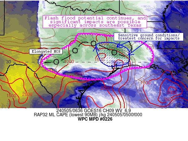
Mesoscale Precipitation Discussion 0226
NWS Weather Prediction Center College Park MD
512 AM EDT Mon May 24 2021
Areas affected...Middle and Upper Texas Coast into the Hill
Country
Concerning...Heavy rainfall...Flash flooding possible
Valid 240910Z - 241400Z
Summary...Showers and thunderstorms developing within a pronounced
moisture plume advecting from the Gulf of Mexico will increase in
coverage through morning. Rainfall rates of 2"/hr are likely, and
as these storms move slowly and train to the northwest, 1-3" of
rainfall is likely with locally higher amounts. Flash flooding is
possible.
Discussion...Mid-level trough axis which has plagued Texas for
several days now is slowly beginning to weaken, but will maintain
its position across western portions of the state through this
morning. East of this trough, a shortwave evident on GOES-E WV
imagery is lifting slowly northward along the I-35 corridor near
Austin. Beneath this shortwave, mid-level lapse rates are becoming
subtly steeper, which is combining with increasing onshore flow
from the Gulf of Mexico to enhance instability across eastern and
southeastern Texas. A tropical moisture plume of PWs above 1.8"
according to GPS observations is also lifting onshore, and the
combination of these features has led to slowly expanding coverage
of showers and thunderstorms early this morning on KHGX and KCRP
WSR-88D reflectivity.
As the shortwave continues to lift northward through the morning,
model fields indicate that both instability and moisture will be
drawn more efficiently northward. MUCape is forecast to rise
towards 2000 J/kg, while PWs may approach 2", well above the 90th
percentile for the date. This should produce increasingly
efficient rain rates, and the HREF probabilities indicate the
potential for 2"/hr rates across the region. In the vicinity of
the shortwave aloft, mean winds weaken to 5-10 kts, suggesting
storm motions inland will be quite slow. Nearer to the coast
850-300mb mean winds may be as high as 20 kts, but Corfidi vectors
angled against this mean wind suggests backbuilding into the
greater instability over the Gulf is likely, with regeneration and
training leading to heavy rainfall accumulations.
The high res guidance this morning agrees that an axis of rainfall
exceeding 2" is likely, but the longitudinal placement varies
considerably. However, recent rainfall has been excessive,
reaching 600% of normal the past 7 days, and this is reflected by
soil moisture that is above the 98th percentile to a depth of
100cm according to NASA sport, leading to 3-hr FFG as low as 2".
These efficient rain rates could quickly turn to runoff as these
soils cannot handle additional rainfall, so any training or
backbuilding could lead to pockets of flash flooding anywhere
within the discussion area.
Weiss
ATTN...WFO...CRP...EWX...FWD...HGX..

WPC has added the area to a slight risk for flooding.
- Attachments
-
I can't help but hear Les Miz' "One Day More" as background music when I read this
https://spacecityweather.com/recapping- ... -sunshine/
https://spacecityweather.com/recapping- ... -sunshine/
-
- Information
-
Who is online
Users browsing this forum: Ahrefs [Bot], Amazon [Bot], Bing [Bot], Cromagnum, Semrush [Bot] and 58 guests