
Hurricane Alex. 40 Miles NNE of La Pesca. 100 MPH/948MB
-
Hardcoreweather
BRO: Brownsville [Cameron Co, TX] nws employee reports HURRICANE at 07:28 PM CDT -- nws employee reports widespread power outages in city of brownsville.
-
Bluefalcon
- Posts: 129
- Joined: Fri Jun 25, 2010 6:14 pm
- Location: Round Rock, TX
- Contact:
They have been hammered all day by feeder bands. Hang on down there!Hardcoreweather wrote:BRO: Brownsville [Cameron Co, TX] nws employee reports HURRICANE at 07:28 PM CDT -- nws employee reports widespread power outages in city of brownsville.
Put the wet stuff on the red stuff!

Power on and off in Padre, squalls pretty bad.
(from my cousin)
(from my cousin)
-
Bluefalcon
- Posts: 129
- Joined: Fri Jun 25, 2010 6:14 pm
- Location: Round Rock, TX
- Contact:
Recon going in for one more pass before landfall. The mission started at 14:30Z. The latest position time was 00:38. They have been out there for 10 hours with more to go. I wonder if they are going back to Keesler or will land to refuel and rest somewhere in Texas, like Ellington or SA?
Put the wet stuff on the red stuff!
-
Bluefalcon
- Posts: 129
- Joined: Fri Jun 25, 2010 6:14 pm
- Location: Round Rock, TX
- Contact:
I know your cousin is going through a lot. When this is all said and done with power back on and clean-up done, It would be cool to see some photos (like earlier) and some video if he's able.Rip76 wrote:Power on and off in Padre, squalls pretty bad.
(from my cousin)
Put the wet stuff on the red stuff!
Here comes the rain in Houston

Eyewall touching the coast...
-
Bluefalcon
- Posts: 129
- Joined: Fri Jun 25, 2010 6:14 pm
- Location: Round Rock, TX
- Contact:
Almost at landfall: http://www.tceq.state.tx.us/assets/publ ... f0015.jpeg
Put the wet stuff on the red stuff!
Two day air pressure trend at South Padre Island. Notice how it has spiked upward last few hours.
-
polisciaggie

- Posts: 19
- Joined: Wed Feb 03, 2010 10:06 pm
- Location: Houston, TX
- Contact:
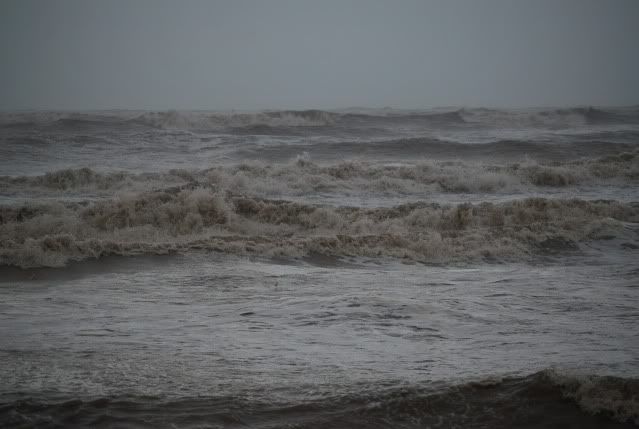
Wanted to share a picture that I took at Sargent Beach about an hour ago. The tide was almost going over the road there by the beach, and the intercoastal had already flooded over the bank.


Alex has 948 mb and 100 mph, that's almost in Ike's territory when it was over GOM.
NOUS44 KBRO 010148
PNSBRO
TXZ248>257-010500-
PUBLIC INFORMATION STATEMENT
NATIONAL WEATHER SERVICE BROWNSVILLE TX
848 PM CDT WED JUN 30 2010
...UPDATED PRELIMINARY RAINFALL TOTALS AND WIND GUSTS...
THE FOLLOWING ARE THE MOST CURRENT STORM TOTALS AND WIND GUSTS
FROM A COMBINATION OF AUTOMATED OBSERVING SITES...MESO
NETWORKS...AND COOPERATIVE AND PUBLIC OBSERVERS. WE THANK ALL
THOSE PROVIDING RAPID UPDATES THROUGH THE STORM.
RAINFALL
LOCATION COUNTY RAINFALL (IN)
BROWNSVILLE EOC CAMERON 6.76
BROWNSVILLE/AIRPORT CAMERON 6.02
BROWNSVILLE/4.2 NE CAMERON 5.97
HARLINGEN/VALLEY CAMERON 2.13
HARLINGEN/STUART PLC-BUS 83 CAMERON 5.50
MCALLEN/MILLER HIDALGO 5.29
BAYVIEW/CAMERON CO CAMERON 4.58
SOUTH PADRE ISLAND CAMERON 4.69
WESLACO/MID VALLEY HIDALGO 5.49
EDINBURG HIDALGO 5.01
FALFURRIAS/BROOKS CO BROOKS 3.16
HEBBRONVILLE/JIM HOGG CO JIM HOGG 1.21
ZAPATA ZAPATA 0.79
SANTA ANA/LOWER RGV NWR HIDALGO 5.30
ATASCOSA/LOWER RGV NWR CAMERON 3.59
SAN MANUEL/LOWER RGV NWR HIDALGO 3.85
FALCON LAKE/UPPER RGV NWR ZAPATA 1.68
SHARYLAND HIDALGO 6.00
TXDOT CAUSEWAY SITE CAMERON 5.39
SEBASTIAN WILLACY 5.00
LOS FRESNOS CAMERON 4.46
ALAMO HIDALGO 5.00
PEAK WINDS
LOCATION
TXDOT CAUSEWAY SITE CAMERON 66 MPH AT 800 PM
SOUTH PADRE ISLAND CAMERON 56 MPH AT 435 PM
BAYVIEW/CAMERON COUNTY CAMERON 52 MPH AT 755 PM
BROWNSVILLE/AIRPORT CAMERON 48 MPH AT 352 PM
HARLINGEN/VALLEY CAMERON 49 MPH AT 513 PM
MCALLEN/MILLER HIDALGO 48 MPH AT 142 PM
WESLACO HIDALGO 41 MPH AT 345 PM
EDINBURG HIDALGO 41 MPH AT 345 PM
ZAPATA ZAPATA 32 MPH AT 345 PM
FALFURRIAS/BROOKS CO BROOKS 32 MPH AT 610 PM
HEBBRONVILLE/JIM HOGG CO JIM HOGG 36 MPH AT 501 PM
NOTES: PEAK WINDS WERE LIKELY MUCH HIGHER IN EMBEDDED TORNADOES
REPORTED EARLIER TODAY. SOUTH PADRE ISLAND RAINFALL INCLUDES ONLY
TODAYS REPORTED AMOUNT. TXDOT CAUSEWAY SITE...LOCATED ON THE QUEEN
ISABELLA MEMORIAL BRIDGE BETWEEN SOUTH PADRE ISLAND AND PORT
ISABEL...IS AN ESTIMATED WIND GUST TIME. MCALLEN/MILLER PEAK WIND
REPORT OCCURRED ON THE 29TH.
ADDITIONAL PEAK WINDS AND RAINFALL REPORTS WILL BE AVAILABLE EVERY
COUPLE OF HOURS OR SO.
-
Hardcoreweather
BRO issues Tornado Warning for Hidalgo [TX] till 9:15 PM CDT ...* AT 858 PM CDT...NATIONAL WEATHER SERVICE DOPPLER RADAR INDICATED A TORNADO OVER NORTHEASTERN HIDALGO COUNTY...MOVING WEST AT 45 MPH
-
Hardcoreweather
Landfall
hurricane alex tropical cyclone update
nws tpc/national hurricane center miami fl al012010
900 pm cdt wed jun 30 2010
...alex makes landfall in northeastern mexico...
national weather service doppler radar from brownsville texas and air force reserve unit hurricane hunter observations indicate that the eye of hurricane alex made landfall around 9 pm cdt...0200 utc along the coast of mexico in the municipality of soto la marina...
about 110 mi...180 km south of brownsville. maximum sustained winds at landfall were estimated to be 105 mph...165 km/hr...a category two hurricane on the saffir-simpson hurricane wind scale.
summary of 900 pm cdt...0200 utc...information
--------------------------------------------------
location...24.3n 97.7w
about 35 mi...55 km n of la pesca mexico about 110 mi...180 km s of brownsville texas maximum sustained winds...105 mph...165 km/hr present movement...w or 260 degrees at 10 mph...17 km/hr minimum central pressure...947 mb...27.96 inches

-
Hardcoreweather
SUMMARY OF 1000 PM CDT...0300 UTC...INFORMATION
-----------------------------------------------
LOCATION...24.3N 97.8W
ABOUT 35 MI...55 KM N OF LA PESCA MEXICO
ABOUT 110 MI...180 KM S OF BROWNSVILLE TEXAS
MAXIMUM SUSTAINED WINDS...100 MPH...160 KM/HR
PRESENT MOVEMENT...W OR 260 DEGREES AT 10 MPH...17 KM/HR
MINIMUM CENTRAL PRESSURE...947 MB...27.96 INCHES
http://i508.photobucket.com/albums/s330 ... 19d3c9.png
-
sleetstorm
- Posts: 651
- Joined: Thu Feb 04, 2010 12:33 pm
- Contact:
Houston, we have landfall in northeast Mexico tonight as of 9:00p.m. CDT on June 30, 2010!Hardcoreweather wrote:Landfall
hurricane alex tropical cyclone update
nws tpc/national hurricane center miami fl al012010
900 pm cdt wed jun 30 2010
...alex makes landfall in northeastern mexico...
national weather service doppler radar from brownsville texas and air force reserve unit hurricane hunter observations indicate that the eye of hurricane alex made landfall around 9 pm cdt...0200 utc along the coast of mexico in the municipality of soto la marina...
about 110 mi...180 km south of brownsville. maximum sustained winds at landfall were estimated to be 105 mph...165 km/hr...a category two hurricane on the saffir-simpson hurricane wind scale.
summary of 900 pm cdt...0200 utc...information
--------------------------------------------------
location...24.3n 97.7w
about 35 mi...55 km n of la pesca mexico about 110 mi...180 km s of brownsville texas maximum sustained winds...105 mph...165 km/hr present movement...w or 260 degrees at 10 mph...17 km/hr minimum central pressure...947 mb...27.96 inches
-
srainhoutx

- Site Admin

- Posts: 19620
- Joined: Tue Feb 02, 2010 2:32 pm
- Location: Maggie Valley, NC
- Contact:
000
WTNT31 KNHC 011130
TCPAT1
BULLETIN
TROPICAL STORM ALEX INTERMEDIATE ADVISORY NUMBER 23A
NWS TPC/NATIONAL HURRICANE CENTER MIAMI FL AL012010
700 AM CDT THU JUL 01 2010
...ALEX WEAKENS TO A TROPICAL STORM AS IT MOVES NEAR THE HIGH
MOUNTAINS OF MEXICO...
SUMMARY OF 700 AM CDT...1200 UTC...INFORMATION
----------------------------------------------
LOCATION...23.8N 99.8W
ABOUT 55 MI...85 KM W OF CIUDAD VICTORIA MEXICO
MAXIMUM SUSTAINED WINDS...70 MPH...110 KM/HR
PRESENT MOVEMENT...W OR 260 DEGREES AT 12 MPH...19 KM/HR
MINIMUM CENTRAL PRESSURE...977 MB...28.85 INCHES
Carla/Alicia/Jerry(In The Eye)/Michelle/Charley/Ivan/Dennis/Katrina/Rita/Wilma/Humberto/Ike/Harvey
Member: National Weather Association
Facebook.com/Weather Infinity
Twitter @WeatherInfinity
Member: National Weather Association
Facebook.com/Weather Infinity
Twitter @WeatherInfinity
-
Hardcoreweather
Tornado Watch 435
< Previous WW
Public (Test) | Counties | Probabilities | Aviation | Warnings | Initial RADAR
WW0435 Radar
Hazard Tornadoes EF2+ Tornadoes
Likelihood Moderate Low
Severe Wind 65 kt+ Wind
Low Low
Severe Hail 2"+ Hail
Very Low Very Low
Note: The expiration time in the watch graphic is amended if the watch is replaced, cancelled or extended.
Note: Click for Watch Status Reports.
SEL5
URGENT - IMMEDIATE BROADCAST REQUESTED
TORNADO WATCH NUMBER 435
NWS STORM PREDICTION CENTER NORMAN OK
720 AM CDT THU JUL 1 2010
THE NWS STORM PREDICTION CENTER HAS ISSUED A
TORNADO WATCH FOR PORTIONS OF
SOUTH TEXAS
COASTAL WATERS
EFFECTIVE THIS THURSDAY MORNING AND EVENING FROM 720 AM UNTIL 800
PM CDT.
TORNADOES...HAIL TO 0.5 INCH IN DIAMETER...THUNDERSTORM WIND
GUSTS TO 70 MPH...AND DANGEROUS LIGHTNING ARE POSSIBLE IN THESE
AREAS.
THE TORNADO WATCH AREA IS APPROXIMATELY ALONG AND 60 STATUTE
MILES EAST AND WEST OF A LINE FROM 30 MILES NORTHWEST OF BEEVILLE
TEXAS TO 105 MILES SOUTH OF ALICE TEXAS. FOR A COMPLETE
DEPICTION OF THE WATCH SEE THE ASSOCIATED WATCH OUTLINE UPDATE
(WOUS64 KWNS WOU5).
REMEMBER...A TORNADO WATCH MEANS CONDITIONS ARE FAVORABLE FOR
TORNADOES AND SEVERE THUNDERSTORMS IN AND CLOSE TO THE WATCH
AREA. PERSONS IN THESE AREAS SHOULD BE ON THE LOOKOUT FOR
THREATENING WEATHER CONDITIONS AND LISTEN FOR LATER STATEMENTS
AND POSSIBLE WARNINGS.
DISCUSSION...TSTMS HAVE INCREASED IN COVERAGE AND INTENSITY OVER THE
PAST HOUR IN RESPONSE TO A MOISTENING/DESTABILIZING BOUNDARY
LAYER...AND STRENGTHENING BACKGROUND ASCENT IN NRN SEMI-CIRCLE OF
ALEX. GRADUALLY WEAKENING LOW-LEVEL SHEAR IS EXPECTED TO BE
COMPENSATED BY DECREASING STABILITY TODAY WITH THE ENVIRONMENT
REMAINING SUPPORTIVE OF SUPERCELLS CAPABLE OF TORNADOES.
AVIATION...TORNADOES AND A FEW SEVERE THUNDERSTORMS WITH HAIL
SURFACE AND ALOFT TO 0.5 INCH. EXTREME TURBULENCE AND SURFACE
WIND GUSTS TO 60 KNOTS. A FEW CUMULONIMBI WITH MAXIMUM TOPS TO
500. MEAN STORM MOTION VECTOR 10030.
...MEAD