
I realize that Lake Houston has had all flood gates full open since yesterday and that is good. The point I'm making is Localized flooding here in Kingwood is very bad. Adding more flow to the San Jac via Conroe when they are just at regular pool doesn't seem smart. Lake Houston now at 44 feet and rising. All of Kingwood drains to the lake and San Jac.Ounce wrote: ↑Tue May 07, 2019 9:25 pmThe Lake Houston level on April 20, 2016 was 46.03 feet.CAK wrote: ↑Tue May 07, 2019 9:01 pmThey get an inch of rain and are now releasing 1500CFS while the lake is just at flood pool. No way they are intaking 1500CFS. Meanwhile Lake Houston is at full go and over spillway to almost Tax day flood levels. Kingwood has received 12 inches since 10am... we need the San Jac as low as possible right now as it drains into Lake Houston and Lake Houston cant keep up with it's own local rain water intake!unome wrote: ↑Tue May 07, 2019 8:54 pm
about 1/4" at the airport https://w1.weather.gov/data/obhistory/KCXO.html
more around the lake https://www.harriscountyfws.org/ (select ALL gages)
Screenshot_2019-05-07 Harris County Flood Warning System - Copy (2).png
The City opened the Lake Houston 4 flood gates yesterday to reduce lake levels from 42.45 feet to 41.5 feet. At 7:30 p.m. CT, it was at 43.62 or 1.92 feet above pool level of 41.70.
MAY 2019: Wednesday Storm Complex/Scattered Showers To End May
-
CAK
- Posts: 98
- Joined: Thu Aug 12, 2010 10:10 pm
- Location: Kingwood, Tx
- Contact:
-
Cpv17
- Posts: 7090
- Joined: Fri Aug 31, 2018 1:58 pm
- Location: El Campo/Wharton
- Contact:
Bad news for those in Fort Bend County. New storms are now firing off once again. Inflow coming in off the Gulf and colliding with the stalled boundary are setting the stage for a historic event for those folks.
-
davidiowx
- Posts: 1197
- Joined: Thu Jan 23, 2014 2:39 pm
- Location: Richmond, TX
- Contact:
-
Cpv17
- Posts: 7090
- Joined: Fri Aug 31, 2018 1:58 pm
- Location: El Campo/Wharton
- Contact:
I’m not in Fort Bend County. I’m in Wharton. The bullseye is basically an area from Needville over towards Sienna Plantation so about 30 minutes to your east.
-
mckinne63
- Posts: 553
- Joined: Fri Jul 08, 2011 4:50 pm
- Location: Stafford, TX
- Contact:
I am in Stafford, so not near the Brazos. I heard about the river rising.
-
Ounce
- Posts: 470
- Joined: Sat Apr 17, 2010 10:18 pm
- Location: Houston
- Contact:
Brazos Bend State Park will be closed from Thursday to May 15.mckinne63 wrote: ↑Tue May 07, 2019 10:07 pmI am in Stafford, so not near the Brazos. I heard about the river rising.Not sure how much rain we got here, but it was a lot. It has rained pretty much non stop since I got home at 6pm. Not sure how much it rained before I got home. I have a flower pot that we use as a trash bucket that sits in the back yard and it is full. At one point the yard was taking on water, but discovered the drain was plugged, cleaned it out and the yard drained quickly. Koi pond and pool were overflowing. Struggled to get things draining with the hubby out of town. Hearing thunder again.
-
Ounce
- Posts: 470
- Joined: Sat Apr 17, 2010 10:18 pm
- Location: Houston
- Contact:
Flash Flood Warning
TXC039-167-201-080445-
/O.NEW.KHGX.FF.W.0011.190508T0245Z-190508T0445Z/
/00000.0.ER.000000T0000Z.000000T0000Z.000000T0000Z.OO/
BULLETIN - EAS ACTIVATION REQUESTED
Flash Flood Warning
National Weather Service Houston/Galveston TX
945 PM CDT Tue May 7 2019
The National Weather Service in League City has issued a
* Flash Flood Warning for...
Northwestern Galveston County in southeastern Texas...
Northern Brazoria County in southeastern Texas...
Southern Harris County in southeastern Texas...
* Until 1145 PM CDT.
* At 945 PM CDT, Doppler radar indicated thunderstorms producing
heavy rain across the warned area. Flash flooding is expected to
begin shortly.
* Some locations that will experience flooding include...
League City, Texas City, southern Friendswood, Dickinson, La
Marque, Santa Fe, Webster, Kemah, Nassau Bay, Clear Lake Shores,
San Leon, Bacliff and Kemah Boardwalk.
Additional rainfall amounts of 2 to 3 inches are possible in the
warned area.
PRECAUTIONARY/PREPAREDNESS ACTIONS...
Turn around, don`t drown when encountering flooded roads. Most flood
deaths occur in vehicles.
&&
LAT...LON 2957 9491 2944 9487 2936 9516 2950 9525
$$
-
Texaspirate11

- Posts: 1278
- Joined: Tue Dec 31, 2013 12:24 am
- Contact:
Still storming here at the bay. Been raining for over 2 hours with an intense light storm. Cant believe this is only day one...
Just because you're disabled, you don't have to be a victim
Be Weather Aware & Prepared!
Barbara Jordan Winner in Media
Disability Integration Consultant
Be Weather Aware & Prepared!
Barbara Jordan Winner in Media
Disability Integration Consultant
-
Cpv17
- Posts: 7090
- Joined: Fri Aug 31, 2018 1:58 pm
- Location: El Campo/Wharton
- Contact:
The rain could be far from over with for the night. Look at the new development in between El Campo and Port Lavaca that will continue to feed the boundary. Also, look at the new development just south of Matagorda in the Gulf.
-
Rip76

- Posts: 2125
- Joined: Mon Feb 15, 2010 12:38 am
- Location: The Woodlands
- Contact:
I’ve been watching this.
-
Cpv17
- Posts: 7090
- Joined: Fri Aug 31, 2018 1:58 pm
- Location: El Campo/Wharton
- Contact:
The storms coming in off the Gulf are exploding.. wow 
-
CAK
- Posts: 98
- Joined: Thu Aug 12, 2010 10:10 pm
- Location: Kingwood, Tx
- Contact:
How is the atmosphere not just completely worked over? I'm surprised by the constant back building.
-
jasons2k

- Posts: 6192
- Joined: Thu Feb 04, 2010 12:54 pm
- Location: Imperial Oaks
- Contact:
Well it sure is windy here - wind gusting from the S and SE and the temperature is rising...from 68 up to 72. May be a long night ahead if inflow can keep up.
-
Cromagnum
- Posts: 3065
- Joined: Thu Feb 03, 2011 10:42 pm
- Location: Georgetown
- Contact:
Dang. Another round blowing in straight off the coast.
-
mckinne63
- Posts: 553
- Joined: Fri Jul 08, 2011 4:50 pm
- Location: Stafford, TX
- Contact:
Thunder and raining here in Stafford again.
-
Rip76
- Posts: 2125
- Joined: Mon Feb 15, 2010 12:38 am
- Location: The Woodlands
- Contact:
Those gulf storms are cranking up for sure.
-
Texaspirate11
- Posts: 1278
- Joined: Tue Dec 31, 2013 12:24 am
- Contact:
Disco snippet from our HGX NWS on the wx models
Models, even the hires variety, have been nothing short of
garbage identifying the most favorable locations, timing, etc of
the precip. It`s not that unusual in these type patterns...and
will probably continue. Just need to recognize the potential for
such events can occur for the next several days and be highly
dependent on smaller scale features not easily identifiable
12-24 hours out.
Just because you're disabled, you don't have to be a victim
Be Weather Aware & Prepared!
Barbara Jordan Winner in Media
Disability Integration Consultant
Be Weather Aware & Prepared!
Barbara Jordan Winner in Media
Disability Integration Consultant
-
DoctorMu

- Posts: 8011
- Joined: Sun Jun 28, 2015 11:58 am
- Location: College Station
- Contact:
Instability begets instability.
Severe threat for our NW counties, including the Brazos Valley. The hits just keep on coming.
Severe threat for our NW counties, including the Brazos Valley. The hits just keep on coming.
-
srainhoutx

- Site Admin

- Posts: 19700
- Joined: Tue Feb 02, 2010 2:32 pm
- Location: Maggie Valley, NC
- Contact:
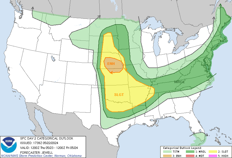
The morning Weather Prediction Center QPF for the next 7 Days and Excessive Rainfall Outlooks continue to be worrisome.
- Attachments
-
-
-
Carla/Alicia/Jerry(In The Eye)/Michelle/Charley/Ivan/Dennis/Katrina/Rita/Wilma/Humberto/Ike/Harvey
Member: National Weather Association
Facebook.com/Weather Infinity
Twitter @WeatherInfinity
Member: National Weather Association
Facebook.com/Weather Infinity
Twitter @WeatherInfinity
-
unome
- Posts: 3062
- Joined: Fri Feb 12, 2010 6:11 pm
West Gulf River Forecast Center - 26 gauges currently in flood, 36 gauges currently forecast forecast to be in flood
https://www.weather.gov/wgrfc/
https://water.weather.gov/ahps/region_f ... ?rfc=wgrfc
https://twitter.com/NWSWGRFC
https://www.facebook.com/NWSWestGulf
https://www.weather.gov/wgrfc/
https://water.weather.gov/ahps/region_f ... ?rfc=wgrfc
https://twitter.com/NWSWGRFC
https://www.facebook.com/NWSWestGulf