
May 2017: Memorial Day/End Of May Outlook
I just saw this article by Blake Mathews on twitter regarding the potential for heavy rain on Memorial Day.
http://www.khou.com/news/local/memorial ... /441937545
I know Blake started as on of us on this board which is why am a bit taken aback by the implications made in his post. It looks as if he is referring to one GFS model run that was 7 days out at the time. We all know to take any model forecast that far out with a grain of salt. Given the feelings many residents around here have now any time heavy rain threatens I personally think it was a bit irresponsible to post that and imply similarities to Memorial Day 2015. Blake, if you see this I do not mean any disrespect to you or your fellow pro-mets at KHOU, I just worry that these kinds of things get the hype machine cranking unnecessarily.
-
houstonia
- Posts: 138
- Joined: Sun Jun 14, 2015 6:51 pm
- Location: Houston, Texas (Southwest side; Sharpstown)
- Contact:
Jeff with the Harris County Flood Control District did make mention of the same time period. I think his point (and maybe Blake's) is that this time of the year, heavy rainfall is a general threat to look out for.sau27 wrote:I just saw this article by Blake Mathews on twitter regarding the potential for heavy rain on Memorial Day.
I know Blake started as on of us on this board which is why am a bit taken aback by the implications made in his post. It looks as if he is referring to one GFS model run that was 7 days out at the time. We all know to take any model forecast that far out with a grain of salt. Given the feelings many residents around here have now any time heavy rain threatens I personally think it was a bit irresponsible to post that and imply similarities to Memorial Day 2015. Blake, if you see this I do not mean any disrespect to you or your fellow pro-mets at KHOU, I just worry that these kinds of things get the hype machine cranking unnecessarily.
Yet another front will slowly advance toward the area on Sunday and Monday and once again looks to stall across the region with several disturbances moving along the boundary. Threat for thunderstorms…some severe…and heavy rainfall may be back in the forecast late Sunday into early next week. This will be something to watch in the coming days as stalling boundaries with pooling moisture this time of year can result in excessive rainfall and we do not have a good track record with Memorial Day Holiday’s and weather in this area.
-
srainhoutx

- Site Admin

- Posts: 19616
- Joined: Tue Feb 02, 2010 2:32 pm
- Location: Maggie Valley, NC
- Contact:
I see the 12Z Texas Tech WRF continues to "sniff out" the potential for some stronger storms early this evening and possibly inching closer to Metro Houston. As Jeff alluded to, the main threat would be large damaging hail and gusty thunderstorm winds primarily along and West of the I-45 Corridor. We will need to monitor trends across the Hill Country this afternoon for potential up growth of storms. I did notice a bit of a gravity wave via visible imagery near Austin that can offer clues as to where storms may attempt to organize as the frontal boundary nears.
Regarding what Jeff and Blake have indicated in their forecasts/outlooks. Typically most people pay little attention to weather worries around big Holiday Weekends. I changed the Topic Title yesterday when I started noticing some general agreement with the reliable ECMWF and GFS solutions suggesting a stalling frontal boundary across the Central and SE Texas areas. While I try to limit any personal bullishness about potential heavy rainfall more than 3 to 5 days out in model world, there is a possibility of pooling deep tropical moisture with its origin in the Western Caribbean creeping back into the Western Gulf around Saturday. With many folks planning outdoor activities for the first summertime Holiday, it is worth monitoring. Let's see how things look later in the week and then I am more than sure that if there is a legitimate concern, we will focus closely on our sensible weather.
Carla/Alicia/Jerry(In The Eye)/Michelle/Charley/Ivan/Dennis/Katrina/Rita/Wilma/Humberto/Ike/Harvey
Member: National Weather Association
Facebook.com/Weather Infinity
Twitter @WeatherInfinity
Member: National Weather Association
Facebook.com/Weather Infinity
Twitter @WeatherInfinity
-
srainhoutx
- Site Admin
- Posts: 19616
- Joined: Tue Feb 02, 2010 2:32 pm
- Location: Maggie Valley, NC
- Contact:
NWS Storm Prediction Center Norman OK
0234 PM CDT Tue May 23 2017
Areas affected...Portions of central TX
Concerning...Severe potential...Watch possible
Valid 231934Z - 232130Z
Probability of Watch Issuance...40 percent
SUMMARY...Some increase in severe potential should occur over the
next several hours, with isolated large hail and damaging winds the
main threats. Watch issuance is possible.
DISCUSSION...19Z surface analysis shows a cold front extending from
northeast to central TX, continuing into west TX. Surface pressure
falls of 2-4 mb per 2 hours across central TX ahead of the front
suggest large-scale ascent attendant to a southeastward-moving
shortwave trough over the southern High Plains is overspreading the
discussion area. Some elevated convection has recently developed
behind the front, likely associated with the shortwave trough. As
these thunderstorms move quickly east-southeastward, they will have
some potential to become surface based. Clearing ahead of the front
has allowed for diurnal heating to destabilize the airmass across
the warm sector of central TX. Latest RAP Mesoanalysis indicates
MLCAPE of 500-1000 J/kg has developed this afternoon. Further
heating may allow MLCAPE values to approach 1500 J/kg through the
peak of the diurnal heating cycle.
Northwesterly low-level winds strengthen with height, supporting
effective bulk shear values of 45-50 kt. Convective coverage and
evolution remains somewhat unclear this afternoon across central TX
and vicinity. But, consensus of short-term guidance points to an
increasing potential for supercell development over the next several
hours along and ahead of the front, with large hail and damaging
winds both possible. Depending on convective trends this afternoon,
watch issuance is possible.
..Gleason/Kerr.. 05/23/2017
...Please see www.spc.noaa.gov for graphic product...
ATTN...WFO...HGX...FWD...EWX...SJT...
Carla/Alicia/Jerry(In The Eye)/Michelle/Charley/Ivan/Dennis/Katrina/Rita/Wilma/Humberto/Ike/Harvey
Member: National Weather Association
Facebook.com/Weather Infinity
Twitter @WeatherInfinity
Member: National Weather Association
Facebook.com/Weather Infinity
Twitter @WeatherInfinity

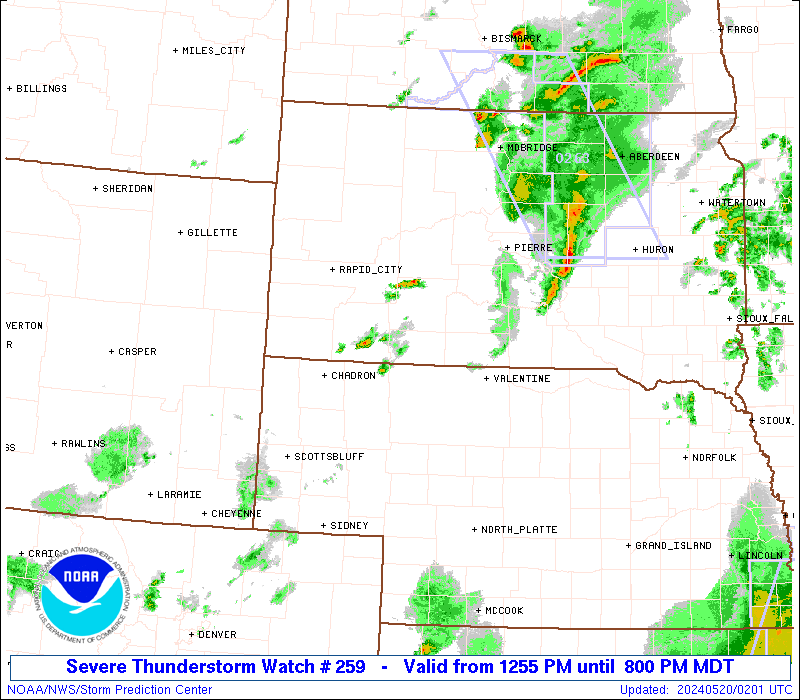
URGENT - IMMEDIATE BROADCAST REQUESTED
Severe Thunderstorm Watch Number 259
NWS Storm Prediction Center Norman OK
330 PM CDT Tue May 23 2017
The NWS Storm Prediction Center has issued a
* Severe Thunderstorm Watch for portions of
central and southeast Texas
* Effective this Tuesday afternoon and evening from 330 PM until
1100 PM CDT.
* Primary threats include...
Scattered large hail and isolated very large hail events to 2
inches in diameter possible
Scattered damaging wind gusts to 70 mph possible
SUMMARY...Scattered thunderstorms now forming across parts of
central Texas are expected to increase in coverage and intensity
while developing eastward and southeastward toward mid and upper
Texas coastal areas through this evening. Strongest activity will
be capable of producing severe hail and potentially damaging surface
gusts.
The severe thunderstorm watch area is approximately along and 80
statute miles north and south of a line from 15 miles southwest of
San Antonio TX to 50 miles south southeast of Tyler TX. For a
complete depiction of the watch see the associated watch outline
update (WOUS64 KWNS WOU9).
PRECAUTIONARY/PREPAREDNESS ACTIONS...
REMEMBER...A Severe Thunderstorm Watch means conditions are
favorable for severe thunderstorms in and close to the watch area.
Persons in these areas should be on the lookout for threatening
weather conditions and listen for later statements and possible
warnings. Severe thunderstorms can and occasionally do produce
tornadoes.

Storm moved incredibly fast - 60 mph through CLL in the last 30 min and approaching NW Harris Co. Fast. Be prepared!

Severe Weather Statement
National Weather Service Houston/Galveston TX
703 PM CDT TUE MAY 23 2017
TXC015-089-157-201-473-481-240030-
/O.CON.KHGX.SV.W.0120.000000T0000Z-170524T0030Z/
Colorado TX-Wharton TX-Austin TX-Fort Bend TX-Waller TX-Harris TX-
703 PM CDT TUE MAY 23 2017
...A SEVERE THUNDERSTORM WARNING REMAINS IN EFFECT UNTIL 730 PM CDT
FOR NORTHEASTERN COLORADO...NORTH CENTRAL WHARTON...EASTERN AUSTIN...
NORTHWESTERN FORT BEND...SOUTHERN WALLER AND WEST CENTRAL HARRIS
COUNTIES...
At 701 PM CDT, a severe thunderstorm was located near Sealy, moving
southeast at 65 mph. Large tree reported down in Frelsburg on FM 109.
HAZARD...60 mph wind gusts and quarter size hail.
SOURCE...Radar indicated.
IMPACT...Hail damage to vehicles is expected. Expect wind damage to
roofs, siding, and trees.
Locations impacted include...
Northwestern Rosenberg, Katy, Sealy, Brookshire, Bellville, Eagle
Lake, southwestern Addicks Park Ten, East Bernard, Wallis, Fulshear,
Simonton, San Felipe, Pattison, Orchard, Cinco Ranch, Weston Lakes,
Egypt, Cat Spring and Hungerford.
PRECAUTIONARY/PREPAREDNESS ACTIONS...
For your protection move to an interior room on the lowest floor of a
building.
Continuous cloud to ground lightning is occurring with this storm.
Move indoors immediately. Lightning is one of nature`s leading
killers. Remember, if you can hear thunder, you are close enough to
be struck by lightning.
&&
LAT...LON 2964 9651 2986 9635 2999 9624 2981 9568
2928 9619
TIME...MOT...LOC 0001Z 309DEG 55KT 2973 9617
HAIL...1.00IN
WIND...60MPH
$$
Hathaway
Severe Thunderstorm Warning
TXC241-457-240100-
/O.NEW.KLCH.SV.W.0116.170524T0001Z-170524T0100Z/
BULLETIN - IMMEDIATE BROADCAST REQUESTED
Severe Thunderstorm Warning
National Weather Service Lake Charles LA
701 PM CDT TUE MAY 23 2017
The National Weather Service in Lake Charles has issued a
* Severe Thunderstorm Warning for...
Central Tyler County in southeastern Texas...
Northeastern Jasper County in southeastern Texas...
* Until 800 PM CDT
* At 700 PM CDT, severe thunderstorms were located along a line
extending from 7 miles northwest of Woodville to near Ebenezer,
moving east at 25 mph.
HAZARD...60 mph wind gusts and quarter size hail.
SOURCE...Radar indicated.
IMPACT...Hail damage to vehicles is expected. Expect wind damage
to roofs, siding, and trees.
* Locations impacted include...
Jasper, Woodville, Town Bluff, Ivanhoe and Hillister.
PRECAUTIONARY/PREPAREDNESS ACTIONS...
For your protection move to an interior room on the lowest floor of a
building.
&&
LAT...LON 3102 9412 3083 9388 3061 9443 3073 9459
3083 9462
TIME...MOT...LOC 0000Z 285DEG 22KT 3082 9454 3096 9415
HAIL...1.00IN
WIND...60MPH
$$
06
Coming down really hard in Stafford, wind was whipping up for a bit. But skies look to be clearing a bit.
2 inches (in the rain gauge) in 10 minutes. Flooded yard, and tons of lightning on the south side of Pearland. Not a whole lot of wind or hail imby though.
-
ccbluewater
- Posts: 64
- Joined: Tue May 23, 2017 1:16 pm
- Location: Cypress
- Contact:
Long time lurker, but first time poster. Thanks to all that make this board great!
I'm in Cypress, South of 290, and this entire event we have probably barely got .10". Pretty frustrating to watch the rains split around us time after time. Hoping we can catch some meaningful rain with the late weekend system, just not what we have seen the past 2 Memorial Day weekends!
I'm in Cypress, South of 290, and this entire event we have probably barely got .10". Pretty frustrating to watch the rains split around us time after time. Hoping we can catch some meaningful rain with the late weekend system, just not what we have seen the past 2 Memorial Day weekends!
Looks like a new, small line is south of Bastrop to Lockhart and heading our way.
-
srainhoutx
- Site Admin
- Posts: 19616
- Joined: Tue Feb 02, 2010 2:32 pm
- Location: Maggie Valley, NC
- Contact:
Rather chilly up here in NW Harris County this morning. The weather station is showing 56F!. Enjoy the next few days of cool and drier weather with low dewpoints. It's been a while since we've seen morning lows this cool in late May.
Carla/Alicia/Jerry(In The Eye)/Michelle/Charley/Ivan/Dennis/Katrina/Rita/Wilma/Humberto/Ike/Harvey
Member: National Weather Association
Facebook.com/Weather Infinity
Twitter @WeatherInfinity
Member: National Weather Association
Facebook.com/Weather Infinity
Twitter @WeatherInfinity
-
tireman4

- Global Moderator

- Posts: 4488
- Joined: Wed Feb 03, 2010 9:24 pm
- Location: Humble, Texas
- Contact:
As per the conversation yesterday about Memorial Day.
000
FXUS64 KHGX 240914
AFDHGX
Area Forecast Discussion
National Weather Service Houston/Galveston TX
414 AM CDT Wed May 24 2017
.DISCUSSION...
A much quieter morning across SE TX. The last line of convection
(likely associated with the 85H front) has moved off to the E/SE
and skies are clear across the CWA. Main forecast issue looks to
be temps these next few days given the moderate/weak CAA develop-
ing in the wake of the front. Lower/mid 80s max temps should pre-
vail this afternoon with lows tonight in the lower 60s inland to
the lower 70s along the coast. Warmer temps expected by the week-
end with low 90s possible starting Fri afternoon.
The upper ridging over the region (today/Thu) will be flattening
by Fri as the main low/trof moves off the NE coast. The building
ridge over the west coast will help maintain the zonal flow over
the state through the weekend. The return of onshore winds along
with Gulf moisture could produce some isolated showers along the
coast late Sat night, but the main focus should be further north
as a weak cold front moves down from the Southern Plains. Models
have been indicating that this boundary could be the focus for a
period of wet/active weather for SE TX beginning Sun night on in-
to perhaps the middle of next week as a series of shortwaves app-
roach from the west. (That this time frame does include Memorial
Day has been duly noted.) For now will stay with with 30-40 POPS
for this part of the forecast...as we wait and see how the later
runs resolve things. 41
&&
.MARINE...
Elevated northerly winds will gradually weaken throughout the
morning. A Small Craft Advisory is in effect until 5 AM, and small
craft should exercise caution until 10 AM. Onshore winds will
return early Thursday and quickly strengthen during the day as the
gradient tightens.Elevated winds and seas can be expected from the
end of the week on through the upcoming Memorial Day weekend.
Caution flags will probably be needed, and advisories will be
possible. 11
&&
.AVIATION...
VFR conditions are expected throughout the taf period. NW winds may
become gusty during the day today before gradually becoming onshore
overnight tonight. 11
&&
.PRELIMINARY POINT TEMPS/POPS...
College Station (CLL) 82 62 90 74 91 / 10 0 0 10 10
Houston (IAH) 82 62 88 74 89 / 10 0 0 0 10
Galveston (GLS) 82 71 84 78 86 / 10 0 0 0 10
&&
.HGX WATCHES/WARNINGS/ADVISORIES...
TX...NONE.
GM...Small Craft Advisory until 5 AM CDT early this morning for the
following zones: Coastal waters from Freeport to the
Matagorda Ship Channel out 20 NM...Coastal waters from High
Island to Freeport out 20 NM...Galveston Bay...Matagorda
Bay...Waters from Freeport to the Matagorda Ship Channel
from 20 to 60 NM...Waters from High Island to Freeport from
20 to 60 NM.
SMALL CRAFT SHOULD EXERCISE CAUTION until 10 AM CDT this morning
for the following zones: Coastal waters from Freeport to
the Matagorda Ship Channel out 20 NM...Coastal waters from
High Island to Freeport out 20 NM...Galveston Bay...
Matagorda Bay...Waters from Freeport to the Matagorda Ship
Channel from 20 to 60 NM...Waters from High Island to
Freeport from 20 to 60 NM.
&&
$$
Discussion...99
First post here but long time reader. Have any of the meteorologist on here seen any signs or heard reports of a possible tornado in western/central Austin County yesterday evening when the storm went through? My parents live near Cat Spring and lost 20+ trees including 24"-30" oaks that were just sheared off or toppled over. I saw some reports in the warnings being posted here of 60 mph straight line winds but I don't think that's enough wind to cause this kind of wide spread damage. Thanks for any help.
Oh and as a Cypress resident I watched that storm split an go around us like almost every other storm we have gotten over the past month or so. We could use more rain but at least we didn't get the severe stuff.
Oh and as a Cypress resident I watched that storm split an go around us like almost every other storm we have gotten over the past month or so. We could use more rain but at least we didn't get the severe stuff.
-
srainhoutx
- Site Admin
- Posts: 19616
- Joined: Tue Feb 02, 2010 2:32 pm
- Location: Maggie Valley, NC
- Contact:
Welcome JGsGN. We are glad you have joined us!. There was some damage in Sealy (Austin County) yesterday afternoon and the day shift at our National Weather Service office in Houston/Galveston will determine if they are going out to survey the damage to see if it was straight line winds or a tornado.JDsGN wrote:First post here but long time reader. Have any of the meteorologist on here seen any signs or heard reports of a possible tornado in western/central Austin County yesterday evening when the storm went through? My parents live near Cat Spring and lost 20+ trees including 24"-30" oaks that were just sheared off or toppled over. I saw some reports in the warnings being posted here of 60 mph straight line winds but I don't think that's enough wind to cause this kind of wide spread damage. Thanks for any help.
Oh and as a Cypress resident I watched that storm split an go around us like almost every other storm we have gotten over the past month or so. We could use more rain but at least we didn't get the severe stuff.
Carla/Alicia/Jerry(In The Eye)/Michelle/Charley/Ivan/Dennis/Katrina/Rita/Wilma/Humberto/Ike/Harvey
Member: National Weather Association
Facebook.com/Weather Infinity
Twitter @WeatherInfinity
Member: National Weather Association
Facebook.com/Weather Infinity
Twitter @WeatherInfinity
Thank you for the quick reply and the daily updates as they are very much appreciated.srainhoutx wrote:Welcome JGsGN. We are glad you have joined us!. There was some damage in Sealy (Austin County) yesterday afternoon and the day shift at our National Weather Service office in Houston/Galveston will determine if they are going out to survey the damage to see if it was straight line winds or a tornado.JDsGN wrote:First post here but long time reader. Have any of the meteorologist on here seen any signs or heard reports of a possible tornado in western/central Austin County yesterday evening when the storm went through? My parents live near Cat Spring and lost 20+ trees including 24"-30" oaks that were just sheared off or toppled over. I saw some reports in the warnings being posted here of 60 mph straight line winds but I don't think that's enough wind to cause this kind of wide spread damage. Thanks for any help.
Oh and as a Cypress resident I watched that storm split an go around us like almost every other storm we have gotten over the past month or so. We could use more rain but at least we didn't get the severe stuff.
-
CrashTestDummy
- Posts: 187
- Joined: Mon Jul 25, 2016 3:44 pm
- Location: Pearland, Texas
- Contact:
I'll bet they do. Sealy ISD is closed today, and ~20% of Austin Co is still w/o power.srainhoutx wrote:Welcome JGsGN. We are glad you have joined us!. There was some damage in Sealy (Austin County) yesterday afternoon and the day shift at our National Weather Service office in Houston/Galveston will determine if they are going out to survey the damage to see if it was straight line winds or a tornado.JDsGN wrote:First post here but long time reader. Have any of the meteorologist on here seen any signs or heard reports of a possible tornado in western/central Austin County yesterday evening when the storm went through? My parents live near Cat Spring and lost 20+ trees including 24"-30" oaks that were just sheared off or toppled over. I saw some reports in the warnings being posted here of 60 mph straight line winds but I don't think that's enough wind to cause this kind of wide spread damage. Thanks for any help.
Oh and as a Cypress resident I watched that storm split an go around us like almost every other storm we have gotten over the past month or so. We could use more rain but at least we didn't get the severe stuff.
And yeah, a couple of years ago we seemed to have a situation in the northern Brazoria County area where we were very dry, and as the weather started getting moist, it seemed every line of t-storms would split and pass either side of us like we were inside a great column of dryness. It was frustrating for a couple of months!
Gene Beaird,
Pearland, Texas
"You can learn a lot from a Dummy."
Pearland, Texas
"You can learn a lot from a Dummy."