

Long Range Model Thread.
-
srainhoutx

- Site Admin

- Posts: 19616
- Joined: Tue Feb 02, 2010 2:32 pm
- Location: Maggie Valley, NC
- Contact:
Hmmm...this is not 92L...
Carla/Alicia/Jerry(In The Eye)/Michelle/Charley/Ivan/Dennis/Katrina/Rita/Wilma/Humberto/Ike/Harvey
Member: National Weather Association
Facebook.com/Weather Infinity
Twitter @WeatherInfinity
Member: National Weather Association
Facebook.com/Weather Infinity
Twitter @WeatherInfinity
-
srainhoutx
- Site Admin
- Posts: 19616
- Joined: Tue Feb 02, 2010 2:32 pm
- Location: Maggie Valley, NC
- Contact:
Here is the 12Z EC from Allen's site...

Carla/Alicia/Jerry(In The Eye)/Michelle/Charley/Ivan/Dennis/Katrina/Rita/Wilma/Humberto/Ike/Harvey
Member: National Weather Association
Facebook.com/Weather Infinity
Twitter @WeatherInfinity
Member: National Weather Association
Facebook.com/Weather Infinity
Twitter @WeatherInfinity

http://raleighwx.easternuswx.com/models.htmlEd Mahmoud wrote: RaleighWx- I gotta find that and bookmark it...
-
srainhoutx
- Site Admin
- Posts: 19616
- Joined: Tue Feb 02, 2010 2:32 pm
- Location: Maggie Valley, NC
- Contact:
This actually has been showing up for several days in varying strength. With the 00Z run last night the 850 vort has increased each run. We need to keep an eye on this as Upper Air pattern is becoming favorable and lower pressures as well a favorable MJO pulse are all coming together to what may prove to be an interesting development. We shall see if this is a model fantasy or not. Regardless things are moving to a somewhat more favorable pattern for development in the Western Caribbean/GOM regions.
Carla/Alicia/Jerry(In The Eye)/Michelle/Charley/Ivan/Dennis/Katrina/Rita/Wilma/Humberto/Ike/Harvey
Member: National Weather Association
Facebook.com/Weather Infinity
Twitter @WeatherInfinity
Member: National Weather Association
Facebook.com/Weather Infinity
Twitter @WeatherInfinity
Oh YUCK....DISLIKE...DISLIKE...DISLIKE!!!!
Euro continues to show a feature similar to the GFS though a bit quicker with it. Extremely long range but interesting that both have it in some fashion.

That's why I put it in here and not the 92l thread.Ed Mahmoud wrote:I don't think that is the late 92L, but I can't tell for sure. Near miss for Deep South Texas, it looks like...Scott747 wrote:Euro continues to show a feature similar to the GFS though a bit quicker with it. Extremely long range but interesting that both have it in some fashion.
]
Looks like it's developed from a wave near the Bahamas, crossing over the Straits and into the GOM.
Hopefully that's not the case as we don't need anything hindering the relief wells right now. One is close to depth and it would be great if they can finish up before any activity forces a temporary shutdown.

12z European model looks pretty nasty for the Texas coast...


-
srainhoutx
- Site Admin
- Posts: 19616
- Joined: Tue Feb 02, 2010 2:32 pm
- Location: Maggie Valley, NC
- Contact:
The big question is will the Upper Ridge hold? It is note worthy that the ECMWF has been rather persistent with this feature. Although today things have shifted a bit N from the overnight run. HPC thoughts this afternoon...snippet...
EXTENDED FORECAST DISCUSSION
NWS HYDROMETEOROLOGICAL PREDICTION CENTER CAMP SPRINGS MD
211 PM EDT SUN JUN 20 2010
VALID 12Z WED JUN 23 2010 - 12Z SUN JUN 27 2010
SOUTHERN PLAINS/LOWER MS VALLEY/SOUTHEAST/GULF OF MEXICO...
THE MODELS STILL INDICATE A STRONG AND SPRAWLING ANTICYCLONE
STARTING ON DAY THREE. 850 MB TEMPERATURES AND 500 MB HEIGHTS
RANGE FROM 1-2 STANDARD DEVIATIONS ABOVE NORMAL...SO HOT
CONDITIONS ARE LIKELY ACROSS THE REGION. THERE DOES NOT APPEAR TO
BE A SIGN OF ANY FEATURE TO DISLODGE THE SPRAWLING
ANTICYCLONE...WHICH SHOULD REMAIN IN PLACE EVEN BEYOND DAY
SEVEN/SUN 27 JUN.
AT LOWER LATITUDES... PATTERN WILL BE FAVORABLE FOR PROGRESSION OF
ONE OR MORE TROPICAL WAVES ACROSS THE CARIBBEAN/GULF OF MEXICO AND
POSSIBLY BRUSHING THE FLORIDA PENINSULA/KEYS IN THE PROCESS.
THERE IS POTENTIAL FOR A DISTURBANCE IN THE NORTHWEST
CARIBBEAN/SOUTHERN GULF OF MEXICO/YUCATAN PENINSULA DAYS SIX-SEVEN
SAT 26 JUN TO SUN 27 JUN...AS SHOWN IN MOST OF THE ECMWF ENSEMBLE
MEMBERS.
PETERSEN/RAUSCH
Carla/Alicia/Jerry(In The Eye)/Michelle/Charley/Ivan/Dennis/Katrina/Rita/Wilma/Humberto/Ike/Harvey
Member: National Weather Association
Facebook.com/Weather Infinity
Twitter @WeatherInfinity
Member: National Weather Association
Facebook.com/Weather Infinity
Twitter @WeatherInfinity
HGX:
LONG RANGE PROGS (WHILE STILL SHAKY IN TERMS OF CONSISTENCY) REMAIN ON
COURSE WITH THE POSSIBLE DEVELOPMENT OF A TROPICAL SOMETHING THAT
COULD APPROACH THE TX COAST LINE AOA THE MIDDLE OF NEXT WEEK. BUT
HAVING SAID THAT...THERE IS STILL QUITE A LOT OF TIME BETWEEN NOW
AND THEN AND A LOT MORE MODEL RUNS LEFT TO RUN. SO NOT QUITE BEAR
WATCHING TIME YET. 41
-
srainhoutx
- Site Admin
- Posts: 19616
- Joined: Tue Feb 02, 2010 2:32 pm
- Location: Maggie Valley, NC
- Contact:
I suspect if this trend continues, we will need a new thread. The GFS is suggesting lowering shear as well as lowering pressures. ECMWF ensembles have been sniffing this out for several days as well.
Carla/Alicia/Jerry(In The Eye)/Michelle/Charley/Ivan/Dennis/Katrina/Rita/Wilma/Humberto/Ike/Harvey
Member: National Weather Association
Facebook.com/Weather Infinity
Twitter @WeatherInfinity
Member: National Weather Association
Facebook.com/Weather Infinity
Twitter @WeatherInfinity
One thing of note that might throw a few folks off guard. Middle of next week is about 10 days away. Sometimes when people see a statement like that over the weekend they are thinking shorter term. Plenty of time to watch this play out as HGX noted and we should begin to see come activity in the Caribbean begin to take hold as the week progresses if the Euro is really on to something.Mr. T wrote:HGX:
LONG RANGE PROGS (WHILE STILL SHAKY IN TERMS OF CONSISTENCY) REMAIN ON
COURSE WITH THE POSSIBLE DEVELOPMENT OF A TROPICAL SOMETHING THAT
COULD APPROACH THE TX COAST LINE AOA THE MIDDLE OF NEXT WEEK. BUT
HAVING SAID THAT...THERE IS STILL QUITE A LOT OF TIME BETWEEN NOW
AND THEN AND A LOT MORE MODEL RUNS LEFT TO RUN. SO NOT QUITE BEAR
WATCHING TIME YET. 41
-
srainhoutx
- Site Admin
- Posts: 19616
- Joined: Tue Feb 02, 2010 2:32 pm
- Location: Maggie Valley, NC
- Contact:

Carla/Alicia/Jerry(In The Eye)/Michelle/Charley/Ivan/Dennis/Katrina/Rita/Wilma/Humberto/Ike/Harvey
Member: National Weather Association
Facebook.com/Weather Infinity
Twitter @WeatherInfinity
Member: National Weather Association
Facebook.com/Weather Infinity
Twitter @WeatherInfinity
Heres an interesting incerpt from the Austin/San Antonio NWS
THE UPPER HIGH IS FORECAST TO SHIFT EAST TO
OVER THE DEEP SOUTH BY LATE NEXT WEEKEND...OPENING UP A PATH FROM
THE CARIBBEAN INTO THE SOUTHERN GULF FOR ANY TROPICAL WAVES OR
TROPICAL CYCLONES THAT EXIST AT THAT TIME. THE 12Z ECMWF WAS
RATHER AGGRESSIVE IN DEVELOPING A TROPICAL CYCLONE OVER THE
SOUTH CENTRAL GULF LATE IN THE FORECAST CYCLE...THEN MOVING IT
INTO THE COASTAL BEND AT 228H. THE PREVIOUS RUN OF THE ECMWF ALSO
SHOWED THE POTENTIAL FOR TC DEVELOPMENT. THIS TREND IS WORTHY OF
NOTE GIVEN THAT YESTERDAY`S 12Z RUN OF THE GFS WAS SHOWING THIS
POTENTIAL AS WELL. THE THEME HERE IS INCREASING CONFIDENCE OF THE
GULF BECOMING A FAVORABLE AREA FOR TC DEVELOPMENT/MOVEMENT NEXT
WEEKEND
-
srainhoutx
- Site Admin
- Posts: 19616
- Joined: Tue Feb 02, 2010 2:32 pm
- Location: Maggie Valley, NC
- Contact:
GFS shear tendency forecast...

Carla/Alicia/Jerry(In The Eye)/Michelle/Charley/Ivan/Dennis/Katrina/Rita/Wilma/Humberto/Ike/Harvey
Member: National Weather Association
Facebook.com/Weather Infinity
Twitter @WeatherInfinity
Member: National Weather Association
Facebook.com/Weather Infinity
Twitter @WeatherInfinity
-
srainhoutx
- Site Admin
- Posts: 19616
- Joined: Tue Feb 02, 2010 2:32 pm
- Location: Maggie Valley, NC
- Contact:
HPC:
day 6

day 7

day 6
day 7
Carla/Alicia/Jerry(In The Eye)/Michelle/Charley/Ivan/Dennis/Katrina/Rita/Wilma/Humberto/Ike/Harvey
Member: National Weather Association
Facebook.com/Weather Infinity
Twitter @WeatherInfinity
Member: National Weather Association
Facebook.com/Weather Infinity
Twitter @WeatherInfinity
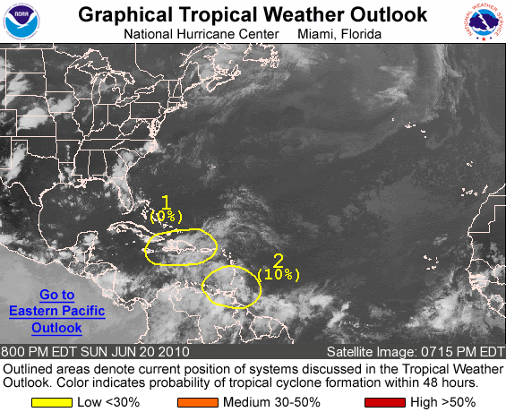
2. ANOTHER TROPICAL WAVE LOCATED OVER THE SOUTHEASTERN CARIBBEAN SEA IS
PRODUCING WIDESPREAD CLOUDINESS AND SHOWERS OVER MUCH OF THE
WINDWARD ISLANDS AND NORTHEASTERN VENEZUELA...AND ADJACENT WATERS
OF THE CARIBBEAN SEA AND SOUTHWESTERN ATLANTIC. THIS SYSTEM WILL
PRODUCE LOCALLY HEAVY RAINFALL AND GUSTY WINDS ACROSS THE WINDWARD
ISLANDS AND NORTHERN VENEZUELA DURING THE NEXT DAY OR SO AS THE
WAVE MOVES WEST-NORTHWESTWARD AT 10 TO 15 MPH. UPPER-LEVEL WINDS
ARE ONLY MARGINALLY CONDUCIVE FOR TROPICAL CYCLONE DEVELOPMENT...
AND THERE IS A LOW CHANCE...10 PERCENT...OF THIS SYSTEM BECOMING A
TROPICAL CYCLONE DURING THE NEXT 48 HOURS.
That is the system that the Euro/CMC/Nogaps develop...
-
srainhoutx
- Site Admin
- Posts: 19616
- Joined: Tue Feb 02, 2010 2:32 pm
- Location: Maggie Valley, NC
- Contact:
Mr. T wrote:2. ANOTHER TROPICAL WAVE LOCATED OVER THE SOUTHEASTERN CARIBBEAN SEA IS
PRODUCING WIDESPREAD CLOUDINESS AND SHOWERS OVER MUCH OF THE
WINDWARD ISLANDS AND NORTHEASTERN VENEZUELA...AND ADJACENT WATERS
OF THE CARIBBEAN SEA AND SOUTHWESTERN ATLANTIC. THIS SYSTEM WILL
PRODUCE LOCALLY HEAVY RAINFALL AND GUSTY WINDS ACROSS THE WINDWARD
ISLANDS AND NORTHERN VENEZUELA DURING THE NEXT DAY OR SO AS THE
WAVE MOVES WEST-NORTHWESTWARD AT 10 TO 15 MPH. UPPER-LEVEL WINDS
ARE ONLY MARGINALLY CONDUCIVE FOR TROPICAL CYCLONE DEVELOPMENT...
AND THERE IS A LOW CHANCE...10 PERCENT...OF THIS SYSTEM BECOMING A
TROPICAL CYCLONE DURING THE NEXT 48 HOURS.
That is the system that the Euro/CMC/Nogaps develop...
Carla/Alicia/Jerry(In The Eye)/Michelle/Charley/Ivan/Dennis/Katrina/Rita/Wilma/Humberto/Ike/Harvey
Member: National Weather Association
Facebook.com/Weather Infinity
Twitter @WeatherInfinity
Member: National Weather Association
Facebook.com/Weather Infinity
Twitter @WeatherInfinity

I agree Tyler the wave that was just mentioned in the TWO is the one to watch. The EURO, GFS, CMC have been sniffing something all week. I thought at first it might have been 92L but this is not the case. I do not like the EURO showing this so early in the season....sheesh we are still in June.
Up to 20% chance of development...

1. A TROPICAL WAVE OVER THE EASTERN CARIBBEAN SEA IS PRODUCING A LARGE
AREA OF DISORGANIZED CLOUDINESS...SHOWERS...AND THUNDERSTORMS OVER
THE EASTERN CARIBBEAN AND THE ADJACENT LAND AREAS. THIS SYSTEM
COULD PRODUCE LOCALLY HEAVY RAINFALL AND GUSTY WINDS OVER PORTIONS
OF NORTHERN VENEZUELA...THE LESSER ANTILLES...THE VIRGIN ISLANDS
AND PUERTO RICO DURING THE NEXT COUPLE OF DAYS AS IT MOVES WEST-
NORTHWESTWARD AT 10 TO 15 MPH. SURFACE PRESSURES ARE NOT FALLING
SIGNIFICANTLY OVER THE AREA AND THERE IS A LOW CHANCE...20
PERCENT...OF THIS SYSTEM BECOMING A TROPICAL CYCLONE DURING THE
NEXT 48 HOURS.