
I'm not a 2k junkie although i've been a member for years, i'm not at all surprised that it has probably crashed again.Paul wrote:BTW- for you 2k junkies out there the site is down.....ED this was not directed to you...you are banned to that famous site Eastern....
INVEST 92L
-
wxman57

- Global Moderator

- Posts: 2621
- Joined: Thu Feb 04, 2010 5:34 am
- Location: Southwest Houston (Westbury)
- Contact:
The GFDL is no longer being updated/changed. All work is focused on its replacement, the HWRF now. I saw several sessions on the various models at the recent AMS tropical conference in Tucson. HWRF is close to matching GFDL now, and its intensity calculations were modified for 2010. Hindcast studies indicate improvement with HWRF's intensity forecasts.Paul wrote:I never put to much stock in the HWRF...wasn't it supposed to replace the GFDL at one point....they always overdo the intensity and very erratic with track....wxman57 wrote:Good link Ptarmigan posted to Ryan Maue's site with HWRF models. I traced the link back and found an animation of the 12Z run:
http://www.coaps.fsu.edu/~maue/extreme/ ... _anim.html
Note that the next runs will have a different URL, but you can just edit the URL to put in the correct date/time group in the 2 places. Also note that winds in the model run are at 900mb not the surface. That's probably around the peak wind height of a TC, so there would be some reduction needed to bring them to the surface, maybe 70%.
-
Katdaddy

- Global Moderator
- Posts: 2502
- Joined: Thu Feb 04, 2010 8:18 am
- Location: League City, Tx
- Contact:
A good read from the San Juan AFD regarding Invest 92L:
AREA FORECAST DISCUSSION
NATIONAL WEATHER SERVICE SAN JUAN PR
327 PM AST SUN JUN 13 2010
.SYNOPSIS...MID-UPPER LVL RIDGE WILL DOMINATE THE REGION THROUGH TUE.
UPPER TROUGH ACROSS THE CNTRL ATLC IS FCST TO RETROGRESS WITH A
SHEAR AXIS FCST TO DEVELOP OVR THE AREA MID WEEK. BROAD AREA OF
LOW PRES ACROSS THE CNTRL ATLC COULD BECOME THE FIRST NAMED STORM
OF THE 2010 HURRICANE SEASON.
&&
.DISCUSSION...AZORES-BERMUDA HIGH WILL MAINTAIN A FRESH TRADE
WIND FLOW ACROSS THE CARIBBEAN THROUGH MUCH OF THE WEEK. MODELS
MAINTAIN A RELATIVELY DRY AIR MASS THROUGH MUCH OF THE WORK WEEK
WITH PWAT VALUES AROUND 1.5-1.75 INCHES. EVEN SO AFTERNOON
CONVECTION WILL STILL BE POSSIBLE EACH DAY ACROSS WRN PR DUE TO
SEA BREEZE CONVERGENCE AND INTENSE HEATING.
BROAD AREA OF LOW PRES ACROSS THE CNTRL ATLC ALONG 37W IS BECOMING
BETTER ORGANIZED AND APPEARS THIS SYSTEM HAS A VERY GOOD CHANCE IN
BECOMING THE FIRST NAMED STORM OF THE 2010 HURRICANE SEASON. THIS
SYSTEM IS EXPECTED TO TRACK WNW OVR THE NEXT SVRL DAYS WITH MODEL
GUIDANCE INDICATING THIS SYSTEM ENCOUNTERING STRONG SHEAR AS IT
APPROACHES THE WINDWARD ISLANDS LATER IN THE WEEK. 12Z ECMWF AND
CANADIAN GLOBAL MODELS SEEM TO HAVE THE BEST HANDLE ON THIS
DEVELOPING CYCLONE AND BRING THE SYSTEM CLOSE TO THE REGION SAT BUT
AS AN OPEN WAVE. MAIN EFFECT FROM THIS SYSTEM LOOKS TO BE TORRENTIAL
RAINFALL. SO RIGHT NOW IT LOOKS LIKE NEXT WEEKEND COULD BE WET BUT
THIS IS HIGHLY DEPENDENT ON THE TRACK OF THE STORM WHICH HAS YET
TO FORM. GIVEN GOOD TRACK RECORD OF EUROPEAN MODEL WITH TROPICAL
CYCLONES OVER THE LAST FEW YEARS IT APPEARS WILL SEE INCREASING
CHANCES FOR WIDESPREAD RAINFALL NEXT WEEKEND. REGARDLESS OF
WHETHER THIS STORM FORMS OR NOT...BOTTOMLINE IS THAT CONDITIONS IN
THE TROP ATLC ARE ALREADY FAVORABLE FOR TROPICAL CYCLONE FORMATION
AND PEOPLE SHOULD GO OVER THEIR EMERGENCY PLANS AND BE READY FOR
THE NEXT TROPICAL CYCLONE THREAT NO MATTER WHEN IT MIGHT COMING
KNOCKING ON THE DOOR.
This has to be a major crash of S2K as it has been over 4 hours that it occured until now. Hopefully,the admins there can fix it soon.
Here is a great image that I got from another board.

Here is a great image that I got from another board.
-
desiredwxgd

- Posts: 125
- Joined: Wed Feb 03, 2010 6:30 pm
- Location: TX/LA/Southern New England
- Contact:
JMS
SR. ENSC.
SR. ENSC.
Just viewed a video on accuweather, JB thinks 92L will develop further and end up in the carribean in the coming days.

-
wxman57
- Global Moderator
- Posts: 2621
- Joined: Thu Feb 04, 2010 5:34 am
- Location: Southwest Houston (Westbury)
- Contact:
NHC increased chances to 60% this evening. Seems reasonable, if not maybe low. Agree with Dr. Masters' take on the wind shear and its impact on 92L. JB isn't even mentioning the shear in his video. He's sort of like the Canadian model in many ways.
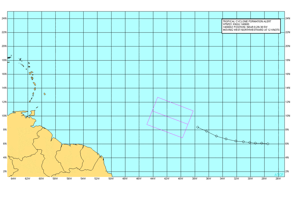
TROPICAL WEATHER OUTLOOK
NWS TPC/NATIONAL HURRICANE CENTER MIAMI FL
800 PM EDT SUN JUN 13 2010
FOR THE NORTH ATLANTIC...CARIBBEAN SEA AND THE GULF OF MEXICO...
A LARGE LOW PRESSURE SYSTEM LOCATED ABOUT 975 MILES WEST-SOUTHWEST
OF THE CAPE VERDE ISLANDS IS PRODUCING WIDESPREAD CLOUDINESS ALONG
WITH SOME SHOWERS AND THUNDERSTORMS. THIS DISTURBANCE CONTINUES TO
BE WELL-ORGANIZED AND ENVIRONMENTAL CONDITIONS ARE EXPECTED TO
REMAIN CONDUCIVE FOR ADDITIONAL DEVELOPMENT OF THIS SYSTEM AS IT
MOVES WEST-NORTHWESTWARD OR NORTHWESTWARD AT 10 TO 15 MPH. THERE IS
A HIGH CHANCE...60 PERCENT...OF THIS SYSTEM BECOMING A TROPICAL
CYCLONE DURING THE NEXT 48 HOURS.
ELSEWHERE...TROPICAL CYCLONE FORMATION IS NOT EXPECTED DURING THE
NEXT 48 HOURS.
$$
FORECASTER STEWART/BLAKE
-
srainhoutx

- Site Admin

- Posts: 19616
- Joined: Tue Feb 02, 2010 2:32 pm
- Location: Maggie Valley, NC
- Contact:

Carla/Alicia/Jerry(In The Eye)/Michelle/Charley/Ivan/Dennis/Katrina/Rita/Wilma/Humberto/Ike/Harvey
Member: National Weather Association
Facebook.com/Weather Infinity
Twitter @WeatherInfinity
Member: National Weather Association
Facebook.com/Weather Infinity
Twitter @WeatherInfinity

JB thinking under PR....thats the only spot I could see this surviving....
looks like cold tops to me...
looks like cold tops to me...
-
wxman57
- Global Moderator
- Posts: 2621
- Joined: Thu Feb 04, 2010 5:34 am
- Location: Southwest Houston (Westbury)
- Contact:
Those cold tops are about 150 miles north of the center, though. Check out the shear barricade across the NE Caribbean (lower left panel):Paul wrote:JB thinking under PR....thats the only spot I could see this surviving....
looks like cold tops to me...

come on Ed id D-min right now...let the sun come up in a few hours and see what happens....
18Z GFDL decapitates it... HWRF, CMC, NOGAPS all keep it a weak TD or TS.....
18Z GFDL decapitates it... HWRF, CMC, NOGAPS all keep it a weak TD or TS.....

Today is the last chance for this thing to develop into a tropical storm, as it is about to be ripped to shreds in the coming days... The Gulf of Mexico and Caribbean remain hostile enviroments and will continue to be so for a while.
Just a quick look at satellite imagery and you can clearly see the high amounts of westerly shear east of the Windward Islands that 92L is about to take a little trip through...
The only "exciting" thing that will come about with this is the fact that development in this region during June is very rare... It will definitely be interesting if this achieves TS status later today.
I agree that the shear is going to be a problem for 92L, but folks what bothers me is the fact that a storm may form in the far east atlantic in the middle of June. That shear will soon be a non issue.By the way take a look behind 92L.
.
.
-
srainhoutx
- Site Admin
- Posts: 19616
- Joined: Tue Feb 02, 2010 2:32 pm
- Location: Maggie Valley, NC
- Contact:
12 UTC intensity guidance suggests slow and steady increase as things move forward...
WHXX01 KWBC 141241
CHGHUR
TROPICAL CYCLONE GUIDANCE MESSAGE
NWS TPC/NATIONAL HURRICANE CENTER MIAMI FL
1241 UTC MON JUN 14 2010
DISCLAIMER...NUMERICAL MODELS ARE SUBJECT TO LARGE ERRORS.
PLEASE REFER TO NHC OFFICIAL FORECASTS FOR TROPICAL CYCLONE
AND SUBTROPICAL CYCLONE INFORMATION.
ATLANTIC OBJECTIVE AIDS FOR
DISTURBANCE INVEST (AL922010) 20100614 1200 UTC
...00 HRS... ...12 HRS... ...24 HRS. .. ...36 HRS...
100614 1200 100615 0000 100615 1200 100616 0000
LAT LON LAT LON LAT LON LAT LON
BAMS 9.7N 39.9W 10.7N 42.6W 11.3N 45.7W 12.0N 48.7W
BAMD 9.7N 39.9W 10.8N 42.7W 11.7N 45.3W 12.7N 47.5W
BAMM 9.7N 39.9W 10.6N 42.6W 11.5N 45.3W 12.3N 47.9W
LBAR 9.7N 39.9W 11.3N 42.4W 12.9N 45.1W 14.4N 47.6W
SHIP 25KTS 31KTS 37KTS 41KTS
DSHP 25KTS 31KTS 37KTS 41KTS
...48 HRS... ...72 HRS... ...96 HRS. .. ..120 HRS...
100616 1200 100617 1200 100618 1200 100619 1200
LAT LON LAT LON LAT LON LAT LON
BAMS 12.6N 51.7W 13.3N 57.6W 14.1N 63.6W 14.9N 69.3W
BAMD 13.6N 49.3W 14.5N 52.4W 14.7N 55.8W 14.6N 60.0W
BAMM 12.9N 50.5W 13.4N 55.7W 13.8N 61.1W 14.2N 66.6W
LBAR 15.8N 49.8W 18.4N 52.9W 21.1N 54.7W 21.7N 55.9W
SHIP 44KTS 46KTS 49KTS 52KTS
DSHP 44KTS 46KTS 49KTS 52KTS
...INITIAL CONDITIONS...
LATCUR = 9.7N LONCUR = 39.9W DIRCUR = 300DEG SPDCUR = 14KT
LATM12 = 8.4N LONM12 = 37.6W DIRM12 = 298DEG SPDM12 = 14KT
LATM24 = 7.1N LONM24 = 34.9W
WNDCUR = 25KT RMAXWD = 60NM WNDM12 = 25KT
CENPRS = 1011MB OUTPRS = 1014MB OUTRAD = 225NM SDEPTH = D
RD34NE = 0NM RD34SE = 0NM RD34SW = 0NM RD34NW = 0NM
Carla/Alicia/Jerry(In The Eye)/Michelle/Charley/Ivan/Dennis/Katrina/Rita/Wilma/Humberto/Ike/Harvey
Member: National Weather Association
Facebook.com/Weather Infinity
Twitter @WeatherInfinity
Member: National Weather Association
Facebook.com/Weather Infinity
Twitter @WeatherInfinity
-
srainhoutx
- Site Admin
- Posts: 19616
- Joined: Tue Feb 02, 2010 2:32 pm
- Location: Maggie Valley, NC
- Contact:
Carla/Alicia/Jerry(In The Eye)/Michelle/Charley/Ivan/Dennis/Katrina/Rita/Wilma/Humberto/Ike/Harvey
Member: National Weather Association
Facebook.com/Weather Infinity
Twitter @WeatherInfinity
Member: National Weather Association
Facebook.com/Weather Infinity
Twitter @WeatherInfinity
its a TD ..nhc is always conservative. I wouldn't doubt it gets named later tonight or tomorrow am..
-
srainhoutx
- Site Admin
- Posts: 19616
- Joined: Tue Feb 02, 2010 2:32 pm
- Location: Maggie Valley, NC
- Contact:
000
NOUS42 KNHC 141600
WEATHER RECONNAISSANCE FLIGHTS
CARCAH, NATIONAL HURRICANE CENTER, MIAMI, FL.
1200 PM EDT MON 14 JUNE 2010
SUBJECT: TROPICAL CYCLONE PLAN OF THE DAY (TCPOD)
VALID 15/1100Z TO 16/1100Z JUNE 2010
TCPOD NUMBER.....10-014
I. ATLANTIC REQUIREMENTS
1. NEGATIVE RECONNAISSANCE REQUIREMENTS.
2. SUCCEEDING DAY OUTLOOK: POSSIBLE LOW LEVEL
INVEST NEAR 14N 53W AT 16/1800Z.
Carla/Alicia/Jerry(In The Eye)/Michelle/Charley/Ivan/Dennis/Katrina/Rita/Wilma/Humberto/Ike/Harvey
Member: National Weather Association
Facebook.com/Weather Infinity
Twitter @WeatherInfinity
Member: National Weather Association
Facebook.com/Weather Infinity
Twitter @WeatherInfinity