
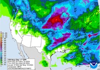
July 2016: Summertime Pattern To End July
my local forecast had rain all week today -today it went poof!! Hunker down and try to stay cool for next 10plus weeks. Dog days of summer are upon us -July, August and most of September.
-
jojotheidiotclown
- Posts: 46
- Joined: Wed Apr 25, 2012 4:01 pm
- Contact:
Meh, this isn't a "heatwave". 100+ day after day is a heatwave.
Will take this every day over rain and flooding. Sun and fun in the summer!
Will take this every day over rain and flooding. Sun and fun in the summer!

jojotheidiotclown wrote:Meh, this isn't a "heatwave". 100+ day after day is a heatwave.
Will take this every day over rain and flooding. Sun and fun in the summer!

The dew point has been pretty high. It actually feels hotter than most of the last couple of summers...although we did have some extreme heat last August.
We have a rogue set of outflow boundaries descending from DFW storms of this afternoon. Not sure the broken line of cells will make it to CLL and northern HGX area cos, but possibility is entertaining and sprinklers on stun for now.

We have a rogue set of outflow boundaries descending from DFW storms of this afternoon. Not sure the broken line of cells will make it to CLL and northern HGX area cos, but possibility is entertaining and sprinklers on stun for now.
-
srainhoutx

- Site Admin

- Posts: 19616
- Joined: Tue Feb 02, 2010 2:32 pm
- Location: Maggie Valley, NC
- Contact:
Rain chances look a bit better today as some increased Gulf moisture as well as left over outflow boundaries from the N Texas storm complex has drifted down to the SE Texas Area. Morning cloud cover with a bit better instability is noted even here in NW Harris County this morning. Hopefully we can squeeze out a bit of rainfall today before the African Dust noted offshore moves inland and reduces rain chances tomorrow.

Tuesday into Thursday suggest another NW Caribbean/Gulf moisture surge may move inland and increase our rain chances once again. The Global models do suggest the Upper Ridge will somewhat reconfigure over the Central Plains next week with Coastal Texas being along the Southern periphery of the Plains Heat Ridge. This could allow for Daily seabreeze and heat of the day showers and storms to develop and move inland.
The longer range models are beginning to suggest some changes may be brewing, particularly toward the end of July as lowering pressures begin to develop across the Tropical Atlantic as the Sahel Monsoon season begins in earnest. We will need to monitor the Tropics a bit more closely as August begins and the Tropical Waves crossing the Eastern/Central Atlantic may see somewhat more favorable conditions as the Saharan Dust abates and pressures fall across the Main Development Region toward the Caribbean Sea. The flurry of Tropical Cyclones in the Eastern Pacific look to wane as the Madden Julian Oscillation eventually shifts Eastbound into the Atlantic Basin and Sea Surface Temperatures begin to cool further across the Eastern and Central Pacific. We will Update the Tropical Outlooks a bit more frequently in our Hurricane Central section as we steadily march toward Peak Hurricane Season and will certainly make any potential Tropical Trouble threats readily available across the entire KHOU Weather Forum Platform, should they occur.
Tuesday into Thursday suggest another NW Caribbean/Gulf moisture surge may move inland and increase our rain chances once again. The Global models do suggest the Upper Ridge will somewhat reconfigure over the Central Plains next week with Coastal Texas being along the Southern periphery of the Plains Heat Ridge. This could allow for Daily seabreeze and heat of the day showers and storms to develop and move inland.
Carla/Alicia/Jerry(In The Eye)/Michelle/Charley/Ivan/Dennis/Katrina/Rita/Wilma/Humberto/Ike/Harvey
Member: National Weather Association
Facebook.com/Weather Infinity
Twitter @WeatherInfinity
Member: National Weather Association
Facebook.com/Weather Infinity
Twitter @WeatherInfinity
Last night's boundary is set up from Austin to Huntsville. Hoping for some fireworks this afternoon. I ran the sprinklers last night after the cells fizzled, so that pretty much *guarantees* rain! 
The cloud cover has been nice today, while it's humid outside, it's not blazing hot. Hoping we can squeeze some moisture out of the skies.
Saharan dusty air arrived at the mid levels this afternoon, While it squelched the rain chances, drier and windier air filtered in, and a welcome change in humidity. It's funny thinking about a DP of 68° as "dry air," but it certainly feels pleasant this evening.
New poster on this forum though some of you might recognize me from another forum. Hoping for some relief later in the month for the Austin area.
-
BiggieSmalls

- Posts: 92
- Joined: Thu Feb 04, 2010 10:05 am
- Location: Dallas, Texas
- Contact:
No doubt, dewpoints in the 60s make a difference, at least to me.
-
srainhoutx
- Site Admin
- Posts: 19616
- Joined: Tue Feb 02, 2010 2:32 pm
- Location: Maggie Valley, NC
- Contact:
Dry hazy and hot weather looks to continue with African dust covering the Region again today. Generally hot and dry weather is expected to continue the rest of the workweek, but some potential changes are lurking as the weekend approaches.
The computer models are suggesting the possibility of a 500mb upper trough/shear axis organizing over Southern Louisiana and meandering West beneath the Upper Ridge anchored over the Plains. Also an inverted trough forms in the Bay of Campeche and the Western Gulf suggesting increasing tropical moisture may push towards the NE Mexico and Texas Coast. The combination of these various features suggest the potential of some showers and storms developing later Saturday into Sunday, possibly increasing a bit more next Monday as the Upper Low moves a bit further West into Mexico. Fingers crossed that we may get some cooling showers across some neighborhoods this upcoming weekend.
The computer models are suggesting the possibility of a 500mb upper trough/shear axis organizing over Southern Louisiana and meandering West beneath the Upper Ridge anchored over the Plains. Also an inverted trough forms in the Bay of Campeche and the Western Gulf suggesting increasing tropical moisture may push towards the NE Mexico and Texas Coast. The combination of these various features suggest the potential of some showers and storms developing later Saturday into Sunday, possibly increasing a bit more next Monday as the Upper Low moves a bit further West into Mexico. Fingers crossed that we may get some cooling showers across some neighborhoods this upcoming weekend.
Carla/Alicia/Jerry(In The Eye)/Michelle/Charley/Ivan/Dennis/Katrina/Rita/Wilma/Humberto/Ike/Harvey
Member: National Weather Association
Facebook.com/Weather Infinity
Twitter @WeatherInfinity
Member: National Weather Association
Facebook.com/Weather Infinity
Twitter @WeatherInfinity
-
srainhoutx
- Site Admin
- Posts: 19616
- Joined: Tue Feb 02, 2010 2:32 pm
- Location: Maggie Valley, NC
- Contact:
The morning Updated Day 11+ GFS Super Ensembles are suggesting a bit of a pattern change may be developing as we head toward the last days of July. The Upper Ridge that has brought our hot and dry weather is expected to shift a bit toward the Great Lakes/Mid/Upper Mississippi Valley Region bringing a fairly impressive heat wave to the Great Lakes/Ohio River Valley and the NE. As the Ridge shifts East, there are some indications that pressures begin to lower across the Caribbean Sea and the Gulf of Mexico. The ECMWF Ensembles are in somewhat agreement with such a shift, so it will be interesting to monitor the trends as we head into late July. It is noteworthy that the Madden Julian Oscillation Pulse that has assisted in cranking out all of the Tropical Cyclones in the Eastern Pacific finally moves into the Atlantic Basin. If the projected Hemispheric Patterns do develop, we may need to watch the Tropics a bit closer as we steadily head toward Peak Hurricane Season in our part of the World.
- Attachments
-
Carla/Alicia/Jerry(In The Eye)/Michelle/Charley/Ivan/Dennis/Katrina/Rita/Wilma/Humberto/Ike/Harvey
Member: National Weather Association
Facebook.com/Weather Infinity
Twitter @WeatherInfinity
Member: National Weather Association
Facebook.com/Weather Infinity
Twitter @WeatherInfinity
-
tireman4

- Global Moderator

- Posts: 4488
- Joined: Wed Feb 03, 2010 9:24 pm
- Location: Humble, Texas
- Contact:
000
FXUS64 KHGX 121001
AFDHGX
Area Forecast Discussion
National Weather Service Houston/Galveston TX
501 AM CDT TUE JUL 12 2016
.DISCUSSION...
Isolated showers developing along the coast early this morning as
the moderate/strong onshore flow persists. At this time not expec-
ting this activity to make it too far inland before it dissipates.
With SE TX remaining on the back side of the shear axis aloft, we
should very limited development through the afternoon/evening (if
any). We are likely to see a repeat for tomorrow but with perhaps
just a slightly bit more coverage...especially for locations east
of I-45 (due to the proximity of the shear axis).
While the larger scale features remain fairly static the next few
days (with SE TX in the weakness region between the two upper rid-
ges), we could be seeing slightly increased rain chances with the
approach/passage of a rather well-defined disturbance from the NE
and E (under the ridge to the west). This feature combined with a
rise in Gulf moisture (PWs near 2in) will help to account for SCT
POPS over the weekend. Looking way ahead into next week, extended
models indicating hot/dry weather on the way as the western ridge
moves into the Central Plains and just sits..and sits. 41
&&
.MARINE...
Small Craft Should Exercise Caution flags will continue through 15z
then should come down as winds over the water gradually relax.
Isolated showers this morning should also be coming to end around
the same time with the diminishing of the mornings speed convergence.
Winds come back up tonight and waters beyond 20 nm may need another
SCEC. Otherwise the forecast looks pretty similar into the weekend
with S to SE 10-15 knots. Next plume of Saharan dust may arrive late
Wednesday or more like Thursday. Currently this plume in the
Caribbean appears larger and with higher concentrations than the
last one so visby may fall below 4-5 miles if the last one is a good
gauge. Tides slightly elevated as well at 0.5 to 1 foot above normal
and this should continue through the weekend. Winds becoming a
little more easterly early next week as upper ridge strengthens
which could bump up the tides further.
45
&&
.AVIATION...
Patchy MVFR CIGS 1800-2700FT this morning inland with VCSH for
LBX/GLS. Winds southerly today getting gusty by mid morning and with
VFR conditions. Probably see a return of the patchy MVFR CIGS again
tonight in the north and northwest.
45
&&
.PRELIMINARY POINT TEMPS/POPS...
College Station (CLL) 97 77 97 77 97 / 10 10 10 10 10
Houston (IAH) 97 79 97 79 97 / 10 10 20 10 20
Galveston (GLS) 91 82 91 82 91 / 10 10 10 10 10
&&
.HGX WATCHES/WARNINGS/ADVISORIES...
TX...NONE.
GM...SMALL CRAFT SHOULD EXERCISE CAUTION until 10 AM CDT this morning
FOR THE FOLLOWING ZONES: Coastal waters from Freeport to
the Matagorda Ship Channel out 20 NM...Coastal waters from
High Island to Freeport out 20 NM...Waters from Freeport to
the Matagorda Ship Channel from 20 to 60 NM...Waters from
High Island to Freeport from 20 to 60 NM.
&&
$$
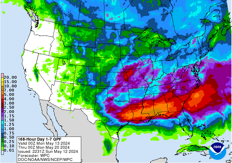
7-day QPF http://www.wpc.ncep.noaa.gov/qpf/p168i.gif?1468400198

http://www.wpc.ncep.noaa.gov/discussion ... isc=qpfpfd
333 AM EDT WED JUL 13 2016
days 2/3...
...central/southern plains to south/southeast...
the potential for organized heavy to possibly excessive rain will be an issue on thurs for parts of the central plains. otherwise over the two days... a quasi-stationary/stalled front stretching from the southeast to the plains will delineate a slightly cooler/drier air mass to the north and typical hot and humid to the south... while being the focus for scattered showers/storms. an upper ridge extending from the southwest to tx on thurs will see the ern portion of this upper high break down and a weak upper impulse from srn co/nrn nm will eject out into ks/ok to likely evolve into an organized convective heavy rain cluster and this is where parts of srn ks/nrn ok is placed in a slight risk for excessive. the wrly to nwrly flow aloft will continue into fri with more small scale vorts potentially ejecting out into the plains but nothing as definable as thurs. expect more pockets of organized convective rains from sd/ne south into ok... while downstream invof of the stalled front and south of it expect scattered showers/storms from the tn valley/south and southeast to the gulf coast. wpc generally followed a blend/compromise of the guidance both days for qpf amounts.
from CPC http://www.cpc.ncep.noaa.gov/products/G ... ring.shtml
pattern following close to last summer!
-
tireman4
- Global Moderator
- Posts: 4488
- Joined: Wed Feb 03, 2010 9:24 pm
- Location: Humble, Texas
- Contact:
000
FXUS64 KHGX 130952
AFDHGX
Area Forecast Discussion
National Weather Service Houston/Galveston TX
452 AM CDT WED JUL 13 2016
.DISCUSSION...
Isolated showers are developing/moving north across the nearshore
waters this morning. This activity should remain south of I-10 in-
to the mid/late morning hours before mixing out. Slightly increas-
ed Gulf moisture along with daytime heating will help produce ISO
SHRA/TSRAs later this afternoon...for locations generally east of
I-45 (given the proximity of the upper level shear axis). We will
likely see a similar pattern for tomorrow as the same features re-
main in place. While hot and humid conditions will persist across
SE TX the next couple of days...heat indicies should remain under
criteria given the daytime mixing (per forecast soundings).
Rain chances are still progged to become a bit more widespread by
the weekend with the approach/passage of a shortwave from the ENE
as the main upper level weakness area/shear axis shifts westward.
While lift/daytime heating do look favorable for rain there could
be a fair bit of lingering subsidence to overcome. 20-30% POPS do
look the way to go at this time. Strong/broad upper level ridging
appears to be the way the long-range forecast is going next week.
As such...this weekend could be our last best chances for rain if
the extended progs do verify. 41
&&
.MARINE...
A ridge of high pressure in the Gulf will maintain onshore flow
through next week. Southerly winds become more southeasterly Friday
night and Saturday as ridge axis moves north and aligns along the
Gulf Coast. This should lead to a longer fetch but with relatively
light winds near 10 knots. Seas of 2-4 feet should prevail through
at least mid week. Slightly elevated tide levels will continue.
Large area of Saharan dust over the Western Caribbean and Yucatan
may spread into the marine waters late tonight and Thursday leading
to reduced visibilities. Isolated showers this morning will likely
return Saturday and may even increase in coverage Sunday as deeper
moisture spreads into the area.
45
&&
.AVIATION...
A few showers near the coast as expected but these should dissipate
with weakening of the speed convergence near the coast after 7 am if
not sooner. Patchy IFR cigs at CLL and split channel satellite
showing the expansion of the lowered CIGS from around 66R to near
UTS northward and this will probably expand a little further south
before sunrise to encompass areas closer to CXO. Heating should
rapidly mix this deck out and CU field should develop with southerly
winds 10-15kts by mid morning. Return of patchy MVFR CIGS expected
near CLL after 06z THU. Dust may move into the area toward morning
THU hampering visibility and can`t rule out haze/dust visibilities
down to 4 to 5 miles. Not certain the highest concentrations of dust
will reach into Houston hubs or be focused further west.
45
&&
.PRELIMINARY POINT TEMPS/POPS...
College Station (CLL) 97 77 97 77 97 / 10 10 10 10 10
Houston (IAH) 97 79 97 77 97 / 20 10 20 10 20
Galveston (GLS) 91 82 91 83 91 / 20 10 10 10 20
&&
.HGX WATCHES/WARNINGS/ADVISORIES...
TX...NONE.
GM...NONE.
&&
$$
Discussion...99

It's my fault.
My house was repainted, and a new gutter system was added on.
(It rained the day before that was completed, and not a drop since).
My house was repainted, and a new gutter system was added on.
(It rained the day before that was completed, and not a drop since).
-
srainhoutx
- Site Admin
- Posts: 19616
- Joined: Tue Feb 02, 2010 2:32 pm
- Location: Maggie Valley, NC
- Contact:
Hot and steamy weather continues and perhaps an isolated shower or storm may be possible late in the weekend after the next surge of African dust passes. The afternoon Updated Climate Predication Center is indicating a bit of a potential change in the Day 8 to 14 Range with increasing tropical moisture from the Western Caribbean Sea arriving into the Western Gulf and possibly an Easterly Wave arriving as well. There are growing indications that all that Tropical Activity in the Eastern Pacific may relax with cooling sea surface temperatures from upwelling of all the Tropical Cyclone traversing that Basin. Typically as conditions become a bit hostile in the Eastern Pacific, tropical development potential increases in the Atlantic Basin and particularly in the Caribbean Sea and the Gulf of Mexico. We will continue to monitor the tropics for any potential mischief as we near that slow and steady climb toward Peak Hurricane Season the North Atlantic Basin.
Eric Blake @EricBlake12 · 4h4 hours ago
The parade of eastern Pacific storms has caused quite a bit of ocean cooling in the past week @TropicalTidbits
The parade of eastern Pacific storms has caused quite a bit of ocean cooling in the past week @TropicalTidbits
Carla/Alicia/Jerry(In The Eye)/Michelle/Charley/Ivan/Dennis/Katrina/Rita/Wilma/Humberto/Ike/Harvey
Member: National Weather Association
Facebook.com/Weather Infinity
Twitter @WeatherInfinity
Member: National Weather Association
Facebook.com/Weather Infinity
Twitter @WeatherInfinity
-
tireman4
- Global Moderator
- Posts: 4488
- Joined: Wed Feb 03, 2010 9:24 pm
- Location: Humble, Texas
- Contact:
000
FXUS64 KHGX 141015
AFDHGX
Area Forecast Discussion
National Weather Service Houston/Galveston TX
515 AM CDT THU JUL 14 2016
.DISCUSSION...
Radar fairly quiet this morning, with most of the activity well E/
NE of the area. Development this afternoon is expected to be isol-
ated and generally east of I-45 once again (given the proximity of
the upper level shear axis to the east and the ridge out west). As
we saw yesterday, SE TX could also see some elevated heat indicies
(102-107F) once again late today. Will hold off on a heat advisory
at this time as we should remain just under criteria. The forecast
of slightly lower PWs tomorrow (into the weekend) will likely help
to ease the HI values a bit as well.
Not too many changes to the grids are planned for the weekend. GFS
appears to be backing off POPS (as it tracks the shortwave further
south across the Gulf waters) but ECMWF is holding firm. Given the
uncertainty, not that fussed with the 20-30% POPS already in grids
(highest over the eastern CWA). Looking ahead, long-range guidance
keeping with the development of a strong upper ridge centered over
the south central Plains next week. While this could translate in-
to the continuation of above normal temps for next week...we still
cannot rule out some isolated (mainly daytime) precipitation as we
remain on the "bottom" of the ridge and open to the prospects of a
shortwave or two moving in from the east. 41
&&
.MARINE...
Typical July weather expected the next few days. Southerly flow of
10 to 15 knots with isolated showers. Dust from the Saharan appears
to be surging northwest across the Gulf and may hamper visibility
the next couple of days with dust and haze. Rain chances increase
Saturday as greater moisture follows in the wake of the dust and
will need to keep an eye to the northeast and east as a series of
upper level disturbances drop down the Mississippi Valley and may
make the turn under the ridge. If so they may bring a more organized
nature to the afternoon storms over LA into the Upper Texas coastal
waters Saturday. Winds may ramp up slightly tonight sufficiently to
warrant a SCEC for 6 hours or so in the southwestern coastal
waters.
45
&&
.AVIATION...
As has been the case the last 3 night...patchy MVFR CIGS mainly IAH
northward again early this morning. These should scatter and lift
early this morning with VFR conditions prevailing. Soundings still
paint a warm profile but with enough moisture for isolated showers
and thunderstorms. The inversion probably will be sufficient to
limit development so for now plan to keep any VCSH/VCTS out of the
TAFS. Again tonight expect patchy mvfr cigs with greater confidence
that CLL will see MVFR cigs after 07z.
45
&&
.PRELIMINARY POINT TEMPS/POPS...
College Station (CLL) 98 78 98 78 97 / 10 10 10 10 20
Houston (IAH) 98 79 98 79 97 / 20 10 20 10 20
Galveston (GLS) 92 82 92 82 91 / 10 10 10 20 20
&&
.HGX WATCHES/WARNINGS/ADVISORIES...
TX...NONE.
GM...NONE.
&&
$$
Discussion...99