

April 2016 Recap: Regional Flood/Severe Weather
-
srainhoutx

- Site Admin

- Posts: 19616
- Joined: Tue Feb 02, 2010 2:32 pm
- Location: Maggie Valley, NC
- Contact:
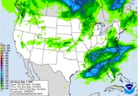
Very active weather pattern ahead for the next 5 days. We are expecting the first round of showers and storms overnight tonight as thunderstorms blossom along and ahead of a dryline just West of the I-35 Corridor of West Central Texas. Water vapor imagery shows a powerful jet streak rotating beneath the base of the Western trough over Arizona while deep tropical moisture from the Eastern Pacific rides the sub tropical jet as it lifts N in response to a potent cold core upper low spinning near the 4 Corners Region. The trough should begin to move ENE and become negative tilted later today bringing a severe weather outbreak across the Great Plains.
Across Texas, the primary threat appears to be large damaging hail and gusty winds with a possible tornado or two. The late afternoon storms may congeal into a squall line and march E overnight and weaken tomorrow morning as a cold pool develops late Wednesday into Thursday stabilizing the atmosphere. The next storm system organizes on Friday and sets the stage for another round of storms late Friday into Saturday. The fly in the ointment late Friday is the potential for a slow moving Pacific front meandering across Central Texas. The Storm Prediction Center has outlined a potential risk for severe storms Friday into Saturday across our Region. Right now the greatest threat for flooding excessive rainfall appears to be focused over the Arklatex Region, but there is some concern that training storms may develop Friday night into Saturday. The GFS is a bit faster moving the storms out while the European model is about 12 hours slower. Stay tuned for updates later today for the Severe Weather Outbreak threat and throughout the week for the Friday into the weekend weather worries.
Across Texas, the primary threat appears to be large damaging hail and gusty winds with a possible tornado or two. The late afternoon storms may congeal into a squall line and march E overnight and weaken tomorrow morning as a cold pool develops late Wednesday into Thursday stabilizing the atmosphere. The next storm system organizes on Friday and sets the stage for another round of storms late Friday into Saturday. The fly in the ointment late Friday is the potential for a slow moving Pacific front meandering across Central Texas. The Storm Prediction Center has outlined a potential risk for severe storms Friday into Saturday across our Region. Right now the greatest threat for flooding excessive rainfall appears to be focused over the Arklatex Region, but there is some concern that training storms may develop Friday night into Saturday. The GFS is a bit faster moving the storms out while the European model is about 12 hours slower. Stay tuned for updates later today for the Severe Weather Outbreak threat and throughout the week for the Friday into the weekend weather worries.
- Attachments
-
Carla/Alicia/Jerry(In The Eye)/Michelle/Charley/Ivan/Dennis/Katrina/Rita/Wilma/Humberto/Ike/Harvey
Member: National Weather Association
Facebook.com/Weather Infinity
Twitter @WeatherInfinity
Member: National Weather Association
Facebook.com/Weather Infinity
Twitter @WeatherInfinity
Can anyone give me an idea about this coming Saturdays weather (rain chances) for Baytown area? I check 5 different places and get 5 different forecasts...Thanks.
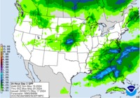
Jeff Lindner's email Tuesday 4/26/2016 - Morning:
Widespread heavy rainfall threat looks to return late this week and this weekend.
Discussion:
Warm and moist southerly flow continues to pump copious moisture into the region ahead of a storm system lifting through the plains today. Surface dryline over W TX this morning will mix eastward to near I-35 this afternoon. Strong heating along and east of this feature will result in a strongly unstable air mass and expect rapid development of severe thunderstorms by mid to late afternoon along and just W of I-35 from near/N of Austin to W of Fort Worth. These storms will have a very large hail and damaging wind threat…although an isolated tornado will also be possible.
These storms will move toward the ENE overnight and possibly clip our northern counties north of a line from College Station to Lake Livingston. A couple of the high resolution models show a more southward extent of this line, but mid level capping will likely preclude significant southward development. Expect an overall thin line of showers with perhaps a thunderstorms passing across the area tonight into early Wednesday.
Rainfall amounts will generally average less than an inch for most areas.
Friday-Saturday:
Concern is growing for another large scale excessive rainfall event.
Another upper level storm system drops into the SW US helping to pull an extremely moist air mass across SE TX on Friday. Air mass looks initially capped, but surface heating may be enough to erode the capping by early afternoon allowing scattered showers and thunderstorms to develop. Cooling mid levels combined with the approach of a slow moving surface front, strong low level inflow, and good divergence aloft is pointing toward slow moving training thunderstorms Friday night into Saturday. Meso scale influences will almost certainly come into play and likely drive this event, but the overall setup is pointing toward widespread heavy rainfall over much of eastern TX. Moisture levels climbing to near 2.0 inches of PW is also concerning with potential for those high hourly rainfall rates which can do so much damage in this area.
For now will go with widespread amounts of 1-3 inches Friday-Saturday with isolated totals upwards of 4-5 inches. These totals will need to be redefined over the coming days to reflect the best model data and hopefully expected location of maximum totals.
Hydro:
Rivers are pushing their flood flows nicely with recessions in progress at all sites except along the Trinity basin where upstream flows are making it toward Lake Livingston.
For the first time in 7 years a floodgate was opened at Mansfield Dam on Lake Travis yesterday as the lake has risen over 3ft into its flood pool. Inflows continue into the Highland Lakes chain and flood gate operations are ongoing at Buchannan and Travis and will continue this week to help lower pool elevations and manage inflows.
Addicks/Barker:
Flood gate releases continue into Buffalo Bayou, but only a very slow fall in pool elevations is expected at these reservoirs. Additional rainfall across these watersheds late this week could result in new rises…depending on how much rain falls and where. These two reservoirs will remain highly sensitive to rainfall for the next few weeks.
The region faces a delicate hydro situation over the next week as saturated grounds and swollen rivers and creeks will not be able to handle additional widespread heavy rainfall. Forecasted late week QPF is concerning especially given the potential widespread nature of the event being shown affecting large portions of area watersheds.
should be a busy day for chasers - hope they all use common senseunome wrote:on a positive note - I continue to be impressed at the lack of mosquitoes in our area
WPC's 6-Hour QPF loop, days 1-7: http://www.wpc.ncep.noaa.gov/qpf/qpfloop_6hr_d17.html
day 1...............................vs..............................day 2
Short Range Loop


https://www.google.com/search?q=storm+chaser+map
-
houstonia
- Posts: 138
- Joined: Sun Jun 14, 2015 6:51 pm
- Location: Houston, Texas (Southwest side; Sharpstown)
- Contact:
Good morning everyone,
I know that Friday/Saturday weather is still fairly unknown (exactly WHERE the rain is going to happen and WHEN). However, I'm hoping people out there have some advice. My brother and sister-in-law will be leaving Houston around 9:00 am Friday morning to drive back to their home in Michigan. They are taking 59 to 30 to 40 to, I think, 55 and then zipping around the lake.
They are planning on spending Friday night in Blytheville Arkansas. I said they probably will have storms on their back Friday, but that stopping in Blytheville on Friday night might put them in the thick of the storm system moving through. On the other hand, I'm not sure if there's any alternate route that would keep them out of the storm system that will be trekking east. Opinions?
-
srainhoutx
- Site Admin
- Posts: 19616
- Joined: Tue Feb 02, 2010 2:32 pm
- Location: Maggie Valley, NC
- Contact:
Sure looks like the Arklatex Region will be under the gun for a lot of training storms. The best advice I could offer is possibly consider leaving on Thursday ~vs~ Friday. That looks like the best weather day of the week. Also with the guidance not pushing the Pacific front through until sometime Monday/Tuesday, there may be another chance for storms late Sunday into Monday. Unfortunately these storm systems are going to impact a lot of real estate all the way to the Great Lakes Region. Wish we had better news for your family that has traveled a long way to visit.houstonia wrote:Good morning everyone,
I know that Friday/Saturday weather is still fairly unknown (exactly WHERE the rain is going to happen and WHEN). However, I'm hoping people out there have some advice. My brother and sister-in-law will be leaving Houston around 9:00 am Friday morning to drive back to their home in Michigan. They are taking 59 to 30 to 40 to, I think, 55 and then zipping around the lake.
They are planning on spending Friday night in Blytheville Arkansas. I said they probably will have storms on their back Friday, but that stopping in Blytheville on Friday night might put them in the thick of the storm system moving through. On the other hand, I'm not sure if there's any alternate route that would keep them out of the storm system that will be trekking east. Opinions?
Carla/Alicia/Jerry(In The Eye)/Michelle/Charley/Ivan/Dennis/Katrina/Rita/Wilma/Humberto/Ike/Harvey
Member: National Weather Association
Facebook.com/Weather Infinity
Twitter @WeatherInfinity
Member: National Weather Association
Facebook.com/Weather Infinity
Twitter @WeatherInfinity
-
srainhoutx
- Site Admin
- Posts: 19616
- Joined: Tue Feb 02, 2010 2:32 pm
- Location: Maggie Valley, NC
- Contact:
For the Dallas Area:
PUBLIC INFORMATION STATEMENT
NATIONAL WEATHER SERVICE FORT WORTH TX
1041 AM CDT TUE APR 26 2016
...DALLAS NOAA ALL HAZARDS RADIO EXPERIENCING TRANSMISSION
PROBLEMS...
THE DALLAS NOAA ALL HAZARDS RADIO TRANSMISSION OPERATING ON THE
FREQUENCY OF 162.400 MHZ IS EXPERIENCING TRANSMISSION PROBLEMS AND
ITS BROADCAST MAY BE INTERMITTENT AT TIMES. TECHNICIANS HAVE BEEN
NOTIFIED BUT WE DO NOT HAVE A RESTORATION TIME.
Carla/Alicia/Jerry(In The Eye)/Michelle/Charley/Ivan/Dennis/Katrina/Rita/Wilma/Humberto/Ike/Harvey
Member: National Weather Association
Facebook.com/Weather Infinity
Twitter @WeatherInfinity
Member: National Weather Association
Facebook.com/Weather Infinity
Twitter @WeatherInfinity
That is unfortunate timing. Hope they get that fixed asap.srainhoutx wrote:For the Dallas Area:
PUBLIC INFORMATION STATEMENT
NATIONAL WEATHER SERVICE FORT WORTH TX
1041 AM CDT TUE APR 26 2016
...DALLAS NOAA ALL HAZARDS RADIO EXPERIENCING TRANSMISSION
PROBLEMS...
THE DALLAS NOAA ALL HAZARDS RADIO TRANSMISSION OPERATING ON THE
FREQUENCY OF 162.400 MHZ IS EXPERIENCING TRANSMISSION PROBLEMS AND
ITS BROADCAST MAY BE INTERMITTENT AT TIMES. TECHNICIANS HAVE BEEN
NOTIFIED BUT WE DO NOT HAVE A RESTORATION TIME.
-
srainhoutx
- Site Admin
- Posts: 19616
- Joined: Tue Feb 02, 2010 2:32 pm
- Location: Maggie Valley, NC
- Contact:
The Storm Prediction Center Day 2 Outlook continues the Slight Risk for severe thunderstorms tomorrow morning. In their discussion, the SPC believes conditions from the Upper Texas Coast on N and E remain favorable for large hail, damaging winds and isolated tornadoes.
- Attachments
-
Carla/Alicia/Jerry(In The Eye)/Michelle/Charley/Ivan/Dennis/Katrina/Rita/Wilma/Humberto/Ike/Harvey
Member: National Weather Association
Facebook.com/Weather Infinity
Twitter @WeatherInfinity
Member: National Weather Association
Facebook.com/Weather Infinity
Twitter @WeatherInfinity
the updated discussionsrainhoutx wrote:The Storm Prediction Center Day 2 Outlook continues the Slight Risk for severe thunderstorms tomorrow morning. In their discussion, the SPC believes conditions from the Upper Texas Coast on N and E remain favorable for large hail, damaging winds and isolated tornadoes.
spc ac 261725
day 2 convective outlook
nws storm prediction center norman ok
1225 pm cdt tue apr 26 2016
valid 271200z - 281200z
...there is a slgt risk of svr tstms from ern tx through a portion
of the lower to middle ms valley and wrn tn valley regions...
...there is a mrgl risk of svr tstms from ern tx through the lower
to middle ms valley...tn/oh valleys...and mid-atlantic...
...summary...
strong to severe thunderstorms will be possible wednesday from the
middle and lower mississippi valley...western tennessee valley into
eastern texas.
...synopsis...
negatively-tilted shortwave trough is expected to move slowly from
cntrl plains newd through the mid mo valley during the period while
maturing. moderately strong mid-level flow associated with the
shortwave trough will spread ewd through the ozark plateau and
mid/lwr ms valleys. farther w...a strong shortwave trough will dig
swd along the w coast...reaching srn ca by 12z thu.
at the surface...low associated with the cntrl plains shortwave is
expected to move only slightly ewd from its position at the
beginning of the period -- over cntrl neb/ks border. pacific cold
front/dryline will extend swd from the low across cntrl ok and into
cntrl tx at 12z wed...moving slowly ewd throughout the day. at
00z/thu...this front is expected to extend from the triple point
over n-cntrl mo sswwd through the arklatex and into se tx.
...e tx ewd/newd through lwr and mid ms valleys...
convection is expected to be ongoing at the beginning of the
period...likely extending from n-cntrl ar swwd to the upper tx
coast. this convective line is expected to persist as it continues
ewd across the lwr ms valley during the morning. for most of the
morning...destabilization downstream of this initial line will be
difficult given the time of day and extensive cloudiness. only
isolated svr is anticipated. some additional tstm activity...with
the possibility of re-intensification...is possible as the line
continues ewd into al but the lack of large-scale forcing for ascent
and generally weak shear should keep any svr threat isolated.
environment behind this initial line...from the mid ms valley swwd
towards the upper tx coast...is expected to destabilize ahead of the
approaching dryline. combination of convergence along the dryline
and weak large-scale forcing for ascent within the unstable
environment will likely result in convective initiation across much
of the region. warm and moist surface conditions beneath steep
mid-level lapse rates may result in mlcape near 2000-2500 j per kg.
additionally...increased mid-level flow will contribute to 0-6 km
bulk shear from 40-50 kt. this type of environment will support
supercells capable of all hazards...although large hail appears to
be the primary severe threat. uncertainties regarding convective
evolution of the early day storms and extent of afternoon
destabilization in their wake remains too high to introduce any
higher probabilities with this forecast.
...mid/lwr mo river valley...
several rounds of tstms are possible across the region wednesday.
potential for some surface-based development exists during the
afternoon as the boundary layer destabilizes and forcing for ascent
persists. primary severe threat is large hail...although sely
surface winds near the boundary may provide sufficient low-level
shear for a tornado threat with any storms that remain surface-based
for a sufficient duration.
...oh valley/mid-atlantic...
tstms are expected to develop along the weak frontal zone extending
from the low over the mid mo valley ewd to nrn nc. shear will be
weak but enough instability will exist to support some isolated hail
and/or damaging wind gusts.
..mosier/guyer.. 04/26/2016
SPC answering questions via Twitter, using #askSPC hashtag - cool !
https://twitter.com/NWSSPC
https://twitter.com/hashtag/askspc?f=tw ... al=default
SPC Experts Drs. Patrick Marsh (@pmarshwx) & James Correia (@jimmyc42) will be answering your questions on this account.
https://twitter.com/NWSSPC
https://twitter.com/hashtag/askspc?f=tw ... al=default
SPC Experts Drs. Patrick Marsh (@pmarshwx) & James Correia (@jimmyc42) will be answering your questions on this account.
-
srainhoutx
- Site Admin
- Posts: 19616
- Joined: Tue Feb 02, 2010 2:32 pm
- Location: Maggie Valley, NC
- Contact:
Gravity waves developing from just NW of San Antonio on up into Oklahoma along the dryline typically suggest the potential of big thunderstorm development in the hours to come.
- Attachments
-
Carla/Alicia/Jerry(In The Eye)/Michelle/Charley/Ivan/Dennis/Katrina/Rita/Wilma/Humberto/Ike/Harvey
Member: National Weather Association
Facebook.com/Weather Infinity
Twitter @WeatherInfinity
Member: National Weather Association
Facebook.com/Weather Infinity
Twitter @WeatherInfinity
looks awesome on the Sector 3 loops http://rammb.cira.colostate.edu/ramsdis ... s-east.asp or the bot https://twitter.com/SRSORbotsrainhoutx wrote:Gravity waves developing from just NW of San Antonio on up into Oklahoma along the dryline typically suggest the potential of big thunderstorm development in the hours to come.
-
srainhoutx
- Site Admin
- Posts: 19616
- Joined: Tue Feb 02, 2010 2:32 pm
- Location: Maggie Valley, NC
- Contact:
NWS STORM PREDICTION CENTER NORMAN OK
0153 PM CDT TUE APR 26 2016
AREAS AFFECTED...WRN/CNTRL OK...NW AND W-CNTRL TX
CONCERNING...SEVERE POTENTIAL...TORNADO WATCH LIKELY
VALID 261853Z - 262100Z
PROBABILITY OF WATCH ISSUANCE...95 PERCENT
SUMMARY...RAPID INITIATION OF TSTMS WILL OCCUR ALONG A DRYLINE FROM
WRN OK INTO NW AND W-CNTRL TX BY MID-AFTERNOON. VERY LARGE
HAIL...DMGG WIND GUSTS AND TORNADOES ARE POSSIBLE. A TORNADO WATCH
WILL LIKELY BE ISSUED IN THE NEXT 1-2 HRS.
DISCUSSION...RICH BOUNDARY-LAYER MOISTURE /CHARACTERIZED BY SFC
DEWPOINTS OF 65-70 F/ IS IN PLACE ACROSS WRN/CNTRL OK AND NW/W-CNTRL
TX...E OF A NEARLY STATIONARY AND WAVY DRYLINE POSITIONED FROM ALVA
OK SSWD TO SWEETWATER TX. ONE-MINUTE VISIBLE SATELLITE IMAGERY SHOWS
WIDESPREAD CU DEVELOPMENT WITHIN THE WARM SECTOR. CINH CONTINUES TO
ERODE AS SFC TEMPERATURES ARE HEATING INTO THE UPPER 70S AND LOWER
80S F. THE LEADING EDGE OF STRONGER FORCING FOR ASCENT ALOFT
ACCOMPANYING AN IMPULSE MOVING ACROSS NM IS SPREADING INTO THE TX
PANHANDLE/SOUTH PLAINS ATTM. AS THIS INTERSECTS THE DRYLINE...RAPID
TSTM INITIATION WILL OCCUR THIS AFTERNOON WITH SUPERCELLS LIKELY.
VERY LARGE HAIL WILL ACCOMPANY TSTMS SOON AFTER INITIATION WITH AN
EXTREMELY UNSTABLE AIR MASS IN PLACE...AS LATEST OBJECTIVE ANALYSIS
DATA ESTIMATE MLCAPE VALUES OVER 3000 J/KG E OF THE DRYLINE. DESPITE
A SUBSTANTIAL MERIDIONAL COMPONENT TO THE DEEP-LAYER WINDS...A
TORNADO THREAT WILL EXIST AND BE MAXIMIZED IN ASSOCIATION WITH ANY
LONGER-LIVED DISCRETE SUPERCELLS THAT CAN EVOLVE. EVENTUAL
CONSOLIDATION INTO CLUSTERS/LINE SEGMENTS SHOULD RESULT IN AN
INCREASING DMGG WIND THREAT THROUGH THE EARLY EVENING AS WELL.
A TORNADO WATCH WILL LIKELY BE ISSUED FOR PARTS OF WRN/CNTRL OK AND
NW/W-CNTRL TX IN THE NEXT 1-2 HRS.
..ROGERS/CORFIDI.. 04/26/2016
ATTN...WFO...TSA...FWD...OUN...SJT...LUB...MAF...
Carla/Alicia/Jerry(In The Eye)/Michelle/Charley/Ivan/Dennis/Katrina/Rita/Wilma/Humberto/Ike/Harvey
Member: National Weather Association
Facebook.com/Weather Infinity
Twitter @WeatherInfinity
Member: National Weather Association
Facebook.com/Weather Infinity
Twitter @WeatherInfinity
-
Texaspirate11

- Posts: 1278
- Joined: Tue Dec 31, 2013 12:24 am
- Contact:
Given the historic flooding last week, our NWS is on it!!!!
THE METEOROLOGY DEPARTMENT AT TEXAS A&M UNIVERSITY WILL BE DOING A
SPECIAL BALLOON RELEASE LATE THIS AFTERNOON TO HELP DETERMINE
WHICH MODELS HAVE THE BEST HANDLE ON THE CAP AND WHEN IT SHOULD
ERODE. THE EVENING SHIFT MAY NEED TO INTRODUCE THUNDERSTORMS IN
THE NORTHERN TERMINALS IF THE CAP PROVES TO BE WEAKER THAN
ANTICIPATED. 44
Just because you're disabled, you don't have to be a victim
Be Weather Aware & Prepared!
Barbara Jordan Winner in Media
Disability Integration Consultant
Be Weather Aware & Prepared!
Barbara Jordan Winner in Media
Disability Integration Consultant
https://twitter.com/NWSNorman
NWS Norman Verified account
@NWSNorman
155pm - a tornado watch will be issued within the next hour for much of Oklahoma and north Texas.
120pm update - special weather balloon data shows strong cap still in place, but still expected to break after 3pm. Stay alert!
NWS Norman Verified account
@NWSNorman
155pm - a tornado watch will be issued within the next hour for much of Oklahoma and north Texas.
120pm update - special weather balloon data shows strong cap still in place, but still expected to break after 3pm. Stay alert!


SEL9
URGENT - IMMEDIATE BROADCAST REQUESTED
TORNADO WATCH NUMBER 109
NWS STORM PREDICTION CENTER NORMAN OK
230 PM CDT TUE APR 26 2016
THE NWS STORM PREDICTION CENTER HAS ISSUED A
* TORNADO WATCH FOR PORTIONS OF
SOUTHWEST AND SOUTH CENTRAL THROUGH NORTH CENTRAL AND NORTHEAST
OKLAHOMA
WEST CENTRAL THROUGH NORTH CENTRAL TEXAS
* EFFECTIVE THIS TUESDAY AFTERNOON FROM 230 PM UNTIL MIDNIGHT
CDT.
...THIS IS A PARTICULARLY DANGEROUS SITUATION...
* PRIMARY THREATS INCLUDE...
SEVERAL TORNADOES AND A FEW INTENSE TORNADOES LIKELY
WIDESPREAD LARGE HAIL AND SCATTERED VERY LARGE HAIL EVENTS TO 4
INCHES IN DIAMETER EXPECTED
WIDESPREAD DAMAGING WINDS LIKELY WITH ISOLATED SIGNIFICANT GUSTS
TO 80 MPH POSSIBLE
SUMMARY...NUMEROUS SEVERE THUNDERSTORMS EXPECTED TO RAPIDLY FORM IN
THE NEXT COUPLE HOURS OVER WESTERN PART OF WATCH...INCLUDING A FEW
STRONG SUPERCELLS CAPABLE OF VERY LARGE HAIL...DAMAGING WIND...AND
TORNADOES. THE STORMS SHOULD MERGE INTO BROKEN LINES AND
CLUSTERS...WITH EMBEDDED SUPERCELLS CONTINUING TO POSE A RISK FOR
VERY LARGE HAIL...DAMAGING WIND.. AND A FEW TORNADOES AS THEY
MOVE/DEVELOP EAST-NORTHEAST INTO TONIGHT.
THE TORNADO WATCH AREA IS APPROXIMATELY ALONG AND 90 STATUTE
MILES EAST AND WEST OF A LINE FROM 20 MILES NORTH NORTHEAST OF
PONCA CITY OKLAHOMA TO 35 MILES SOUTH SOUTHWEST OF BROWNWOOD
TEXAS. FOR A COMPLETE DEPICTION OF THE WATCH SEE THE ASSOCIATED
WATCH OUTLINE UPDATE (WOUS64 KWNS WOU9).
PRECAUTIONARY/PREPAREDNESS ACTIONS...
REMEMBER...A TORNADO WATCH MEANS CONDITIONS ARE FAVORABLE FOR
TORNADOES AND SEVERE THUNDERSTORMS IN AND CLOSE TO THE WATCH
AREA. PERSONS IN THESE AREAS SHOULD BE ON THE LOOKOUT FOR
THREATENING WEATHER CONDITIONS AND LISTEN FOR LATER STATEMENTS
AND POSSIBLE WARNINGS.
&&
OTHER WATCH INFORMATION...CONTINUE...WW 106...WW 107...WW 108...
AVIATION...TORNADOES AND A FEW SEVERE THUNDERSTORMS WITH HAIL
SURFACE AND ALOFT TO 4 INCHES. EXTREME TURBULENCE AND SURFACE
WIND GUSTS TO 70 KNOTS. A FEW CUMULONIMBI WITH MAXIMUM TOPS TO
600. MEAN STORM MOTION VECTOR 23040.
...CORFIDI
WWUS40 KWNS 261930
WWP9
TORNADO WATCH PROBABILITIES FOR WT 0109
NWS STORM PREDICTION CENTER NORMAN OK
0225 PM CDT TUE APR 26 2016
WT 0109 PDS
PROBABILITY TABLE:
PROB OF 2 OR MORE TORNADOES : 90%
PROB OF 1 OR MORE STRONG /F2-F5/ TORNADOES : 80%
PROB OF 10 OR MORE SEVERE WIND EVENTS : 90%
PROB OF 1 OR MORE WIND EVENTS >= 65 KNOTS : 40%
PROB OF 10 OR MORE SEVERE HAIL EVENTS : >95%
PROB OF 1 OR MORE HAIL EVENTS >= 2 INCHES : >95%
PROB OF 6 OR MORE COMBINED SEVERE HAIL/WIND EVENTS : >95%
&&
ATTRIBUTE TABLE:
MAX HAIL /INCHES/ : 4.0
MAX WIND GUSTS SURFACE /KNOTS/ : 70
MAX TOPS /X 100 FEET/ : 600
MEAN STORM MOTION VECTOR /DEGREES AND KNOTS/ : 23040
PARTICULARLY DANGEROUS SITUATION : YES
&&
FOR A COMPLETE GEOGRAPHICAL DEPICTION OF THE WATCH AND
WATCH EXPIRATION INFORMATION SEE WOUS64 FOR WOU9.
$$