
Some are moving in south of Houston but yea.. seems like SW Houston and perhaps the metro might not see near as much as anticipated... Still have tonight though.. So we aren't out of the woods by any means yet.Snowman wrote:Based on the radar, it looks like the storms heading for southeast Texas are moving quickly which should mean that flooding won't be as much of an issue with this batch. Also, it looks like only east of 45 will get the heavy stuff. There is another batch brewing in far south Texas, so will see if that will bring in some more wide spread action.
March 2016 - Progressive Changeable Weather To End The Month

Hmm. No AFD from the NWS yet. Probably pulling their hair out trying to figure out what's gonna happen tonight.
-
srainhoutx

- Site Admin

- Posts: 19616
- Joined: Tue Feb 02, 2010 2:32 pm
- Location: Maggie Valley, NC
- Contact:
NATIONAL WEATHER SERVICE HOUSTON/GALVESTON TXjasons wrote:Hmm. No AFD from the NWS yet. Probably pulling their hair out trying to figure out what's gonna happen tonight.
413 PM CST WED MAR 9 2016
.DISCUSSION...
A CHALLENGING FORECAST PERIOD FOR SOUTHEAST TEXAS CONTINUES
TONIGHT INTO THURSDAY WITH THE POTENTIAL FOR HEAVY RAIN PERSISTING
THROUGH THURSDAY MORNING. THE MAIN FORECAST UPDATE WAS TO EXTEND
THE CURRENT FLASH FLOOD WATCH THROUGH 6 AM CST FOR ALL OF
SOUTHEAST TEXAS.
MANY ENVIRONMENTAL CONDITIONS REMAIN INCREDIBLY FAVORABLE FOR
HEAVY RAIN... WITH DIFFLUENT FLOW ALOFT AHEAD OF AN UPPER LEVEL
LOW APPROXIMATELY 800 MILES SOUTHWEST OF THE REGION OVER MEXICO...
ANOMALOUSLY HIGH PRECIPITABLE WATER VALUES IN EXCESS OF 1.6
INCHES... AND A LARGELY UNIDIRECTIONAL WIND PROFILE ENCOURAGING
TRAINING OF SHOWERS AND STORMS. THE MAIN ISSUE WITH THE
DEVELOPMENT OF HEAVY RAIN HAS BEEN ACTUAL TRIGGERING/FOCUSING
MECHANISMS. SUBTLE SHORTWAVES TRANSLATING ACROSS THE REGION IN THE
FLOW ALOFT HAVE BEEN DIFFICULT TO TIME... BUT HAVE BEEN BIG
DRIVERS IN THUNDERSTORM DEVELOPMENT THROUGH THE DAY TODAY.
ADDITIONALLY... SOUTHEASTERN PORTIONS OF THE FORECAST AREA DID
ACTUALLY EXPERIENCE SOME SUBSIDENCE IN THE WAKE OF CONVECTION
EARLIER THIS MORNING /AS EVIDENCED BY THE ANOMALOUS PROPAGATION
THAT DEVELOPED WHEN THE RADAR BEAM WAS DUCTED DOWNWARD TOWARDS THE
GULF BETWEEN NOON AND 2 PM TODAY/... AND THIS ALSO HELPED LIMIT
SOME OF THE CONVECTIVE ACTIVITY ACROSS THOSE AREAS TODAY.
HOWEVER... IT APPEARS THAT THE ATMOSPHERE HAS HAD ENOUGH TIME TO
RECOVER GIVEN THE LATEST CONVECTIVE TRENDS OVER THE GULF AND
EXPECT NUMEROUS SHOWERS AND THUNDERSTORMS TO CONTINUE ACROSS THE
REGION HEADING INTO THE OVERNIGHT PERIOD GIVEN THE AFOREMENTIONED
CONDITIONS. AFTERNOON SURFACE ANALYSIS DOES SHOW A WEAK FRONTAL
BOUNDARY STRETCHING FROM NEAR MATAGORDA BAY TO HOUSTON HOBBY TO UP
TOWARDS CLEVELAND AS OF 3 PM CST. THIS BOUNDARY HAS SLOWLY SAGGED
SOUTH TOWARDS THE COAST THROUGH THE DAY AND HAS BEEN POORLY
RESOLVED BY SHORT-TERM GUIDANCE IN HOW THIS FEATURE WILL EVOLVE.
COULD SEE HEAVIER RAINFALL FOCUS ALONG THIS BOUNDARY TONIGHT...
WITH WIDESPREAD TOTALS OF 1 TO 3 INCHES AND LOCALLY HIGHER AMOUNTS
POSSIBLE.
WITH THE UPPER LOW WEST OF THE REGION THROUGH THE REMAINDER OF
THE WEEK... HAVE KEPT RAIN CHANCES IN THE FORECAST THURSDAY
THROUGH SATURDAY. COULD SEE A BRIEF LULL IN ACTIVITY BY THURSDAY
AFTERNOON AS DRIER AIR WRAPS AROUND THE UPPER LOW PUSHING INTO
SOUTH CENTRAL TEXAS. DEEPEST MOISTURE IS EXPECTED TO MOVE EAST OF
THE REGION BY LATE THURSDAY... HELPING TO LIMIT THE HEAVY RAIN
THREAT FROM THUNDERSTORM ACTIVITY AFTER THURSDAY. DRY CONDITIONS
AND TEMPERATURES WARMING TO ABOVE SEASONAL NORMALS ARE EXPECTED BY
SUNDAY AS THE UPPER LOW CLEARS THE REGION.
HUFFMAN
Carla/Alicia/Jerry(In The Eye)/Michelle/Charley/Ivan/Dennis/Katrina/Rita/Wilma/Humberto/Ike/Harvey
Member: National Weather Association
Facebook.com/Weather Infinity
Twitter @WeatherInfinity
Member: National Weather Association
Facebook.com/Weather Infinity
Twitter @WeatherInfinity
It's currently raining more in Stafford than it has here all day. < Was home sick today> Hearing some rumblings of thunder and saw a flash of lightning.
I've noticed on both the Houston and Corpus radars, as the convection moves inland & over the front, it seems to fall apart...

Major flooding happening in around Beaumont now. If your in rhis area, many feeder roads and underpassesunder watrer now. Flash Flood warning just issued for Jefferson and Orange counties till 11pm! Stay off the roads if your in the area. Again, major flooding happening now in the Beaumont area! Be safe!
Mike
Beaumont, TX
(IH-10 & College Street)
Beaumont, TX
(IH-10 & College Street)
This is such a roller coaster. Now it seems the incoming lift is enhancing the rain shield and precipitation rates are increasing.
Stay tuned because it may be a different story 30 minutes from now
Stay tuned because it may be a different story 30 minutes from now
i live on east side between baytown and mont belvevu south of I-10 and its rainig hard with thunder and lightning! Yard is starting to flood.
Today really showed me in Beaumont just how quick things can change. Went from zip zero to light rain all day now to major flooding and road and underpasses being closed die to major foooding. These two days have been a doozy! Much more to come overnight it looks like too! Stay safe!
Mike
Beaumont, TX
(IH-10 & College Street)
Beaumont, TX
(IH-10 & College Street)
Radar is def starting to fill in now..
The heavy stuff is weakening as it moves inland. Along the coast looks like to be the place that will see the greatest rainfall totals. Downtown and most of Harris county should see a steady light/moderate rain if the convection continues to weaken as it moves inland.
Still raining in Stafford. But it's a light steady much needed rain.

Alvin getting slammed for the past two hours now, still heavy downpours with thunder and lightning. Ditches are full and I imagine our river is flowing quite nicely right now.
Quick question to my awesome Met friends.... does it look like a tornadic night? That scares me the most while sleeping.... Please say no.
THE NATIONAL WEATHER SERVICE IN LEAGUE CITY HAS ISSUED A
* FLOOD ADVISORY FOR...
GALVESTON COUNTY IN SOUTHEASTERN TEXAS...
* UNTIL 915 PM CST
* AT 708 PM CST...DOPPLER RADAR INDICATED CONTINUED MODERATE RAINFALL ACROSS THE
AREA WITH SOME BURSTS OF HEAVIER RATES AT TIMES. ROADS THAT HAVE DRAINAGE ISSUES
MAY HAVE SOME MINOR STREET FLOODING. THIS INCLUDES GALVESTON ISLAND WHERE THE
STREETS ARE SOMETIMES SLOWER TO DRAIN DUE TO ELEVATED TIDE LEVELS. DO NOT DRIVE
ACROSS WATER COVERED ROADS.
* SOME LOCATIONS THAT WILL EXPERIENCE FLOODING INCLUDE...
SOUTHERN LEAGUE CITY...GALVESTON ISLAND WEST END...GALVESTON
CAUSEWAY...TEXAS CITY...DICKINSON...LA MARQUE...SANTA FE...HITCHCOCK...
GALVESTON PIER 21...BAYOU VISTA...JAMAICA BEACH...TIKI ISLAND...
GALVESTON STATE PARK...THE STRAND...PORT BOLIVAR...OFFATTS BAYOU...HIGH
ISLAND...BOLIVAR PENINSULA...PELICAN ISLAND AND CRYSTAL BEACH.

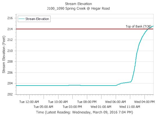
From Jeff .....
Headwaters Spring Creek overbanks. Field Store Rd reported impassable at the creek. Use caution #houwx
Headwaters Spring Creek overbanks. Field Store Rd reported impassable at the creek. Use caution #houwx
~~~When Thunder Roars Go Indoors~~~
~~~Turn Around Don't Drown~~~
~~~Run From The Water, Hide From The Wind~~~
~~~Turn Around Don't Drown~~~
~~~Run From The Water, Hide From The Wind~~~
While the chances aren't Zero .... it is a pretty low probability.kayci wrote:Quick question to my awesome Met friends.... does it look like a tornadic night? That scares me the most while sleeping.... Please say no.

~~~When Thunder Roars Go Indoors~~~
~~~Turn Around Don't Drown~~~
~~~Run From The Water, Hide From The Wind~~~
~~~Turn Around Don't Drown~~~
~~~Run From The Water, Hide From The Wind~~~
FLOOD WARNING
NATIONAL WEATHER SERVICE HOUSTON/GALVESTON, TX
749 PM CST WED MAR 9 2016
...The National Weather Service in Houston/Galveston has issued a flood warning
for the following rivers...
Spring Creek Near Hegar Road affecting the following counties in Texas...
Harris
For Spring Creek at Hegar Road, Minor flooding is forecasted.
Rainfall today has caused the creek to rise out of banks. Field Store Road in
Waller County is blocked at the creek and impassable. Hegar Road south of the
creek is starting to flood. Light to occasional moderate rain will persist
for the next several hours.
PRECAUTIONARY/PREPAREDNESS ACTIONS...
Persons with interests along these streams should keep alert to rising water and
take all precautions to protect their property. Do not drive or walk into
flooded areas the depth and water velocity could be too great for you to cross
safely. Motorists should avoid any water covered roads and find an alternate
route. Livestock and equipment should be removed from the flood plain
immediately.
~~~When Thunder Roars Go Indoors~~~
~~~Turn Around Don't Drown~~~
~~~Run From The Water, Hide From The Wind~~~
~~~Turn Around Don't Drown~~~
~~~Run From The Water, Hide From The Wind~~~
thanks dj, maybe I'll sleep ok tonight.
That's a fear of mine too Kayci. And it was a reality for my family on Halloween. Jolted out of bed at 4:15 am to a roaring sound. Neither mine or my husband's weather alerts went off. It was right on top of us. Barely had enough time to grab the baby and pets to huddle in the bathroom closet. Luckily, our home was not damaged, but it did go through our back field. It was so loud and scary. Seemed like hours, but it was over in minutes. Hoping for just good rain tonight.kayci wrote:Quick question to my awesome Met friends.... does it look like a tornadic night? That scares me the most while sleeping.... Please say no.
-
- Information
-
Who is online
Users browsing this forum: Ahrefs [Bot], Bing [Bot], cperk, Cpv17 and 55 guests